From Surf Wiki (app.surf) — the open knowledge base
South Banat District
Administrative district of Serbia
Administrative district of Serbia
| Field | Value | ||
|---|---|---|---|
| <!-- See Template:Infobox settlement for additional fields and descriptions --> | name | South Banat District | |
| native_name | Јужнобанатски округ | ||
| settlement_type | Administrative district of Serbia | ||
| <!-- maps and coordinates ------> | image_skyline | {{Photomontage | position=center |
| photo1a | Wiki.Vojvodina VI Vršac 215.jpg | ||
| photo1b | Wiki.Vojvodina VI Pančevo 855.jpg | ||
| photo2a | Wiki.Vojvodina VI Pančevo 803.jpg | ||
| photo2b | Wiki.Vojvodina VI Vetropark Alibunar 067.jpg | ||
| photo2c | Wiki.Vojvodina VI Jasenovo 539.jpg | ||
| photo2d | Wiki.Vojvodina VI Bela Crkva 652.jpg | ||
| photo3a | Wiki.Vojvodina VI Uspenska crkva Pančevo 809.jpg | ||
| photo3b | Wiki.Vojvodina VI Vršac 458.jpg | ||
| photo3c | Wiki.Vojvodina VI Vršac 444.jpg | ||
| photo3d | Wiki.Vojvodina VI Crkva svetog Preobraženja (Pančevo) 1054 05.jpg | ||
| photo3e | Clan Kuda Adi Endre.JPG | ||
| photo4a | Deliblato Sands, Foggy morning.jpg | ||
| photo4b | Panc mainmunicipal.png | ||
| photo4c | Vršačke planine.jpg | ||
| photo5a | Dvorac Lazarević, Veliko Središte 17.jpg | ||
| photo5b | Vršac (14349145282).jpg | ||
| photo6a | WV Vojvodina Banner.jpg | ||
| size | 270 | ||
| spacing | 1 | ||
| foot_montage | Images from the South Banat District | ||
| color | #FFFFFF | ||
| border | 1 | ||
| image_map | Map of South Banat in Serbia (with Kosovo independent).svg | ||
| mapsize | 200px | ||
| map_caption | Location of district in Serbia | ||
| coordinates | |||
| <!-- location ------------------> | subdivision_type | Country | |
| subdivision_name | Serbia | ||
| subdivision_type1 | Province | ||
| subdivision_name1 | Vojvodina | ||
| <!-- seat, smaller parts -------> | seat_type | Administrative center | |
| seat | Pančevo | ||
| <!-- government type, leaders --> | leader_title | Commissioner | |
| leader_name | Marina Toman | ||
| total_type | Total | ||
| area_total_km2 | 4,245 | ||
| population_total | 260,244 | ||
| population_as_of | 2022 | ||
| population_density_km2 | auto | ||
| <!-- blank fields (section 1) --> | blank_name_sec1 | Municipalities | |
| blank_info_sec1 | 8 (2 cities) | ||
| blank1_name_sec1 | Settlements | ||
| blank1_info_sec1 | 94 | ||
| blank2_name_sec1 | - Cities and towns | ||
| blank2_info_sec1 | 10 | ||
| blank3_name_sec1 | - Villages | ||
| blank3_info_sec1 | 84 | ||
| iso_code | RS-04 | ||
| website |
The South Banat District (, ) is one of administrative districts of Serbia. It lies in the geographical region of Banat. According to the 2022 census, the South Banat District has a population of 260,244 inhabitants. The administrative center of the district is the city of Pančevo.
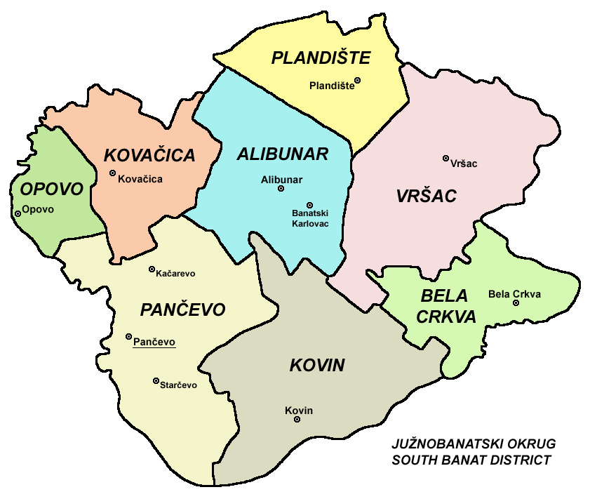
Cities and municipalities
The South Banat District encompasses the territories of two cities and six municipalities:
- Pančevo (city)
- Vršac (city)
- Alibunar (municipality)
- Bela Crkva (municipality)
- Kovačica (municipality)
- Kovin (municipality)
- Opovo (municipality)
- Plandište (municipality)
Demographics
|1948|279092 |1953|291125 |1961|320187 |1971|331285 |1981|340189 |1991|328428 |2002|313937 |2011|293730 |2022|260244
Cities and towns
There are three towns with over 10,000 inhabitants:
- Pančevo: 73,401
- Vršac: 31,946
- Kovin: 11,623
Ethnic structure
| Ethnicity | Population | Share |
|---|---|---|
| Serbs | 187,253 | 72% |
| Romanians | 13,914 | 5.3% |
| Slovaks | 11,007 | 4.2% |
| Hungarians | 8,782 | 3.3% |
| Roma | 8,421 | 3.2% |
| Macedonians | 4,374 | 1.7% |
| Others | 7,851 | 3% |
| Undeclared/Unknown | 18,642 | 7.1% |
Most of the municipalities in the district have Serb ethnic majority, only the municipality of Kovačica has a relative Slovak ethnic majority (41%).
References
Note: All official material made by Government of Serbia is public by law. Information was taken from official website.
References
- "Census 2022 - excel table {{!}} ABOUT CENSUS".
- "2011 Census of Population, Households and Dwellings in the Republic of Serbia". Statistical Office of the Republic of Serbia.
- "Archived copy".
- "Ethnicity - Data by municipalities and cities".
This article was imported from Wikipedia and is available under the Creative Commons Attribution-ShareAlike 4.0 License. Content has been adapted to SurfDoc format. Original contributors can be found on the article history page.
Ask Mako anything about South Banat District — get instant answers, deeper analysis, and related topics.
Research with MakoFree with your Surf account
Create a free account to save articles, ask Mako questions, and organize your research.
Sign up freeThis content may have been generated or modified by AI. CloudSurf Software LLC is not responsible for the accuracy, completeness, or reliability of AI-generated content. Always verify important information from primary sources.
Report