From Surf Wiki (app.surf) — the open knowledge base
Sonora, California
City in California, United States
.jpg)
City in California, United States
| Field | Value |
|---|---|
| name | Sonora, California |
| settlement_type | City |
| image_skyline | Tuolumne County Courthouse.jpg |
| image_caption | The county courthouse |
| image_map | Tuolumne_County_California_Incorporated_and_Unincorporated_areas_Sonora_Highlighted.svg |
| map_caption | Location in Tuolumne County and the state of California |
| pushpin_map | USA |
| pushpin_map_caption | Location in the United States |
| pushpin_relief | 1 |
| subdivision_type | Country |
| subdivision_name | United States |
| subdivision_type1 | State |
| subdivision_name1 | California |
| subdivision_type2 | County |
| subdivision_name2 | Tuolumne |
| leader_title | Mayor |
| leader_title1 | City Administrator |
| established_title | Incorporated |
| established_date | February 15, 1850{{Cite web |
| url | http://www.calafco.org/docs/Cities_by_incorp_date.doc |
| title | California Cities by Incorporation Date |
| format | Word |
| publisher | California Association of Local Agency Formation Commissions |
| access-date | August 25, 2014 |
| url-status | dead |
| archive-url | https://web.archive.org/web/20130221091414/http://www.calafco.org/docs/Cities_by_incorp_date.doc |
| archive-date | February 21, 2013 |
| df | mdy-all |
| unit_pref | Imperial |
| area_footnotes | |
| area_total_sq_mi | 3.18 |
| area_land_sq_mi | 3.16 |
| area_water_sq_mi | 0.01 |
| area_total_km2 | 8.23 |
| area_land_km2 | 8.19 |
| area_water_km2 | 0.04 |
| area_water_percent | 0.43 |
| population_as_of | 2020 |
| population_footnotes | |
| population_total | 5,003 |
| population_density_sq_mi | auto |
| population_density_km2 | auto |
| timezone | Pacific |
| utc_offset | −8 |
| timezone_DST | PDT |
| utc_offset_DST | −7 |
| coordinates | |
| elevation_footnotes | |
| elevation_ft | 1828 |
| postal_code_type | ZIP Codes |
| postal_code | 95370, 95373 |
| area_code_type | Area code |
| area_code | 209 |
| blank_name | FIPS code |
| blank_info | |
| blank1_name | GNIS feature ID |
| blank1_info | 2411930 |
| website |
|access-date = August 25, 2014 |url-status = dead |archive-url = https://web.archive.org/web/20130221091414/http://www.calafco.org/docs/Cities_by_incorp_date.doc |archive-date = February 21, 2013
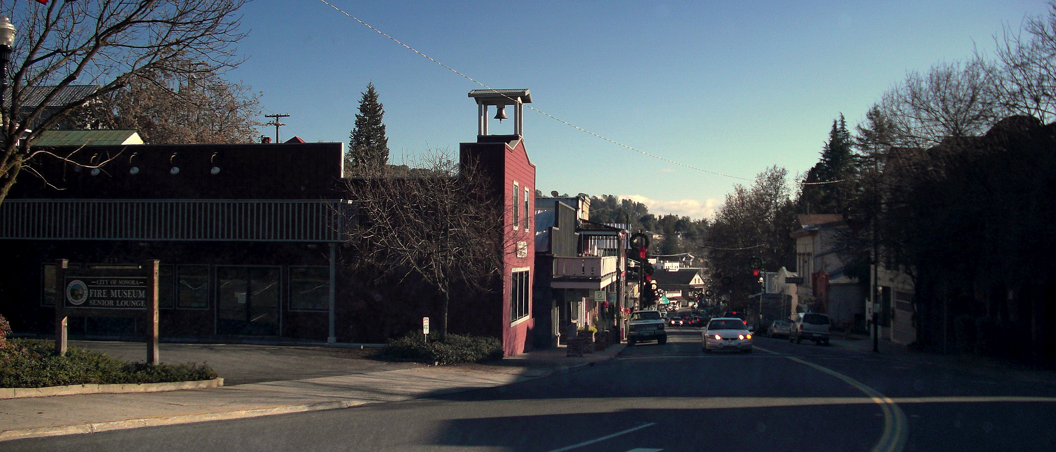
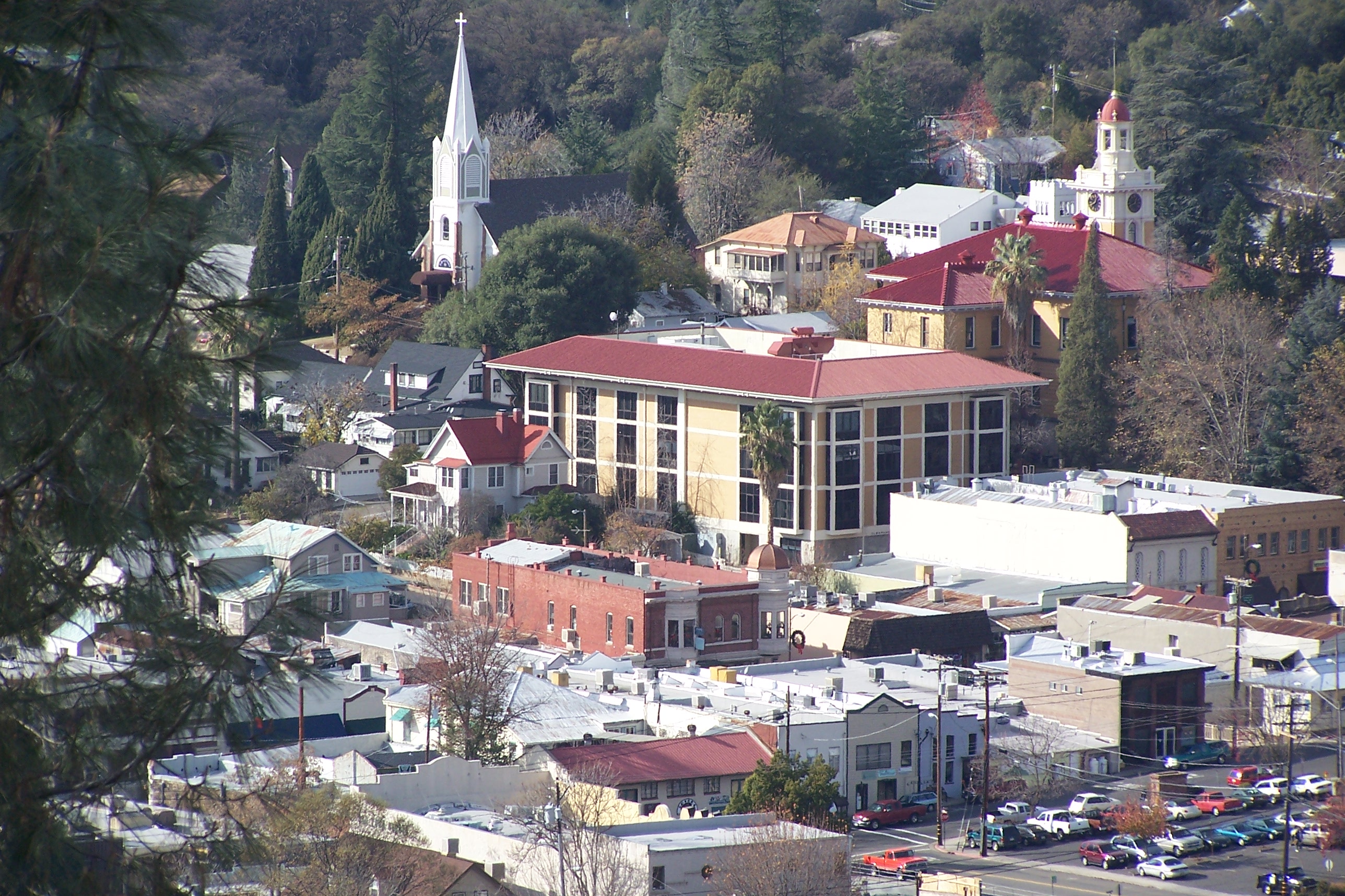
Sonora is the only incorporated city in Tuolumne County, California, United States, of which it is also the county seat. Founded during the California Gold Rush by Mexican miners from Sonora (after which the city is named), the city population was 5,003 during the 2020 census, an increase from the 4,610 counted during the 2010 census.
History
Sonora was founded by Mexican miners during the California gold rush. Sonorans were alongside Chileans among the most experienced miners in the rush. Named after their home state of Sonora, Mexico, it was once a booming center of industry and trade in California's Mother Lode. Most of the gold removable with traditional mining techniques was quickly extracted, leaving miners to use more complex and expensive mining techniques to reach deep pockets of quartz and gold. Sonora as well as other mining towns of the era experienced economic hardship when the value of gold decreased. As "gold fever" died down, Sonora's size and population steadily decreased over the years. In , the Sonora Hebrew Cemetery was formed by the Hebrew Benevolent Society and predominantly contains the graves of European-born Jews who emigrated to Gold Country.
As detailed in the 2005 memoir of novelist David Carkeet, Campus Sexpot, Sonora was fictionalized as "Wattsville", the setting of Dale Koby's cult/underground classic (also titled Campus Sexpot). The sequel, From Roundheel To Revolutionary by Jeff Daiell, also takes place primarily in "Wattsville"/Sonora.
The Tuolumne County Museum and History Center preserves the town's Gold Rush legacy.
Geography
Sonora is located around the intersection of California State Highways 49 and 108 The altitude is 1825 ft. According to the United States Census Bureau, the city covers a total area of 3.2 sqmi, making it the county's largest community by land area. 99.57% of the area is land and 0.43% of it is water.
Climate
There are an average of 75 days annually with highs of 90 °F or higher and an average of 65.5 days annually with lows of 32 °F or lower. The record high temperature was 113 °F on June 22, 1961, and July 15, 1972. The record low temperature was 8 °F on December 9, 1972.
Average annual rainfall is 32.79 in, almost all from November through April, although there are occasionally afternoon and evening thunderstorms in the summer months, which drift down from the Sierra Nevada. There are an average of 63.8 days annually with measurable precipitation. The wettest "rain year" has been from July 1982 to June 1983 with 60.29 in and the driest from July 1975 to June 1976 with 15.26 in. The most rainfall in one month was 21.69 in in December 1955, including 7.1 in on December 27, the record 24-hour rainfall. The most snowfall in one month was 30.5 in in January 1933. The Köppen Climate Classification subtype for this climate is Csa (hot-summer Mediterranean climate).
|Jan record high F = 75 |Feb record high F = 78 |Mar record high F = 84 |Apr record high F = 92 |May record high F = 103 |Jun record high F = 113 |Jul record high F = 113 |Aug record high F = 110 |Sep record high F = 110 |Oct record high F = 100 |Nov record high F = 89 |Dec record high F = 81
|Jan avg record high F = 68.4 |Feb avg record high F = 70.4 |Mar avg record high F = 75.5 |Apr avg record high F = 82.5 |May avg record high F = 91.6 |Jun avg record high F = 99.3 |Jul avg record high F = 102.7 |Aug avg record high F = 101.8 |Sep avg record high F = 98.1 |Oct avg record high F = 89.6 |Nov avg record high F = 77.5 |Dec avg record high F = 68.2 |year avg record high F = 104.4
|Jan avg record low F = 23.9 |Feb avg record low F = 25.7 |Mar avg record low F = 28.3 |Apr avg record low F = 30.7 |May avg record low F = 36.1 |Jun avg record low F = 41.5 |Jul avg record low F = 49.8 |Aug avg record low F = 49.0 |Sep avg record low F = 42.4 |Oct avg record low F = 34.4 |Nov avg record low F = 27.6 |Dec avg record low F = 23.6 |year avg record low F = 21.5
|Jan record low F = 13 |Feb record low F = 15 |Mar record low F = 20 |Apr record low F = 24 |May record low F = 24 |Jun record low F = 34 |Jul record low F = 36 |Aug record low F = 38 |Sep record low F = 35 |Oct record low F = 25 |Nov record low F = 21 |Dec record low F = 8
|access-date = May 23, 2023 |access-date = May 23, 2023
Demographics
|align-fn=center 1850–1870 1880–1890 1900 1910 1920 1930 1940 1950 1960 1970 1980 1990 2000 2010
2020
The 2020 United States census reported that Sonora had a population of 5,003. The population density was 1,581.7 PD/sqmi. The racial makeup of Sonora was 80.0% White, 0.5% African American, 1.6% Native American, 3.0% Asian, 0.4% Pacific Islander, 3.4% from other races, and 11.1% from two or more races. Hispanic or Latino of any race were 13.1% of the population.
The census reported that 97.8% of the population lived in households, 0.7% lived in non-institutionalized group quarters, and 1.5% were institutionalized.
There were 2,301 households, out of which 26.8% included children under the age of 18, 30.2% were married-couple households, 9.4% were cohabiting couple households, 38.0% had a female householder with no partner present, and 22.3% had a male householder with no partner present. 39.1% of households were one person, and 16.7% were one person aged 65 or older. The average household size was 2.13.
The age distribution was 18.8% under the age of 18, 8.4% aged 18 to 24, 26.9% aged 25 to 44, 24.1% aged 45 to 64, and 21.7% who were 65years of age or older. The median age was 41.4years. For every 100 females, there were 87.6 males.
There were 2,515 housing units at an average density of 795.1 /mi2, of which 2,301 (91.5%) were occupied. Of these, 42.0% were owner-occupied, and 58.0% were occupied by renters.
In 2023, the US Census Bureau estimated that the median household income was $62,621, and the per capita income was $39,503. About 17.4% of families and 20.0% of the population were below the poverty line.
2010
.jpg)
At the 2010 census Sonora had a population of 4,903. The population density was 1,593.0 PD/sqmi. The racial makeup of Sonora was 4,402 (89.8%) White, 24 (0.5%) African American, 95 (1.9%) Native American, 79 (1.6%) Asian, 12 (0.2%) Pacific Islander, 84 (1.7%) from other races, and 207 (4.2%) from two or more races. Hispanic or Latino of any race were 542 people (11.1%).
The census reported that 4,613 people (94.1% of the population) lived in households, 85 (1.7%) lived in non-institutionalized group quarters, and 205 (4.2%) were institutionalized.
There were 2,199 households, 562 (25.6%) had children under the age of 18 living in them, 689 (31.3%) were opposite-sex married couples living together, 308 (14.0%) had a female householder with no husband present, 116 (5.3%) had a male householder with no wife present. There were 192 (8.7%) unmarried opposite-sex partnerships, and 12 (0.5%) same-sex married couples or partnerships. 881 households (40.1%) were one person and 312 (14.2%) had someone living alone who was 65 or older. The average household size was 2.10. There were 1,113 families (50.6% of households); the average family size was 2.77.
The age distribution was 975 people (19.9%) under the age of 18, 526 people (10.7%) aged 18 to 24, 1,266 people (25.8%) aged 25 to 44, 1,324 people (27.0%) aged 45 to 64, and 812 people (16.6%) who were 65 or older. The median age was 39.7 years. For every 100 females, there were 93.0 males. For every 100 females age 18 and over, there were 89.9 males.
There were 2,463 housing units at an average density of 800.2 per square mile; of the occupied units, 898 (40.8%) were owner-occupied and 1,301 (59.2%) were rented. The homeowner vacancy rate was 4.6%; the rental vacancy rate was 8.6%. 1,960 people (40.0% of the population) lived in owner-occupied housing units and 2,653 people (54.1%) lived in rental housing units.
Economy and tourism

The area economy was historically based on the mining and timber industries, but now relies on tourism. One of two active lumber mills in Tuolumne County was shut down in 2009, but reopened in July 2011.
As a city close to Yosemite National Park, Sonora provides services to some of Yosemite's visitors. The city also benefits from its proximity to Railtown 1897 State Historic Park and Columbia State Park.
Education
The city's schools include its namesake educational institutions Sonora Union High School and Sonora Elementary School, as well as Dario Cassina High and the Foothill Horizons Outdoor School.
Columbia Community College is part of Yosemite Community College District (YCCD) which also includes Modesto Junior College. It is the sole college in Tuolumne County and offers two-year degrees. Individuals wishing to attend a university must commute 50 miles to University of California, Merced, or to California State University, Stanislaus, in Turlock.
Government and politics

Sonora uses a city council consisting of five council members, including the mayor. The city council appoints a city administrator to implement the council's policies and enforce ordinances. As of June 2024, the current mayor of Sonora is Ann Segerstrom and the current city administrator is Melissa Eads.
In the California State Legislature, Sonora is in , and in .{{Cite web | access-date = November 29, 2014 | archive-url = https://web.archive.org/web/20150201113744/http://statewidedatabase.org/gis/gis2011/index_2011.html | archive-date = February 1, 2015 | url-status = dead
In the United States House of Representatives, Sonora is in .
Culture and arts
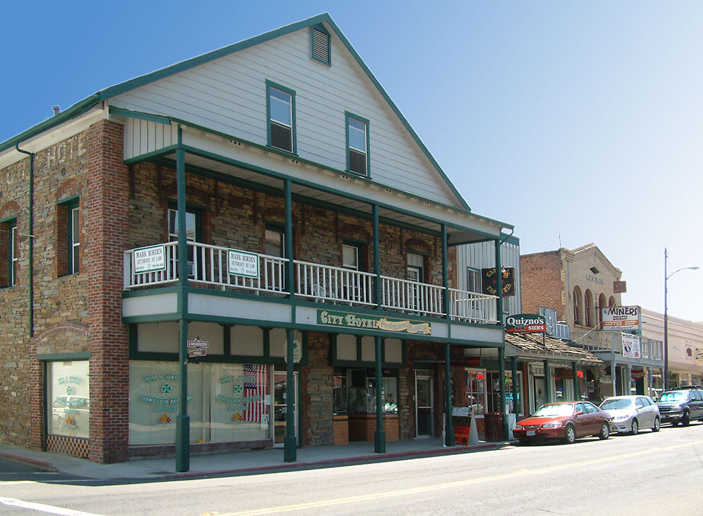
The newspaper of record for the Sonora area is The Union Democrat.
The Tuolumne County Film Commission describes Sonora as "one of the country's most versatile locations", where more than "300 film[s] and television series" have been made.
Local museums depict the Gold Rush era and historic Sonora.
The small town is home to the professional theatre company Sierra Repertory Theatre that produces a variety of musicals and plays each year at two different theatre buildings, the East Sonora Theatre and the Fallon House Theatre in Columbia.
Sonora is also home to the Tuolumne County Arts Alliance.
The pilot, and various scenes, of the television show Little House on the Prairie was filmed in Sonora.
Notable people ==
- Vaughn Armstrong – actor
- Melvin Belli – attorney
- David Carkeet - writer
- Jack Cassinetto – painter
- Phil Coke – MLB pitcher
- Molly Culver - actress
- Charles Dellschau – artist
- T.J. Dillashaw - UFC Bantamweight Champion
- Ross Dwelley - NFL tight end
- Larry Franco - film producer
- James P. Hogan – writer
- Jenny O'Hara – actress
- Josh Parry - NFL fullback
- Dan Pastorini – NFL quarterback
- Francis "Rocco" Prestia - bassist of Tower of Power
- Tata Vega - Entertainer
- Kahale Warring - NFL Tight End
References
References
- "2020 U.S. Gazetteer Files". United States Census Bureau.
- "US Census Bureau".
- {{GNIS. 2411930
- "QuickFacts - Sonora city, California".
- (2007). "California History". California Historical Society.
- Herrera Canales, Inés. (2015). "Trabajadores y técnicas mineras andinas en las fiebres del oro del mundo en el siglo XIX". Nuevo Mundo.
- "A Short History - City of Sonora". City of Sonora.
- Ricapito, Giuseppe. (July 17, 2021). "Sonora Hebrew Cemetery hosts final burial for Holocaust survivor".
- Levinson, Robert E.. (1994). "The Jews in the California Gold Rush". Commission for the Preservation of Pioneer Jewish Cemeteries and Landmarks, [[Judah L. Magnes Museum]].
- Carkeet, David. (2005). "Campus Sexpot: A Memoir". University of Georgia Press.
- [[National Weather Service]] (Sacramento); [http://w2.weather.gov/climate/xmacis.php?wfo=sto NOW Data]
- "SONORA, CALIFORNIA - Climate Summary". dri.edu.
- "Sonora, California Köppen Climate Classification (Weatherbase)". Weatherbase.
- "Decennial Census by Decade".
- "1870 Census of Population - Population of Civil Divisions less than Counties - California - Almeda County to Sutter County".
- "1870 Census of Population - Population of Civil Divisions less than Counties - California - Tehama County to Yuba County".
- "1890 Census of Population - Population of California by Minor Civil Divisions".
- "1900 Census of Population - Population of California by Counties and Minor Civil Divisions".
- "1910 Census of Population - Supplement for California".
- "1920 Census of Population - Number of Inhabitants - California".
- "1930 Census of Population - Number and Distribution of Inhabitants - California".
- "1940 Census of Population - Number of Inhabitants - California".
- "1950 Census of Population - Number of Inhabitants - California".
- "1960 Census of Population - General population Characteristics - California".
- "1970 Census of Population - Number of Inhabitants - California".
- "1980 Census of Population - Number of Inhabitants - California".
- "1990 Census of Population - Population and Housing Unit Counts - California".
- "2000 Census of Population - Population and Housing Unit Counts - California".
- "2010 Census of Population - Population and Housing Unit Counts - California".
- "Sonora city, California; DP1: Profile of General Population and Housing Characteristics - 2020 Census of Population and Housing".
- "Sonora city, California; P16: Household Type - 2020 Census of Population and Housing".
- "Sonora city, California; DP03: Selected Economic Characteristics - 2023 ACS 5-Year Estimates Comparison Profiles".
- "2010 Census Interactive Population Search: CA - Sonora city". U.S. Census Bureau.
- (2011). "Membership benefits". Tuolumne County Chamber of Commerce.
- Nichols, Dana M. (July 10, 2011). "Retooled lumber mill back in business". Dow Jones Local Media Group, Inc..
- "Sonora Union High - School Directory Details (CA Dept of Education)".
- "Sonora Elementary - School Directory Details (CA Dept of Education)".
- "Dario Cassina High - School Directory Details (CA Dept of Education)".
- "Sonora's City Council - City of Sonora".
- "City Administrator - City of Sonora".
- "Senate District 4".
- (November 12, 2021). "District Map - AD08 | PATTERSON".
- "California's 5th Congressional District - CA-05 Representatives & District Map".
- AbDivine, The Union Democrat. "About Us". uniondemocrat.com.
- "Home page". Tuolumne County Film Commission.
- "Sierra Repertory Theatre". sierrarep.org.
- "Imagine".
- "LITTLE HOUSE ON THE PRAIRIE Reunion {{!}} Stars in the House, Thursday, 3/18 at 8PM".
This article was imported from Wikipedia and is available under the Creative Commons Attribution-ShareAlike 4.0 License. Content has been adapted to SurfDoc format. Original contributors can be found on the article history page.
Ask Mako anything about Sonora, California — get instant answers, deeper analysis, and related topics.
Research with MakoFree with your Surf account
Create a free account to save articles, ask Mako questions, and organize your research.
Sign up freeThis content may have been generated or modified by AI. CloudSurf Software LLC is not responsible for the accuracy, completeness, or reliability of AI-generated content. Always verify important information from primary sources.
Report