From Surf Wiki (app.surf) — the open knowledge base
Sleeping Giant Provincial Park
Provincial park in Ontario, Canada

Provincial park in Ontario, Canada
| Field | Value |
|---|---|
| name | Sleeping Giant Provincial Park |
| iucn_category | II |
| iucn_ref | |
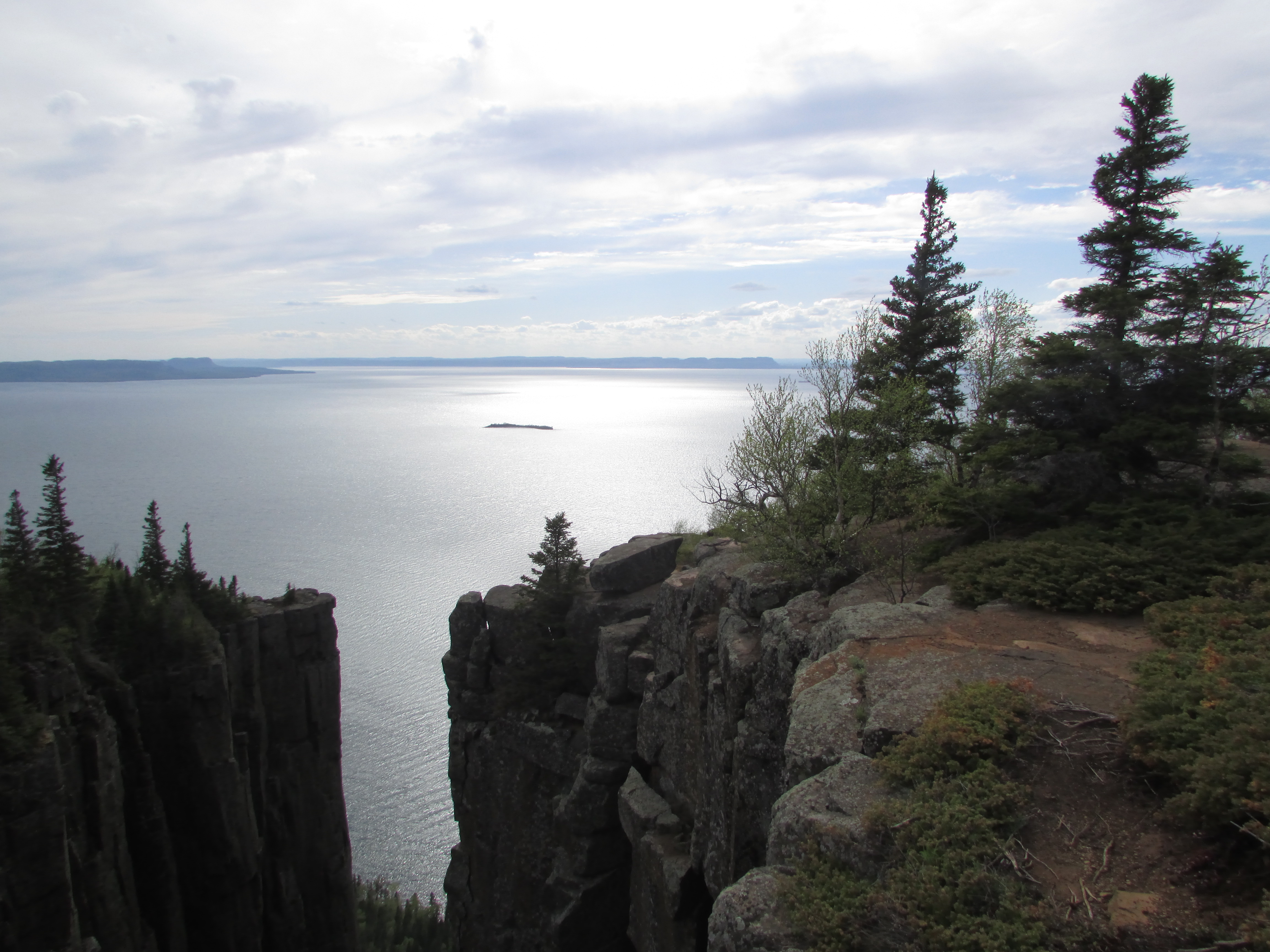
| photo | Sleeping Giant Provincial Park- Rock Formation-Sea Lion-Thunder Bay- Ontario.jpg |
| photo_caption | View overlooking the Sea Lion |
| map | Canada Ontario |
| relief | yes |
| map_caption | Location of the park in Ontario |
| location | Thunder Bay District, Ontario, Canada |
| nearest_city | Thunder Bay |
| coordinates | |
| area_km2 | 243.91 |
| area_ref | |
| established | 1944 as Sibley Provincial Park |
| visitation_num | 84,415 |
| visitation_year | 2022 |
| governing_body | Ontario Parks |
| website | |
| mapframe | yes |
| mapframe-zoom | 8 |
| mapframe-wikidata | yes |
| mapframe-zoom = 8 | mapframe-wikidata = yes
Sleeping Giant Provincial Park, established in 1944 as Sibley Provincial Park and renamed in 1988, is a 244 km2 park located on the Sibley Peninsula in Northwestern Ontario, east of Thunder Bay. The nearest communities are Pass Lake, in the township of Sibley, located at the northern entrance to the park, and Dorion, located 35 km northwest, in the township of Shuniah. The seasonal community of Silver Islet is located on the southern tip of the peninsula. The primary feature of the park is the Sleeping Giant, which is most visible from the city of Thunder Bay.
The park occupies most of the lower portion of the peninsula excluding the area around the seasonal community of Silver Islet, and a portion of Thunder Cape which is designated as the Thunder Cape Bird Observatory. The eastern portion of the park is lowlands, while the western half is composed of cliffs, valleys, and the mesa–cuestas which make up the Sleeping Giant formation. At its eastern edge, the park borders the Lake Superior National Marine Conservation Area.
Geography
The Sibley Peninsula is 52 km long and 10 km wide. It projects into Lake Superior from the north shore, separating Thunder Bay to the west and Black Bay to the east. The peninsula can be separated into two physiographic areas—highlands and lowlands. The highlands dominate the western half of the peninsula, and rise to 380 m above the surface of Lake Superior. The lowlands of the eastern portion of the peninsula rise to only 75 m, over an area 3 to 6 km wide. With the exception of diabase dikes and the large diabase sill that forms the upper portion of the Sleeping Giant, the peninsula is underlain by sedimentary rocks, which strike northeast and slope towards the southwest, forming a cuesta.
Ecology
The varied terrain and the effect of Lake Superior on the peninsula's microclimates provide habitats for a wide variety of plants and animals.
Plants found in the park include 23 species of orchids including small round-leaved orchid (Galearis rotundifolia), one of Ontario's rarest species, as well as 22 species of alpine arctic disjuncts.
Wildlife found in the park includes a wide variety of mammals. The most dominant species are white tailed deer and black bears. Close to 200 species of birds have been recorded at the park, and about 75 species are known to nest in the park. The park is also home to a few species of amphibians and reptiles, and many species of fish.
Activities
Sleeping Giant Provincial Park offers numerous recreational activities. The park has more than 100 km of trails, the longest being the 40 km Kabeyun Trail. Summer programs include guided nature walks and group campfires, and films at the park amphitheater. Other activities include boating, fishing, and cycling. The park grooms 50 km of cross-country ski trails in the winter.
Facilities
The park has several camp grounds with more than 240 camp sites. The main camp ground is at Marie Louise Lake, which has 200 camp sites, 85 of which are electric. An additional 40 camp sites are located through the park along its interior trails. The park has a picnic area and beach, and boat ramps, as well as indoor washroom and shower facilities and a laundromat. Canoes, kayaks, paddleboards, and mountain bikes can be rented from the park store.
Natural Heritage Education
Sleeping Giant Provincial Park is part of the Natural Heritage Education program. Primary interpretive themes include the Sleeping Giant formation; the geology of the park and surrounding areas; the legend about the Sleeping Giant; the transitional forest; botanical disjuncts and rarities; the history of Silver Islet; Paleo-Indian occupation of the area and subsequent pre-historic cultures; and wildlife viewing. The program is administered from the visitors centre at the Marie Louise Lake campground.
References
- Ontario Parks Sleeping Giant Background Information (2003) Queen's Printer for Ontario. . Retrieved on 26 September 2007.
References
- UNEP-WCMC. "Protected Area Profile for Sleeping Giant Provincial Park". World Database on Protected Areas.
- ''Sleeping Giant Background Information'', 2.0 Background Information, Overview, pp. 4.
- Parks, Ontario. "Ontario_Parks-Visitation-Statistics 2022 - Ministries".
- ''Sleeping Giant Background Information'', 2.0 Background Information, Figure 2 - Adjacent Land Use, pp. 6.
- ''Sleeping Giant Background Information'', 3.2 Earth Science, Topography, pp. 11.
- ''Sleeping Giant Background Information'', 3.3 Life Science, Significant Plant Communities, pps. 22–23.
- ''Sleeping Giant Background Information'', 3.3 Life Science, Wildlife, pps. 24–26.
- [http://www.ontarioparks.com/english/slee-hiking.html Sleeping Giant - Hiking] {{webarchive. link. (2012-09-07. The sum length of all trails is {{convert). 103.1. km. mi. 1. Retrieved on 26 September 2007.
- [http://www.ontarioparks.com/english/slee-facilities.html# Sleeping Giant - Facilities and Services] {{webarchive. link. (2007-10-30 . Retrieved on 26 September 2007.)
- [http://www.ontarioparks.com/english/slee-multiple.html Sleeping Giant - Park Activities] {{webarchive. link. (2007-10-30 . Retrieved on 26 September 2007.)
- ''Sleeping Giant Background Information'', 4.0 Inventory and Evaluation of Cultural Resources, interpretive Assessment and Themes, pp. 27.
This article was imported from Wikipedia and is available under the Creative Commons Attribution-ShareAlike 4.0 License. Content has been adapted to SurfDoc format. Original contributors can be found on the article history page.
Ask Mako anything about Sleeping Giant Provincial Park — get instant answers, deeper analysis, and related topics.
Research with MakoFree with your Surf account
Create a free account to save articles, ask Mako questions, and organize your research.
Sign up freeThis content may have been generated or modified by AI. CloudSurf Software LLC is not responsible for the accuracy, completeness, or reliability of AI-generated content. Always verify important information from primary sources.
Report