From Surf Wiki (app.surf) — the open knowledge base
Slave River
River in Alberta and Northwest Territories, Canada
River in Alberta and Northwest Territories, Canada
| Field | Value | ||||
|---|---|---|---|---|---|
| name | Slave River | ||||
| image | Slave River Watershed.png | ||||
| image_caption | Slave River Watershed | ||||
| source1_location | Peace-Athabasca Delta | ||||
| source1_coordinates | |||||
| mouth_location | Great Slave Lake | ||||
| mouth_coordinates | |||||
| subdivision_type1 | Country | ||||
| subdivision_name1 | Canada | ||||
| length_km | 434 | ||||
| source1_elevation | 210 m | ||||
| mouth_elevation | 160 m | ||||
| discharge1_avg | {{plainlist | ||||
| * {{convert | 3414 | m3/s | cuft/s | abbr | on}} |
| * max: {{convert | 7930 | m3/s | cuft/s | abbr | on}} |
| * min: {{convert | 543 | m3/s | cuft/s | abbr | on}} (for Fitzgerald, Alberta) |
| basin_size_km2 | 616400 |
- 3414 m3/s
- max: 7930 m3/s
- min: 543 m3/s (for Fitzgerald, Alberta) The Slave River is a Canadian river that flows from the confluence of the and Peace River in northeastern Alberta and runs into Great Slave Lake in the Northwest Territories. The river's name is thought to derive from the name for the Slavey group of the Dene First Nations, Deh Gah Gotʼine, in the Athabaskan languages. The Chipewyan had displaced other native people from this region.
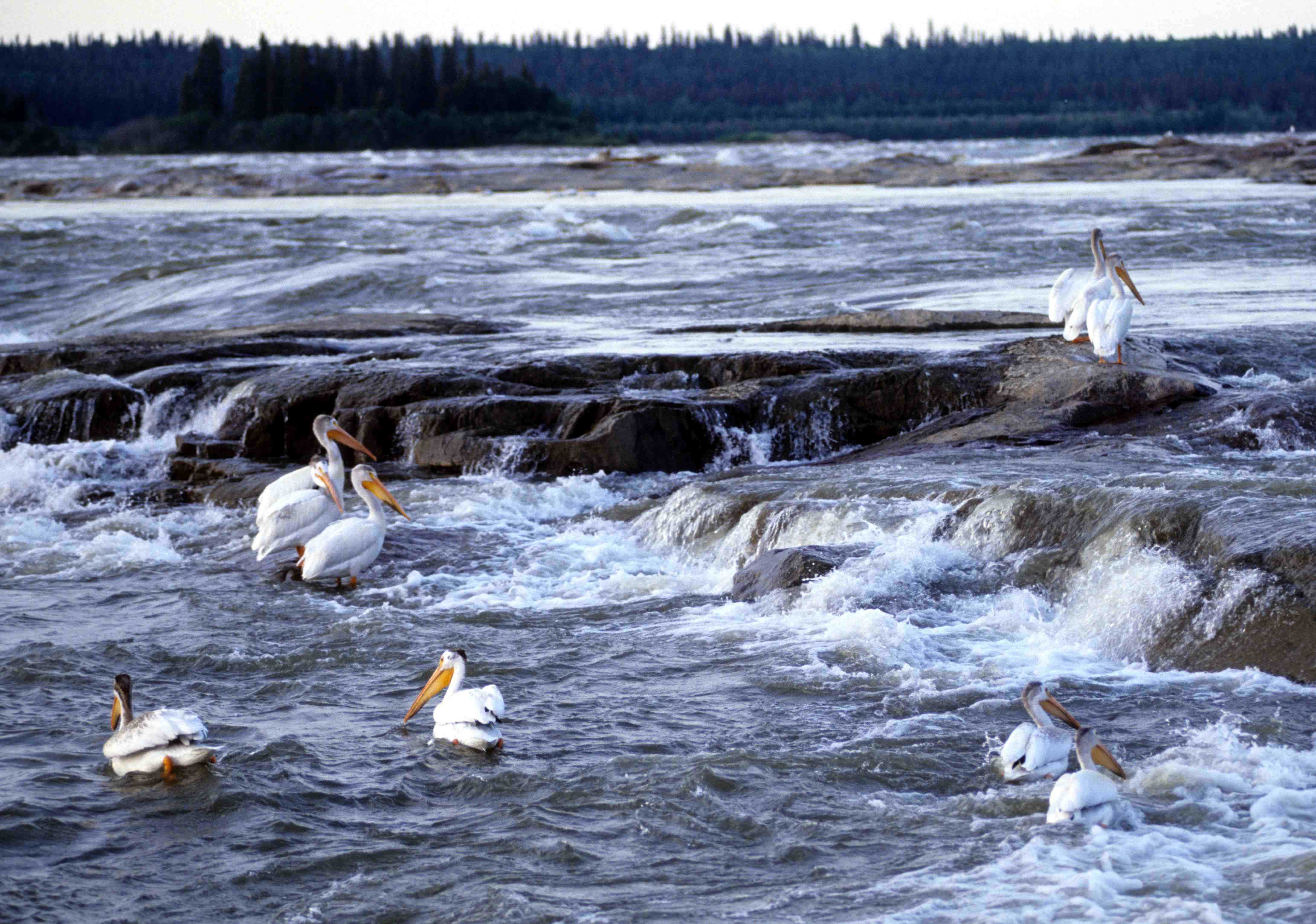
Rapids and kayaking

The Slave River and the rapids surrounding Fort Smith are known for whitewater kayaking. The river consists of four sets of named rapids: Pelican, Rapids of the Drowned, Mountain Portage, and Cassette. The rapids range in their difficulty to traverse, ranked from Class I to Class VI according to the International Scale of River Difficulty. Huge volume, massive waves, and the home of the northernmost river pelican colony in North America characterize this river. These islands serve as a sanctuary to the birds and are closed to human traffic from April 15 to September 15.
Crossing the Slave River has proven to be fatal; the earliest recorded fatalities as a part of Cuthbert Grant's expedition of 1786 at the Rapids of the Drowned (a class II-IV rapid set).
Course
The Slave River originates in the Peace-Athabasca Delta, at the forks of Peace River and , which drains the Athabasca River and Lake Athabasca. The Slave River flows north into the Northwest Territories and into the Great Slave Lake north of Fort Resolution. From there the water reaches the Arctic Ocean through the Mackenzie River.
The river is 434 km long and has a cumulative drainage area of 616400 km2.
Tributaries
- Peace-Athabasca Delta
- Athabasca River
- Lake Athabasca
- Chilloneys Creek
- Revillon Coupe
- Dempsey Creek
- Peace River
- Scow Channel
- Murdock Creek
- Darough Creek
- Powder Creek
- La Butte Creek
- Hornaday River
- Salt River
- Little Buffalo River
References
References
- [http://www.britannica.com/eb/article-9068168 Slave River]. (2006). In ''Encyclopædia Britannica''. Retrieved September 12, 2006, from Encyclopædia Britannica Premium Service
- (1989). "The English River Book: A North West Company Journal and Account Book of 1786". McGill-Queen's University Press.
- Atlas of Canada. "Rivers in Canada".
This article was imported from Wikipedia and is available under the Creative Commons Attribution-ShareAlike 4.0 License. Content has been adapted to SurfDoc format. Original contributors can be found on the article history page.
Ask Mako anything about Slave River — get instant answers, deeper analysis, and related topics.
Research with MakoFree with your Surf account
Create a free account to save articles, ask Mako questions, and organize your research.
Sign up freeThis content may have been generated or modified by AI. CloudSurf Software LLC is not responsible for the accuracy, completeness, or reliability of AI-generated content. Always verify important information from primary sources.
Report