From Surf Wiki (app.surf) — the open knowledge base
Sialkot District
District of Punjab, Pakistan
District of Punjab, Pakistan
| Field | Value |
|---|---|
| official_name | Sialkot District |
| native_name | |
| settlement_type | District of Punjab |
| image_skyline | {{Photomontage |
| size | 250 |
| photo1a | Bab_ay_Sialkot.jpg |
| photo2a | Sialkot_tower_drone_view.jpg |
| image_caption | Top: Bab-e-Sialkot (Gate of Sialkot) |
| Bottom: Sialkot tower drone view | |
| image_map | Pakistan - Punjab - Sialkot.svg |
| map_caption | Map of Sialkot District highlighted |
| subdivision_type | Country |
| subdivision_name | Pakistan |
| subdivision_type1 | Province |
| subdivision_name1 | Punjab |
| subdivision_type2 | Division |
| subdivision_name2 | Gujranwala |
| seat_type | Capital |
| seat | Sialkot |
| government_type | District Administration |
| leader_title | Deputy Commissioner |
| leader_name | Sabah asghar |
| leader_title1 | District Police Officer |
| leader_name1 | Mr faisal |
| leader_title2 | CEO Education |
| leader_name2 | mujahid elvi |
| unit_pref | Metric |
| area_total_km2 | 3016 |
| population_footnotes | |
| population_as_of | 2023 Census of Pakistan |
| population_total | 4,499,394 |
| population_density_km2 | auto |
| population_urban | 1,481,968 (32.94%) |
| population_rural | 3,017,426 (67.06%) |
| demographics2_info1 | |
| timezone1 | PST |
| utc_offset1 | +5 |
| established_title | Established |
| established_date | |
| area_code | 052 |
| blank1_name_sec1 | Number of Tehsils |
| blank1_info_sec1 | 4 |
| demographics_type1 | Language(s) |
| demographics1_footnotes | |
| demographics1_title1 | Main language(s) |
| demographics_type2 | Literacy |
| demographics2_footnotes | |
| demographics2_title1 | Literacy rate |
| demographics1_info1 | Urdu, Punjabi |
| website |
Bottom: Sialkot tower drone view
Sialkot District is a district within the Gujranwala Division of Punjab, Pakistan. Located in northeastern Punjab, the city of Sialkot is the headquarters of the district. It houses the Sialkot Cantonment, established in 1852.
Administration
The district is administratively divided into the following four tehsils (subdivisions), which contain a total of 122 Union Councils:
| # | Tehsil | Area | Pop. | Density | Lit. rate | Union Councils |
|---|---|---|---|---|---|---|
| 1 | Pasrur | 975 | 970,366 | 995.25 | 74.52% | 28 |
| 2 | Daska | 690 | 980,547 | 1,421.08 | 79.19% | 42 |
| 3 | Sambrial | 450 | 460,280 | 1,022.84 | 79.89% | 30 |
| 4 | Sialkot | 901 | 2,088,201 | 2,317.65 | 79.42% | 52 |
History
Sialkot District was an agricultural region with forests during the Indus Valley Civilization. The Vedic period is characterized by Indo-Aryan culture that flourished in the Punjab region. The Kambojas, Daradas, Kaikayas, Madras, Pauravas, Yaudheyas, Malavas and Kurus invaded, settled and ruled the ancient Punjab region. After overrunning the Achaemenid Empire in 331 BCE, Alexander marched into the present-day Punjab region with an army of 50,000. The Sialkot was ruled by Maurya Empire, the Indo-Greek kingdom, Kushan Empire, Gupta Empire, White Huns, Kushano-Hephthalites, the Arabs and Hindu Shahi kingdoms.
In 997 CE, Sultan Mahmud Ghaznavi took over the Ghaznavid dynasty empire established by his father, Sultan Sebuktegin, In 1005 he conquered the Shahis in Kabul in 1005 CE and followed this by the conquests of the Punjab region. The Delhi Sultanate and later Mughal Empire ruled the region.
At an early date the District fell to the Mughal Empire, and under the Mughals formed the Rechna Doab sarkar of the Subah of Lahore. Under Shah Jahan the sarkar was entrusted to Ali Mardan Khan, the famous engineer, who dug a canal through it to bring water from the Chenab river to the imperial gardens in Lahore.
On the decline of the Mughal Empire Ranjit Singh Deo, a Rajput hill chief, extended his sway over the lowlands, owning a nominal allegiance to Delhi. In 1748 he transferred his allegiance to Ahmad Shah Durrani, who added Zafarwal and two other parganas to his fief. Before his death in 1773 Ranjit Deo had secured possession of the whole District, except the Sialkot town and its dependencies, which were held by a Pashtun family. Sialkot district was annexed by the British from its former Sikh rulers after the Second Anglo-Sikh war of 1848–1849.
During the Indian Rebellion of 1857 the station was denuded of British troops; and the Native regiments which were left behind the rose, and, after sacking the jail, treasury, and courthouse, and massacring several of the European inhabitants, marched off towards Delhi, only to be destroyed by Nicholson at Trimmu Ghat. The rest of the Europeans took refuge in the fort, and on the morning after the departure of the rebels order was restored. The only events of interest in the subsequent history of the District are the plague riots that occurred at the villages of Shahzada and Sankhatra in 1901.
Numerous mounds are scattered about the District, which marks the sites of ancient villages and towns. None of them, except that on which the Sialkot fort stood, has been excavated, but silver and copper utensils and coins have been dug up from time to time by villagers. Most of the coins are those of Indo-Bactrian kings. The excavations in Sialkot revealed the existence of some old baths, with hot-water pipes of solid masonry. The fort itself, of which very little now remains, is not more than 1,000 years old and is said to have been rebuilt by Shahab-ud-din Ghori at the end of the twelfth century.
In 1859, Gurdaspur, Amritsar and Sialkot were placed in the new division of Sialkot. But in 1884, Gurdaspur along with Amritsar again became a part of the Lahore Division.
According to the 1901 census, the district had a population of 1,083,909 and contained 7 towns and 2,348 villages. The population at the previous three enumerations was: 1,004,695 (1868), 1,012,148 (1881) and 1,119,847 (1891). The population decreased between 1891 and 1901 by 3.2, the decrease being greatest in the Raya tahsil and least in the Daska tahsil. The Chenab Colony was responsible for this fall in population, with no less than 103,000 persons having left to take land in the newly irrigated tracts.
The district was subdivided into five tehsils, namely: Sialkot, Pasrur, Zafarwal, Raya and Daska, the headquarters of each being at the place from which it is named. The chief towns of the district were Sialkot, Daska, Jamki, Pasrur, Kila Sobha Singh, Zafarwal and Narowal.
| Tehsil | Area (sq mi) | Towns | Villages | Population (1901) | Population per sq mi | Population variation 1891–1901 | Number of literate people |
|---|---|---|---|---|---|---|---|
| Sialkot | 428 | 1 | 637 | 312,668 | 730.5 | +3.2 | 12,101 |
| Pasrur | 394 | 2 | 443 | 193,746 | 491.7 | −5.0 | 5,601 |
| Sambrial | 485 | 1 | 456 | 192,440 | 396.8 | +10.4 | 5,586 |
| Daska | 360 | 2 | 332 | 206,148 | 572.6 | −0.6 | 4,103 |
| Total | 1,991 | 7 | 2,348 | 1,083,909 | 544.4 | −3.2 | 31,341 |
In 1930, the tehsils of Raya, Daska and Pasrur were split up and parts of these were amalgamated into Gujranwala District. In 1991, the tehsils of Narowal and Shakar Garh (which was tehsil Shankar Garh of Gurdaspur district before the independence of Pakistan in 1947) were split up and formed into the new Narowal District.
Geography
Sialkot District lies southeast of Gujrat District, southwest of Jammu district (in Indian-administered Jammu and Kashmir), while Narowal District is to the southeast and Gujranwala District is situated to the west. Sialkot district is spread over an area of 3,016 square kilometers.[[File:Sunset_at_Head_Marala.jpg|thumb|right|Sunset at [[Marala Headworks|Head Marala]]]] Sialkot is hot and humid during the summer and cold during the winter. June and July are the hottest months. The maximum temperature during winter may drop to -2 C. The land is generally plain and fertile. The average annual rainfall is about 1000 mm. Over 25.82% of the population of the district is urban.
Demographics
Population
|1951 |961721 |1961 |1045958 |1972 |1509424 |1981 |1802505 |1998 |2723481 |2017 |3894938 |2023 |4499394
As of the 2023 census, Sialkot district has 671,320 households and a population of 4,499,394. The district has a sex ratio of 102.58 males to 100 females and a literacy rate of 78.37%: 80.24% for males and 76.50% for females. 1,116,259 (24.96% of the surveyed population) are under 10 years of age. 1,481,968 (32.94%) live in urban areas.
Educational Institutes
There are two main public universitiesand one medical college in Sialkot
- University of Sialkot
- Government College Women University Sialkot
- Khawaja Muhammad Safdar Medical College
There are one private university and one private medical college
- Grand Asian University Sialkot
- Islam Medical College
Besides these institutions there are many small institution providing education in District Sialkot
Religion
Muslims are the majority community making up 96.19% of the population, while Christians (descendants of Hindu Dalits who converted during the British Colonial period) are the principal minority.
| Religious | |||||||||||||||
|---|---|---|---|---|---|---|---|---|---|---|---|---|---|---|---|
| group | 1941 | 2017 | 2023 | Pop. | % | Pop. | % | Pop. | % | Total Population | 922,899 | 3,894,938 | 100% | 4,472,462 | |
| Islam [[File:Star and Crescent.svg | 15px]] | 592,236 | 3,740,507 | 96.04% | 4,302,067 | 96.19% | |||||||||
| Hinduism [[File:Om.svg | 15px]] | 176,989 | 2,870 | 0.07% | 3,195 | ||||||||||
| Sikhism [[File:Khanda.svg | 15px]] | 92,715 | 260 | ~0% | |||||||||||
| Christianity [[File:Christian cross.svg | 15px]] | 54,498 | 136,254 | 3.50% | 154,884 | 3.46% | |||||||||
| Ahmadi | 14,771 | 0.38% | 11,386 | 0.25% | |||||||||||
| Others | 6,461 | 536 | 0.01% | 668 | |||||||||||
| Note: 1941 census data is for Sialkot, Daska and Pasrur tehsils of Sialkot district, which roughly corresponds to contemporary Sialkot district. District and tehsil borders have changed since 1941. |
| Religious | ||||||||||||||||||||||||||||||||||||||||||||||
|---|---|---|---|---|---|---|---|---|---|---|---|---|---|---|---|---|---|---|---|---|---|---|---|---|---|---|---|---|---|---|---|---|---|---|---|---|---|---|---|---|---|---|---|---|---|---|
| group | 1881 | 1891 | 1901 | 1911 | 1921 | 1931 | 1941 | Pop. | % | Pop. | % | Pop. | % | Pop. | % | Pop. | % | Pop. | % | Pop. | % | Islam [[File:Star and Crescent.svg | 15px]] | Hinduism [[File:Om.svg | 15px]] | Sikhism [[File:Khanda.svg | 15px]] | Christianity [[File:Christian cross.svg | 15px]] | Jainism [[File:Jain_Prateek_Chihna.svg | 15px]] | Zoroastrianism [[File:Faravahar.svg | 15px]] | Buddhism [[File:Dharma_Wheel_(2).svg | 15px]] | Judaism [[File:Star_of_David.svg | 15px]] | Others | Total population | 1,012,148 | 1,119,847 | 1,083,909 | 979,553 | 937,823 | 979,617 | 1,190,497 |
| 669,712 | 685,342 | 716,953 | 604,801 | 580,532 | 609,633 | 739,218 | ||||||||||||||||||||||||||||||||||||||||
| 299,311 | 371,265 | 302,012 | 242,325 | 217,912 | 206,421 | 231,319 | ||||||||||||||||||||||||||||||||||||||||
| 40,195 | 49,872 | 50,982 | 81,761 | 74,939 | 94,955 | 139,409 | ||||||||||||||||||||||||||||||||||||||||
| 1,535 | 11,668 | 11,939 | 48,620 | 62,266 | 66,365 | 75,831 | ||||||||||||||||||||||||||||||||||||||||
| 1,388 | 1,696 | 2,008 | 2,029 | 2,147 | 2,236 | 3,250 | ||||||||||||||||||||||||||||||||||||||||
| 7 | 4 | 9 | 17 | 27 | 7 | 14 | ||||||||||||||||||||||||||||||||||||||||
| 0 | 0 | 6 | 0 | 0 | 0 | 3 | ||||||||||||||||||||||||||||||||||||||||
| 0 | 0 | 0 | 0 | 0 | 0 | |||||||||||||||||||||||||||||||||||||||||
| 0 | 0 | 0 | 0 | 0 | 0 | 1,453 | ||||||||||||||||||||||||||||||||||||||||
| Note1: British Punjab province era district borders are not an exact match in the present-day due to various bifurcations to district borders – which since created new districts – throughout the historic Punjab Province region during the post-independence era that have taken into account population increases. | ||||||||||||||||||||||||||||||||||||||||||||||
| Note2: Population decrease between 1901 and 1921 census due to large population migrations south to newly created tehsils and districts in the Chenab Canal Colony. |
| Tehsil | Islam [[File:Star and Crescent.svg | 15px]] | Hinduism [[File:Om.svg | 15px]] | Sikhism [[File:Khanda.svg | 15px]] | Christianity [[File:Christian cross.svg | 15px]] | Jainism [[File:Jain_Prateek_Chihna.svg | 15px]] | Others | Total | Pop. | % | Pop. | % | Pop. | % | Pop. | % | Pop. | % | Pop. | % | Pop. | % | Sialkot Tehsil | 290,469 | Pasrur Tehsil | 140,788 | Zafarwal Tehsil | 158,936 | Raya Tehsil | 196,936 | Daska Tehsil | 150,694 |
|---|---|---|---|---|---|---|---|---|---|---|---|---|---|---|---|---|---|---|---|---|---|---|---|---|---|---|---|---|---|---|---|---|---|---|---|---|
| 175,385 | 85,711 | 11,679 | 16,195 | 1,472 | 27 | |||||||||||||||||||||||||||||||
| 89,067 | 26,615 | 13,360 | 11,395 | 351 | 0 | |||||||||||||||||||||||||||||||
| 97,303 | 50,361 | 6,192 | 5,000 | 80 | 0 | |||||||||||||||||||||||||||||||
| 119,705 | 29,847 | 29,293 | 17,919 | 172 | 0 | |||||||||||||||||||||||||||||||
| 99,072 | 25,378 | 14,415 | 11,757 | 72 | 0 | |||||||||||||||||||||||||||||||
| Note: British Punjab province era tehsil borders are not an exact match in the present-day due to various bifurcations to tehsil borders – which since created new tehsils – throughout the historic Punjab Province region during the post-independence era that have taken into account population increases. |
| Tehsil | Islam [[File:Star and Crescent.svg | 15px]] | Hinduism [[File:Om.svg | 15px]] | Sikhism [[File:Khanda.svg | 15px]] | Christianity [[File:Christian cross.svg | 15px]] | Jainism [[File:Jain_Prateek_Chihna.svg | 15px]] | Others | Total | Pop. | % | Pop. | % | Pop. | % | Pop. | % | Pop. | % | Pop. | % | Pop. | % | Sialkot Tehsil | 392,764 | Pasrur Tehsil | 251,424 | Narowal Tehsil | 267,598 | Daska Tehsil | 278,711 |
|---|---|---|---|---|---|---|---|---|---|---|---|---|---|---|---|---|---|---|---|---|---|---|---|---|---|---|---|---|---|---|---|---|---|---|
| 241,505 | 104,090 | 25,306 | 17,080 | 2,797 | 1,986 | |||||||||||||||||||||||||||||
| 166,519 | 44,059 | 26,031 | 13,250 | 110 | 1,455 | |||||||||||||||||||||||||||||
| 146,982 | 54,330 | 46,694 | 19,348 | 240 | 4 | |||||||||||||||||||||||||||||
| 184,212 | 28,840 | 41,378 | 24,168 | 103 | 10 | |||||||||||||||||||||||||||||
| Note1: British Punjab province era tehsil borders are not an exact match in the present-day due to various bifurcations to tehsil borders – which since created new tehsils – throughout the historic Punjab Province region during the post-independence era that have taken into account population increases. | ||||||||||||||||||||||||||||||||||
| Note2: Tehsil religious breakdown figures for Christianity only includes local Christians, labeled as "Indian Christians" on census. Does not include Anglo-Indian Christians or British Christians, who were classified under "Other" category. |
Language
At the time of the 2023 census, 92.01% of the population spoke Punjabi, 4.86% Urdu, 1.27% Mewati and 1.22% Pashto as their first language.
Notable people
Historical figures
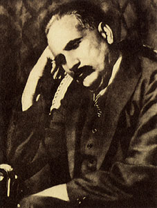
- Allama Iqbal, poet and philosopher
- Sir Muhammad Zafarullah Khan, Pakistan's first Foreign Minister and President of the United Nations General Assembly
- Faiz Ahmad Faiz,Now in Narowal District poet and scholar
- Syed Faiz-ul Hassan Shah, great orator, poet and pir, has been president of Jamiat Ulema-e-Pakistan
- Zafar Ali Khan writer, poet, and journalist who played an important role in the Pakistan Movement
- Sir Fazl-i-Hussain was one of the most Influential politicians in the United Punjab
- Ubaidullah Sindhi pre-partition Muslim Scholar and leader
- Gulzarilal Nanda, Indian politician and twice Prime Minister of India
- Umera Ahmad famous Urdu fiction writer of modern era
- Chaudhry Naseer Ahmad Malhi a leading member of the Muslim League
- Abdul Hakim Sialkoti famous Muslim intellectual of 16th century
- Chaudhry Sir Shahab-ud-Din Virk, lawyer and politician in pre-partition.
Military
- Air marshal Zafar Chaudhry was the first Chief of Air Staff
- General Khalid Shameem Wynne the 14th Chairman of the Joint Chiefs of Staff Committee
Journalists and poets
- Kuldip Nayar, Indian journalist
- Amjad Islam Amjad, Urdu writer, lyricist, and poet
- Rajinder Singh Bedi, writer
- Khalid Hasan, who was born in Srinagar but studied and lived in Sialkot.
- Hamid Mir, a Pakistani journalist who was born in Sialkot
- Abdal Bela, Urdu writer
- Taufiq Rafat, a British-Pakistani poet
Politicians
- Chaudhry Amir Hussain, former Speaker of Pakistan National Assembly, former acting President of Pakistan and Federal Minister of Pakistan 3 times
- Khawaja Muhammad Safdar, Pakistani politician and former acting President of Pakistan
- Syed Iftikhar Ul Hassan, Politician from Allo Mahar, re-elected several time as a Member of the National Assembly.
- Khawaja Muhammad Asif, politician and Federal Minister of Pakistan
- Firdous Ashiq Awan, former Federal Minister
- Mumtaz Kahloon, politician
- Gulzari Lal Nanda, former acting Indian Prime Minister
Businesspersons
- Khawaja Masood Akhtar, businessperson
- Malik Riaz, Businessperson and founder of Bahria Town
- Ansir Iqbal Baryar, Businessperson and politician
- Usman Dar, politician and businessperson
Scholars
- Pervaiz Iqbal Cheema, political scientist
Artists
- Waheed Murad, Pakistani film actor
- Rajender Kumar, Indian film actor
- A. K. Hangal, Indian film actor
- Ghulam Ali, ghazal singer
- Bilal Saeed, a Punjabi language singer and songwriter
Sportsmen
- Shoaib Malik, former captain of Pakistani cricket team
- Abdullah Shafique, Pakistani cricketer
- Ijaz Ahmed, cricketer, played for Pakistan national cricket team.
- Zaheer Abbas, Pakistani cricketer
- Abdul Rahman, Pakistani cricketer
- Shahnaz Sheikh, Pakistan national hockey team player
- Mansoor Amjad, Zahid Fazal, Pakistan national cricket team players.
- Sikandar Raza, Zimbabwean cricket player
- Jawaid Iqbal, Hong Kong national cricket player
- Nasir Ali, Pakistan national hockey team player
- Asif Bajwa, Pakistan national hockey team player
- Tariq Sheikh, Pakistan national hockey team player
- Muhammad Waqas, Pakistan national hockey team player
- Mahmood Hussain, Pakistan national hockey team player
- Maqsood Hussain, Pakistan national hockey team player
- Munir Bhatti, Pakistan national hockey team player
- Kamran Ashraf, Pakistan national hockey team player
- Haris Sohail, Pakistani cricketer
- Mukhtar Ahmed, Pakistani cricketer
Others
- Chaudhry Abdul Jalil, also known as Chacha Cricket
References
- (2023). "TABLE 1 : HOUSEHOLDS, POPULATION, HOUSEHOLD SIZE AND ANNUAL GROWTH RATE". Pakistan Bureau of Statistics.
- "TABLE 11 : POPULATION BY MOTHER TONGUE, SEX AND RURAL/URBAN, CENSUS-2023".
- "Literacy rate, enrolments, and out-of-school population by sex and rural/urban, CENSUS-2023".
- "Map of Sialkot – Government site".
- "Tehsils & Unions in the District of Sialkot".
- "TABLE 1 : AREA, POPULATION BY SEX, SEX RATIO, POPULATION DENSITY, URBAN POPULATION, HOUSEHOLD SIZE AND ANNUAL GROWTH RATE, CENSUS-2023, PUNJAB".
- "LITERACY RATE, ENROLMENT AND OUT OF SCHOOL POPULATION BY SEX AND RURAL/URBAN, CENSUS-2023".
- "Sialkot District".
- Banerjee, Abhijit. (January 2003). "History, Institutions and Economic Performance: The Legacy of Colonial Land Tenure Systems in India (BREAD Working Paper No. 003)". Bureau for Research in Economic Analysis of Development.
- "Sialkot District".
- "Population by administrative units 1951–1998". Pakistan Bureau of Statistics.
- "7th Population and Housing Census – Detailed Results: Table 1".
- "7th Population and Housing Census – Detailed Results: Table 12".
- "7th Population and Housing Census – Detailed Results: Table 5".
- "District Wise Results / Tables (Census – 2023)". [[Pakistan Bureau of Statistics]].
- "CENSUS OF INDIA, 1941 VOLUME VI PUNJAB PROVINCE".
- "Final Results (Census-2017)".
- "District Wise Results / Tables (Census – 2023)". [[Pakistan Bureau of Statistics]].
- (1881). "Census of India, 1881 Report on the Census of the Panjáb Taken on the 17th of February 1881, vol. I.".
- (1881). "Census of India, 1881 Report on the Census of the Panjáb Taken on the 17th of February 1881, vol. II.".
- (1881). "Census of India, 1881 Report on the Census of the Panjáb Taken on the 17th of February 1881, vol. III.".
- (1891). "The Punjab and its feudatories, part II—Imperial Tables and Supplementary Returns for the British Territory".
- (1901). "Census of India 1901. [Vol. 17A]. Imperial tables, I-VIII, X-XV, XVII and XVIII for the Punjab, with the native states under the political control of the Punjab Government, and for the North-west Frontier Province.".
- (1911). "Census of India 1911. Vol. 14, Punjab. Pt. 2, Tables.".
- Kaul, Harikishan. (1911). "Census Of India 1911 Punjab Vol XIV Part II".
- (1921). "Census of India 1921. Vol. 15, Punjab and Delhi. Pt. 2, Tables.".
- (1931). "Census of India 1931. Vol. 17, Punjab. Pt. 2, Tables.".
- (1941). "Census of India, 1941. Vol. 6, Punjab".
- (2023). "Population by Mother Tongue, Sex and Rural/Urban, Census-2023".
- Talbot, Ian. (16 December 2013). "Khizr Tiwana, the Punjab Unionist Party and the Partition of India". Routledge.
This article was imported from Wikipedia and is available under the Creative Commons Attribution-ShareAlike 4.0 License. Content has been adapted to SurfDoc format. Original contributors can be found on the article history page.
Ask Mako anything about Sialkot District — get instant answers, deeper analysis, and related topics.
Research with MakoFree with your Surf account
Create a free account to save articles, ask Mako questions, and organize your research.
Sign up freeThis content may have been generated or modified by AI. CloudSurf Software LLC is not responsible for the accuracy, completeness, or reliability of AI-generated content. Always verify important information from primary sources.
Report