From Surf Wiki (app.surf) — the open knowledge base
Shark Bay
Bay of the Indian Ocean in Western Australia
Bay of the Indian Ocean in Western Australia
| Field | Value |
|---|---|
| WHS | Shark Bay, Western Australia |
| image | Shark Bay Phytoplankton in Bloom.jpg |
| caption | Shark Bay |
| Location | Gascoyne region, Western Australia, Australia |
| Criteria | Natural: vii, viii, ix, x |
| ID | 578 |
| Coordinates | |
| Year | 1991 |
| Area | 2,200,902 ha |
| locmapin | Australia |
| map_caption | Location of Shark Bay at the most westerly point of the Australian continent |
| map_width | 280 |
| relief | 1 |

Shark Bay () is a World Heritage Site in the Gascoyne region of Western Australia. The 23000 km2 area is located approximately 800 km north of Perth, on the westernmost point of the Australian continent.
UNESCO's listing of Shark Bay as a World Heritage Site reads: The bay features Australia's most abundant marine ecosystems. It is a popular fishing spot.
History
The record of Australian Aboriginal occupation of Shark Bay extends to years BP. At that time most of the area was dry land, and rising sea levels flooded Shark Bay between BP and BP. A considerable number of Aboriginal midden sites have been found, especially on Peron Peninsula and Dirk Hartog Island, which provide evidence of some of the foods gathered from the waters and nearby land areas.
An expedition led by Dirk Hartog happened upon the area in 1616, becoming the second group of Europeans known to have visited Australia, after the crew of Duyfken under Willem Janszoon had visited Cape York in 1606. The area was given the name Shark Bay by the English explorer William Dampier, on 7 August 1699. Shark Bay was also visited by Louis Aleno de St Aloüarn in 1772, Nicolas Baudin from 1801 to 1803 and Louis de Freycinet in 1818. Europeans, mostly pastoralists, settled in Shark Bay during the 1860s to 1870s. Pearling developed rapidly from 1870.
Commercial whaling was conducted in the bay in the first half of the 20th century by Norwegian-owned factory ships and their catcher vessels. In the late 1930s, up to 1,000 humpback whales were taken per season.
The heritage-listed area had a population of fewer than people as at the 2011 census. The half-dozen small communities making up this population occupy less than 1% of the total area.
Climate
The Shark Bay Heritage Area has a hot desert climate under the Köppen Climate Classification, with hot, dry summers, and very mild, relatively wet winters.{{cite web |url = http://www.bom.gov.au/climate/averages/tables/cw_006105_All.shtml|title = Shark Bay Airport Climate Statistics|publisher = Bureau of Meteorology |access-date = April 1, 2024
|Jan record high C= 49.2 |Feb record high C= 49.8 |Mar record high C= 47.2 |Apr record high C= 39.9 |May record high C= 37.0 |Jun record high C= 30.7 |Jul record high C= 30.3 |Aug record high C= 35.6 |Sep record high C= 36.7 |Oct record high C= 42.8 |Nov record high C= 44.8 |Dec record high C= 46.2 |Jan record low C= 16.3 |Feb record low C= 16.5 |Mar record low C= 13.8 |Apr record low C= 10.0 |May record low C= 4.5 |Jun record low C= 3.7 |Jul record low C= 2.8 |Aug record low C= 5.0 |Sep record low C= 6.2 |Oct record low C= 7.6 |Nov record low C= 10.3 |Dec record low C= 13.2 |Jan dew point C = 16.7 |Feb dew point C = 17.4 |Mar dew point C = 14.6 |Apr dew point C = 13.1 |May dew point C = 10.1 |Jun dew point C = 8.1 |Jul dew point C = 7.7 |Aug dew point C = 6.9 |Sep dew point C = 8.3 |Oct dew point C = 10.4 |Nov dew point C = 12.3 |Dec dew point C = 14.1 |access-date = April 1, 2024
Shark Bay World Heritage Site
The World Heritage status of the region was created and negotiated in 1991, the first such site in Western Australia. The site was gazetted on the Australian National Heritage List on 21 May 2007
Protected areas
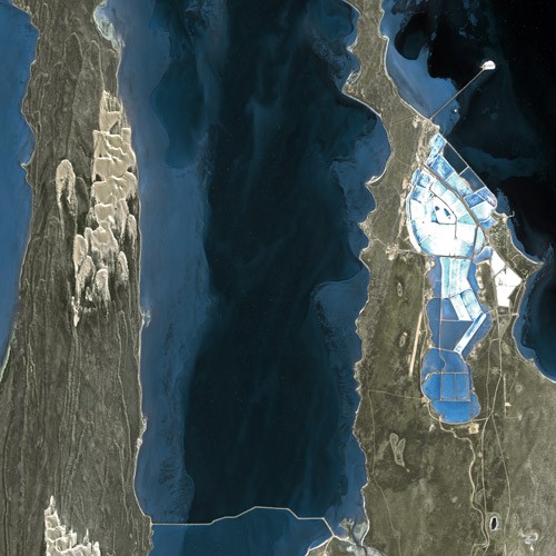
Declared as a World Heritage Site in 1991, the site covers an area of 23000 km2, of which about 70 per cent are marine waters. It includes many protected areas and conservation reserves, including Shark Bay Marine Park, Francois Peron National Park, Hamelin Pool Marine Nature Reserve, Zuytdorp Nature Reserve and numerous protected islands. Denham and Useless Loop both fall within the boundary of the site, yet are specifically excluded from it.
Landforms
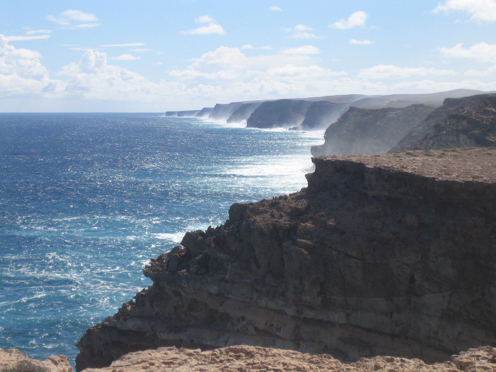
The bay itself covers an area of 1300000 ha, with an average depth of 9 m. It is divided by shallow banks and has many peninsulas and islands. The coastline is over 1500 km long. There are about 300 km of limestone cliffs overlooking the bay. One spectacular segment of cliffs is known as the Zuytdorp Cliffs. The bay is located in the transition zone between three major climatic regions and between two major botanical provinces.
Peron Peninsula divides the bay and is the home of its largest settlements as well as a National Park at the northern end.
Dirk Hartog Island is of historical significance due to landings upon it by early explorers. In 1616, Dirk Hartog landed at Inscription Point on the north end of the island and marked his discovery with a pewter plate, inscribed with the date and nailed to a post. This plate was then replaced by Willem de Vlamingh and returned to the Netherlands. It is now kept in the Rijksmuseum. The Shark Bay Discovery Centre in Denham has a replica of this plate.
Bernier and Dorre islands in the north-west corner of the heritage area are among the last-remaining habitats of two varieties of Australian mammals, hare-wallabies, threatened with extinction. They are used, with numerous other smaller islands throughout the marine park, to release threatened species that are being bred at Project Eden in François Peron National Park. These islands are free of feral non-native animals which might predate upon the threatened species, and so provide a safe haven in which to restore species that are threatened on the mainland.
In 1999 the Australian Wildlife Conservancy acquired the 5,816 ha pastoral lease over Faure Island, off Monkey Mia. Sea turtles nest there seasonally and are the subject of studies conducted in conjunction with the Department of Biodiversity, Conservation and Attractions.
Fauna
Shark Bay is an area of major zoological importance. It is home to about 10,000 dugongs ('sea cows'), around 12.5% of the world's population, and there are many Indo-Pacific bottlenose dolphins, particularly at Monkey Mia. The dolphins here have been particularly friendly since the 1960s. The area supports 26 threatened Australian mammal species, over 230 species of bird, and nearly 150 species of reptile. It is an important breeding and nursery ground for fish, crustaceans, and coelenterates. There are over 323 fish species, many of them sharks and rays.
Some bottlenose dolphins in Shark Bay exhibit one of the few known cases of tool use in marine mammals (along with sea otters): they protect their nose with a sponge while foraging for food in the sandy sea bottom. Humpback and southern right whales use the waters of the bay as migratory staging post while other species such as Bryde's whale come into the bay less frequently to feed or rest. The threatened green and loggerhead sea turtles nest on the bay's sandy beaches. The largest fish in the world, the whale shark, gathers in the bay during the April and May full moons.
Flora
Shark Bay has the largest known area of seagrass, with seagrass meadows covering over 4000 km2 of the bay.
Shark Bay also contains the largest number of seagrass species ever recorded in one place; twelve species have been found, with up to nine occurring together in some places. The seagrasses are a vital part of the complex environment of the bay. Over thousands of years, sediment and shell fragments have accumulated in the seagrasses to form vast expanses of seagrass beds. This has raised the sea floor, making the bay shallower. Seagrasses are the basis of the food chain in Shark Bay, providing home and shelter to various marine species and attracting the dugong population.
In Shark Bay's hot, dry climate, evaporation greatly exceeds the annual precipitation rate. Thus, the seawater in the shallow bays becomes very salt-concentrated, or hypersaline. Seagrasses also restrict the tidal flow of waters through the bay area, preventing the ocean tides from diluting the sea water. The water of the bay is 1.5 to 2 times more salty than the surrounding ocean waters.

Stromatolites
Based on growth rate it is believed that about 1,000 years ago cyanobacteria (blue-green algae) began building up stromatolites in Hamelin Pool at the Hamelin Station Reserve in the southern part of the bay. These microbialites, a type of sedimentary structure, are modern examples of some of the earliest signs of life on Earth, with fossilized stromatolites being found dating from 3.5billion years ago at North Pole near Marble Bar, in Western Australia, and are considered the type of fossil with the longest continuous presence in the geological record. Shark Bay's modern examples were first identified in 1956 at Hamelin Pool, before that only being known in the fossil record. They may, however, be significantly different from fossilised examples, as growth rates may be up to 250 times slower than the estimated growth rates of some Precambrian stromatolites. There is debate, however, over whether this indicates a true difference in growth rate, or if Precambrian growth estimates are instead too high.
Shark Bay World Heritage Discovery Centre
Facilities around the World Heritage area, provided by the Shire of Shark Bay and the Department of Biodiversity, Conservation and Attractions, include the Shark Bay World Heritage Discovery Centre in Denham which provides interactive displays and comprehensive information about the features of the region.
Access
Access to Shark Bay is by air via Shark Bay Airport, and by the World Heritage Drive, a 150 km link road between Denham and the Overlander Roadhouse on the North West Coastal Highway.
Specific reserved areas
National parks and reserves in the World Heritage Area

- Bernier Island
- Dorre Island
- Charlie Island
- Francois Peron National Park
- Friday Island
- Hamelin Pool Marine Nature Reserve
- Hamelin Pool/East Faure Island High-Low Water Mark
- Koks Island
- Monkey Mia
- Shark Bay Marine Park

- Shell Beach
- Small Islands
- Zuytdorp Nature Reserve
Bays of the World Heritage area
- Hamelin Pool
- Henri Freycinet Harbour
- L'Haridon Bight
Islands of the World Heritage area
- Bernier Island
- Dirk Hartog Island
- Faure Island
Peninsulas of the World Heritage area
- Bellefin Prong
- Heirisson Prong
- Carrarang Peninsula
- Peron Peninsula
IBRA sub regions of the Shark Bay Area
The Shark Bay area has three bioregions within the Interim Biogeographic Regionalisation for Australia (IBRA) system: Carnarvon, Geraldton Sandplains, and Yalgoo. The bioregions are further divided into sub-bioregions:
- Carnarvon bioregion (CAR) –
- Wooramel sub region (CAR2) – most of Peron Peninsula and coastline east of Hamelin Pool
- Cape Range sub region (CAR1) – (not represented in area)
- Geraldton Sandplains bioregion (GS) –
- Geraldton Hills sub region (GS1) – Zuytdorp Nature Reserve area
- Leseur sub region (GS2) – (not represented in area)
- Yalgoo bioregion (YAL) –
- Tallering sub region (YAL2) (not represented in area)
- Edel subregion (YAL1) – Bernier, Dorre and Dirk Hartog Islands
References
References
- (16 April 2024). "World Heritage Places - Shark Bay, Western Australia". Department of Climate Change, Energy, the Environment and Water.
- (2014). "Shark Bay, Western Australia". UNESCO World Heritage Centre.
- (13 May 2023). "Shark Bay locals fear influx of fishers to World Heritage site will harm fish stocks". [[ABC News (Australia).
- {{cite Q. Q126680180
- (1803). "A Chronological History of the Discoveries in the South Sea or Pacific Ocean". [[George Nicol (bookseller).
- (1995). "Australia's coast of coral and pearl". Seal Books.
- (12 September 1997). "Agreement between the state of Western Australia and the Commonwealth of Australia on administrative arrangements for the Shark Bay World Heritage Property in Western Australia". WA Department of Conservation and Land Management.
- (February 2020). "World Heritage and local change: Conflict, transformation and scale at Shark Bay, Western Australia". Journal of Rural Studies.
- (21 May 2007). "Determination regarding including World Heritage places in the National Heritage List". [[Department of the Environment (Australia).
- "Banded Hare-wallaby".
- (2008). "Feasibility study for the eradication of feral cats from Faure Island, Shark Bay, Western Australia". Records of the Western Australian Museum, Supplement.
- Riley, Laura and William. (2005). "Nature's Strongholds: The World's Great Wildlife Reserves". Princeton University Press.
- (22 July 2014). "Hamelin Pool Stromatolites: Ages and Interactions with the Depositional Environment". University of Miami.
- "Stromatolites of Shark Bay: Nature fact sheets". [[Government of Western Australia]].
- (1990-06-01). "Growth rates and Holocene development of stromatolites from Shark Bay, Western Australia". Australian Journal of Earth Sciences.
- Nichols, Gary. (2010). "Sedimentology and stratigraphy". Wiley-Blackwell.
- Avolio C.. (20 August 2010). "First new chlorophyll in 60 years discovered". Faculty of Science, [[The University of Sydney]].
- (2007). "Shark Bay terrestrial reserves and proposed reserve additions: draft management plan 2007". WA Department of Environment and Conservation; Conservation Commission of Western Australia.
This article was imported from Wikipedia and is available under the Creative Commons Attribution-ShareAlike 4.0 License. Content has been adapted to SurfDoc format. Original contributors can be found on the article history page.
Ask Mako anything about Shark Bay — get instant answers, deeper analysis, and related topics.
Research with MakoFree with your Surf account
Create a free account to save articles, ask Mako questions, and organize your research.
Sign up freeThis content may have been generated or modified by AI. CloudSurf Software LLC is not responsible for the accuracy, completeness, or reliability of AI-generated content. Always verify important information from primary sources.
Report