From Surf Wiki (app.surf) — the open knowledge base
Seneca, Maryland
| Field | Value | |
|---|---|---|
| official_name | Seneca, Maryland | |
| settlement_type | Unincorporated community | |
| image_alt | Small old stone building appearing to be one or two rooms. | |
| image_caption | Seneca Schoolhouse Museum in Seneca, Montgomery County, Maryland | |
| image_skyline | Seneca Schoolhouse Museum 09.jpg | |
| dot_x | dot_y = | |
| pushpin_map | Maryland#USA | |
| pushpin_label_position | top | |
| pushpin_label | Seneca | |
| pushpin_map_alt | Map of Maryland showing Seneca near Potomac River | |
| pushpin_label1 | ||
| coordinates | ||
| subdivision_type | Country | |
| subdivision_name | United States | |
| subdivision_type1 | State | |
| subdivision_name1 | Maryland | |
| subdivision_type2 | County | |
| subdivision_name2 | Montgomery | |
| established_title | Established | |
| established_title1 | ||
| established_title2 | ||
| timezone | Eastern (EST) | |
| utc_offset | -5 | |
| timezone_DST | EDT | |
| utc_offset_DST | -4 | |
| postal_code_type | ZIP code | |
| postal_code | 20834 |
Today (2020), the community uses a Poolesville ZIP code, but is part of the Darnestown census-designated place. The Seneca schoolhouse is a museum, and nearby Riley's Lock and lock house are part of the Chesapeake and Ohio Canal National Historical Park. The community is located near the Dierssen Wildlife Management Area and the McKee-Beshers Wildlife Management Area. Since 1978, Seneca and additional territory have been part of the Seneca Historic District.
History
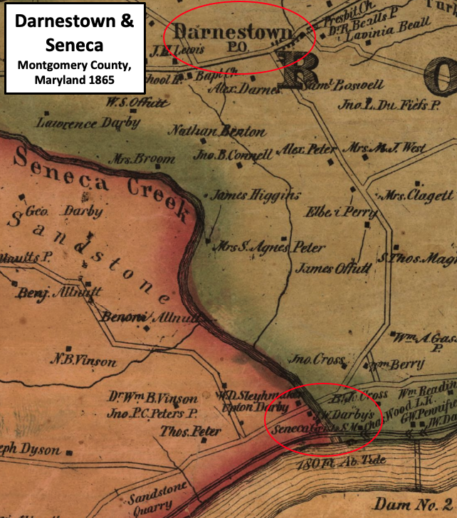
The community of Seneca exists in Montgomery County, Maryland, on Seneca Creek near the Potomac River. The creek was once very powerful, and eight of Montgomery County's 44 mills in existence before 1800 were located on this creek or its tributaries. The Seneca Mill, a gristmill, began operation around 1780, and was located on Seneca Creek close to the Potomac River.{{cite web |access-date=2020-08-11 |archive-date=2021-07-09 |archive-url=https://web.archive.org/web/20210709190004/https://mht.maryland.gov/secure/medusa/PDF/Montgomery/M;%2019-38.pdf |url-status=dead |access-date=2021-07-19 |archive-date=2021-07-19 |archive-url=https://web.archive.org/web/20210719190749/https://www.whitehousehistory.org/the-builders-of-tudor-place |url-status=live |access-date=2021-07-08 |archive-date=2022-09-09 |archive-url=https://web.archive.org/web/20220909013907/https://www.smithsonianmag.com/smithsonian-institution/the-story-behind-smithsonian-castles-red-sandstone-17818600/ |url-status=live
Construction of the Chesapeake and Ohio Canal (a.k.a. C&O Canal) along the Potomac River began on July 4, 1828.{{cite web |access-date=2020-06-28 |archive-date=2020-06-09 |archive-url=https://web.archive.org/web/20200609133726/https://www.canaltrust.org/about-us/about-the-co-canal/history/canal-history-co-canal-vs-bo-railroad/ |url-status=live |access-date=2020-07-21 |archive-date=2020-07-21 |archive-url=https://web.archive.org/web/20200721124852/https://catalog.archives.gov/id/117692021 |url-status=live |access-date=2020-05-13 |archive-date=2021-07-09 |archive-url=https://web.archive.org/web/20210709190004/https://mht.maryland.gov/secure/medusa/PDF/Montgomery/M;%2019-38.pdf |url-status=dead
Peak and decline
The American Civil War was difficult for the Peter family. Several skirmishes between Union and Confederate troops occurred nearby, including an attack in 1863 that damaged nearby canal infrastructure.{{#tag:ref|On June 27, 1863, 5,000 cavalry troops under the command of Confederate Major General James "Jeb" Stuart crossed the Potomac River near Lock 24. Intent on disrupting Union supply lines, they seized the canal between Locks 23 and 24, and damaged lock gates, drained water from the canal, and burned canal boats.{{cite web |access-date=2020-08-07 |archive-date=2020-08-06 |archive-url=https://web.archive.org/web/20200806131441/https://www.canaltrust.org/pyv/rowsers-ford/ |url-status=live |access-date=2021-07-15 |archive-date=2021-07-15 |archive-url=https://web.archive.org/web/20210715154607/http://www.montgomeryplanningboard.org/meetings_archive/03_meeting_archive/agenda_110603/item6a_110603_opt.pdf |url-status=live |access-date=2020-07-07 |archive-date=2020-08-15 |archive-url=https://web.archive.org/web/20200815151221/https://www.nps.gov/nr/travel/Wash/dc6.htm |url-status=dead |access-date=2020-08-11 |archive-date=2021-07-09 |archive-url=https://web.archive.org/web/20210709184924/https://www.dcpreservation.org/event/tour-of-historic-seneca-maryland-with-the-historical-society-of-washington-dc/ |url-status=live |access-date=2020-08-11 |archive-date=2021-05-06 |archive-url=https://web.archive.org/web/20210506065202/https://gaithersburghistory.com/tschiffely-mill-seneca-creek-potomac-river-stone-cutting.html |url-status=dead
1950s, 1960s, and today
Seneca was the location of the Mills Cross Array, once the world's largest radio telescope which, in 1955, was used to make the first observations of radio waves emitted from a planet.{{cite web |access-date=2021-07-08 |archive-date=2021-07-29 |archive-url=https://web.archive.org/web/20210729075146/https://www.nist.gov/news-events/news/2017/08/field-dreams |url-status=live |access-date=2021-07-14 |archive-date=2021-07-09 |archive-url=https://web.archive.org/web/20210709190004/https://mht.maryland.gov/secure/medusa/PDF/Montgomery/M;%2019-38.pdf |url-status=dead
In 2021, the radio telescope is gone and the site is now part of the McKee-Beshers Wildlife Management Area. A historical marker commemorating the discovery is located on River Road at the management area's parking lot. All that remains of Seneca are a few homes, the schoolhouse as a museum, the store, and ruins of the stone-cutting mill and quarry. The community is still listed by the United States Geological Survey as a populated place. https://books.google.com/books?id=8cZaAAAAYAAJ&pg=PA4&dq=Seneca,+Maryland&hl=en&newbks=1&newbks_redir=0&sa=X&ved=2ahUKEwjD-tuQg-HxAhUcEFkFHX4mAp44RhDoATAJegQIChAC#v=onepage&q=Seneca&f=false{{cite web |access-date=2020-08-18 |access-date=2020-07-16}}--
Geography

Seneca is a populated place that is not a census-designated or incorporated place having an official federally recognized name. Previous names for the community are Newport and possibly Middlebrook Mills. Seneca is located in Montgomery County, Maryland. The USGS defines a populated place as a place or area with clustered or scattered buildings and a permanent human population (city, settlement, town, village). A populated place is usually not incorporated and by definition has no legal boundaries. However, a populated place may have a corresponding "civil" record, the legal boundaries of which may or may not coincide with the perceived populated place.{{cite web |access-date=2021-07-07 |archive-date=2021-06-27 |archive-url=https://web.archive.org/web/20210627203345/https://geonames.usgs.gov/apex/f?p=138:8 |url-status=live
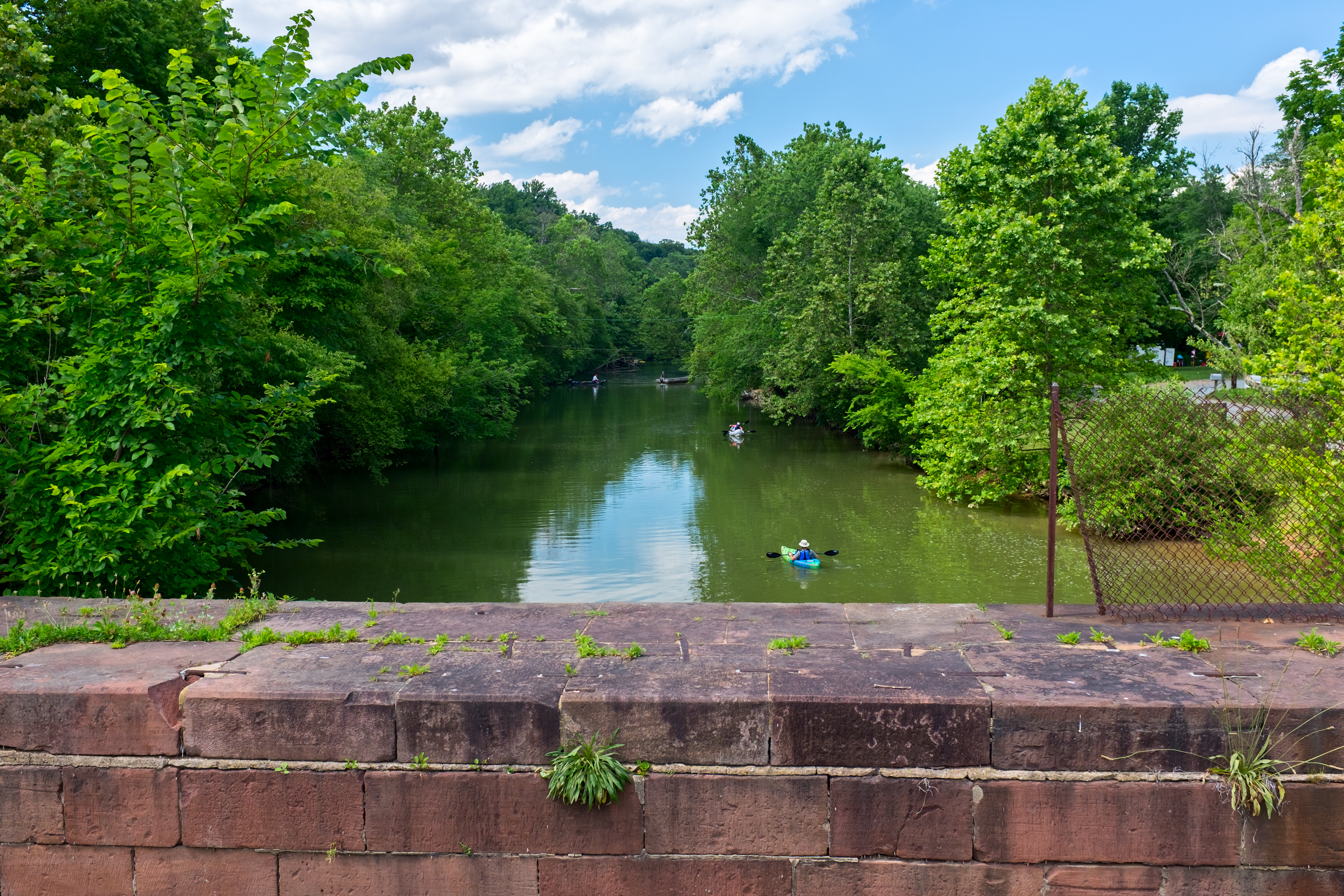
Seneca is located close to the intersection of River Road (Maryland Route 190), Seneca Road (Maryland route 112), and Rileys Lock Road, east of Great Seneca Creek and north of the Potomac River. The C&O Canal runs along the river, and Riley's Lock is the closest canal lock. The southern portion of Seneca Creek State Park is nearby, as is the Bretton Woods Golf Course.{{Cite map |archive-date = 2021-07-09 |archive-url = https://web.archive.org/web/20210709190219/https://geonames.usgs.gov/apex/gazvector.getesrimap?p_lat=39.078719&p_longi=-77.3391513&fid=587270 |url-status = live
Climate
|access-date=2021-07-08 |archive-date=2021-07-09 |archive-url=https://web.archive.org/web/20210709191431/https://www.weatherwx.com/hazardoutlook/md/poolesville.html |url-status=live
Demographics
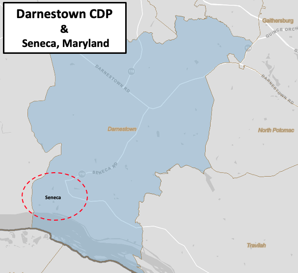
Seneca is part of the Darnestown census-designated place (CDP), an unincorporated area in Montgomery County, Maryland. The CDP is 17.70 sqmi with the Potomac River as its southern border and the Muddy Branch as much of its eastern border. Seneca Creek borders portions of its north and west sides. As of the 2010 U.S. census, the Darnestown CDP population was 6,802—and Seneca's population is a small subset of the CDP total. Total land area for the CDP was 16.39 sqmi out of a total area of 17.70 sqmi. The population density for the CDP was 415.0 PD/sqmi. The CDP had 2,275 housing units at an average density of 138.8 /mi2. These densities were much lower than county seat Rockville, where the District 4 portion had a population density of 4403.3 PD/sqmi and a housing density of 1,779.3 /mi2.
Government
Citizens of Seneca are part of District 1 of the Montgomery County Council.{{cite web |access-date=2020-03-28 |archive-date=2020-10-17 |archive-url=https://web.archive.org/web/20201017055510/https://www2.montgomerycountymd.gov/mccouncildistrict/ |url-status=live |access-date=2020-03-28 |archive-date=2020-10-17 |archive-url=https://web.archive.org/web/20201017055510/https://www2.montgomerycountymd.gov/mccouncildistrict/ |url-status=live
Infrastructure
Transportation
_at_Maryland_State_Route_112_(Seneca_Road)_in_Darnestown,_Montgomery_County,_Maryland.jpg)
Seneca's major roads are River Road (Maryland Route 190) and Seneca Road (Maryland Route 112). Three Interstate Highways are reasonably close. Maryland's Interstate 270 is a major north–south Interstate Highway for Montgomery County that connects with Washington's Capital Beltway (a.k.a. Interstate 495). Interstate 95 is a major north–south highway for the nation's east coast. Portions of the Washington Metropolitan Area Transit Authority's Metrorail system are located in Montgomery County, and Red Line stations on the west side of the county are closest to Seneca.{{cite web |access-date=2020-03-16 |archive-date=2020-03-26 |archive-url=https://web.archive.org/web/20200326000027/https://visitmontgomery.com/get-inspired/washington-dc/ |url-status=live |access-date=2020-03-16 |archive-date=2019-11-10 |archive-url=https://web.archive.org/web/20191110015544/https://www.wmata.com/schedules/maps/upload/2019-System-Map.pdf |url-status=live
Utilities
Seneca's electric power is provided by Pepco (Potomac Electric Power Company), which serves much of Montgomery County, portions of Prince George's County, and all of the District of Columbia.{{cite web |access-date=2020-05-22 |archive-date=2020-10-30 |archive-url=https://web.archive.org/web/20201030203323/https://electricityrates.com/maryland/pepco/ |url-status=live |access-date=2020-05-22 |archive-date=2020-09-30 |archive-url=https://web.archive.org/web/20200930172601/https://www.washingtongas.com/builders-contractors/contractor-services/service-territory |url-status=live |access-date=2020-05-22 |archive-date=2020-05-13 |archive-url=https://web.archive.org/web/20200513075021/https://www.montgomerycountymd.gov/SWS/facilities/ts/ |url-status=live
Healthcare
The nearest general hospital is the Adventist HealthCare Shady Grove Medical Center in Rockville.{{cite web |access-date=2020-05-22 |archive-date=2020-05-23 |archive-url=https://web.archive.org/web/20200523072703/https://www.adventisthealthcare.com/locations/profile/shady-grove-medical-center/ |url-status=live |access-date=2020-05-22 |archive-date=2020-06-06 |archive-url=https://web.archive.org/web/20200606135932/https://www.adventisthealthcare.com/news/2020/shady-grove-medical-center-earns-five-star-rating/ |url-status=live |access-date=2021-07-14 |archive-date=2021-07-14 |archive-url=https://web.archive.org/web/20210714195320/https://www.adventisthealthcare.com/locations/ |url-status=live
Education

Seneca is served by Montgomery County Public Schools. Those that live on, or east of, Rileys Lock Road attend Darnestown Elementary, Lakelands Park Middle School, and Northwest High School. Northwest High School is located in Germantown.{{cite web |access-date=2020-08-24 |archive-date=2020-07-29 |archive-url=https://web.archive.org/web/20200729222346/https://www2.montgomeryschoolsmd.org/schools/northwesths |url-status=live |access-date=2020-08-24 |archive-date=2020-08-06 |archive-url=https://web.archive.org/web/20200806080032/https://www.butlerschool.org/ |url-status=live |access-date=2020-08-24 |archive-date=2020-09-28 |archive-url=https://web.archive.org/web/20200928093559/https://www.maryofnazareth.org/ |url-status=live |access-date=2020-08-24 |archive-date=2020-08-11 |archive-url=https://web.archive.org/web/20200811185025/https://www.senecaacademy.org/ |url-status=live |access-date=2021-07-14 |archive-date=2021-07-14 |archive-url=https://web.archive.org/web/20210714203629/https://www.bullis.org/ |url-status=live
Higher education
Montgomery College has a Germantown campus known as the Pinkney Innovation Complex for Science and Technology.{{cite web |access-date=2020-08-24 |archive-date=2020-08-05 |archive-url=https://web.archive.org/web/20200805190140/https://www.montgomerycollege.edu/about-mc/campuses-and-locations/germantown-campus/index.html |url-status=live |access-date=2020-03-17 |archive-date=2020-03-14 |archive-url=https://web.archive.org/web/20200314141647/https://www.montgomerycollege.edu/ |url-status=live |access-date=2020-03-17 |archive-date=2020-03-11 |archive-url=https://web.archive.org/web/20200311204802/https://shadygrove.umd.edu/about-usg |url-status=live |access-date=2020-03-19 |archive-date=2019-08-29 |archive-url=https://web.archive.org/web/20190829031506/https://shadygrove.umd.edu/sites/default/files/u80/USG%20At%20A%20Glance%20-%20Executive%20Flyer.pdf |url-status=live |access-date=2020-03-25 |archive-date=2020-03-28 |archive-url=https://web.archive.org/web/20200328153742/http://mcc.jhu.edu/ |url-status=live
Public library
Two libraries, part of the Montgomery County Public Library system, are located less than 10 mi from Seneca. Poolesville Library, also known as Maggie Nightingale Library, is northwest of Seneca in Poolesville.{{cite web |access-date=2021-07-08 |archive-date=2021-07-09 |archive-url=https://web.archive.org/web/20210709190608/https://www.montgomerycountymd.gov/Library/branches/nightingale.html |url-status=live |access-date=2020-05-22 |archive-date=2020-05-25 |archive-url=https://web.archive.org/web/20200525082237/https://shadygrove.umd.edu/library |url-status=live |access-date=2020-03-17 |archive-date=2020-09-29 |archive-url=https://web.archive.org/web/20200929100647/https://discoverusg.org/2019/05/10/students-alumni-the-priddy-library-is-here-to-help-you-guest-post-franklin-ofsthun-library-services-specialist/ |url-status=live
Culture
Arts
The Seneca Schoolhouse Museum provides tours to schoolchildren so that they can experience a typical school day as it would have been on March 13, 1880. Glenstone Modern Art Museum is about six miles east of Seneca near the intersection of Travilah Road and Glen Road.{{cite web |access-date=2020-05-31 |archive-date=2020-05-31 |archive-url=https://web.archive.org/web/20200531210913/https://www.glenstone.org/ |url-status=live |access-date=2020-04-05 |archive-date=2020-06-09 |archive-url=https://web.archive.org/web/20200609172423/https://www.washingtonpost.com/goingoutguide/museums/going-to-glenstone-heres-what-you-need-to-know-about-dcs-new-must-see-art-museum/2018/10/02/92a29468-c00f-11e8-9005-5104e9616c21_story.html |url-status=live |access-date=2020-05-22
Recreation

Seneca Creek State Park is an irregular-shaped park of 6300 acre that follows Seneca Creek for 14 mile to the Potomac River. The park has 50 mile of trails for hiking, horseback riding and biking.{{cite web |access-date=2020-05-19 |archive-date=2020-06-24 |archive-url=https://web.archive.org/web/20200624221833/https://dnr.maryland.gov/publiclands/Pages/central/seneca.aspx |url-status=live |access-date=2020-04-14 |archive-date=2020-04-16 |archive-url=https://web.archive.org/web/20200416095614/https://www.nps.gov/choh/index.htm |url-status=live |access-date=2020-09-02 |archive-date=2020-09-26 |archive-url=https://web.archive.org/web/20200926061314/https://www.canaltrust.org/discoveryarea/rileys-lock-seneca/ |url-status=live |access-date=2020-09-02 |archive-date=2020-08-12 |archive-url=https://web.archive.org/web/20200812214650/https://www.canaltrust.org/pyv/lock-23-violettes-lock-dam-no-2/ |url-status=live |access-date=2020-09-02 |archive-date=2020-06-28 |archive-url=https://web.archive.org/web/20200628171631/https://birdersguidemddc.org/site/co-canal-pennyfield-violettes-rileys-locks/ |url-status=live |access-date=2020-08-07 |archive-date=2020-08-12 |archive-url=https://web.archive.org/web/20200812213702/https://www.canaltrust.org/pyv/dierssen-waterfowl-sanctuary/ |url-status=live |access-date=2021-07-19 |archive-date=2021-07-19 |archive-url=https://web.archive.org/web/20210719211923/https://dnr.maryland.gov/wildlife/Pages/publiclands/central/mckeebeshers.aspx |url-status=live
On the Potomac River, the Seneca Landing Special Park has a boat landing near Riley's Lock.{{cite web |access-date=2020-05-19 |archive-date=2020-11-29 |archive-url=https://web.archive.org/web/20201129111437/https://www.montgomeryparks.org/parks-and-trails/seneca-landing-special-park/ |url-status=live |access-date=2020-04-16 |archive-date=2020-04-12 |archive-url=https://web.archive.org/web/20200412161524/https://www.montgomeryparks.org/parks-and-trails/blockhouse-point-conservation-park-trails/ |url-status=live |access-date=2020-05-19 |archive-date=2020-08-13 |archive-url=https://web.archive.org/web/20200813022524/https://www.montgomeryparks.org/parks-and-trails/callithea-farm-special-park/ |url-status=live |access-date=2020-03-17 |archive-date=2020-04-10 |archive-url=https://web.archive.org/web/20200410012545/https://www.montgomeryparks.org/activities/park-trails/ |url-status=live |access-date=2020-03-17 |archive-date=2020-04-17 |archive-url=https://web.archive.org/web/20200417105005/https://www.montgomeryparks.org/parks-and-trails/muddy-branch-stream-valley-park/muddy-branch-greenway-trail/ |url-status=live
Notes
Footnotes
Citations
References
- {{Cite book
- {{Cite book | access-date = 2020-08-27 | archive-date = 2020-04-07 | archive-url = https://web.archive.org/web/20200407025657/https://www.preservationmaryland.org/wp-content/uploads/2015/12/Montgomery_Story_Fall2015_Final.pdf | url-status = live
- {{Cite book | access-date = 2021-07-20 | archive-date = 2021-07-09 | archive-url = https://web.archive.org/web/20210709195225/https://www.loc.gov/resource/g3850m.gct00186/?sp=1&r=-0.439,0.112,1.783,1.217,0 | url-status = live
- {{Cite book | access-date = 2020-03-26 | archive-date = 2021-04-12 | archive-url = https://web.archive.org/web/20210412012413/https://montgomeryplanning.org/wp-content/uploads/2017/12/Places-from-the-Past-web_with_cover.pdf | url-status = live
- {{cite magazine |access-date = 2021-07-19 |archive-date = 2021-07-19 |archive-url = https://web.archive.org/web/20210719192714/http://www.candocanal.org/atp/2014-03.pdf |url-status = live
- {{Cite book
- {{Cite book | access-date = 2020-07-19 | archive-date = 2023-02-09 | archive-url = https://web.archive.org/web/20230209215517/https://books.google.com/books?id=evCCpWAUp3EC&q=history+of+darnestown+presbyterian+church&pg=PA762 | url-status = live
- {{Cite book | editor-last = Scott | editor-first = Robert N. | access-date = 2021-12-04 | archive-date = 2023-02-09 | archive-url = https://web.archive.org/web/20230209215517/https://books.google.com/books?id=8cZaAAAAYAAJ&dq=Seneca&pg=PA4 | url-status = live
- {{Cite book | archive-url = https://web.archive.org/web/20210307224754/https://www.census.gov/prod/cen2010/cph-2-22.pdf | url-status = dead | archive-date = 2021-03-07 | access-date = 2020-12-07
- {{Cite book | access-date = 2020-03-15 | archive-date = 2023-02-09 | archive-url = https://web.archive.org/web/20230209215517/https://books.google.com/books?id=AaE1AQAAMAAJ&q=north+potomac+highways&pg=RA2-PA45 | url-status = live
- {{Cite book
- {{Cite book
References
- {{gnis. 587270
- {{harvnb. Scharf. 1882
- {{harvnb. Peck. 2013
- {{harvnb. Kelly. Maryland-National Capital Park and Planning Commission. 2011
- {{harvnb. Scott. 1889
- {{harvnb. Peck. 2013
- {{harvnb. Boyd. 1879
- {{cite GNIS
- {{harvnb. United States Census Bureau. 2012
- {{harvnb. United States Census Bureau. 2012
- {{harvnb. United States Census Bureau. 2012
- "Darnestown, CDP, Maryland - Place Selection Map". U.S. Census Bureau, U.S. Department of Commerce.
- {{harvnb. United States Department of Transportation. Maryland Department of Transportation. 2002
- Montgomery County Public Schools (Maryland). (2021). "Address Found - 16800 River Road". Montgomery County Public Schools.
- Montgomery County Public Schools (Maryland). (2020). "Northwest HS Service Area 2021-2022". Montgomery County Public Schools Division of Capital Planning.
- {{harvnb. Welles. 2019
- {{harvnb. Zdravkovska. 2011
- Sheir, Rebecca. (2015-03-20). "Kids Live History At One-Room Seneca Schoolhouse In Maryland".
- "Seneca Schoolhouse".
This article was imported from Wikipedia and is available under the Creative Commons Attribution-ShareAlike 4.0 License. Content has been adapted to SurfDoc format. Original contributors can be found on the article history page.
Ask Mako anything about Seneca, Maryland — get instant answers, deeper analysis, and related topics.
Research with MakoFree with your Surf account
Create a free account to save articles, ask Mako questions, and organize your research.
Sign up freeThis content may have been generated or modified by AI. CloudSurf Software LLC is not responsible for the accuracy, completeness, or reliability of AI-generated content. Always verify important information from primary sources.
Report