From Surf Wiki (app.surf) — the open knowledge base
Sea of Okhotsk
Marginal sea of the Pacific Ocean
Marginal sea of the Pacific Ocean
| Field | Value |
|---|---|
| name | Sea of Okhotsk |
| image | Sea of Ochotsk 151.75790E 53.57880N.jpg |
| caption | Sea of Okhotsk |
| image_bathymetry | Sea of Okhotsk map with state labels.png |
| caption_bathymetry | Map of the Sea of Okhotsk |
| location | North Asia and East Asia |
| coords | |
| type | Sea |
| basin_countries | Japan and Russia |
| area | 1583000 km2 |
| depth | 859 m |
| max-depth | 3372 m |
| max-depth = 3372 m The Sea of Okhotsk is a marginal sea of the northwestern Pacific Ocean. It is located between Russia's Kamchatka Peninsula on the east, the Kuril Islands on the southeast, Japan's island of Hokkaido on the south, the island of Sakhalin along the west, and a stretch of eastern Siberian coast along the west and north. Its northeast corner is the Shelikhov Gulf. The sea is named for the port of Okhotsk, itself named for the Okhota River.
Geography

The Sea of Okhotsk covers an area of 1,583,000 km2, with a mean depth of 859 m and a maximum depth of 3372 m. It is connected to the Sea of Japan on either side of Sakhalin: on the west through the Sakhalin Gulf and the Gulf of Tartary; on the south through the La Pérouse Strait.
In winter, navigation on the Sea of Okhotsk is impeded by ice floes. Ice floes form due to the large amount of freshwater from the Amur River, lowering the salinity of upper levels, often raising the freezing point of the sea surface. The distribution and thickness of ice floes depend on many factors: the location, the time of year, water currents, and the sea temperatures.
Cold air from Siberia forms sea ice in the northwestern Sea of Okhotsk. As the ice forms, it expels salt into the deeper layers. This heavy water flows east toward the Pacific, carrying oxygen and nutrients, supporting abundant sea life. The Sea of Okhotsk has warmed in some places by as much as 3°C (5.4°F) since preindustrial times, three times faster than the global mean. Warming inhibits the formation of sea ice and also drives fish populations north. The salmon catch on the northern Japanese coast has fallen 70% in the last 15 years, while the Russian chum salmon catch has quadrupled.
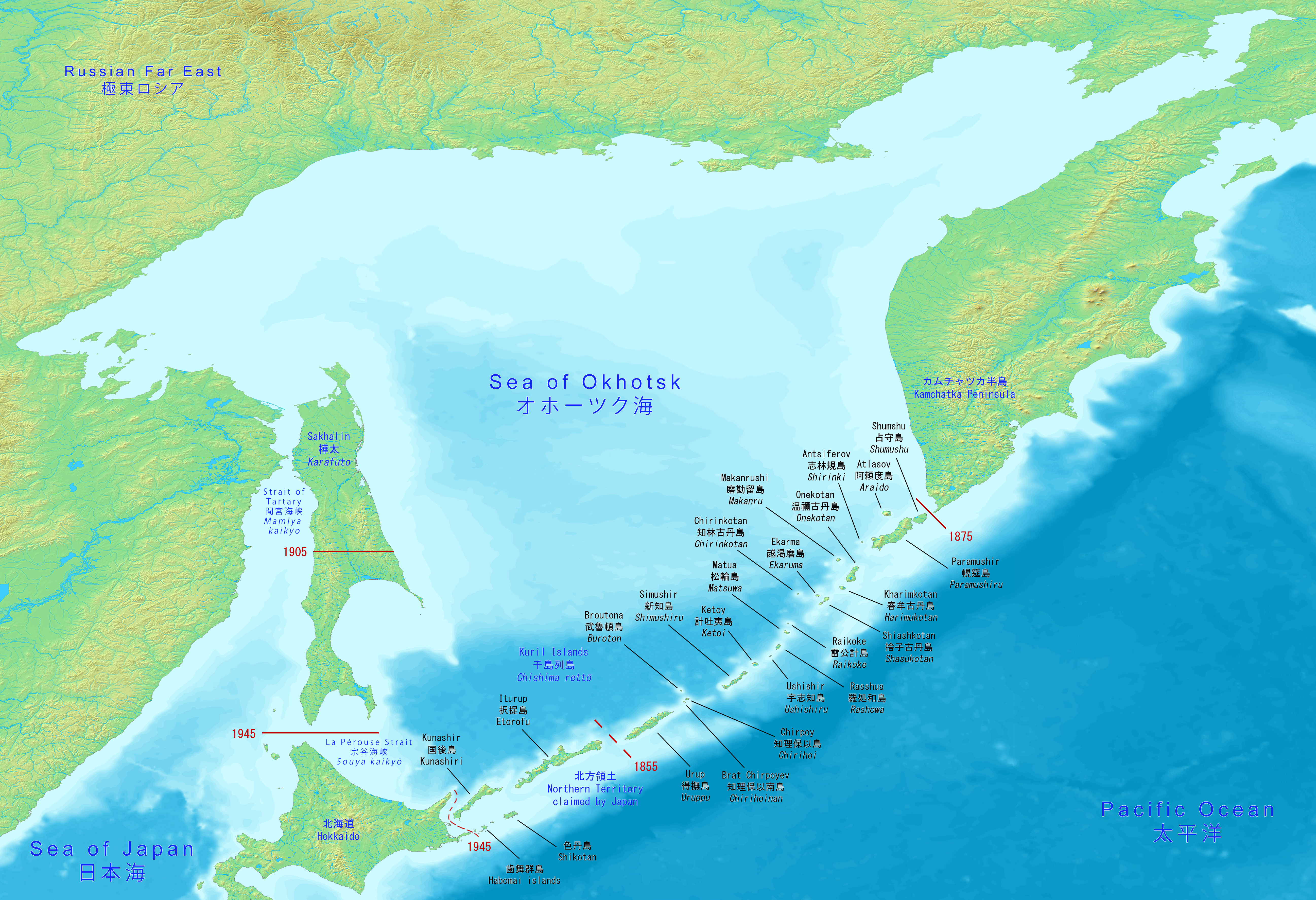
With the exception of Hokkaido, one of the Japanese home islands, the sea is surrounded on all sides by territory administered by the Russian Federation. South Sakhalin and the Kuril Islands were administered by Japan until 1945. Japan claims the southern Kuril Islands and refers to them as Northern Territories. File:Freezing the waters of the Sea of Okhotsk. Magadan.jpg|Nagayevo Bay near Magadan, Russia File:Shiretoko National Park.jpg|Shiretoko National Park on the Sea of Okhotsk coast of Hokkaido, Japan
Extent
The International Hydrographic Organization defines the limits of the Sea of Okhotsk as follows:
Islands
Some of the Sea of Okhotsk's islands are quite large, including Japan's second-largest island, Hokkaido, as well as Russia's largest island, Sakhalin. Practically all of the sea's islands are either in coastal waters (such as the Shantar Islands) or belong to the various islands making up the Kuril Islands chain. These fall either under undisputed Japanese or Russian ownership or disputed ownership between Japan and Russia. Iony Island is the only island located in open waters and belongs to the Khabarovsk Krai of the Russian Federation.
The majority of the sea's islands are uninhabited, making them ideal breeding grounds for seals, sea lions, seabirds, and other sea island fauna. Large colonies of crested auklets use the Sea of Okhotsk as a nesting site.
History

Pre-modern
The Okhotsk culture and the later Ainu people, a coastal fishing and hunter-gatherer people, were located around the lands surrounding the Sea of Okhotsk, as well as in northern Japan.
European exploration and settlement
Russian explorers Vassili Poyarkov (1639) and Ivan Moskvitin (1645) were the first Europeans to visit the Sea of Okhotsk, and probably the island of Sakhalin in the 1640s.{{citation|first=John J. |last=Stephan|publisher=Clarendon Press |year=1971
The first and foremost Russian settlement on the shore was the port of Okhotsk, which relinquished commercial supremacy to Ayan in the 1840s. The Russian-American Company all but monopolized the commercial navigation of the sea in the first half of the 19th century.
The Second Kamchatka Expedition under Vitus Bering systematically mapped the entire coast of the sea, starting in 1733. Jean-François de Galaup, comte de Lapérouse and William Robert Broughton were the first non-Russian European navigators known to have passed through these waters other than Vries. Ivan Krusenstern explored the eastern coast of Sakhalin in 1805. Mamiya Rinzō and Gennady Nevelskoy determined that Sakhalin was indeed an island separated from the mainland by a narrow strait. The first detailed summary of the hydrology of the Sea of Okhotsk was prepared and published by Stepan Makarov in 1894.
Fishing
The Sea of Okhotsk is rich in biological resources, with various kinds of fish, shellfish and crabs.
The harsh conditions of crab fishing in the Sea of Okhotsk are the subject of the most famous novel of the Japanese writer Takiji Kobayashi, The Crab Cannery Ship (1929).
The Peanut Hole
Main article: Peanut Hole
The Peanut Hole (named for its shape) is an area of open ocean at the center of the Sea of Okhotsk, about 55 km wide and 480 km long, surrounded by Russia's exclusive economic zone (EEZ). Since the Peanut Hole is not in the Russian EEZ, any country could fish there, and some began doing so in large numbers in 1991, catching perhaps as much as one million metric tons of pollock in 1992. This was seen by the Russian Federation as presenting a danger to Russian fish stocks, since the fish move in and out of the Peanut Hole from the Russian EEZ.
The Russian Federation petitioned the United Nations to declare the Peanut Hole to be part of Russia's continental shelf. In November 2013, a United Nations subcommittee accepted the Russian argument, and in March 2014 the full United Nations Commission on the Limits of the Continental Shelf ruled in favor of the Russian Federation.
Whaling
Bowhead whales were first caught in 1847, and dominated the catch between 1852 and the late 1860s. Between 1850 and 1853 the majority of the fleet went to the Bering Strait region to hunt bowheads, but intense competition, poor ice conditions, and declining catches forced the fleet back to the Sea of Okhotsk. From 1854 to 1856, an average of over 160 vessels cruised in the sea each year. As catches declined between 1858 and 1860 the fleet shifted back to the Bering Strait region.
The Russian military marine mammal program reportedly sources some of its animals from the Sea of Okhotsk.
Modern
South Sakhalin was administered by Japan as Karafuto Prefecture from 1907 to 1949. The Kuril Islands were Japanese from 1855 and 1875 till the end of World War II in 1945. Afterward, the Soviet Union occupied the territory.
During the Cold War, the Sea of Okhotsk was the scene of several successful U.S. Navy operations (including Operation Ivy Bells) to tap Soviet Navy undersea communications cables. These operations were documented in the 1998 book Blind Man's Bluff: The Untold Story of American Submarine Espionage. The sea (and surrounding area) were also the scene of the Soviet attack on Korean Air Lines Flight 007 in 1983. The Soviet Pacific Fleet used the sea as a ballistic missile submarine bastion, a strategy that Russia continues.
Despite its proximity to Japan, the Sea of Okhotsk has no native etymology in the Japanese language; its name, Ohōtsuku-kai (オホーツク海), is a transcription of the Russian name. This is also reflected in the name of Hokkaido's Okhotsk Subprefecture, which faces the Sea of Okhotsk and is also known as the Okhotsk region.
Oil and gas exploration
Twenty-nine zones of possible oil and gas accumulation have been identified on the Sea of Okhotsk shelf, which runs along the coast. Total reserves are estimated at 3.5 billion tons of equivalent fuel, including 1.2 billion tons of oil and 1.5 billion cubic meters of gas.
On 18 December 2011, the Russian oil drilling rig Kolskaya{{cite web | archive-url = https://web.archive.org/web/20120103132847/http://www.rigzone.com/data/rig_detail.asp?rig_id=521 | archive-date = 2012-01-03 | url-status = dead
Notable seaports
- Magadan, Magadan, Russia; population: 95,000
- Palana, Kamchatka, Russia; population: 3,000
- Abashiri, Hokkaido, Japan; population: 38,000
- Monbetsu, Hokkaido, Japan; population: 25,000
- Wakkanai, Hokkaido, Japan; population: 38,000
Explanatory notes
References
References
- (June 2009). "Carbon and Nutrient Fluxes in Continental Margins: A Global Synthesis". Springer.
- Everett-Heath, John. (2020). "Concise Oxford Dictionary of World Place Names". Oxford University Press.
- "Sea of Okhotsk ecology {{!}} EBSCO Research Starters".
- (2021-03-18). "Sea of Okhotsk".
- "Sea of Okhotsk - Economic aspects".
- (2004). "Thermohaline effects of the seasonal sea ice cover in the Sea of Okhotsk". Journal of Geophysical Research: Oceans.
- (2014-08-01). "Biogeochemical and physical processes in the Sea of Okhotsk and the linkage to the Pacific Ocean". Progress in Oceanography.
- "How climate change is triggering a chain reaction that threatens the heart of the Pacific". Washington Post.
- Bruce A. Elleman, Michael R. Nichols and Matthew J. Ouimet, ''A Historical Reevaluation of America's Role in the Kuril Islands Dispute'', Pacific Affairs, Vol. 71, No. 4 (Winter, 1998–1999), pp. 489–504
- (1953). "Limits of Oceans and Seas". [[International Hydrographic Organization]].
- "ウェブマガジン カムイミンタラ ~北海道の風土・文化誌 :オホーツク文化人とモヨロ貝塚 網走 流氷とともにやってきた古代民族の謎とロマンに魅せられた父子三代と研究者たち".
- {{ill. Pavel Ushakov (hydrobiologist). ru
- (1771). "[[:s:EB1". [[Colin Macfarquhar]].
- Vaughan, R. (1984). "Historical survey of the European whaling industry". In ''Arctic Whaling: Proceedings of the International Symposium'', pp. 121-145. University of Groningen.
- Bockstoce, John. (1986). "Whales, Ice, & Men: The History of Whaling in the Western Arctic". University of Washington Press.
- Jabr, Ferris. (2024-01-04). "The Whale Who Went AWOL". New York Times.
- Acharya, Amitav. (March 1988). "The United States Versus the USSR in the Pacific: Trends in the Military Balance". [[Institute of Southeast Asian Studies]].
- "Magadan Region". [[Kommersant]], Russia's Daily Online.
- [http://www.amngr.ru/index.php/en/services/fleet/kolskaya Technical details of the rig] {{Webarchive. link. (2011-02-02 ''www.amngr.ru'')
- (December 18, 2011). "Russian oil rig sinks, leaving many missing". [[CNN]].
- "Kolskaya Sinks Offshore Russia". Rigzone.
- (December 18, 2011). "Blog Archive » Rig Kolskaya Lost". Shipwreck Log.
This article was imported from Wikipedia and is available under the Creative Commons Attribution-ShareAlike 4.0 License. Content has been adapted to SurfDoc format. Original contributors can be found on the article history page.
Ask Mako anything about Sea of Okhotsk — get instant answers, deeper analysis, and related topics.
Research with MakoFree with your Surf account
Create a free account to save articles, ask Mako questions, and organize your research.
Sign up freeThis content may have been generated or modified by AI. CloudSurf Software LLC is not responsible for the accuracy, completeness, or reliability of AI-generated content. Always verify important information from primary sources.
Report