From Surf Wiki (app.surf) — the open knowledge base
Scotts Bluff County, Nebraska
County in Nebraska, United States
County in Nebraska, United States
| Field | Value |
|---|---|
| county | Scotts Bluff County |
| state | Nebraska |
| founded | 1888 |
| seat wl | Gering |
| largest city wl | Scottsbluff |
| area_total_sq_mi | 745 |
| area_land_sq_mi | 739 |
| area_water_sq_mi | 6.0 |
| area percentage | 0.8% |
| census yr | 2020 |
| pop | 36084 |
| pop_est_as_of | 2022 |
| population_est | 35603 |
| density_sq_mi | auto |
| time zone | Mountain |
| web | www.scottsbluffcounty.org/ |
| ex image | Scotts Bluff County courthouse from E 1.JPG |
| ex image cap | Scotts Bluff County Courthouse in Gering |
| district | 3rd |
| named for | Scotts Bluff |
Scotts Bluff County is a county on the western border of the U.S. state of Nebraska. As of the 2020 United States census, the population was 36,084. Its county seat is Gering, and its largest city is Scottsbluff. Scotts Bluff County is included in the Scottsbluff, NE Micropolitan Statistical Area. In the Nebraska license plate system, Scotts Bluff County is represented by the prefix 21, since the county had the twenty-first-largest number of registered vehicles registered when the state's license-plate system was established in 1922.
History
The county is named for a prominent bluff that served as a landmark for 19th-century pioneers traveling along the Oregon Trail. Scotts Bluff was named for Hiram Scott, a Rocky Mountain Fur Company trapper who died nearby around 1828. Washington Irving claimed that, after being injured and abandoned, Scott had crawled sixty miles only to perish near the bluff that now bears his name. The bluff is now managed by the National Park Service as Scotts Bluff National Monument.
The town of Gering was founded at the base of the bluff in 1887, and the city of Scottsbluff was founded across the North Platte River in 1900. Joined by the river, the former transportation highway, the two cities now form Nebraska's 7th-largest urban area.
Transportation
Scotts Bluff County Airport (BFF) is Nebraska's third-busiest airport in terms of passenger boardings.
Geography
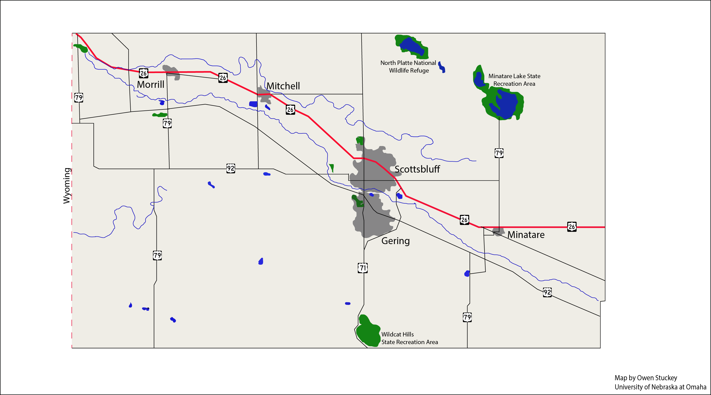
Scotts Bluff County is on the west side of Nebraska. Its west boundary line abuts the east boundary line of the state of Wyoming. The North Platte River flows east-southeastward through the upper central part of the county. The county's terrain consists of arid rolling hills, about half of which is dedicated to agriculture. The county's lands slope to the east-southeast.
The county has an area of 745 sqmi, of which 739 sqmi is land and 6.0 sqmi (0.8%) is water.
Major highways
- [[File:US 26.svg|20px]] U.S. Highway 26
- [[File:N-29.svg|20px]] Nebraska Highway 29
- [[File:N-71.svg|20px]] Nebraska Highway 71
- [[File:N-92.svg|20px]] Nebraska Highway 92
Adjacent counties
- Sioux County – north
- Box Butte County – northeast
- Morrill County – east
- Banner County – south
- Goshen County, Wyoming – west
Protected areas
- Kiowa State Wildlife Management Area
- Lake Minatare State Recreation Area
- North Platte National Wildlife Refuge
- Scotts Bluff National Monument
- Wildcat Hills State Recreation Area
Demographics
| align-fn = center 1790-1960 1900-1990 1990-2000 2010-2013 2020-2022
2020 census
As of the 2020 census, the county had a population of 36,084. The median age was 40.3 years. 24.2% of residents were under the age of 18 and 20.5% of residents were 65 years of age or older. For every 100 females there were 95.1 males, and for every 100 females age 18 and over there were 92.0 males age 18 and over.
The racial makeup of the county was 78.3% White, 0.8% Black or African American, 2.1% American Indian and Alaska Native, 0.8% Asian, 0.1% Native Hawaiian and Pacific Islander, 7.4% from some other race, and 10.5% from two or more races. Hispanic or Latino residents of any race comprised 22.7% of the population.
69.6% of residents lived in urban areas, while 30.4% lived in rural areas.
There were 14,689 households in the county, of which 29.7% had children under the age of 18 living with them and 28.1% had a female householder with no spouse or partner present. About 31.2% of all households were made up of individuals and 14.6% had someone living alone who was 65 years of age or older.
There were 16,494 housing units, of which 10.9% were vacant. Among occupied housing units, 67.4% were owner-occupied and 32.6% were renter-occupied. The homeowner vacancy rate was 1.8% and the rental vacancy rate was 14.3%.
2000 census
As of the 2000 United States census, there were 36,951 people, 14,887 households, and 10,167 families in the county. The population density was 50 /mi2. There were 16,119 housing units at an average density of 22 /mi2. The racial makeup of the county was 87.58% White, 0.27% Black or African American, 1.88% Native American, 0.57% Asian, 0.04% Pacific Islander, 8.02% from other races, and 1.63% from two or more races. 17.19% of the population were Hispanic or Latino of any race. 39.5% were of German, 8.6% English and 6.8% Irish ancestry.
There were 14,887 households, out of which 31.50% had children under the age of 18 living with them, 54.20% were married couples living together, 10.70% had a female householder with no husband present, and 31.70% were non-families. 27.80% of all households were made up of individuals, and 12.80% had someone living alone who was 65 years of age or older. The average household size was 2.44 and the average family size was 2.97.
The county population contained 25.90% under the age of 18, 8.40% from 18 to 24, 25.40% from 25 to 44, 23.00% from 45 to 64, and 17.20% who were 65 years of age or older. The median age was 38 years. For every 100 females there were 91.20 males. For every 100 females age 18 and over, there were 88.30 males.
The median income for a household in the county was $32,016, and the median income for a family was $38,932. Males had a median income of $30,317 versus $20,717 for females. The per capita income for the county was $17,355. About 11.00% of families and 14.50% of the population were below the poverty line, including 22.00% of those under age 18 and 8.70% of those age 65 or over.
Economy
The economy of Scotts Bluff County is based on agriculture, with the primary crops being sugar beets, corn, and beans.
Communities
Cities
- Gering (county seat)
- Minatare
- Mitchell
- Terrytown
- Scottsbluff
Villages
- Henry
- Lyman
- McGrew
- Melbeta
- Morrill
Unincorporated communities
- Bradley
- Haig
Precincts
- Castle Rock
- Dewey Tabor
- East Winters Creek
- Fanning
- Ford
- Funston
- Gering
- Highland
- Kiowa
- Mitchell
- Roubadeau
- West Winters Creek
Politics
Scotts Bluff County voters have been reliably Republican for almost a century. Even Lyndon Johnson failed to win the county in his 1964 landslide, while Franklin Roosevelt only managed to win the county in his first two campaigns. As of 2024, the county has not voted for a Democratic presidential candidate since 1936. The county also is slightly conservative in gubernatiorial elections; Democrats have won the county, but never without winning the state as a whole. Some Democrats have even won governership without winning the county, such as J. James Exon and Ben Nelson.
However, Scottsbluff has been the only precinct in the Nebraska panhandle to vote Democratic at the federal level since the 1990s.
Education
School districts include:
- Banner County Public Schools
- Bayard Public Schools
- Gering Public Schools
- Minatare Public Schools
- Mitchell Public Schools
- Morrill Public Schools
- Scottsbluff Public Schools
References
References
- "State & County QuickFacts". [[United States Census Bureau]].
- "Find a County". National Association of Counties.
- "The Life and Legend of Hiram Scott". National Park Service.
- (1837). "The Adventures of Captain Bonneville".
- [https://www.google.com/maps/place/Scotts+Bluff+County,+NE/@41.8509139,-103.8473491,55508m/data=!3m2!1e3!4b1!4m5!3m4!1s0x876530c59ae19c95:0x3ae7c7ac9ed36fc3!8m2!3d41.8140936!4d-103.6362715 ''Scotts Bluff County NE'' Google Maps (accessed 26 January 2019)]
- [https://www.daftlogic.com/sandbox-google-maps-find-altitude.htm "Find an Altitude" Google Maps (accessed 26 January 2019)]
- (August 22, 2012). "2010 Census Gazetteer Files". US Census Bureau.
- [https://www.google.com/maps/place/Kiowa+State+Wildlife+Management+Area,+Morrill,+NE+69358/@41.9119862,-103.9381205,14z/data=!4m13!1m7!3m6!1s0x876530c59ae19c95:0x3ae7c7ac9ed36fc3!2sScotts+Bluff+County,+NE!3b1!8m2!3d41.8140936!4d-103.6362715!3m4!1s0x87656992a353dff9:0x131e0dc8199f680b!8m2!3d41.9227122!4d-103.9397782 ''Kiowa State Wildlife Management Area, Morrill NE'' Google Maps (accessed 26 January 2019)]
- [https://www.google.com/maps/place/Lake+Minatare+State+Recreation+Area/@41.9347831,-103.5556723,12.96z/data=!4m13!1m7!3m6!1s0x876530c59ae19c95:0x3ae7c7ac9ed36fc3!2sScotts+Bluff+County,+NE!3b1!8m2!3d41.8140936!4d-103.6362715!3m4!1s0x877ab258c9265ac7:0x92b4afe6d945947b!8m2!3d41.9310815!4d-103.4743023 ''Lake Minatare State Recreation Area'' Google Maps (accessed 26 January 2019)]
- [https://www.google.com/maps/place/Wildcat+Hills+State+Recreation+Area/@41.7780612,-103.7786754,12.5z/data=!4m13!1m7!3m6!1s0x876530c59ae19c95:0x3ae7c7ac9ed36fc3!2sScotts+Bluff+County,+NE!3b1!8m2!3d41.8140936!4d-103.6362715!3m4!1s0x876ff8e470110e4f:0x15630dadaa9cd69f!8m2!3d41.7079072!4d-103.678236 ''Wildcat Hills State Recreation Area'' Google Maps (accessed 26 January 2019)]
- "US Decennial Census". US Census Bureau.
- "Historical Census Browser". University of Virginia Library.
- "Population of Counties by Decennial Census: 1900 to 1990". US Census Bureau.
- "Census 2000 PHC-T-4. Ranking Tables for Counties: 1990 and 2000". US Census Bureau.
- (July 1, 2022). "QuickFacts".
- (2021). "2020 Decennial Census Demographic Profile (DP1)".
- (2021). "2020 Decennial Census Redistricting Data (Public Law 94-171)".
- (2023). "2020 Decennial Census Demographic and Housing Characteristics (DHC)".
- "U.S. Census website". US Census Bureau.
- [http://uselectionatlas.org/RESULTS Election Results]
- Geography Division. (January 14, 2021). "2020 CENSUS - SCHOOL DISTRICT REFERENCE MAP: Scotts Bluff County, NE". [[U.S. Census Bureau]].
This article was imported from Wikipedia and is available under the Creative Commons Attribution-ShareAlike 4.0 License. Content has been adapted to SurfDoc format. Original contributors can be found on the article history page.
Ask Mako anything about Scotts Bluff County, Nebraska — get instant answers, deeper analysis, and related topics.
Research with MakoFree with your Surf account
Create a free account to save articles, ask Mako questions, and organize your research.
Sign up freeThis content may have been generated or modified by AI. CloudSurf Software LLC is not responsible for the accuracy, completeness, or reliability of AI-generated content. Always verify important information from primary sources.
Report