From Surf Wiki (app.surf) — the open knowledge base
Scotland County, North Carolina
County in North Carolina, United States
.jpg)
County in North Carolina, United States
| Field | Value |
|---|---|
| county | Scotland County |
| state | North Carolina |
| ex image | Scotland County Courthouse (February 2023) 5 (cropped).jpg |
| ex image cap | Scotland County Courthouse |
| seal | Scotland County Seal.png |
| founded date | February 20, 1899 |
| named for | Scotland |
| seat wl | Laurinburg |
| largest city wl | Laurinburg |
| city type | community |
| area_total_sq_mi | 320.62 |
| area_land_sq_mi | 319.14 |
| area_water_sq_mi | 1.48 |
| area percentage | 0.46 |
| population_as_of | 2020 |
| population_total | 34174 |
| pop_est_as_of | 2024 |
| population_est | 33898 |
| population_density_sq_mi | 107.08 |
| coordinates | |
| web | www.scotlandcounty.org |
| district | 8th |
| time zone | Eastern |
| flag | Scotland County Flag.gif |
| motto | "Future Focused" |
| logo | Scotland County Logo.png |
Scotland County is a county located in the south central part of the U.S. state of North Carolina. Its county seat is and largest community is Laurinburg. The county was formed in 1899 from part of Richmond County and named in honor of the Scottish settlers who occupied the area in the 1700s. As of the 2020 census, its population was 34,174.
The area eventually comprising Scotland was originally inhabited by Native Americans and was settled by Europeans as early as the 1720s, though settling heavily increased after the American Revolutionary War. Scotland County was created out of Richmond County in 1899 largely for political reasons. The area began to industrialize at the turn of the 20th century, but suffered heavily during the Great Depression. Industrialization increased again after World War II, as agriculture mechanized. In the 2000s, the county's economy suffered a major downturn due to the departure of textile manufacturers and the Great Recession. The economy continues to struggle in the area and the county regularly suffers from one of the state's highest unemployment rates.
History
Early history
The earliest residents of the land which became Scotland County were Cheraw Native Americans. Scottish Highlanders and some English Quakers began colonizing the area as early as the 1720s when it was within the British Province of North Carolina. The land encompassing Scotland County was originally under the jurisdiction of Bladen County. As North Carolina grew, its original counties were subdivided and the future Scotland portion was placed in the new Anson County. The relevant portion was then moved into the new Richmond County in 1779. Richmond County was bisected by the Sandhills, leaving the eastern portion—of future Scotland—geographically separated from the rest of the county.
More immigrants came after the American Revolutionary War, especially one large group of Highland Scots which came from the Cape Fear River. The group split and settled two areas in the county, Johns and Laurel Hill, the latter in the vicinity of the Laurel Hill Presbyterian Church, established in 1797. Laurel Hill became the first major community in the region, prospering as a post-revolution trading center. More immigrants settled the area at this time, including Germans, Welsh, English, and Ulster Scots. Enslaved Africans were also brought into the area. The Laurel Hill community largely moved south in 1861 after the Wilmington, Charlotte and Rutherford Railroad laid a line through the area. Gaelic was spoken in the area through the 1860s.
During the American Civil War, the railroad's shops were moved to Laurinburg in the hope they would be safer from Union Army attack; however, in March 1865, Union forces reached Laurinburg and burned the railroad depot and temporary shops. The shops were rebuilt after the war, though economic recovery was slow.
Laurinburg was incorporated in 1877. It continued to develop as a railway town until 1894 when the shops were moved.
Creation
By the late 19th century, Richmond County had a majority black population and tended to support the Republican Party in elections, while the state of North Carolina was typically dominated by the Democratic Party. In response to this, white Democrats built up a political base in Laurinburg. Legislator Maxey John introduced several unsuccessful bills in the North Carolina General Assembly to carve out a new county around Laurinburg between 1893 and 1897. During the state legislative elections of 1898, Democrats organized intensely in the area to unseat the statewide Fusionist coalition of state Republicans and Populists, including the deployment of paramilitary Red Shirts in Laurinburg to intimidate black residents and other opponents at the polls. Democrats regained their erstwhile majority in the General Assembly. In tribute to the efforts of Democrats in Laurinburg, on February 20, 1899, the assembly split off the town and the surrounding area from Richmond County and created the new Scotland County, named in homage to the Scottish settlers. Laurinburg was designated the county seat.
The creation of Scotland County took official effect on December 10, 1900. The first courthouse was erected in Laurinburg the following year. At its creation, the county was socially and politically dominated by its resident white planter class and businessmen. No black citizens were allowed to register to vote again until 1928. The county's first cotton mill was built in 1899. In subsequent years, additional textile mills were established, as was a cotton oil mill—the largest in the state at the time, a flour mill, and a fertilizer plant. A county road law was passed by the state in 1903, leading the county to construct its first improved roads of sand and clay. Another road law passed six years later led the county to greatly increase its road building program and erect its first concrete bridges.
Great Depression

Scotland's black population increased in the 1910s and early 1920s as tenant cotton farmers moved north from the Deep South to escape areas infested by the boll weevil. County cotton production peaked in 1920 as farmers diversified their operations and began growing fruits and melons. Cotton nevertheless remained the dominant crop through the 1920s despite stagnating prices. The area suffered heavily during the Great Depression, as two banks in Laurinburg failed and a state report indicated that one fourth of the local population was destitute. Many smallholding farmers lost their lands in foreclosures and bankruptcies. The county nonwhite population dropped, and urbanization increased as people relocated to towns. In May 1934, 500 workers at textile mills in East Laurinburg went on strike in protest of work conditions and living conditions in their company-provided housing. The strike gained state-wide media attention after the strikers engaged in a brawl with loyalist workers, with nine people wounded by gunfire, before the dispute was resolved by arbitration. The United States Resettlement Administration purchased much of the low-quality land in the Sandhills portion of the county and turned it into a recreational area. The federal Agricultural Adjustment Act and Soil Conservation and Domestic Allotment Act of 1936 incentivized landowners to reduce production, and as a result, many local tenant farmers and sharecroppers were put out of work and migrated north in search of employment.
World War II and aftermath
During World War II, the United States government established Camp Mackall in the Sandhills portion of Scotland County to train paratroopers and the Laurinburg–Maxton Army Air Base in the east to train glider pilots. The latter facility was used to train about 30,000 personnel. Many local residents worked in civilian capacities at the Laurinburg–Maxton base, which provided them with a secure source of income. It closed in October 1945 and was turned into a civilian airport. Mechanization of agriculture in the 1950s led to depopulation in rural areas, as former farm laborers moved to Laurinburg, Wagram, and outside the county in search of new jobs; from 1950 to 1960, the population decreased by over 1,100 people. Much agricultural land was retired through the Soil Bank Program, and tenant farming and sharecropping rapidly declined. Agriculture continued to mechanize and consolidate into the 1970s.
Faced with the decline in agricultural employment, county leaders in the postwar era appealed for state and federal grants to improve local infrastructure and attract outside industry. Funds were acquired to build low-income housing, pave roads, and support the creation of a new hospital. The first outsider-owned manufacturing plant began operations in Scotland in 1959. A new courthouse was built in 1964. The county and Laurinburg school system were merged and racially integrated in the late 1960s.
21st century
In the 2000s, the county's economy suffered a major downturn due to the departure of textile manufacturers. The Great Recession led to the closure and shrinking of other manufacturing businesses, leading its employment rate to peak at 18.6 percent in July 2011. In 2018, the county was heavily impacted by Hurricane Florence.
Geography and physical features

Located within the southeastern portion of the state of North Carolina, Scotland County rests at the border between the Coastal Plain and Piedmont regions. It is bordered by Hoke, Moore, Robeson, and Richmond counties, and Marlboro County in the state of South Carolina. It is the smallest North Carolina county by area. The elevation above sea level is 227 ft.
Scotland is one of the state's ten counties within the Sandhills region. The hills mostly populate the northern section of the county, with rest being largely flat. Geologically, most of the soil in Scotland consists of sand, sandstone, and mudstone, with the sandiest soils in the Sandhills. The extreme western portion of the county is in the Pee Dee River drainage basin, while the rest is in the Lumber River basin. The Lumber forms the eastern boundary of the county. Several smaller tributary watercourses, including Big Shoe Heel Creek, Juniper Creek, Jordan Creek, Leith Creek, Gum Swamp Creek, and Joes Creek, flow across the area and into the Lumber and Little Pee Dee rivers. Most such streams are blackwater and flow southward or southeastward. The county is also populated by several hundred Carolina bays, most of which are concentrated in the northeast, east, and just south of Laurinburg. Some of these form seasonal ponds, and there are several other manmade bodies of water including millponds.
The region generally experiences mild winters and hot summers. The average mean temperature in January is 44 °F while the mean in July is 80 °F. The county on average sees about 47 in of rainfall per year. The Sandhills region is also populated by fox squirrels. Other fauna in the county include Carolina gopher frogs, eastern tiger salamanders, and loggerhead shrikes. Portions of the Lumber River State Park are also in the county.
Demographics
2020 census
As of the 2020 census, there were 34,174 people residing in the county. The median age was 41.9 years. 21.4% of residents were under the age of 18 and 19.8% of residents were 65 years of age or older. For every 100 females there were 104.3 males, and for every 100 females age 18 and over there were 103.3 males age 18 and over. Laurinburg recorded 15,024 residents. 47.5% of residents lived in urban areas, while 52.5% lived in rural areas.
Racially, 14,402 county residents identified as white (42.1%), 13,162 identified as black or African American (38.5%), 3,745 identified as American Indian and Alaska Native (11.0%), 343 identified as Asian (1.0%), 15 identified as Native Hawaiian or Pacific Islander (
| Race / Ethnicity (NH = Non-Hispanic) | title=P004: Hispanic or Latino, and Not Hispanic or Latino by Race – 2000: DEC Summary File 1 – Scotland County, North Carolina | url=https://data.census.gov/table/DECENNIALSF12000.P004?q=P004:+HISPANIC+OR+LATINO,+AND+NOT+HISPANIC+OR+LATINO+BY+RACE+[73]&g=050XX00US37165 | publisher=United States Census Bureau | access-date= }} | title=P2 Hispanic or Latino, and Not Hispanic or Latino by Race – 2010: DEC Redistricting Data (PL 94-171) - Scotland County, North Carolina | url=https://data.census.gov/table/DECENNIALPL2010.P2?q=p2&g=050XX00US37165 | website=United States Census Bureau}} | % 2000 | % 2010 |
|---|---|---|---|---|---|---|---|---|---|
| White alone (NH) | 18,398 | 16,605 | 14,247 | 51.11% | |||||
| Black or African American alone (NH) | 13,364 | 13,884 | 13,094 | 37.12% | |||||
| Native American or Alaska Native alone (NH) | 3,163 | 3,860 | 3,705 | 8.79% | |||||
| Asian alone (NH) | 182 | 276 | 339 | 0.51% | |||||
| Pacific Islander alone (NH) | 3 | 7 | 15 | 0.01% | |||||
| Other race alone (NH) | 17 | 49 | 112 | 0.05% | |||||
| Mixed race or Multiracial (NH) | 448 | 722 | 1,556 | 1.24% | |||||
| Hispanic or Latino (any race) | 423 | 754 | 1,106 | 1.18% | |||||
| Total | 35,998 | 36,157 | 34,174 | 100.00% |
There were 12,870 households in the county, of which 29.5% had children under the age of 18 living in them. Of all households, 36.1% were married-couple households, 19.1% were households with a male householder and no spouse or partner present, and 38.9% were households with a female householder and no spouse or partner present. About 31.2% of all households were made up of individuals and 15.3% had someone living alone who was 65 years of age or older. There were 14,348 housing units, of which 10.3% were vacant. Among occupied housing units, 61.8% were owner-occupied and 38.2% were renter-occupied. The homeowner vacancy rate was 1.5% and the rental vacancy rate was 7.3%.
Scotland County is included in the Fayetteville-Lumberton-Pinehurst, NC Combined Statistical Area.
Demographic change
| {{US Census population | 1900= 12553 | 1910= 15363 | 1920= 15600 | 1930= 20174 | 1940= 23232 | 1950= 26336 | 1960= 25183 | 1970= 26929 | 1980= 32273 | 1990= 33754 | 2000= 35998 | 2010= 36157 | 2020= 34174 | estyear=2024 | estimate=33898 | url=https://www.census.gov/data/tables/time-series/demo/popest/2020s-counties-total.html | title=County Population Totals and Components of Change: 2020-2024 | publisher=United States Census Bureau | access-date=August 21, 2025}} | align-fn=center | url=https://www.census.gov/programs-surveys/decennial-census.html | title=U.S. Decennial Census | publisher=United States Census Bureau | access-date=January 19, 2015}} |
|---|---|---|---|---|---|---|---|---|---|---|---|---|---|---|---|---|---|---|---|---|---|---|---|---|
| 1790–1960 1900–1990 | ||||||||||||||||||||||||
| 1990–2000 2010 2020 | align = right |
Scotland County has long had significant white, black, and Lumbee Indian populations. The Hispanic population grew in the early 21st century. From 2010 to 2020, Scotland County's population declined from 36,157 to 34,174, a decrease of about five percent. The proportion of county residents under the age of 18 dropped by 19.2 percent. According to the American Community Survey, from 2017 to 2021 there were an estimated 12,214 households in the county with an average of 2.65 persons per household. The North Carolina Office of State Budget and Management projects a 6.7 percent population decline in the county between 2020 and 2030.
Law and government
Government
Scotland County is governed by a county commission. The commission is funded by a two percent share of local sales tax revenue and the local property tax. A third of the county's land is owned by the United States Forestry Service and the United States Armed Forces, from whom no tax revenue is collected. and Camp Mackall in the county (the latter only partially).
Scotland County is a member of the Lumber River Council of Governments, a regional planning board representing five counties. It is located entirely in North Carolina's 9th congressional district and is also included in the North Carolina Senate's 24th district and the North Carolina House of Representatives' 48th district. It is one of the four counties within the jurisdiction of the Lumbee Tribe of North Carolina, and tribal members within the county elect some members of the tribal council.
Scotland County lies within the bounds of North Carolina's 21st Prosecutorial District, the 16A Superior Court District, and the 16A District Court District. County voters elect a sheriff. The sheriff's office provides law enforcement in the unincorporated areas of the county, maintains the Scotland County Detention Center, and provides security at the Scotland County Courthouse.
Politics
As of 2024, 45 percent of registered voters in Scotland County are Democrats, 21 percent are registered Republicans and 32 percent are unaffiliated. While the county has historically voted for Democratic candidates, in recent years it has become a swing county. Democratic presidential candidates Barack Obama and Hillary Clinton won the county in 2008, 2012, and 2016. In 2020, both Republican presidential candidate Donald Trump and Democratic gubernatorial candidate Roy Cooper secured a majority of its votes. In the 2024 elections, Republican presidential nominee Trump and Democratic gubernatorial nominee Josh Stein both won the county, while Republicans won a majority of the seats on the county commission.
Economy
Scotland County's economy is largely based in agriculture. Area farmers mostly grow corn, cotton, tobacco, and soybeans, and raise hogs. Forestry products including lumber and paper are also sourced in the county. Following a national trend, manufacturing—especially in textiles—has declined since 2000, damaging the economy of the county. In the early 2020s retail grew along the U.S. Route 74 corridor. In its 2024 county economic tier ratings, the North Carolina Department of Commerce classified Scotland as the state's second-most economically distressed county. It has long suffered from one of North Carolina's highest unemployment rates, with it having the highest rate at 5.6% in September 2024. According to the American Community Survey, from 2017 to 2021 the estimated median household income was $39,866. The child poverty rate is 46 percent.
Transportation
.jpg)
Scotland County will be served in the future by the two Interstate Highways of Interstate 73, planned to cross the county border for a short distance in the southwest; and Interstate 74, currently designated in the county as Future I-74. The current highways serving the county are U.S. Route 15 (Bus.), US 74 (Bus.), US 401 (Bus.), US 501, North Carolina Highway 71, NC 79, NC 44, and NC 381. County government supports a public transport bus service, the Scotland County Area Transit System. Airplane facilities are provided by the Laurinburg–Maxton Airport. Local railways are operated by CSX Transportation and the Laurinburg and Southern Railroad. The longest straight stretch of railroad track in the United States, spanning 78.86 miles, connects Wilmington to the east with the Scotland community of Old Hundred.
Education
Scotland County Schools operates public schools in the area. As of 2023, the system operates 10 schools and serves 5,592 students. The district was classified by the North Carolina Department of Public Instruction as low-performing in 2021, but its rank improved past low-performing status in 2022. Scotland County is home to the historic Laurinburg Institute, the oldest black preparatory school still active in the United States, established in September 1904. The county hosts a satellite campus of the Richmond Community College and the now defunct St. Andrews University, a private liberal arts school. According to the 2021 American Community Survey, an estimated 15.3 percent of county residents have attained a bachelor's degree or higher level of education.
Healthcare
Scotland County is served by a single hospital, Scotland Health Care System, based in Laurinburg. According to the 2022 County Health Rankings produced by the University of Wisconsin Population Health Institute, Scotland County ranked 98th in health outcomes of North Carolina's 100 counties. Per the ranking, 28 percent of adults say they are in poor or fair health, the average life expectancy is 73 years, and 14 percent of people under the age of 65 lack health insurance.
Culture

Many surnames, streets, and places in Scotland County reflect Scottish origins. Since 2008, the county has hosted an annual Scotland County Highland Games festival in homage to the heavy Scottish ancestry of its population.
Scotland County High School's sports teams are called the Fighting Scots and the school marching band wears traditional Scottish garb, including kilts, sporrans, plaid shawls, and Glengarry bonnets.
The county also hosts an annual Kuumba festival to celebrate African American heritage. Several area buildings and sites have been listed on the National Register of Historic Places. Religion is a key part of local public life. Fishing is a popular recreational activity.
Communities
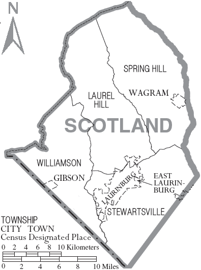
City
- Laurinburg (county seat and largest community)
Towns
- Gibson
- Maxton (partially)
- Wagram
Townships
- Laurel Hill
- Spring Hill
- Stewartsville
- Williamson
Census-designated places
- Deercroft
- Laurel Hill
- Old Hundred
- Scotch Meadows
Unincorporated communities
- East Laurinburg
- Montclair
References
Works cited
References
- Martin, Jonathan. "Scotland County (1899)". John Locke Foundation.
- Martin, Jonathan. "Richmond County (1779)". John Locke Foundation.
- (June 29, 1916). "Scotland County 1906---1916". The Laurinburg Exchange.
- John, Maxcy L.. (June 29, 1916). "Historical Sketch of Laurinburg". The Laurinburg Exchange.
- McKnight, Bonnie. (March 22, 2005). "100 County Countdown: Scotland County". The Herald-Sun.
- Linville, Ray. (2019). "Laurinburg-Maxton Army Air Base". North Carolina Government & Heritage Library.
- Myers, Betty P.. "History". City of Laurinburg, NC.
- Ranii, David. (August 2, 2015). "Recruiting industry is Scotland's goal". The News & Observer.
- Heffernan, Sloane. (September 21, 2018). "Fatal flood waters wash away chunks of downtown Laurinburg". Capitol Broadcasting Company.
- Mazzocchi, Jay. (2006). "Scotland County". North Carolina Government & Heritage Library.
- (August 23, 2022). "2020 County Gazetteer Files – North Carolina". United States Census Bureau.
- Elder, Renee. (August 13, 2021). "Black residents in a small NC town say their community is neglected. What happens now?". Border Belt Independent.
- "Relocating to Scotland County". Laurinburg-Scotland County Area Chamber of Commerce.
- "Along the Lumbee River: An Introduction". [[Architectural League of New York]].
- (2020). "Chapter 3 Little Pee Dee Subbasin". North Carolina Department of Environmental Quality.
- "Lumber River, North Carolina". U.S. Fish and Wildlife Service.
- (July 23, 2019). "Sandhills Game Land". Richmond Country Tourism Development Authority.
- "Lumber River State Park". NC Division of Parks & Recreation.
- (2021). "2020 Decennial Census Demographic Profile (DP1)".
- (2023). "2020 Decennial Census Demographic and Housing Characteristics (DHC)".
- (2021). "2020 Decennial Census Redistricting Data (Public Law 94-171)".
- Cline, Michael. (November 10, 2021). "Native American Population Sees Notable Increase in 2020 Census". University of North Carolina at Chapel Hill.
- "P004: Hispanic or Latino, and Not Hispanic or Latino by Race – 2000: DEC Summary File 1 – Scotland County, North Carolina". [[United States Census Bureau]].
- "P2 Hispanic or Latino, and Not Hispanic or Latino by Race – 2010: DEC Redistricting Data (PL 94-171) - Scotland County, North Carolina".
- "P2 Hispanic or Latino, and Not Hispanic or Latino by Race – 2020: DEC Redistricting Data (PL 94-171) - Scotland County, North Carolina".
- (July 21, 2023). "OMB Bulletin No. 23-01: Revised Delineations of Metropolitan Statistical Areas, Micropolitan Statistical Areas, and Combined Statistical Areas, and Guidance on Uses of the Delineations of These Areas".
- "County Population Totals and Components of Change: 2020-2024". United States Census Bureau.
- "U.S. Decennial Census". United States Census Bureau.
- "Historical Census Browser". University of Virginia Library.
- (March 27, 1995). "Population of Counties by Decennial Census: 1900 to 1990". United States Census Bureau.
- (April 2, 2001). "Census 2000 PHC-T-4. Ranking Tables for Counties: 1990 and 2000". United States Census Bureau.
- "State & County QuickFacts". United States Census Bureau.
- "QuickFacts: Scotland County, North Carolina". United States Census Bureau.
- Goldsmith, Thomas. (December 26, 2011). "Scotland County tops jobless chart". The Charlotte Observer.
- Vincent, W. Curt. (August 20, 2021). "Scotland, Laurinburg census numbers drop". The Laurinburg Exchange.
- Nagem, Sarah. (August 20, 2021). "Broadband, entrepreneurs, faith: What would it take for rural NC to regain population?". Border Belt Independent.
- Rappaport, Ben. (June 12, 2024). "Robeson and Scotland counties are growing, slowly, for the first time in years". Border Belt Independent.
- Nagem, Sarah. (July 7, 2022). "Scotland County lowers property tax rate, but it's still the highest in North Carolina". Border Belt Independent.
- Barkin, Dan. (June 6, 2022). "Fort Bragg scoops solar power at a Scotland County lake". Business North Carolina.
- (January 28, 2020). "Richardson explains role of LRCOG to Rotary Club". [[The Laurinburg Exchange]].
- Nagem, Sarah. (April 20, 2022). "Here are races to watch as Scotland County voters go to the polls for May 17 primary". Border Belt Independent.
- Nagem, Sarah. (October 17, 2022). "Here's who is on the ballot in Scotland County for Nov. 8 election". Border Belt Independent.
- (January 13, 2021). "Lumbee Tribal Council swear in new Scotland rep". The Laurinburg Exchange.
- "Scotland County". North Carolina Judicial Branch.
- "About SCSO". Scotland County Sheriff's Office.
- Leip, David. "Dave Leip's Atlas of U.S. Presidential Elections".
- (February 20, 2024). "Rural Black voters, including those in Scotland County, are key for Democrats in NC". Border Belt Independent.
- (November 4, 2022). "Anatomy of a swing state: What these 6 counties tell us about the upcoming NC election". The Charlotte Observer.
- Rappaport, Ben. (April 25, 2024). "In rural Scotland County, voters say candidates must show up to gain their support". Border Belt Independent.
- Rappaport, Ben. (November 6, 2024). "Rural southeastern NC gets more red, even as Democrats win key state races". Border Belt Independent.
- Nguyen, Britney. (June 15, 2021). "Scotland County, halfway between Charlotte and the NC coast, looks to distribution". Border Belt Independent.
- Sinclair, Tomeka. (August 31, 2023). "Scotland County's 6.7% July unemployment rate tops figures across state". The Laurinburg Exchange.
- Skinner, Victor. (December 1, 2023). "Edgecombe most distressed, Currituck the least in new tier designations".
- Mildenberg, David. (October 18, 2022). "S.C. combat rations company adding 440 jobs in Scotland County". Business North Carolina.
- Nagem, Sarah. (March 24, 2022). "Here's how one North Carolina town is bringing its downtown back to life". Border Belt Independent.
- Rappaport, Ben. (November 8, 2024). "In major shift, Republicans gain majority on Scotland County Board of Commissioners". Border Belt Independent.
- Nagem, Sarah. (May 9, 2022). "The fight for better health (and health care) in rural North Carolina". Border Belt Independent.
- (May 2011). "Interstate 73/74 Economic Atlas of North Carolina".
- South Carolina Department of Transportation. "I-73 Northern Map". South Carolina Department of Transportation.
- (January 10, 2019). "New highway projects for Div. 8 added". The Laurinburg Exchange.
- "Location & Transportation". Scotland County Government.
- Brown, Tonya. (September 20, 2022). "Coroner identifies body found near Scotland County store". Sinclair Broadcast Group.
- (September 18, 2018). "NCDOT Division 8 Crews Clean Up After Florence". North Carolina Department of Transportation.
- "Routes". Scotland County Government.
- "About Us". Scotland County Schools.
- Retana, Judith. (September 1, 2021). "These are NC's lowest-performing school districts". Nexstar Media Inc..
- Rowles, Courtney. (November 18, 2022). "Scotland County woman talks about school fight that left her son badly hurt". Sinclair Broadcast Group.
- "Our History".
- "Scotland County, North Carolina". [[U.S. Census Bureau]].
- Nagem, Sarah. (November 16, 2022). "How safe are the hospitals in North Carolina's Border Belt? New grades released". Border Belt Independent.
- Locklear, Hunter. (July 2, 2021). "Highland Games will return to Scotland County in October". The Laurinburg Exchange.
- "Scotland Highlanders". Scotland County Tourism Development Authority.
- King, Katie. (January 26, 2022). "A Guide to Downtown Laurinburg". Our State.
- "African American". Scotland County Tourism Development Authority.
- "NC Listings in the National Register of Historic Places". North Carolina Department of Natural and Cultural Resources.
- Capps, Tanner. "The Work of Faith: A Report on Rural Church Life in the Time of Pandemic". Architectural League of New York.
- "Cities & Towns". Scotland County Government.
- "Feature Details: Deercroft Census Designated Place". U.S. Geological Survey.
- "Feature Details: Laurel Hill Census Designated Place". U.S. Geological Survey.
- "Feature Details: Old Hundred Census Designated Place". U.S. Geological Survey.
- "Feature Details: Scotch Meadows Census Designated Place". U.S. Geological Survey.
- Marsh, Brayden. (July 5, 2022). "East Laurinburg charter dissolved for financial mismanagement". John Locke Foundation.
- "Feature Details: Montclair". U.S. Geological Survey.
This article was imported from Wikipedia and is available under the Creative Commons Attribution-ShareAlike 4.0 License. Content has been adapted to SurfDoc format. Original contributors can be found on the article history page.
Ask Mako anything about Scotland County, North Carolina — get instant answers, deeper analysis, and related topics.
Research with MakoFree with your Surf account
Create a free account to save articles, ask Mako questions, and organize your research.
Sign up freeThis content may have been generated or modified by AI. CloudSurf Software LLC is not responsible for the accuracy, completeness, or reliability of AI-generated content. Always verify important information from primary sources.
Report