From Surf Wiki (app.surf) — the open knowledge base
Saskatchewan Highway 11
Provincial highway in Saskatchewan, Canada

Provincial highway in Saskatchewan, Canada
| Field | Value | |||||
|---|---|---|---|---|---|---|
| province | SK | |||||
| type | Hwy | |||||
| route | 11 | |||||
| alternate_name | Louis Riel Trail | |||||
| maint | Ministry of Highways and Infrastructure& Transport Canada | |||||
| map | ||||||
| map_custom | yes | |||||
| map_notes | Highway 11 highlighted in red | |||||
| length_km | 393.3 | |||||
| length_round | 1 | |||||
| length_ref | {{google maps | |||||
| title | Highway 11 in Saskatchewan | |||||
| url | https://www.google.ca/maps/@51.7526623,-105.6888776,7.58z | |||||
| access-date | October 3, 2025}} | |||||
| direction_a | South | |||||
| terminus_a | in Regina | |||||
| junction | {{plainlist | |||||
| *{{jct | state | SK | Hwy | 11A}} near Regina | ||
| *{{jct | state | SK | Hwy | 20}} at Lumsden | ||
| *{{jct | state | SK | Hwy | 2}} at Chamberlain | ||
| *{{jct | state | SK | Hwy | 44}} at Davidson | ||
| *{{jct | state | SK | Hwy | 15}} at Kenaston | ||
| *{{jct | state | SK | YH | 16}} in Saskatoon | ||
| *{{jct | state | SK | Hwy | 7 | Hwy | 14}} in Saskatoon |
| *{{jct | state | SK | Hwy | 5}} in Saskatoon | ||
| *{{jct | state | SK | Hwy | 12}} in Saskatoon}} | ||
| direction_b | North | |||||
| terminus_b | south of Prince Albert | |||||
| rural_municipalities | Sherwood No. 158, Lumsden No. 189, Dufferin No. 190, Sarnia No. 221, Craik No. 222, Arm River No. 252, Willner No. 253, McCraney No. 282, Rosedale No. 283, Dundurn No. 314, Corman Park No. 344, Rosthern No. 403, Duck Lake No. 463, Prince Albert No. 461 | |||||
| cities | Regina, Saskatoon, Prince Albert | |||||
| previous_type | Hwy | |||||
| previous_route | 10 | |||||
| next_type | Hwy | |||||
| next_route | 12 |
| access-date = October 3, 2025}}
- near Regina
- at Lumsden
- at Chamberlain
- at Davidson
- at Kenaston
- in Saskatoon
- in Saskatoon
- in Saskatoon
- in Saskatoon}}
Highway 11 is a major north–south highway in Saskatchewan, Canada, that connects the province's three largest cities: Regina, Saskatoon, and Prince Albert. It is a structural pavement major arterial highway which is approximately 393 km long.{{Citation |url-status=dead |archive-url=https://web.archive.org/web/20090224215443/http://www.highways.gov.sk.ca/adx/aspx/adxGetMedia.aspx?DocID=227%2C81%2C1%2CDocuments&MediaID=1461&Filename=surface.pdf |archive-date=February 24, 2009
From Regina to Saskatoon, Highway 11 is a four-lane divided highway except in the village of Chamberlain, where the road narrows to two lanes through the community, including its intersection with Highway 2 south to Moose Jaw. Highway 11 passes through Saskatoon, officially following Idylwyld Drive through the downtown area; however, Circle Drive is also signed as Highway 11 which serves as bypass route. North of Saskatoon, the road continues as a four-lane divided highway{{Citation |access-date = May 20, 2012 |archive-url = https://web.archive.org/web/20140118164334/http://www.thestarphoenix.com/news/Highway+fully+twinned+from+Saskatoon+Prince+Albert/9083113/story.html |archive-date = January 18, 2014 |url-status = dead |archive-url=https://web.archive.org/web/20090224215438/http://www.highways.gov.sk.ca/adx/aspx/adxGetMedia.aspx?DocID=227%2C81%2C1%2CDocuments&MediaID=1501&Filename=2007-08%2BNHS.pdf |url-status=dead |archive-date=February 24, 2009 |access-date=February 8, 2009
Most of the intersections along the highway are at-grade; however, there are several interchanges and overpasses along the Regina Bypass and through Saskatoon. There is a partial cloverleaf at Lumsden in the Qu'Appelle Valley and another one at Warman.
History
Beginnings
The Qu'Appelle, Long Lake and Saskatchewan Railway came through the region between Regina and Prince Albert via Saskatoon, as early as 1890 providing an early method of travel following the Red River cart and trail days.{{cite encyclopedia | access-date=December 30, 2007}} Chamberlain and Aylesbury were first linked via a highway in 1929; before this date transportation between the two was by a variety of trails. The summer of 1929 also started another road leaving the Qu'Appelle River valley east. Construction required building up low spots with elevating graders and dump wagons operated by horses. The elevating grader was to till unbroken soil and turn it towards a conveyor which lifted the dirt into the dump wagons. This process used eight horses pulling in the front, and another eight at the rear pushing. The fresno crew constructed the level areas. Ditches were constructed on a 7% grade and filled with field rock to help prevent erosion. One of the main problems constructing the highway was the heavy field stone knolls. This highway served until 1949 when it was upgraded.{{Citation
|access-date=December 29, 2007 |url-status=dead |archive-url=https://web.archive.org/web/20071120061044/http://www.roadsideattractions.ca/wirebuffalo.htm |archive-date=November 20, 2007 |access-date=December 29, 2007 |url-status=dead |archive-url=https://web.archive.org/web/20090224215454/http://www.craik.ca/trta/05winternews.pdf |archive-date=February 24, 2009 }}}}
The 1926 highway map of Saskatchewan marks the route of Provincial Highway 11 following along the Canadian National Railway (CNR) using township and range roads, so travel is in lines straight north, changing direction to west travel at 90 degree angles from Regina through to Saskatoon. Only Provincial Highway 12 is marked in the same fashion between Saskatoon and Prince Albert on the 1926 highway map of Saskatchewan, which has formed the base of the northern section of Highway 11.{{cite web | access-date=December 30, 2007}} (The current Saskatchewan Highway 12 travels between Saskatoon and Shell Lake.)
As tractors replaced horses in the field and motorized vehicles replaced horses on the road, an increasing need arose to replace the early dirt trails with graded gravel highways. In the early 1930s, the gravel highway constructed between Chamberlain and Aylesbury in 1929 was further extended to Dundurn to meet this need. Shortly thereafter, the gravelled highway extended between Saskatoon and Regina.{{Citation
Later history
As the Annual Average Daily Traffic (AADT) increased, the need for wider, all-weather, paved roads became increasingly apparent. As early as the 1930s, various Saskatchewan cities, towns, and rural municipalities lobbied the provincial government to develop hard surfaced roads, including Highway 11, to connect its major centres, particularly Regina, Saskatoon, Prince Albert, and Moose Jaw. Saskatoon mayor R.M. Pinder argued that Highway 11 should receive priority because "it serves the greatest number of people for the longest period of time" and its hard surfacing would facilitate the travel of American tourists to Prince Albert National Park and support transport operations to and from the Dundurn Military Camp. Prince Albert advocated prioritizing Highway 2 as a more direct route between the northern and southern parts of the province and a more attractive route for American tourists driving to Prince Albert National Park. Saskatoon preferred Highway 11 because the alternative would bypass it and not provide as many Saskatchewan residents the transportation benefits of direct access to a paved highway. In 1950, the provincial government indicated that it would prioritize the paving of Highway 11 between Saskatoon and Regina; by October 1952 this section was completely paved.{{cite web | access-date=December 30, 2007}}
The improved highway was also re-routed in some places, including the section between Bladworth and Dundurn which was completely rebuilt and bypassed. The highway between Saskatoon and Prince Albert received less attention during this period; a 1956 highway map shows that it was still almost entirely gravel.
Following the completion of the Trans-Canada Highway through Saskatchewan, federal funds became available for provincial highway projects. Highway 11 was considered an important transportation route from a national perspective, and therefore received funding under the National Highways Project.{{cite encyclopedia
In 1960, the section between Regina and Lumsden was the first to be converted to a four lane twinned highway. Twinning the rest of highway between Saskatoon and Regina commenced in 1968 with the conversion of the segment between Saskatoon and Dundurn. With the exception of a three-kilometre, two-lane segment through Chamberlain, Sections of highway nearest to Saskatoon were twinned first; with the paving of newly constructed lanes along a 13 km stretch between Prince Albert and MacDowall, the project was completed on October 25, 2013.
In 1971, the Department of Highways was moved from Hawarden to Kenaston, which was closer to Highway 11.{{Citation
On June 20, 2001, the entire length of Highway 11 was re-named the 'Louis Riel Trail' (LRT) at a ceremony which took place at the Duck Lake Regional Interpretive Centre. The LRT connects major sites of the 1885 North-West Rebellion. Mid-Lakes Community coalition, Highway 11 communities and municipalities, the Saskatchewan Métis Nation, and the Saskatchewan History and Folk Lore Society approached Highways and Transportation Minister Pat Atkinson about the designation. Saskatchewan Highway 11 is the actual course followed by the RCMP and Louis Riel to arrive at Regina for the trial of Louis Riel.{{cite web | access-date=December 30, 2007}} The LRT sign features a red river cart featured in yellow on a blue background.{{cite web |access-date=December 30, 2007 |url-status=dead |archive-url=https://web.archive.org/web/20101210033719/http://www.gov.sk.ca/news?newsId=141269c2-bc32-4366-90c9-30e3c30dbfe0 |archive-date=December 10, 2010 }}
In 2008, Pinkie Road was a proposed as a four-lane twinned highway connector road linking two National Highway System routes as a part of the Asia-Pacific Gateway and Corridor Initiative (APGCI), linking Highway 1, the Trans-Canada Highway, and Highway 11. This route was expended to continue east and bypass southern and eastern Regina, connecting with Highway 1 east of the city. The Regina Bypass was opened in October 2019 with Highway 11 being designated to the western leg of the route, while a 7.3 km bypassed section of Highway 11 became Highway 11A.
Maintenance
Tenders for construction work on Highway 11 in 2008 amounted to $63.3 million of which $30 million saw 35 km twinned between Prince Albert and Saskatoon. Among the projects that had received approval were the "paving of two sections of Highway 11 including 12.1 km of highway north of Osler to south of Hague, and 11.3 km of highway north of Macdowall to the Junction of Highway 2".{{cite web | access-date =December 30, 2007 | archive-date =December 5, 2021 | archive-url =https://web.archive.org/web/20211205030026/http://www.highways.gov.sk.ca/ | url-status =dead
In 2002 a resurfacing project of 8.4 km of Highway 11 was undertaken on a section 2.3 km north of MacDowall. The approval for the $680,000 tender was awarded by Highways and Transportation Minister Mark Wartman.{{cite web |access-date=December 30, 2007 |url-status=dead |archive-url=https://web.archive.org/web/20101210033513/http://www.gov.sk.ca/news?newsId=6de7601f-a4aa-4aaf-a262-84a6e1913922 |archive-date=December 10, 2010
Earlier maintenance included $897,000 for paving of 12.3 km near Hanley for a project cost of $897,000. Highways and Transportation Minister Judy Bradley awarded contracts for work in 1999.{{cite web
The first asphalt rubber project occurred in July 2007 on Saskatchewan Highway 11. Close to 8 km near Davidson show the rubberized asphalt road surface on the right lane at a cost of $126,800. The next rubberized asphalt project in the summer of 2007, was 4 km through Chamberlain. The $1.4 million spent there included the rubberized asphalt pavement surface, curbs, and catch basins.{{cite web | access-date=January 18, 2008}}
Route description
Highway 11 is a major, primary weight{{cite web|url=http://www.highways.gov.sk.ca/adx/aspx/adxGetMedia.aspx?DocID=227,81,1,Documents&MediaID=1502&Filename=2007-08+weight+map.pdf |url-status=dead |archive-url=https://web.archive.org/web/20090224215435/http://www.highways.gov.sk.ca/adx/aspx/adxGetMedia.aspx?DocID=227%2C81%2C1%2CDocuments&MediaID=1502&Filename=2007-08%2Bweight%2Bmap.pdf |archive-date=February 24, 2009 |archive-url=https://web.archive.org/web/20090224215455/http://www.highways.gov.sk.ca/adx/aspx/adxGetMedia.aspx?DocID=227%2C81%2C1%2CDocuments&MediaID=1386&Filename=trafficvolume-2007.pdf |url-status=dead |archive-date=February 24, 2009 |access-date=February 8, 2009 |access-date=December 30, 2007 |url-status=dead |archive-url=https://web.archive.org/web/20050824200020/http://www.sasktourism.com/default.asp?Page=175&menu=52 |archive-date=August 24, 2005 }} The only section not divided is a short segment through the village of Chamberlain. The highway is also known as the Louis Riel Trail. It was co-named as such in 2001 after the Métis leader Louis Riel, who was tried and hanged in Regina on September 18, 1885 for treason.{{cite web | access-date=December 30, 2007 | archive-url =https://web.archive.org/web/20071207193314/http://www.mysteriesofcanada.com/Canada/riel.htm | archive-date =2007-12-07}}
Don Wilkins, a retired farmer from Davidson, created eight metal sculptures that portray the legacy of the province's Métis people. They are at various points along Highway 11 between Regina and Prince Albert.
Trans-Canada Highway to Davidson

Highway 11's southern terminus begins just south-west of Regina in the Rural Municipality of Sherwood No. 159 where the Regina Bypass meets Highway 1, the Trans-Canada Highway. It then travels north along Regina's western boundary, crosses Wascana Creek, and briefly passes through Regina's city limits. Access to the Global Transportation Hub is from the Dewdney Avenue (Hwy 730) and Rotary Avenue exits. Prior to the completion of the Regina Bypass in October 2019, Highway 11 began at the junction of Victoria Avenue and Ring Road in the east end of the city, and shared an 8.2 km long concurrency with Highway 6, before branching north-west from Albert Street at Regina's northern boundary, passing Pasqua Street. As part of the Regina Bypass, the Highway 11 designation was moved to the new freeway, while the bypassed section of Highway 11 between Highway 6 (Albert Street) and the Regina Bypass was redesignated as Highway 11A.

From the junction with Highway 11A, Highway 11 heads north-west where it passes a weigh station, crosses Boggy Creek, runs alongside Condie Nature Refuge, intersects Highway 734, and enters the Rural Municipality of Lumsden No. 189. Highway 11 continues north towards the Qu'Appelle Valley. As it approaches the valley, it gradually turns west and then descends into it. On the valley floor, the highway crosses the Qu'Appelle River and intersects Highway 20 in a partial cloverleaf interchange. West from the interchange is Highway 641 and the town of Lumsden, while north-east along Highway 20 is the village of Craven. From that interchange, Highway 11 climbs out of the valley and intersects Highway 54. Highway 54 heads north and provides access to Last Mountain Lake. Highway 11 continues west for a further 11 km, at which point, it turns north-west en route to the village of Bethune. At Bethune, three highways intersect Highway 11 — 354, 642, and 739. Continuing north-west, the highway passes the former Bethune Recreation Site and heads to Findlater. About 2 km past Findlater, it begins an 11.6 km long concurrency with the north–south Highway 2 (Veterans Memorial Highway) that ends in the village of Chamberlain. Southbound on 2 is Moose Jaw while northbound is Watrous and Little Manitou Lake.{{cite web |access-date=December 30, 2007 |archive-url=https://web.archive.org/web/20071218090035/http://www.becquet.com/director/maps/Moose_Jaw.htm |archive-date=December 18, 2007 |url-status=dead |access-date=December 29, 2007 |url-status=dead |archive-url=https://web.archive.org/web/20090224215440/http://www.craik.ca/trta/04springnews.pdf |archive-date=February 24, 2009 |access-date=December 29, 2007 |url-status=dead |archive-url=https://web.archive.org/web/20090224215441/http://www.craik.ca/trta/04summernews.pdf |archive-date=February 24, 2009
Regina to Davidson roadside attractions
Roadside attractions from Regina to Davidson include:
- Condie Nature Refuge in the RM of Sherwood No. 159
- "The Surveyor" — a Don Wilkins sculpture in Chamberlain
- "Buffalo" — a Don Wilkins sculpture and roadside pullout between Chamberlain and Aylesbury
- "New Trails Await" The Oxen — a Don Wilkins sculpture in Aylesbury
- Craik and District Regional Park in the RM of Craik No. 222
- Red River Cart and roadside pullout north of Girvin in the RM of Arm River No. 252
Davidson to Saskatoon
From Davidson, Highway 11 continues to Saskatoon. About 15 km north-west of Davidson along the highway is the village of Bladworth. Kenaston, and the intersection with Highway 15, is a further 19.5 km up the highway. Highway 15 is an important east–west highway that runs from Highway 16 (the Yellowhead Highway) near the Manitoba border west to Highway 4 south of Rosetown. Travelling north-west from Kenaston, Highway 11 intersects Highway 764, provides access to Hanley, and drops into the Blackstrap Coulee. In the valley, the highway passes between the southern end of Blackstrap Lake and the northern end of Indi Lake. As it climbs out of the valley, the highway straightens out and takes more of a northerly route to Saskatoon. Here, it intersects Highways 663 and 211. Highway 211 goes west into Dundurn and east into Blackstrap Provincial Park. CFD Dundurn is located north-west of Dundurn along Brightwater Creek. A further 18 km north of Dundurn, Highway 11 enters the city of Saskatoon.
Davidson to Saskatoon roadside attractions
Roadside attractions from Davison to Saskatoon include:
- "The Fiddler" — a Don Wilkin's Art Installation in Davidson
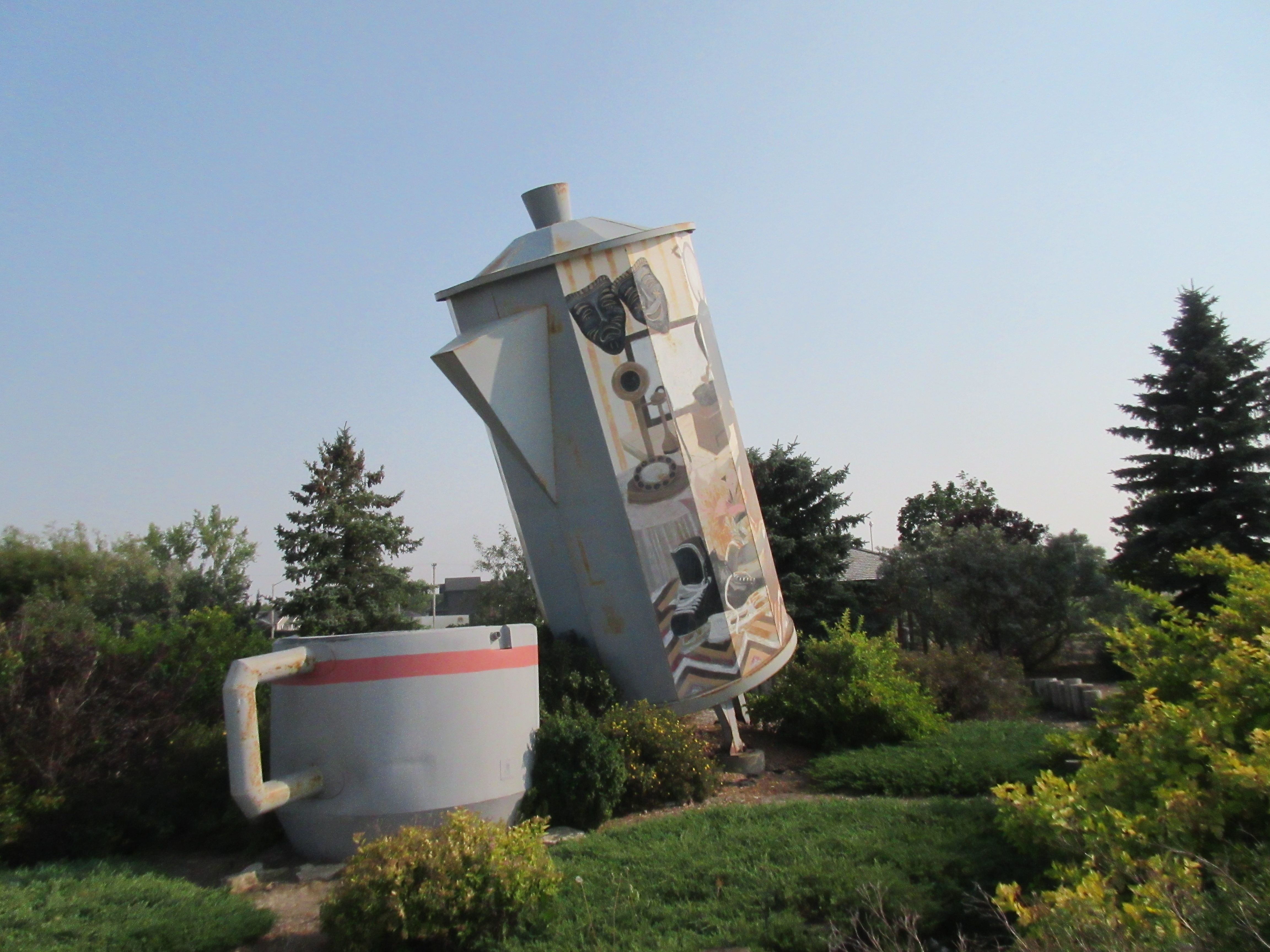
- Big Coffee Pot and Cup at a roadside pullout in Davidson
- Louis Riel Trail Stop — a roadside pullout on the east side of the highway from Bladworth
- Kenaston Snowman in Kenaston
- Bonnington Springs Campground in Kenaston
- "The Lesson" — a Don Wilkins Art Installation in the RM of Rosedale No. 283
- "Red River Cart" — a sculpture by Don Wilkins in Hanley
- "The Bone Gatherer" — a Don Wilkins art installation in Dundurn
- Saskatchewan International Raceway — 8 miles south of Saskatoon
Saskatoon
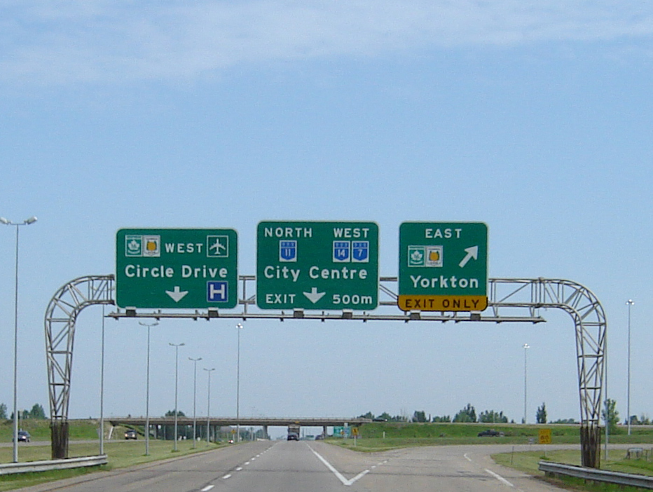
Highway 11 enters Saskatoon with the neighbourhood of Stonebridge on the west and the South East Development Area on the east. It then enters into a cloverleaf interchange with Highway 16 (the Yellowhead Highway) with Highway 16 continuing north and Highway 11 exiting west as part of Circle Drive. This cloverleaf interchange, which opened in 1967, was one of the first two interchanges in Saskatchewan. Circle Drive and Highway 11 run concurrently west for 4 km at which point Highway 11 turns north as Idylwyld Drive Freeway while Circle Drive continues west over the South Saskatchewan River via the Gordie Howe Bridge. Highway 11, travelling north, crosses the South Saskatchewan River via the Senator Sid Buckwold Bridge and enters downtown Saskatoon. It runs along the western boundary of downtown as an arterial roadway concurrently with Idylwyld Drive. The highway intersects Highways 7 and 14 at 22nd Street and Highway 5 at 25th Street. It rejoins Circle Drive and Highway 16 2.7 km north of downtown at a diamond interchange. Highway 11 and 16 then share a 2.8 km northbound concurrency as a short freeway. Highway 16 branches to the north-west, and 2.6 km farther north, Highway 11 branches north-east at an intersection with Highway 12 and leaves Saskatoon en route to Highway 2 and Prince Albert.
Numerous attractions in Saskatoon, the largest city of Saskatchewan, include the Forestry Farm Park and Zoo, Remai Modern Art Gallery, and the Wanuskewin Heritage Park.
Saskatoon to Highway 2
This segment of Highway 11 travels north-northeast roughly paralleling the South Saskatchewan River to its northern terminus at Highway 2, about 6.5 km south of downtown Prince Albert. From the intersection with Highway 12, Highway 11 heads north-east then north-northeast to the city of Warman. At Warman, it intersects with Highway 784 at central part of the city and Highway 305 (via a partial cloverleaf) at the north end. From 305, it turns north and travels through Osler. About a mile north of Osler, the highway resumes its north-northeasterly travel and provides access to the communities of Reinland, Neuanlage, Hochstadt, and Hague. At Hague, it intersects with Highway 785. Highway 11 travels a further 17.3 km from the intersection with 785 to the town of Rosthern and Highway 312. Valley Regional Park, situated on the western shore of Rempel Lake, is about a mile further along 11 on the eastern side of the highway. Continuing from the regional park, Highway 11 heads past Duck Lake to the town of Duck Lake and the intersection with Highways 212 and 783. Duck Lake is near the location of the Battle of Duck Lake that occurred in 1885. There is the commemorative Duck Lake Monument west along Highway 212. The final leg of this stretch of highway from Duck Lake to its northern terminus travels in a north-easterly direction. It travels through the Nisbet Provincial Forest with several access points along the highway. Coming out of the forest, Highway 11 pulls away from the South Saskatchewan River as the river turns east while the highway continues north-east. It passes through MacDowall and Clouston before reaching its northern terminus at Highway 2 (Veterans Memorial Highway) south of Prince Albert. The North Saskatchewan River is only 7.1 km north of Highway 11's northern terminus.
Saskatoon to Prince Albert roadside attractions
Roadside attractions from Saskatoon to the highway's northern terminus at Highway 2 south of Prince Albert include:
- Sutherland Automotive Speedway — just north of Saskatoon
- Valley Regional Park — north of Rosthern
- Duck Lake Regional Interpretive Centre — at Duck Lake
- Our Lady Of Lourdes Mini Shrine — north-west of Duck Lake at the southern edge of the Nisbet Provincial Forest
- Access to Nisbet Forest trails
- Eb's Nordic Ski Trails in the Nisbet Forest
- Valleys of the Saskatchewan Map at the northern edge of the Nisbet Forest
- Vintage Power Machines Museum — museum north-west of Clouston
Major intersections
From south to north:
Highway 11A
Highway 11A is a short freeway serving the city of Regina. It runs from the intersection with Highway 6 at Regina's northern city limit to Highway 11, about 7 km north-west of Regina. It is the original configuration for Highway 11 as it approached Regina and was designated after the Regina Bypass was opened in October 2019.
Highway 11 used to be signed through Regina along Albert Street and Ring Road to Victoria Avenue where it terminated at the Trans-Canada Highway (Highway 1); however, the Highway 11A designation only pertains to the area outside city limits where it is under provincial jurisdiction. Highway 11A is largely unsigned, with signage reflecting Highway 11.
Major junctions
From south to north.
References
References
- Government of Saskatchewan. (June 12, 2025). "Highway Official Road Network". [[Esri]].
- "Highway Network". University of Regina.
- (18 June 1930). "Much Work Being Done On Highways". Saskatoon Star-Phoenix.
- (16 June 1938). "Big Advantages in Main Highway Through Davidson". Saskatoon Star-Phoenix.
- (20 May 1938). "No. 11 Sought As Main Road". The Leader-Post.
- (6 May 1950). "Choice of paved north-south route matter of conjecture". The Leader-Post.
- (24 August 1949). "Headache for Mr. Douglas". The Leader-Post.
- (23 August 1949). "Population Density Much Greater on No. 11-12 Highway". Saskatoon Star-Phoenix.
- (3 May 1950). "The Highway Program". Saskatoon Star-Phoenix.
- (11 October 1952). "At Last, Dream Comes True! Regina-Saskatoon Highway Now All Paved; Distance Cut to 168 Miles". Saskatoon Star-Phoenix.
- (1956). "Shell Map of British Columbia, Alberta, Saskatchewan and Manitoba". Shell Oil Company.
- (13 June 1964). "Highway Decisions Due 'Soon'". Saskatoon Star-Phoenix.
- (18 June 1964). "Plan Highway Work Costing $900,000". Saskatoon Star-Phoenix.
- (16 August 1966). "Worst highway sections to have first attention". The Leader-Post.
- (29 August 1967). "Work to begin on new highway". Saskatoon Star-Phoenix.
- (3 August 1966). "Highway 11 to Regina to miss all but Davidson". Saskatoon Star-Phoenix.
- (2 November 1978). "Westward 4-laning planned". Saskatoon Star-Phoenix.
- (20 October 1977). "Highway 11 section opens". Saskatoon Star-Phoenix.
- Di Pietro, Alex. (27 August 2012). "Province unsure of when paving project will be completed". The Prince Albert Daily Herald.
- "Highway 11 Twinning". Government of Saskatchewan: Highways and Infrasrructure.
- (31 July 2015). "Sculptures along Highway 11 pay tribute to Sask. Métis culture". Rawlco Radio.
- (October 10, 2019). "Highway Name Changes At The Regina Bypass".
- "Weigh Scale Locations". Government of Saskatchewan.
- "Regina - Condie Nature Refuge". Government of Saskatchewan.
- "South - Lumsden - Hwys 11, 20". Government of Saskatchewan.
- "About Us". Village of Bethune.
- "South - Findlater - Hwy 11". Government of Saskatchewan.
- "South - Chamberlain - Hwys 2, 11". Government of Saskatchewan.
- (17 July 2013). "Last Leg of Highway 11 Twinning Underway Near MacDowall". Government of Saskatchewan.
- (8 January 2016). "Here or over there: South Saskatchewan towns ponder where highways should go". Postmedia Network.
- "Welcome to the Town of Davidson". Town of Davidson.
- "Central - Davidson - Hwys 11, 44". Government of Saskatchewan.
- "Regina - Condie Nature Refuge". Government of Saskatchewan.
- "Craik & District". Saskatchewan Regional Parks.
- "Village Of Kenaston Heritage, Spirit, Vision". Village of Kenaston.
- "Central - Hanley - Hwy 11". Government of Saskatchewan.
- "Blackstrap Coulee". Government of Canada.
- "Town of Dundurn". Town of Dundurn.
- "Saskatoon - Hwys 5, 7, 11, 12, 14, 16, 219". Government of Saskatchewan.
- "Kenaston Snowman and Park". Village of Kenaston.
- "Campground". Village of Kenaston.
- "SIR". Saskatchewan Drag Racing Association.
- "Saskatchewan Highway #11: Saskatoon to Regina". TransCanada FoundLocally.
- "Saskatoon Forestry Farm Park & Zoo". Discover Saskatoon.
- "Welcome to Remai Modern".
- "Wanuskewin Heritage Park". Government of Saskatchewan.
- "Central - Warman - Hwys 11, 305". Government of Saskatchewan.
- "Central - Osler - Hwy 11". Government of Saskatchewan.
- "Central - Hague - Hwy 11". Government of Saskatchewan.
- "Nisbet Provincial Forest - map and other informations". TravelerMap.
- "Nisbet Provincial Forest". Mindtrip.
- "Sutherland Automotive Speedway". Sutherland Automotive Speedway.
- "Valley". Saskatchewan Regional Parks.
- "Vintage Power Machines Inc". Government of Saskatchewan.
- "Highway 11A in Saskatchewan".
This article was imported from Wikipedia and is available under the Creative Commons Attribution-ShareAlike 4.0 License. Content has been adapted to SurfDoc format. Original contributors can be found on the article history page.
Ask Mako anything about Saskatchewan Highway 11 — get instant answers, deeper analysis, and related topics.
Research with MakoFree with your Surf account
Create a free account to save articles, ask Mako questions, and organize your research.
Sign up freeThis content may have been generated or modified by AI. CloudSurf Software LLC is not responsible for the accuracy, completeness, or reliability of AI-generated content. Always verify important information from primary sources.
Report