From Surf Wiki (app.surf) — the open knowledge base
Sangre de Cristo Range
American mountain range

American mountain range
| Field | Value |
|---|---|
| name | Sangre de Cristo Range |
| other_name | Northern Sangre de Cristo Mountains |
| photo | Sangredecristomtns.JPG |
| photo_size | 350px |
| photo_caption | Sangre de Cristo Range seen from Hardscrabble Pass. |
| etymology | Sangre de Cristo |
| country | United States |
| subdivision1 | Colorado |
| subdivision2_type | Counties |
| subdivision2 | |
| parent | Sangre de Cristo Mountains, Rocky Mountains |
| borders_on | |
| age | |
| orogeny | Fault-block mountains |
| area_mi2 | 1250 |
| length_mi | 75 |
| length_orientation | north-south |
| width_mi | 48 |
| width_orientation | east-west |
| highest | Blanca Peak |
| elevation_ft | 14345 |
| coordinates | |
| map | USA Colorado |
| label | Sangre de Cristo Range |
the northernmost extent of the greater Sangre de Cristo mountain range
The Sangre de Cristo Range is a mountain range in the Rocky Mountains in southern Colorado in the United States, running north and south along the east side of the Rio Grande Rift. The mountains extend southeast from Poncha Pass for about 75 mi through south-central Colorado to La Veta Pass, approximately 20 mi west of Walsenburg, and form a high ridge separating the San Luis Valley on the west from the watershed of the Arkansas River on the east. The Sangre de Cristo Range rises over 7000 ft above the valleys and plains to the west and northeast.
According to the USGS, the range is the northern part of the larger Sangre de Cristo Mountains, which extend through northern New Mexico. Usage of the terms "Sangre de Cristo Range" and "Sangre de Cristo Mountains" is varied; however, this article discusses only the mountains between Poncha Pass and La Veta Pass.
Notable peaks
A 14er is a mountain peak that has an elevation of at least 14,000 feet. Colorado has 53, the most of any state. There are 10 14ers in the Sangre de Cristo Range, which can be seen in the table below.
| Peak name | Elevation | Prominence | |||
|---|---|---|---|---|---|
| Blanca Peak | 14351 ft | 5326}}5326 ft | |||
| Crestone Peak | 14300 ft | 4534}}4534 ft | |||
| Crestone Needle | 14197 ft | 437}}437 ft | |||
| Kit Carson Peak | {{convert | 14165 | ft | m | abbr=on}} |
| Challenger Point | 14080 ft | 281}}281 ft | |||
| Humboldt Peak | 14064 ft | 1164}}1164 ft | |||
| Culebra Peak | 14047 ft | 4806}}4806 ft | |||
| Ellingwood Point | 14042 ft | 322}}322 ft | |||
| Mount Lindsey | 14042 ft | 1522}}1522 ft | |||
| Little Bear Peak | 14037 ft | 357}}357 ft | |||
| Columbia Point | 13960 ft | 320}}320 ft | |||
| Mount Adams | 13937 ft | 851}}851 ft | |||
| California Peak | 13855 ft | 609}}609 ft | |||
| Rito Alto Peak | 13800 ft | 1114}}1114 ft | |||
| Colony Baldy | 13711 ft | 905}}905 ft | |||
| Pico Aislado | 13612 ft | 837}}837 ft | |||
| Tijeras Peak | 13610 ft | 724}}724 ft | |||
| Electric Peak | 13601 ft | 915}}915 ft | |||
| Cottonwood Peak | 13504 ft | 1108}}1108 ft | |||
| Twin Peaks | 13560 ft | 600}}600 ft | |||
| Broken Hand Peak | 13579 ft | 653}}653 ft | |||
| Fluted Peak | 13560 ft | 714}}714 ft | |||
| Milwaukee Peak | 13528 ft | 282}}282 ft |
Geography
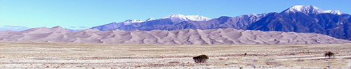
The Sangre de Cristo Mountains run from Poncha Pass in Central Colorado to Glorieta Pass near Santa Fe, New Mexico. Most of the range is shared by two National Forests, which abut along the range divide. Most of the northeast (Arkansas River) side is located within the San Isabel National Forest, while most of the southwest (San Luis Valley) side is included in the Rio Grande National Forest. The central part of the range is designated as the Sangre de Cristo Wilderness. The Great Sand Dunes National Park and Preserve sits on the southwestern flank of the range at the edge of the San Luis Valley. The range divide is traversed by no paved roads, only by four-wheel drive and foot trails over Hayden Pass, Hermit Pass, Music Pass, Medano Pass, and Mosca Pass.

The highest peak in the range, located in the south, is Blanca Peak at 14345 ft; it is flanked by three other fourteeners: Little Bear Peak, Mount Lindsey, and Ellingwood Point.Ellingwood Point is not always counted as an official fourteener, as it has a high saddle connecting it with Blanca Peak, and hence a low topographic prominence. Other well-known peaks are the fourteeners of the Crestone group: Kit Carson Mountain, Crestone Peak, Crestone Needle, and Humboldt Peak. Two sub-peaks of Kit Carson Mountain, Challenger Point and Columbia Point, are named in memory of the crews of the Space Shuttle Challenger and the Space Shuttle Columbia. The range is also home to many high peaks in the 13,000 to 14,000 foot (3,900-4,300 m) range as it continues into New Mexico. In New Mexico most of the mountain area is managed by the US Forest Service in the Carson and Santa Fe National Forests.
Geology
The Colorado Sangre de Cristos are fault-block mountains similar to the Teton Range in Wyoming and the Wasatch Range in Utah. Major fault lines run along the east and west sides of the range, and cut right through the mountains in some places. Like all fault-block mountain ranges, the Sangre de Cristos lack foothills which means the highest peaks rise abruptly from the valleys to the east and west, rising 7000 ft in only a few miles in some places. The mountains were pushed up around 5 million years ago, basically as one large mass of rock. The Sangre de Cristo range is still being uplifted today as faults in the area remain active. Due to uplift (elevation increase) and erosion, rock layers are missing, causing gaps in the range, called "unconformities."
On the west side is the San Luis Valley, a portion of the Rio Grande Rift. On the southeast side is the Raton Basin, a quiet but still active volcanic field. On the northeast side are the Wet Mountains and the Front Range, areas of Precambrian igneous and metamorphic rocks formed during the Colorado orogeny some 1.7 billion years ago and then uplifted more recently during the Laramide orogeny.
The Blanca Massif is also Precambrian rock, while most of the rest of the Sangres is composed of younger Permian-Pennsylvanian (about 250-million-year-old) rock, a mix of sedimentary conglomerates, silty mudstones and shales, sandstones, limestone beds and igneous intrusions. These sedimentary rocks originated as sediment eroded from the Ancestral Rocky Mountains. Crestone Conglomerate are a feature on many of the peaks, including Crestone Needle. The conglomerate settled near the uplift and contains boulders as large as 6 feet in diameter.
Climate
| Year | 23.4 (-4.8) | 58.8 (14.88) | 0.7 (16.02) | 3.3 (7.92) |
|---|
History
Antonio Valverde y Cosio named the Sangre de Cristo range after the red-hue that he saw during the snowy sunrise. Sangre de Cristo means Blood of Christ in English.
In the formation of the range, we can see fossils of footprints, shells and bones.
In August 2009, the Sangre de Cristo Range was dedicated as a National Heritage Area (NHA), an area of cultural, natural, and historic preservation.
Economy
Today, tourism is the main economic activity.
References
;Notes
References
- "The Colorado 14ers {{!}} List of 58 Fourteener Mountains".
- "Blanca Peak".
- "Crestone Peak".
- "Crestone Needle".
- "Kit Carson Mountain".
- "Challenger Point".
- "Humboldt Peak".
- "Culebra Peak - Northwest Ridge {{!}} Route".
- "Ellingwood Point".
- "Mount Lindsey".
- "Little Bear Peak".
- "Columbia Point".
- "Mount Adams".
- "California Peak".
- "Rito Alto Peak".
- "Colony Baldy".
- "Pico Aislado".
- "Tijeras Peak".
- "Electric Peak".
- "Cottonwood Peak".
- "Twin Peaks".
- "Broken Hand Peak".
- "Fluted Peak".
- "Milwaukee Peak".
- (2018-09-16). "The Sangre de Cristo Mountains".
- "USGS Circular 1349: The Geologic Story of Colorado's Sangre de Cristo Range".
- (2017-04-01). "Paleosols of the upper Paleozoic Sangre de Cristo Formation, north-central New Mexico: Record of early Permian palaeoclimate in tropical Pangaea". Journal of Palaeogeography.
- "Sangre de Cristo Mountains : Climbing, Hiking & Mountaineering : SummitPost".
- (2015-03-25). "Alamosa, CO, Colorado, USA: Climate, Global Warming, and Daylight Charts and Data".
- "Sangre de Cristo Mountains {{!}} mountains, United States {{!}} Britannica".
- "Sangre de Cristo National Heritage Area - Great Sand Dunes National Park & Preserve (U.S. National Park Service)".
This article was imported from Wikipedia and is available under the Creative Commons Attribution-ShareAlike 4.0 License. Content has been adapted to SurfDoc format. Original contributors can be found on the article history page.
Ask Mako anything about Sangre de Cristo Range — get instant answers, deeper analysis, and related topics.
Research with MakoFree with your Surf account
Create a free account to save articles, ask Mako questions, and organize your research.
Sign up freeThis content may have been generated or modified by AI. CloudSurf Software LLC is not responsible for the accuracy, completeness, or reliability of AI-generated content. Always verify important information from primary sources.
Report