From Surf Wiki (app.surf) — the open knowledge base
Sanaag
Region of Somaliland

Region of Somaliland
| Field | Value |
|---|---|
| name | Sanag |
| native_name | so |
| ar | |
| settlement_type | Region |
| image_skyline | Almadow Overview.JPG |
| imagesize | 250px |
| image_caption | Overview of the Cal Madow mountains in Sanaag |
| image_map | Sanaag in Somaliland.svg |
| map_caption | Location in Somaliland |
| coordinates | |
| subdivision_type | Country |
| subdivision_name | Somaliland Disputed with Puntland |
| seat_type | Administrative centre |
| seat | Erigavo |
| leader_title | Governor |
| leader_name | Mahamed Elmi Hussein Ahmed |
| area_total_km2 | 54231 |
| population_as_of | 2022 |
| population_note | IPC document listed number |
| population_total | 325136 |
| timezone | EAT |
| utc_offset | +3 |
| blank_name_sec2 | HDI (2021) |
| blank_info_sec2 | 0.448 |
| · 3rd of 18 |
ar · 3rd of 18
Sanag (, ) is an administrative region (gobol) in north eastern Somaliland. Sanaag has a long coastline facing the Gulf of Aden to the north, and is bordered by the region of Sahil to the west, Sool to the south and Somalia to the east. The region is disputed by the self-declared Somaliland and Puntland, a state of Somalia.
Its capital city is Erigavo. Sanaag is the largest region of Somaliland, accounting for 35% of Somaliland's total land area.
The region is partially controlled by Puntland and Somaliland. Puntland claims only the Harti-inhabited parts of region to be part of Somaliland, while the latter claims the entire region - a claim based on the British Somaliland boundaries.
Territorial dispute
Main article: Somaliland-Puntland dispute
The Sanaag region is disputed between Somaliland and Puntland. Somaliland effectively controls the western and central parts of Sanaag. Puntland has effective control over Badhan and other areas in the east. Somaliland has declared its claim to all of Sanaag, but some areas (that it struggles to control) do not actually participate in Somaliland's elections.
History
From 1944 to 1974, modern-day Sanaag region was one of three districts of the Burao region. The other two districts were Burao and Las Anod.{{cite web |access-date=21 February 2007 |archive-date=1 April 2016 |archive-url=https://web.archive.org/web/20160401150117/http://www.lib.utexas.edu/maps/africa/somalia.jpg |url-status=live
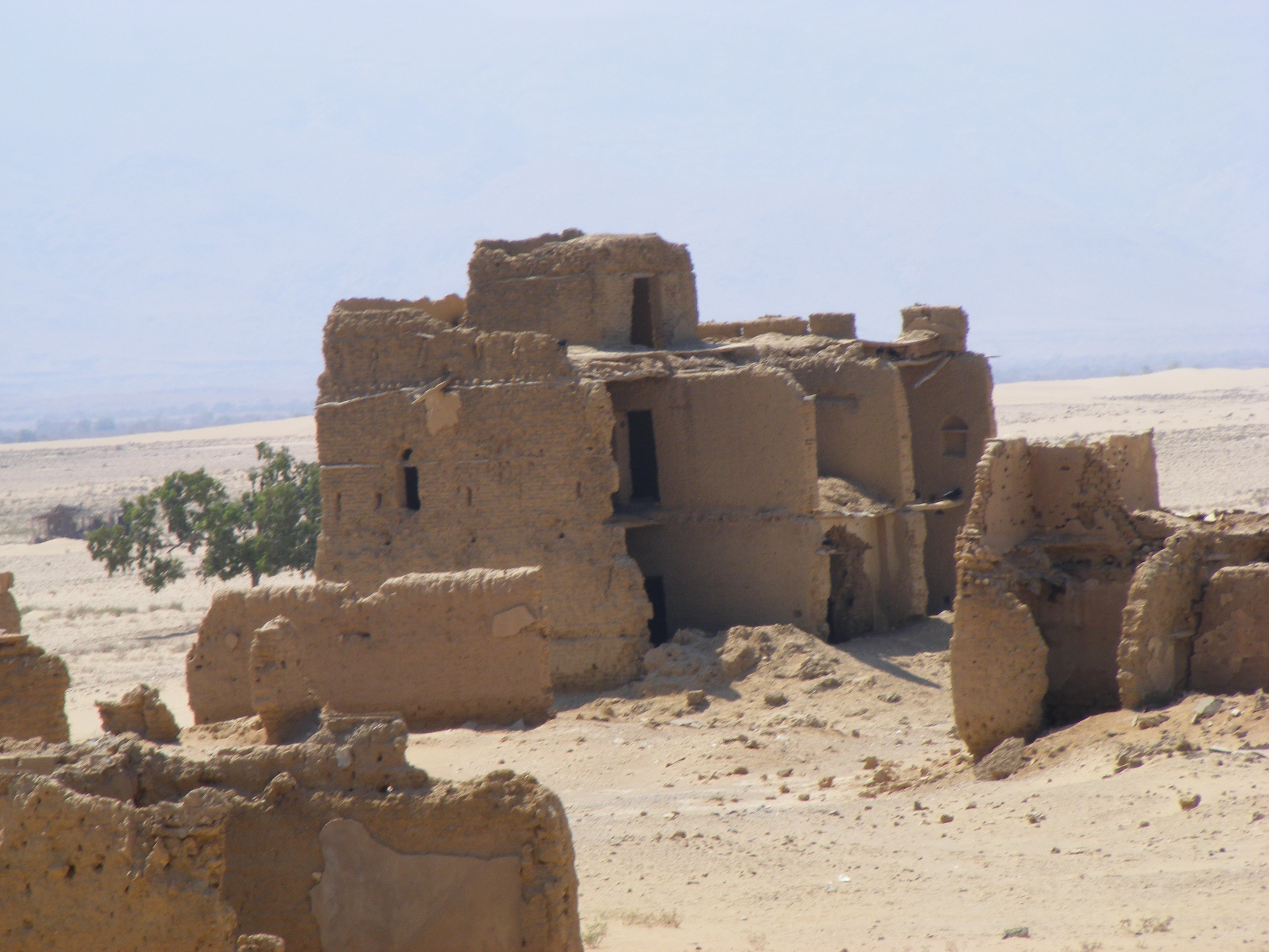
Sanaag is home to numerous archaeological sites, with rock art, ancient ruins, buildings and cairns found at numerous sites, such as Gudmo Biyo Cas, Heis, Maydh, Haylan, Qa'ableh, Qombo'ul, Gelweita and El Ayo. However, many of these old structures have yet to be properly explored, a process which would help shed further light on local history and facilitate their preservation for posterity.
Sanaag is also home to the ruined Islamic city of Maduna near El Afweyn, which is considered the most substantial and most accessible ruin of its type in Somaliland. The main feature of the ruined city includes a large rectangular mosque, its 3 metre high walls still standing and which include a mihrab and possibly several smaller arched niches. Swedish-Somali archaeologist Sada Mire dates the ruined city to the 15th–17th centuries.
Environment
A severe drought in the region in the early part of the 21st century caused an 80% or greater loss of livestock, though two good rainy seasons in 2004–2005 helped restore the area. Over a 15-year period of analysis, from 1988 to 2003, there was a 52% loss of forest and a 40% loss of grassland, and a 370% increase in bare land. Soil erosion due to weather and human activities and clearing of wood and brush for such uses as charcoal and fuel are issues leading to a degradation of the environment.
Economy
In recent history, the Sanaag region normally maintained a diverse economy, producing and then exporting to other regions, it produced livestock, frankincense, and leather for export, this was happening while the region lacked basic infrastructure, but, after the outbreak of civil war the region's economy collapsed from loss of markets and dilapidated infrastructure has never helped, and lack of investment. Now the region only supports one main economy, livestock rearing. The Somali livestock ban imposed by Gulf countries in which was Sanaag's largest market has virtually destroyed the economy in the region, reducing purchasing power and forcing pastoralists in the region to survive on subsistence activities.
The region is connected to Burao, capital of Togdheer region as well as to the rest of the country through the Siilaanyo road.
Demographics
The region is mainly inhabited by people from the Somali ethnic group, principally the Habr Yunis and Habar Jeclo sub-clans of the Isaaq and the Dhulbahante and Warsangali sub-divisions of the Harti Darod.
Districts
The region of Sanag is divided into 5 districts as follows:
- El Afweyn District
- Erigavo District
- Garadag District
- Badhan District
- Dhahar District
Towns and Cities
- Erigavo
- El Afweyne
- Maydh
- Badhan
- Dararweyne
- Las Khorey
- Garadag
- Heis
- Midhisho
- Yubbe
- Hadaaftimo
- Hingalol
- Dhahar
- Buraan
- El Buh
- Gudmo Biyo Cas
- Ruguda
- Yufle
- Dayaha
- Guud Caanood
References
References
- (11 September 2021). "Somaliland: President Bihi Announces Government Reshuffle".
- euaa. (2023). "Somalia: Security Situation".
- "Sub-national HDI - Area Database - Global Data Lab".
- [http://www.statoids.com/uso.html Regions of Somalia] {{webarchive. link. (October 23, 2016)
- "Completed Project".
- (2020-07-06). "Are Somaliland, Puntland ready for war over land?".
- (8 April 2003). "Somalia: No elections in disputed regions, Puntland says - Somalia".
- (2018-06-27). "Averting War in Northern Somalia".
- Mahmood, Omar S.. (2019-11-01). "Overlapping Claims by Somaliland and Puntland: The Case of Sool and Sanaag".
- ISSAfrica.org. (2019-12-09). "The various layers to the Somaliland-Puntland discord".
- (September 2002). "Sanaag region nutrition survey report". [[UNICEF]].
- (2021). "The Puntland Speaker visiting Badhan district". Somali Dispatch.
- (2019). "Overlapping claims by Somaliland and Puntland: The case of Sool and Sanaag". Institute for Security Studies.
- (2019). "Overlapping claims by Somaliland and Puntland: The case of Sool and Sanaag". Institute for Security Studies.
- "Development map, roads, 1944".
- "Faafin rasmi ah ee Jumhuriyadda Dimuqradika Somaliya {{!}} CRL Digital Delivery System".
- Mire, Sada. (2015-04-14). "Mapping the Archaeology of Somaliland: Religion, Art, Script, Time, Urbanism, Trade and Empire". African Archaeological Review.
- Michael Hodd, ''East African Handbook'', (Trade & Travel Publications: 1994), p.640.
- Dev, Bradt Guides. "Maduna ruins".
- Briggs, Philip. (2012). "Somaliland : with Addis Ababa & Eastern Ethiopia". Bradt Travel Guides.
- "Somaliland: archaeology in a breakaway state {{!}} Sada Mire".
- (February 2006). "Environmental Study of Degradation in the Sool Plateau and Gebi Valley: Sanaag Region of Northern Somalia". [[Horn Relief]].
- "Regulating the Livestock Economy of Somaliland".
- Mohamed, Goth. (2020-02-08). "Somaliland: Erigavo-Burao Tarmac Road Gets Long-Awaited Culverts".
- (2013-03-28). "Anatomy of Violence: Understanding the systems of conflict and violence in Africa". Ashgate Publishing Ltd.
- (2021-06-02). "NEC Starts to release Provisional Results of 5 electoral districts".
- "Somaliland President Imposes State-of-Emergency to Sanaag Region".
- "The Somali conflict: Part V: Somaliland: peace-building: 5. Shir Nabadeedka ee Sanaag: 'The Sanaag grand peace and reconciliation conference'".
- "Factors influencing of Somali Women Entrepreneurs in Puntland State: A case study of Baran and Dhahar Districts, Sanaag Region".
This article was imported from Wikipedia and is available under the Creative Commons Attribution-ShareAlike 4.0 License. Content has been adapted to SurfDoc format. Original contributors can be found on the article history page.
Ask Mako anything about Sanaag — get instant answers, deeper analysis, and related topics.
Research with MakoFree with your Surf account
Create a free account to save articles, ask Mako questions, and organize your research.
Sign up freeThis content may have been generated or modified by AI. CloudSurf Software LLC is not responsible for the accuracy, completeness, or reliability of AI-generated content. Always verify important information from primary sources.
Report