From Surf Wiki (app.surf) — the open knowledge base
San Gabriel, California
City in California, United States

City in California, United States
| Field | Value |
|---|---|
| name | San Gabriel, California |
| type | City |
| motto | "City With A Mission" |
| image_skyline | {{Photomontage |
| photo1a | I Like a Place with Benches (6315511083) (cropped).jpg |
| photo2a | San Gabriel Mission 2010 (cropped).jpg |
| spacing | 2 |
| position | center |
| color_border | white |
| color | white |
| size | 285 |
| foot_montage | Top: San Gabriel Mission Playhouse |
| Bottom: Mission San Gabriel Arcángel | |
| image_flag | Flag of San Gabriel, California.gif |
| image_seal | Seal of San Gabriel, California.png |
| seal_size | 80px |
| image_map | LA County Incorporated Areas San Gabriel highlighted.svg |
| map_caption | Location of San Gabriel in Los Angeles County, California |
| pushpin_map | Los Angeles#California#USA |
| pushpin_map_caption | Location of San Gabriel in Los Angeles County, California##Location of San Gabriel in California##Location of San Gabriel in the USA |
| pushpin_label | San Gabriel |
| pushpin_label_position | bottom |
| subdivision_type | Country |
| subdivision_name | United States |
| subdivision_type1 | State |
| subdivision_name1 | California |
| subdivision_type2 | County |
| subdivision_name2 | Los Angeles |
| government_footnotes | |
| leader_title1 | Mayor |
| leader_name1 | Denise Menchaca |
| leader_title2 | Vice Mayor |
| leader_name2 | Eric Chan |
| leader_title3 | City Council |
| leader_name3 | Tony Ding |
| Jorge Herrera Ávila | |
| John Wu | |
| leader_title4 | City Manager |
| leader_name4 | Mark Lazzaretto |
| established_title | |
| established_title3 | Incorporated |
| established_date3 | April 24, 1913{{cite web |
| url | http://www.calafco.org/docs/Cities_by_incorp_date.doc |
| title | California Cities by Incorporation Date |
| format | Word |
| publisher | California Association of Local Agency Formation Commissions |
| access-date | August 25, 2014 |
| url-status | dead |
| archive-url | https://web.archive.org/web/20141103002921/http://www.calafco.org/docs/Cities_by_incorp_date.doc |
| archive-date | November 3, 2014 |
| df | mdy-all |
| named_for | Archangel Gabriel |
| unit_pref | Imperial |
| area_footnotes | |
| area_total_sq_mi | 4.15 |
| area_land_sq_mi | 4.14 |
| area_water_sq_mi | 0.00 |
| area_total_km2 | 10.74 |
| area_land_km2 | 10.73 |
| area_water_km2 | 0.00 |
| area_water_percent | 0.02 |
| elevation_footnotes | |
| elevation_ft | 420 |
| elevation_m | 128 |
| population_as_of | 2020 |
| population_footnotes | |
| population_total | 39568 |
| population_density_sq_mi | 9548.3 |
| population_density_km2 | 3686.6 |
| timezone | Pacific Time Zone |
| utc_offset | -8 |
| timezone_DST | PDT |
| utc_offset_DST | -7 |
| coordinates | |
| postal_code_type | ZIP codes |
| postal_code | 91775, 91776, 91778 |
| area_code_type | Area code |
| area_code | 626 |
| website | |
| blank_name | FIPS code |
| blank_info | |
| blank1_name | GNIS feature IDs |
| blank1_info | , |
Bottom: Mission San Gabriel Arcángel Jorge Herrera Ávila John Wu |access-date = August 25, 2014 |url-status = dead |archive-url = https://web.archive.org/web/20141103002921/http://www.calafco.org/docs/Cities_by_incorp_date.doc |archive-date = November 3, 2014
San Gabriel (Spanish for "Saint Gabriel") is a city located in the San Gabriel Valley of Los Angeles County, California. At the 2020 census, the population was 39,568.
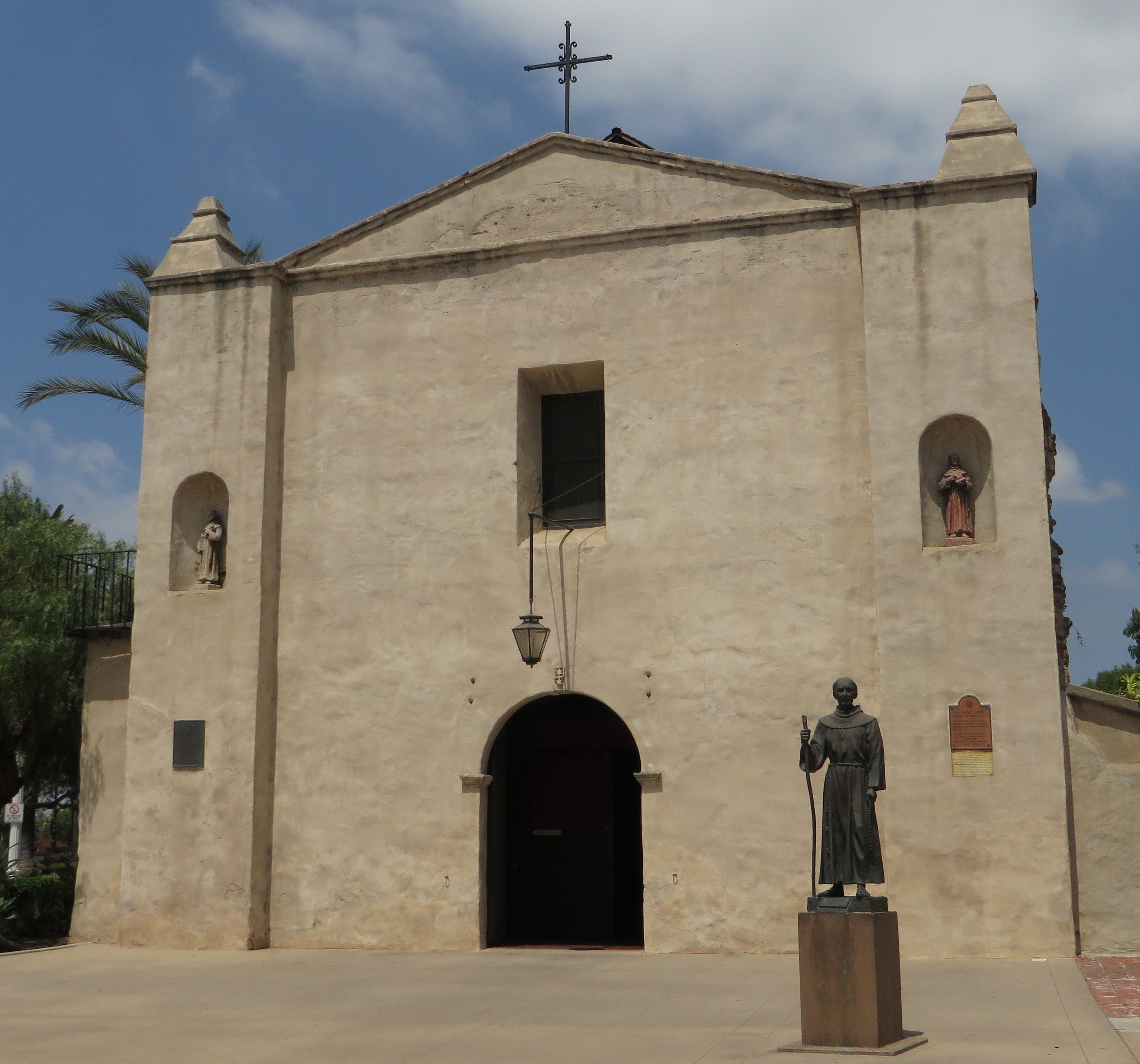
San Gabriel was founded by the Spanish in 1771, when Mission San Gabriel Arcángel was established by Saint Junípero Serra. Through the Spanish and Mexican periods, San Gabriel played an important role in the development of Los Angeles and Californio society. Owing to the prominence of Mission San Gabriel in the region's history, it is often called the "birthplace of the Los Angeles region".
History

_(cropped).jpg)
Tongva
Prior to the arrival of the Spanish to Alta California, the area that is San Gabriel were inhabited by the Tongva, whom the Spanish called the Gabrieleño. The Tongva village of Shevaanga was located at the original site of Mission San Gabriel, before being moved to the site of another village, Toviscanga, in 1776 after being destroyed by a flood. These villages were part of an extensive trade network and were interconnected by a series of trails.
Spanish period
Mission San Gabriel Arcángel, founded by Father Junípero Serra in 1771, is the fourth of twenty-one California Missions, and is known as the "Pride of the California Missions." Dissidence and rebellions against the mission by the Tongva, who were forced to labor at the mission, were common. After the Spanish missionaries banned converts to Christianity from dancing and participating in ceremony, a major rebellion of eight villages was staged against the mission in 1785 led by Toypurina and Nicolás Josè.
Mexican period
The Mission San Gabriel Arcángel served a pivotal role in the Californio society, with many of the area's first Mexican settlers being baptized at the mission, including future governor Pio Pico, who was born in 1801 at the mission and baptized there the same year. He was appointed as California's governor twice, serving briefly in 1832 and again from 1845 through the Mexican–American War. Later in life, he was elected as a Los Angeles City councilman. The city of Pico Rivera was named to honor him as the last governor of California to be born in Mexico.
American period
In 1853, a company of Army Engineers, which included the geologist William P. Blake, passed by the mission in search of the best route for an intercontinental railroad. Blake observed that the once great vineyards had fallen into wild disarray. Fences were in disrepair and animals roamed freely through the property. But the mission bells were ringing and the church was still in use. Blake predicted, "I believe that when the adaptation of that portion of California to the culture of the grape and the manufacture of wine becomes known and appreciated, the state will become celebrated not only for its gold and grain, but (also) for its fruits and wines."
In the first United States census made in California in 1860, 586 people lived in the San Gabriel township, an area encompassing the mission lands and several adjacent ranchos stretching north to what is now Pasadena. By 1870, the population had shrunk to 436.
San Gabriel incorporated as a city April 24, 1913, with a population of 1,500.
Geography

According to the United States Census Bureau, the city has a total area of 4.1 sqmi, virtually all of it land.
The city is located in the San Gabriel Valley and is bordered on the north by San Marino, on the east by Temple City and Rosemead, to the south by Rosemead and to the west by Alhambra.
Parks
.jpg)
The Parks and Recreation Department offers an after school sports program and a summer playground program for San Gabriel youth. Along with these programs, the department provides a variety of trips and special events throughout the year for youth of all ages.
Parks include:
- Adult Recreation Center and Senior Center, 324 South Mission Drive
- Bovard-Wilson-Hayes House and Jail
- Grapevine Park and Arbor, 324 South Mission Drive
- Smith Park and Pool, 232 West Broadway,
- Vincent Lugo Park, Corner of Wells and Ramona Streets
Climate
According to the Köppen Climate Classification system, San Gabriel has a hot-summer Mediterranean climate, abbreviated "Csa" on climate maps. Summers are hot and very dry, and winters are mild.
| Jan record high F = 94 | Feb record high F = 94 | Mar record high F = 101 | Apr record high F = 106 | May record high F = 106 | Jun record high F = 111 | Jul record high F = 108 | Aug record high F = 112 | Sep record high F = 112 | Oct record high F = 108 | Nov record high F = 101 | Dec record high F = 96 | year record high F = 112 | Jan avg record high F = 84.8 | Feb avg record high F = 85.6 | Mar avg record high F = 87.4 | Apr avg record high F = 93.2 | May avg record high F = 92.5 | Jun avg record high F = 95.2 | Jul avg record high F = 98.7 | Aug avg record high F = 100.7 | Sep avg record high F = 102.5 | Oct avg record high F = 98.0 | Nov avg record high F = 90.1 | Dec avg record high F = 82.9 | year avg record high F = 106.2 | Jan avg record low F = 33.9 | Feb avg record low F = 35.7 | Mar avg record low F = 38.5 | Apr avg record low F = 41.8 | May avg record low F = 48.1 | Jun avg record low F = 52.8 | Jul avg record low F = 57.1 | Aug avg record low F = 56.1 | Sep avg record low F = 54.2 | Oct avg record low F = 47.0 | Nov avg record low F = 38.6 | Dec avg record low F = 33.3 | year avg record low F = 31.8 | Jan record low F = 22 | Feb record low F = 25 | Mar record low F = 31 | Apr record low F = 34 | May record low F = 38 | Jun record low F = 43 | Jul record low F = 46 | Aug record low F = 47 | Sep record low F = 42 | Oct record low F = 33 | Nov record low F = 30 | Dec record low F = 24 | year record low F = 22
|access-date = May 7, 2023 |access-date = May 7, 2023
Demographics
1860–1870 1880-1890 1900 1910 1920 1930 1940 1950 1960 1970 1980 1990 2000 2010 2020
San Gabriel first appeared as a city in the 1920 U.S. census. In prior years, the area was part of the unincorporated portion of the now defunct San Gabriel Township (pop. 8,550 in 1910 and 2,501 in 1900).
| Race / Ethnicity (NH = Non-Hispanic) | title=P004: Hispanic or Latino, and Not Hispanic or Latino by Race – 2000: DEC Summary File 1 – San Gabriel city, California | url=https://data.census.gov/table?g=160XX00US0667042&tid=DECENNIALSF12000.P004 | website=United States Census Bureau | access-date= }} | title=P2: Hispanic or Latino, and Not Hispanic or Latino by Race – 2010: DEC Redistricting Data (PL 94-171) – San Gabriel city, California | url=https://data.census.gov/cedsci/table?q=p2&g=160XX00US0667042&tid=DECENNIALPL2010.P2 | website=United States Census Bureau | access-date= }} | % 2000 | % 2010 |
|---|---|---|---|---|---|---|---|---|---|---|
| White alone (NH) | 6,930 | 4,539 | 3,381 | 17.41% | ||||||
| Black or African American alone (NH) | 360 | 337 | 355 | 0.90% | ||||||
| Native American or Alaska Native alone (NH) | 129 | 55 | 42 | 0.32% | ||||||
| Asian alone (NH) | 19,399 | 23,994 | 25,068 | 48.74% | ||||||
| Native Hawaiian or Pacific Islander alone (NH) | 28 | 26 | 16 | 0.07% | ||||||
| Other race alone (NH) | 51 | 44 | 100 | 0.13% | ||||||
| Mixed race or Multiracial (NH) | 684 | 534 | 728 | 1.72% | ||||||
| Hispanic or Latino (any race) | 12,223 | 10,189 | 9,878 | 30.71% | ||||||
| Total | 39,804 | 39,718 | 39,568 | 100.00% |
2020
The 2020 United States census reported that San Gabriel had a population of 39,568. The population density was 9,548.3 PD/sqmi. The racial makeup of San Gabriel was 12.6% White, 1.0% African American, 0.9% Native American, 63.7% Asian, 0.1% Pacific Islander, 12.4% from other races, and 9.2% from two or more races. Hispanic or Latino of any race were 25.0% of the population.
The census reported that 98.5% of the population lived in households, 0.4% lived in non-institutionalized group quarters, and 1.1% were institutionalized.
There were 12,890 households, out of which 32.0% included children under the age of 18, 49.9% were married-couple households, 4.7% were cohabiting couple households, 27.9% had a female householder with no partner present, and 17.6% had a male householder with no partner present. 17.1% of households were one person, and 6.8% were one person aged 65 or older. The average household size was 3.02.
The age distribution was 17.0% under the age of 18, 8.2% aged 18 to 24, 27.3% aged 25 to 44, 29.8% aged 45 to 64, and 17.7% who were 65years of age or older. The median age was 42.8years. For every 100 females, there were 91.3 males.
There were 13,461 housing units at an average density of 3,248.3 /mi2, of which 12,890 (95.8%) were occupied. Of these, 45.9% were owner-occupied, and 54.1% were occupied by renters.
In 2023, the US Census Bureau estimated that the median household income was $87,592, and the per capita income was $38,157. About 11.4% of families and 12.3% of the population were below the poverty line.
2010
_(cropped).jpg)
_(cropped).jpg)
The 2010 United States census reported that San Gabriel had a population of 39,718. The population density was 9,581.5 PD/sqmi. The racial makeup of San Gabriel was 24,091 (60.7%) Asian, 10,076 (25.4%) White (11.4% Non-Hispanic White), 388 (1.0%) African American, 220 (0.6%) Native American, 43 (0.1%) Pacific Islander, 3,762 (9.5%) from other races, and 1,138 (2.9%) from two or more races. Hispanic or Latino of any race were 10,189 persons (25.7%).
The Census reported that 39,266 people (98.9% of the population) lived in households, 34 (0.1%) lived in non-institutionalized group quarters, and 418 (1.1%) were institutionalized.
There were 12,542 households, out of which 4,542 (36.2%) had children under the age of 18 living in them, 6,668 (53.2%) were opposite-sex married couples living together, 1,961 (15.6%) had a female householder with no husband present, 965 (7.7%) had a male householder with no wife present. There were 481 (3.8%) unmarried opposite-sex partnerships, and 76 (0.6%) same-sex married couples or partnerships. 2,121 households (16.9%) were made up of individuals, and 800 (6.4%) had someone living alone who was 65 years of age or older. The average household size was 3.13. There were 9,594 families (76.5% of all households); the average family size was 3.47.
The population was spread out, with 7,866 people (19.8%) under the age of 18, 3,555 people (9.0%) aged 18 to 24, 11,335 people (28.5%) aged 25 to 44, 11,388 people (28.7%) aged 45 to 64, and 5,574 people (14.0%) who were 65 years of age or older. The median age was 40.3 years. For every 100 females, there were 93.2 males. For every 100 females age 18 and over, there were 90.6 males.
There were 13,237 housing units at an average density of 3,193.3 /sqmi, of which 6,168 (49.2%) were owner-occupied, and 6,374 (50.8%) were occupied by renters. The homeowner vacancy rate was 1.0%; the rental vacancy rate was 5.7%. 19,974 people (50.3% of the population) lived in owner-occupied housing units and 19,292 people (48.6%) lived in rental housing units.
Ancestry
According to the Los Angeles Times, Chinese and Mexican were the most ancestries in 2000, with 52.6% of residents foreign born, Vietnam and China being the most common places of birth.
Economy
Top employers
.jpg)
_(cropped).jpg)
According to the city's 2019 Comprehensive Annual Financial Report, the top employers in the city are:
| # | Employer | # of Employees |
|---|---|---|
| 1 | AHMC San Gabriel Valley Medical | 1062 |
| 2 | Landwin Hospitality LLC | 150 |
| 3 | Ivy Creek Healthcare & Wellness Centre | 147 |
| 4 | SGV Healthcare Inc. | 147 |
| 5 | 99 Ranch Market #208 | 143 |
| 6 | Royal Vista Care Center, LLC | 123 |
| 7 | San Gabriel Country Club | 120 |
| 8 | Pine Grove Healthcare & Wellness Centre | 116 |
| 9 | Five Star Seafood Restaurant | 105 |
| 10 | San Gabriel Superstore | 105 |
Government
.jpg)
In the state legislature San Gabriel is located in , and in .
In the United States House of Representatives, San Gabriel is in .

City
Five councilmembers are elected by the voters to serve a four-year term. The Mayor is appointed annually by the Council in a rotation among its members. The City Council is also the Redevelopment Agency Board of Directors. As of July 2024, the members are Mayor John Wu, Vice Mayor Denise Menchaca, and Councilmembers Eric Chan, Tony Ding, and John R. Harrington.
The city's first Chinese American mayor was Chi Mui in 2006. He symbolized San Gabriel's rise as the new center of the region's Chinese community. He died of cancer three months later. Mui was replaced by Albert Y. M. Huang, who served as mayor during his term. Huang submitted his resignation October 19, 2010, following a late-night domestic dispute with his girlfriend and subsequent arrest. Huang has since been cleared of all charges.
Politics
San Gabriel is solidly Democrat at the presidential level. Although, there was a notable trend towards the Republican party from 2016 to 2024. This followed a trend towards the Democrats from 2008 to 2016.
Education
.jpg)

The vast majority of the city of San Gabriel is served by the San Gabriel Unified School District. It has five of the public elementary schools, Jefferson Middle School, Gabrielino High School, Del Mar High School, which opened in 2010, is an alternative high school.
A portion of San Gabriel is in the Garvey School District and the Alhambra Unified School District. Two elementary schools that exist within the city limits are operated by the Garvey School District, in the southern portion of San Gabriel. San Gabriel High School is operated by Alhambra USD .
A portion of San Gabriel is in the Rosemead Elementary School District and the El Monte Union High School District.
San Gabriel Mission High School is a Catholic, all girls school.
Media
San Gabriel community news are covered by the San Gabriel Valley Tribune, a paid daily newspaper, as well as by Mid-Valley News and San Gabriel Sun, which are community weeklies.
The independent, non-corporate community newspaper Colorado Boulevard Newspaper covers the city of San Gabriel both in print and online, along with neighboring cities in the western San Gabriel Valley.
Culture
.jpg)
The city has a mixture of Asian, European, and North American cultures. Second- and third-generation Chinese Americans patronize its diverse array of stores and eateries.
There is the 12 acre "San Gabriel Square" mall, sometimes referred to as the "Chinese Disneyland". It was also nicknamed by the Los Angeles Times as "the great mall of China." This stretch of Chinese shops and bold architecture, with roofs of Spanish-style tile, is the model for the new ethnoburbs recently recognized in places like Las Vegas and Houston.
Transportation
.jpg)

San Gabriel is currently served by the Los Angeles County Metropolitan Transportation Authority.
In 2008, voters approved the measure, proposition 1A for the California High Speed Rail Project from San Diego to San Francisco. The project will be constructed in two segments. The San Francisco to Los Angeles/Anaheim project is scheduled to be built first, at a cost of $43 billion, with a completion date in 2029. The second phase of the proposed railway, from Los Angeles to stations in San Diego will not begin construction until after phase one is completed. The California High-Speed Rail Authority is responsible for planning, designing, and building the system.
Conceptually, the voters were very enthusiastic about a high speed railway. The reality of the possibility that it could impact their neighborhood and their homes is being met with steadfast disapproval. When the California High-Speed Rail Authority recently met with the city councils and residents of San Gabriel, El Monte, Rosemead and Alhambra, to discuss the four proposed routes for phase two, the members of the three city councils expressed that residents were very concerned that the railway could possibly end up in their backyards. Mayor David Gutierrez said, "We made a promise to the community that the city of San Gabriel will never allow anything like this to happen if there is any consideration that people might lose their home." No decisions will be made until environmental impact and evaluation of the various proposed routes are completed in 2014.
Notable people
- Rick Aguilera, Major League Baseball pitcher, was born in San Gabriel
- Hank Aguirre, Major League Baseball pitcher
- Susan Atkins, convicted murderer, associate of Charles Manson
- Judge Roy Bean, notorious Wild West figure
- Jesse Chavez, Major League Baseball pitcher
- Francisco Dumetz, missionary
- Mike Garcia, Major League Baseball pitcher
- Curly Howard, comedian and actor
- Ward Kimball, animator for Disney
- Mike Krukow, Major League Baseball pitcher and TV commentator
- Billy Laughlin, child actor
- Dee Luong, poker player
- Gary McCord, pro golfer and TV commentator
- Angela Morales, writer
- Bill Mumy, actor
- Danny Patterson, Major League Baseball pitcher
- George S. Patton, World War II general
- Pio Pico, last Mexican Governor of California
- Luis J. Rodriguez, poet and writer
- Allan Sandage, astronomer
- Tex Schramm, original general manager of the Dallas Cowboys; born in San Gabriel
- Laurence Trimble, silent film actor
- Louis Vitale, priest and peace activist
- Kurt Vollers, pro football player
- Joanna Wang, singer-songwriter
Sister cities
- ROC Changhua City (Changhua County, Taiwan) - (since 1986)
References
References
- (2024). "City Council". City of San Gabriel.
- "Office of the City Manager". City of San Gabriel.
- "2020 U.S. Gazetteer Files". United States Census Bureau.
- {{Cite GNIS. 1656614. San Gabriel
- "US Census Bureau".
- "USPS - ZIP Code Lookup - Find a ZIP+ 4 Code By City Results".
- "Number Administration System - NPA and City/Town Search Results".
- "History of San Gabriel".
- (1907). "University of California Publications in American Archaeology and Ethnology". University of California.
- (1957). "The Masterkey, Volume 31". Southwest Museum.
- "City of San Gabriel, California, Comprehensive Annual Financial Report, Year ended June 30, 2009". City of San Gabriel.
- Street, Richard Steven. (2004). "Beasts of the Field: A Narrative History of California Farmworkers, 1769-1913". Stanford University Press.
- (October 16, 2018). "Forging Communities in Colonial Alta California". University of Arizona Press.
- "Pio Pico - Last Governor of Mexican California". laalmanac.com.
- "Frequently Asked Questions: Pico Rivera". [[County of Los Angeles Public Library]].
- Gally, Sid. (March 9, 2010). "Past on Parade: What was the San Gabriel Valley like in 1853?". [[Pasadena Star-News]].
- Paul R. Spitzzeri. (Fall 2007). "What a Difference a Decade Makes: Ethnic and Racial Demographic Change in Los Angeles County during the 1860s". Branding Iron.
- U.S. Census Bureau. "Population of the United States in 1860: California".
- "Population and Housing Unit Estimates". United States Census Bureau.
- "Decennial Census by Decade".
- "1870 Census of Population - Population of Civil Divisions less than Counties - California - Almeda County to Sutter County".
- "1870 Census of Population - Population of Civil Divisions less than Counties - California - Tehama County to Yuba County".
- "1890 Census of Population - Population of California by Minor Civil Divisions".
- "1900 Census of Population - Population of California by Counties and Minor Civil Divisions".
- "1910 Census of Population - Supplement for California".
- "1920 Census of Population - Number of Inhabitants - California".
- "1930 Census of Population - Number and Distribution of Inhabitants - California".
- "1940 Census of Population - Number of Inhabitants - California".
- "1950 Census of Population - Number of Inhabitants - California".
- "1960 Census of Population - General population Characteristics - California".
- "1960 Census of Population - Number of Inhabitants - California".
- "1970 Census of Population - Number of Inhabitants - California".
- "1980 Census of Population - Number of Inhabitants - California".
- "1990 Census of Population - Population and Housing Unit Counts - California".
- "2000 Census of Population - Population and Housing Unit Counts - California".
- "2010 Census of Population - Population and Housing Unit Counts - California".
- "P004: Hispanic or Latino, and Not Hispanic or Latino by Race – 2000: DEC Summary File 1 – San Gabriel city, California".
- "P2: Hispanic or Latino, and Not Hispanic or Latino by Race – 2010: DEC Redistricting Data (PL 94-171) – San Gabriel city, California".
- "P2: Hispanic or Latino, and Not Hispanic or Latino by Race – 2020: DEC Redistricting Data (PL 94-171) – San Gabriel city, California".
- "San Gabriel city, California; DP1: Profile of General Population and Housing Characteristics - 2020 Census of Population and Housing".
- "San Gabriel city, California; P16: Household Type - 2020 Census of Population and Housing".
- "San Gabriel city, California; DP03: Selected Economic Characteristics - 2023 ACS 5-Year Estimates Comparison Profiles".
- "2010 Census Interactive Population Search: CA - San Gabriel city". U.S. Census Bureau.
- "San Gabriel". [[Los Angeles Times]].
- (June 30, 2019). "Comprehensive Annual Financial Report". City of San Gabriel.
- "Final Maps {{!}} California Citizens Redistricting Commission".
- {{Cite GovTrack. CA. 28
- "City Council". City of San Gabriel.
- https://www.lavote.gov/home/voting-elections/current-elections/election-results/past-election-results
- "2020 CENSUS - SCHOOL DISTRICT REFERENCE MAP: Los Angeles County, CA". [[U.S. Census Bureau]].
- "San Gabriel Unified School District Listing". sgusd.k12.ca.us.
- "Del Mar High School". delmar.sgusd.k12.ca.us.
- "Points of Interest". City of San Gabriel.
- Pierson, David. (March 31, 2006). "Dragon Roars in San Gabriel". [[Los Angeles Times]].
- (November 12, 1992). "Cook's Walks: The Great Mall of China". Los Angeles Times.
- "Welcome To The San Gabriel Square".
- Shyong, Frank. (February 27, 2023). "How renovation of an iconic Chinese mall represents a shift in L.A.'s Chinese community". Los Angeles Times.
- "San Gabriel hears from Rail Authority and residents".
- (March 2025). "Residents Oppose HighSpeed Railway in Alhambra Monday Night". San Marino Tribune}}{{dead link.
- (February 17, 2009). "McConnell picks baseball's best ever".
- "Bill Mumy Biography (1954-)".
- (July 16, 2003). "Tex Schramm Is Dead at 83; Builder of 'America's Team". The New York Times.
- "Joanna Wang Lyrics".
This article was imported from Wikipedia and is available under the Creative Commons Attribution-ShareAlike 4.0 License. Content has been adapted to SurfDoc format. Original contributors can be found on the article history page.
Ask Mako anything about San Gabriel, California — get instant answers, deeper analysis, and related topics.
Research with MakoFree with your Surf account
Create a free account to save articles, ask Mako questions, and organize your research.
Sign up freeThis content may have been generated or modified by AI. CloudSurf Software LLC is not responsible for the accuracy, completeness, or reliability of AI-generated content. Always verify important information from primary sources.
Report