From Surf Wiki (app.surf) — the open knowledge base
Salyan District, Nepal
District of Karnali Province,Nepal
District of Karnali Province,Nepal
| Field | Value |
|---|---|
| type | District |
| name | Salyan District |
| native_name | सल्यान जिल्ला |
| native_name_lang | |
| image_skyline | Himalayen seen from chaya chetra , Salayan.JPG |
| image_caption | View of the Himalayas from Chhayachhetra |
| image_map | Salyan Karnali locator.png |
| map_caption | Location of Salyan District (dark yellow) in Karnali |
| subdivision_type | Country |
| subdivision_name | |
| subdivision_type1 | Province |
| parts_type | Municipality |
| parts_style | coll |
| established_title | Established |
| seat_type | Admin HQ. |
| seat | Salyan (today part of Shaarda Municipality) |
| leader_title | Head |
| leader_title1 | Deputy-Head |
| leader_title2 | Parliamentary constituencies |
| leader_title3 | Provincial constituencies |
| government_type | Coordination committee |
| governing_body | DCC, Salyan |
| area_total_km2 | 1462 |
| population_total | 241,716 |
| population_as_of | 2011 |
| population_density_km2 | auto |
| blank_name_sec1 | Main Language(s) |
| blank_info_sec1 | Nepali, English, Newari |
| blank_name_sec2 | Major highways |
| timezone1 | NPT |
| utc_offset1 | +05:45 |
| postal_code_type | Postal Codes |
| area_code_type | Telephone Code |
| website |
Salyan District ( IPA: [sʌljan]) in Karnali Province, is one of the seventy-seven districts of Nepal. Salyan covers an area of 1,462 km2 with a population of 213,500 in 2001 and 241,716 in 2011. The district's administrative center is named Salyan or Salyan Khalanga, today it is part of Shaarada Municipality.
The district is known for its Hindu temples including Shiva temples in Chhayachhetra and Laxmipur, and the Devi temple at Khairabang in Shaarada municipality, one of nine in Nepal.
History
Salyan was one of the Baise Rajya, a confederation of 22 petty kingdoms in the Karnali (Ghagra) region. It was ruled by Samala Shahis before unification. About 1760 CE all these kingdoms were annexed by the Shah Dynasty during the unification of Nepal.
Etymology
Salyan derives from the Nepali word sallo which means pine tree or conifer.
Geography and climate
Although Salyan is considered a hilly district, its southwest salient is actually outside the Pahari-inhabited hill region, in the lower Siwalik Hills that are more an extension of the Terai.
The Babai River flows through the southwestern Siwaliks section after draining Dang Valley. A tributary Sharad Khola drains the eastern half of Salyan's hill region—including the district center, then exits these hills by cutting through the Mahabharat Range to its confluence with the Babai. The western half of Salyan's hill region is drained by the Bheri.
| Climate zone | Elevation range | % of area |
|---|---|---|
| title = The Map of Potential Vegetation of Nepal - a forestry/agroecological/biodiversity classification system | series = Forest & Landscape Development and Environment Series 2-2005 and CFC-TIS Document Series No.110. | year = 2005 |
| Upper tropical | 300 to 1,000 meters | |
| 1,000 to 3,300 ft. | 28.6% | |
| Subtropical | 1,000 to 2,000 meters | |
| 3,300 to 6,600 ft. | 68.3% | |
| Temperate | 2,000 to 3,000 meters | |
| 6,400 to 9,800 ft. | 3.0% |
Demographics
At the time of the 2021 Nepal census, Salyan District had a population of 238,515. 9.68% of the population is under 5 years of age. It has a literacy rate of 77.30% and a sex ratio of 1074 females per 1000 males. 101,624 (42.61%) lived in municipalities.
Khas people make up a majority of the population with 84% of the population. Chhetris form an outright majority in the district with 59% of the population, while Khas Dalits make up 16% of the population. Magars make up 15% of the population.
At the time of the 2021 census, 98.26% of the population spoke Nepali and 1.02% Magar Kham as their first language. In 2011, 99.4% of the population spoke Nepali as their first language.
Population by census 1971–2021
Source:
Colors= id:lightgrey value:gray(0.9) id:darkgrey value:gray(0.8) id:sfondo value:rgb(1,1,1) id:barra value:rgb(0.6,0.7,0.8)
ImageSize = width:350 height:303 PlotArea = left:50 bottom:50 top:30 right:30 DateFormat = x.y Period = from:0 till:300000 TimeAxis = orientation:vertical AlignBars = justify ScaleMajor = gridcolor:darkgrey increment:50000 start:0 ScaleMinor = gridcolor:lightgrey increment:1000 start:0 BackgroundColors = canvas:sfondo
BarData= bar:1971 text:1971 bar:1981 text:1981 bar:1991 text:1991 bar:2001 text:2001 bar:2011 text:2011 bar:2021 text:2021 PlotData= color:barra width:20 align:left bar:1971 from: 0 till:141457 bar:1981 from: 0 till:152063 bar:1991 from: 0 till:181785 bar:2001 from: 0 till:213500 bar:2011 from: 0 till:241716 bar:2021 from: 0 till:238668 PlotData=
bar:1971 at:141457 fontsize:XS text:141,457 shift:(-14,5) bar:1981 at:152063 fontsize:XS text:152,063 shift:(-14,5) bar:1991 at:181785 fontsize:XS text:181,785 shift:(-14,5) bar:2001 at:213500 fontsize:XS text:213,500 shift:(-14,5) bar:2011 at:241716 fontsize:XS text:241,716 shift:(-14,5) bar:2021 at:238668 fontsize:XS text:238,668 shift:(-14,5)
Administration
The district consists of ten municipalities, out of which three are urban municipalities and seven are rural municipalities:
- Shaarda Municipality
- Bagchaur Municipality
- Bangad Kupinde Municipality
- Kalimati Rural Municipality
- Tribeni Rural Municipality
- Kapurkot Rural Municipality
- Chatreshwari Rural Municipality
- Kumakh Rural Municipality
- Siddha Kumakh Rural Municipality
- Darma Rural Municipality
Former village development committees
Prior to the restructuring of the district, Saylan District consisted of the following municipalities and village development committees:
- Badagaun
- Bafukhola
- Bajh Kanda
- Bame Banghad
- Bhalchaur
- Chande
- Chhayachhetra
- Damachaur
- Dandagaun
- Darmakot
- Devasthal
- Jhajhari Pipal
- Dhakadam
- Dhanwang
- Hiwalcha
- Jhimpe
- Jimali
- Kabhrechaur
- Kajeri
- Kalagaun
- Kalimati Kalche
- Kalimati Rampur
- Kavra
- Khalanga
- Korbang Jhimpe
- Kotbara
- Kotmala
- Kubhinde
- Laxmipur
- Lekhpokhara
- Majh Khanda
- Marke
- Marmaparikanda
- Mulkhola
- Nigalchula
- Phalawang
- PipalNeta
- Rim
- Saijuwal Takura
- Sarpani Garpa
- Sibaratha
- Siddheswar
- Sinwang
- Suikot
- Syanikhal
- Tharmare
- Tribeni
- Halde Now kalimati Rular muncipatity 2
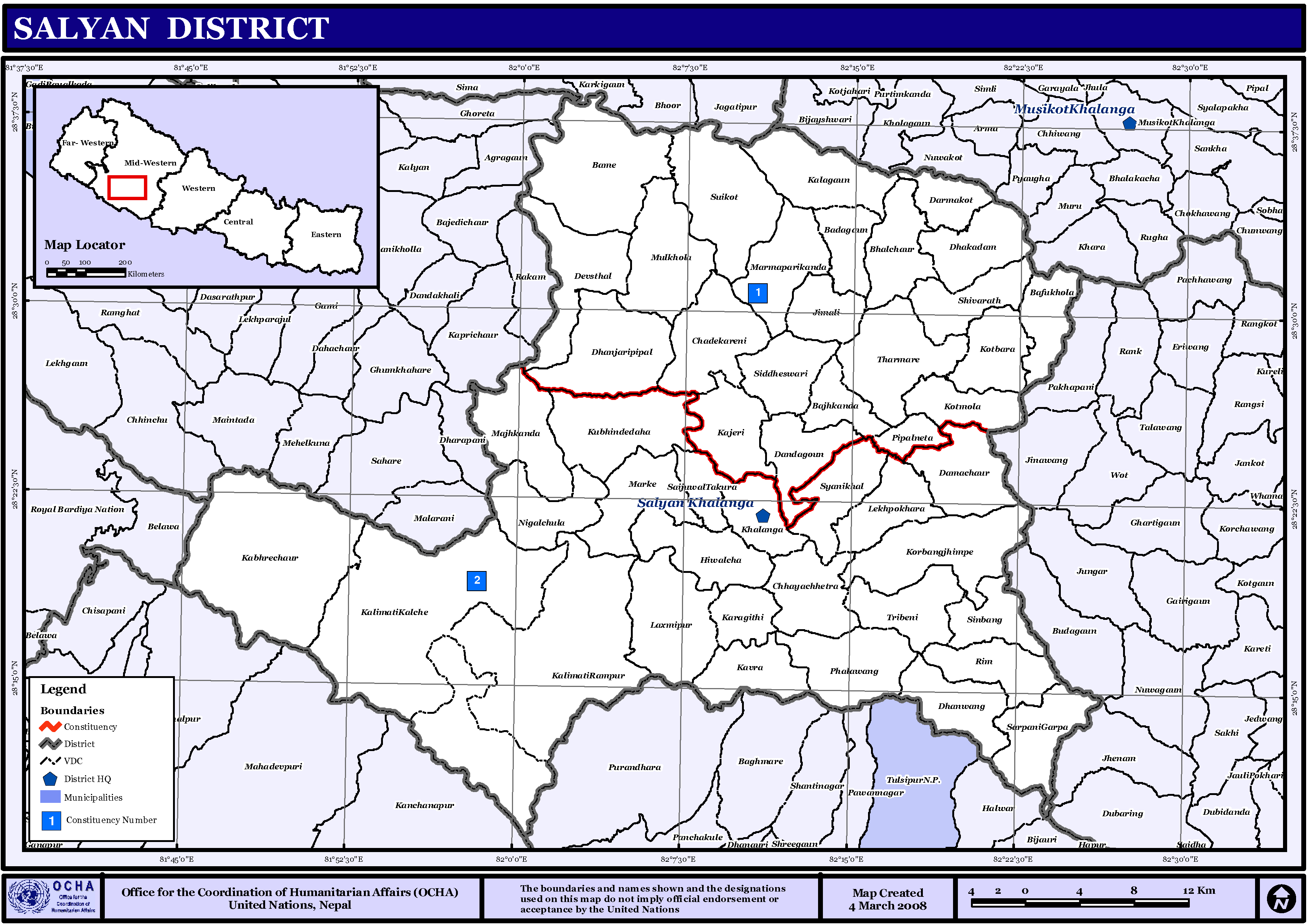
Maps
Besides the United Nations/Nepal map of districts and VDCs shown above, their Map Centre has a downloadable PDF version adding municipalities, roads and water detail: :{{cite map |map-url=http://www.un.org.np/sites/default/files/maps/district_maps/Salyan.pdf
From 1992 to 2002 a definitive series of large scale topographic maps were surveyed and published through a joint project by Government of Nepal Survey Department and Finland's Ministry for Foreign Affairs contracting through the FinnMap consulting firm. Japan International Cooperation Agency substituted for FinnMap in Lumbini Zone. Topographic sheets at 1:25,000 scale covering 7.5 minutes latitude and longitude map the Terai and Middle Mountains. Less populated high mountain regions are on 15 minute sheets at 1:50,000. JPG scans can be downloaded here:{{cite web |publisher=MyPublisher |title=Nepal-Topo Maps
- 2881 08D Bajedichaur (1999)
- 2881 11D Chisapani Mulatati (1997)
- 2881 12A Mehelkuna (1999)
- 2881 12B Botechaur (1999)
- 2881 12C Ghuiyabari (1998)
- 2881 12D Baluwa (1998)
- 2881 16A Dhakeri (1997)
- 2881 16B Dhobaghat (1997)
- 2882 05A Karkigau (1999)
- 2882 05C Salli Bajar (1999)
- 2882 05D Swikot (1999)
- 2882 06C Pharulachaur (1999)
- 2882 06D Simruth (1999)
- 2882 09A Kubhinde Daha (1999)
- 2882 09B Khalanga (1999)
- 2882 09C Suketal (1999)
- 2882 09D Shitalpati (1998)
- 2882 10A Tharmare (1999)
- 2882 10B Sukhaodar (1999)
- 2882 10C Luham (1998)
- 2882 10D Nerpa (1999)
- 2882 13A Hamsapur (1998)
- 2882 13B Panchakule (1998)
- 2882 14A Tulsipur (1999)
- 2882 14B Dubrin (1999)
References
References
- Central Bureau of Statistics, Kathmandu, Nepal, Jan. 2014
- Malla, Mohan. (December 1, 1979). "The Baise and Chaubise Principalities". Regmi Research Series.
- "Provincial/District/Local reports: Karnali Province". [[Central Bureau of Statistics (Nepal).
- "Table 1: Caste/Ethnicity and sex". [[Central Bureau of Statistics (Nepal).
- "Table 5: Mother tongue and sex". [[Central Bureau of Statistics (Nepal).
- link. (8 March 2023)
- "Table 5: Religion and sex". [[Central Bureau of Statistics (Nepal).
- "Districts of Nepal". Gwillim Law.
- (January 2014). "National Population and Housing Census 2011, Volume 3". Government of Nepal, Central Bureau of Statistics.
- "स्थानिय तह". Ministry of Federal Affairs and General Administration.
- "Map Centre". United Nations, Nepal Information Platform.
- "Government of Nepal, Survey Department".
- "Land Administration & Management, Mapping, Surveying and Aerial Photography, Major Reference Projects". FinnMap.
- "Japan International Cooperation Agency".
This article was imported from Wikipedia and is available under the Creative Commons Attribution-ShareAlike 4.0 License. Content has been adapted to SurfDoc format. Original contributors can be found on the article history page.
Ask Mako anything about Salyan District, Nepal — get instant answers, deeper analysis, and related topics.
Research with MakoFree with your Surf account
Create a free account to save articles, ask Mako questions, and organize your research.
Sign up freeThis content may have been generated or modified by AI. CloudSurf Software LLC is not responsible for the accuracy, completeness, or reliability of AI-generated content. Always verify important information from primary sources.
Report