From Surf Wiki (app.surf) — the open knowledge base
Saint Martin (island)
Small island in the Caribbean

Small island in the Caribbean
| Field | Value |
|---|---|
| name | Saint Martin |
| image_name | Saint Martin map.svg |
| map_image | Saint Martin in its region.svg |
| native_name | nl |
| fr | |
| nickname | The Friendly Island |
| location | Caribbean |
| coordinates | |
| archipelago | Leeward Islands, |
| Lesser Antilles, | |
| Antilles, West Indies | |
| area_km2 | 88 |
| highest_mount | Pic Paradis |
| elevation_m | 424 |
| country | France |
| country_admin_divisions_title | Collectivity |
| country_admin_divisions | Saint Martin |
| country_capital_and_largest_city | Marigot |
| country_largest_city_population | 5,788 |
| country_capital_type | settlement |
| country_area_km2 | 53 |
| country1 | Kingdom of the Netherlands |
| country1_admin_divisions_title | Constituent country |
| country1_admin_divisions | Sint Maarten |
| country1_capital | Philipsburg (pop. 1,900) |
| country1_largest_city | Lower Prince's Quarter |
| country1_largest_city_population | 8,123 |
| country1_capital_type | settlement |
| country1_area_km2 | 34 |
| population | 73,777 |
| population_as_of | Jan. 2019 |
| density_km2 | 847 |
| demonym | Saint Martiner; |
| fr; | |
| nl | |
| ethnic_groups | Afro-Caribbean, European, Indian, Latino, Chinese, and mixed |
the Caribbean island
fr Lesser Antilles, Antilles, West Indies fr; nl Saint Martin is an island in Leeward Islands of the Lesser Antilles in the northeastern Caribbean, approximately 300 km east of Puerto Rico. The 87 km2 island has been divided since 1648 roughly 60:40 between France (53 km2)
On 1 January 2019, the population of the whole island was 73,777 inhabitants, with 41,177 living on the Dutch side The population of the island on 1 January 2017, before Hurricane Irma, was 75,869 (40,535 on the Dutch side,).
The island's pre-colonial names include Oualichi (Arawakan, meaning 'the island of women') and Soualiga (Kalinago, meaning 'the island of salt').
Collectively, the two territories are known as "Saint-Martin / Sint Maarten", or sometimes "SXM", the IATA identifier for Princess Juliana International Airport, the island's main airport. St. Martin (the French portion) received the ISO 3166-1 code MF in October 2007. In 2010, the Dutch part had its status changed to that of a country within the Kingdom of the Netherlands and was given the code SX.
Geography
Saint Martin has a land area of 87 km2, 53 km2 of which is under the sovereignty of the French Republic, This is the only land border shared by the French Republic and the Kingdom of the Netherlands.
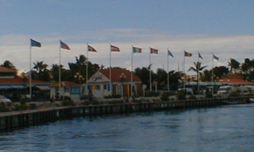
The main cities are Philipsburg on the Dutch side and Marigot on the French side. The Dutch side is more heavily populated. The most populous settlement on the entire island is Lower Prince's Quarter, on the Dutch side.
The highest hilltop is the Pic Paradis (424 m) in the centre of a hill chain on the French side. Both sides are hilly with large mountain peaks. This forms a valley where many houses are located. There are no rivers on the island, but there are many dry gullies. Hiking trails give access to the dry forest that covers tops and slopes. The 1648 Treaty of Concordia was signed on the hill lying on the international border between Marigot and Philipsburg, known as Mount Concordia, Concordia Hill, or Mont des Accords.
The island is located south of Anguilla and is separated from that British overseas territory by the Anguilla Channel. Saint Martin is northwest of Saint Barthélemy and is separated from that French overseas collectivity by the Saint-Barthélemy Channel.
Neighbouring islands include Saint Barthélemy (French), Anguilla (British), Saba (Dutch), Sint Eustatius "Statia" (Dutch), and Saint Kitts and Nevis (independent, formerly British).
History
Main article: History of Saint Martin, French West Indies, Dutch Caribbean
.svg)
It is commonly believed that Christopher Columbus named the island in honour of Saint Martin of Tours when he encountered it on his second voyage of discovery. However, he actually applied the name to the island now called Nevis when he anchored offshore on 11 November 1493, the feast day of Saint Martin. The confusion of numerous poorly charted small islands in the Leeward Islands meant that this name was accidentally transferred to the island now known as Saint-Martin/Sint Maarten.
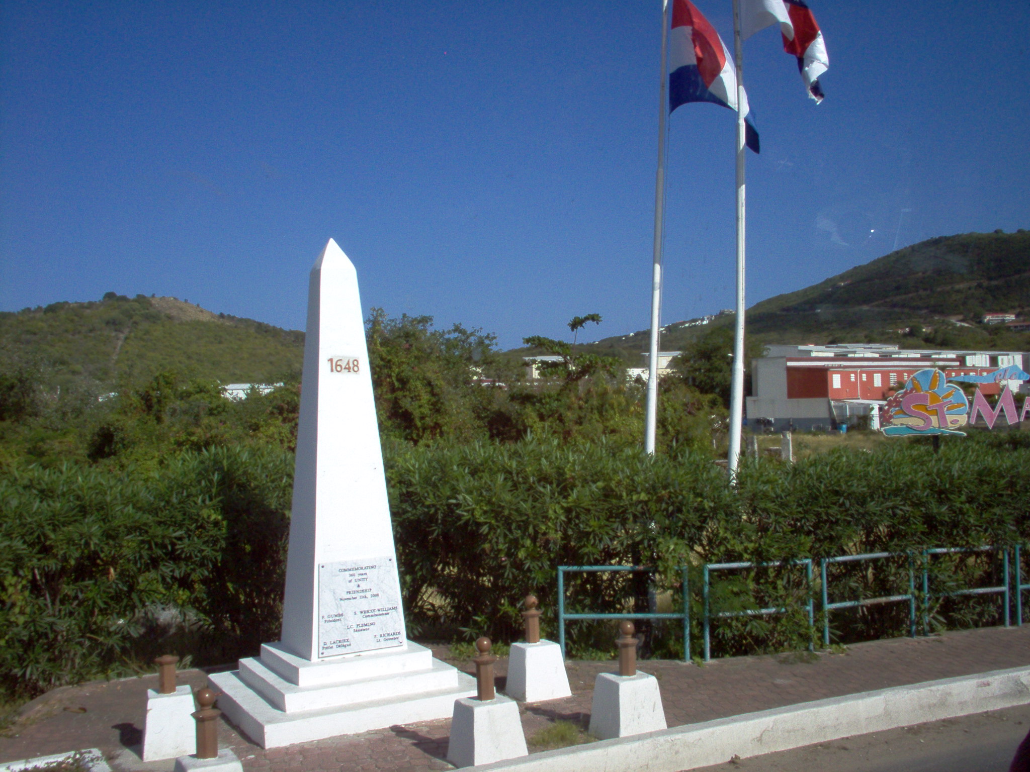
After jointly reclaiming the island, on 23 March 1648, the Kingdom of France and the Dutch Republic agreed to divide the island between their two territories, and created a formal border with the signing of the Treaty of Concordia. Later conflicts resulted in 16 border changes over the years, but it has been stable since 1816. The French side has 21 sqmi and the Dutch side, 16 sqmi.

Politics
There currently is a movement aiming to unite the Dutch and French halves of the island of Saint Martin. A "Unity Flag" for representing this unification was created in 1990.
Currently, the island is divided into Sint Maarten (the southern half of the island, part of the Netherlands) and the Collectivity of Saint Martin (the northern half of the island, part of France). The island has been divided since the signing of the Treaty of Concordia in 1648, which today remains as one of the oldest treaties still in effect. Unification of the island enjoys support from the population of both halves.
The Treaty of Concordia allows freedom of movement between both parts of the island, which has promoted a common sentiment among the island's inhabitants, although this is also the reason why some see a formal unification as unnecessary. Other arguments against unification of the island are that neither France nor the Netherlands would allow it and that both sides would require full independence to achieve it.
On 31 August 1990, the "Unity Flag" of Saint Martin was adopted at the Preliminary Conference on National Symbols at the Philipsburg Jubilee Library, in Sint Maarten. This flag was created to represent the people of both halves of the island and the unification of the latter, and is hoisted today on some houses and sometimes by churches and religious groups in Saint Martin. In August 2020, when restrictions and controls were added to the Saint Martin–Sint Maarten border to contain the COVID-19 pandemic, some protesters against these measures flew this flag with them. In September 2020, these restrictions were lifted, and people from both sides of the island started chanting "One island, one people, one destiny". Some notable supporters of this movement include Albert Fleming, former leader of the Collectivity of Saint Martin, who in 2014 stated his support for the unification of the island.
Climate
Under the Köppen climate classification, the island has a tropical savanna climate (Aw) with a dry season from January to April and a rainy season from August to December. The precipitation patterns are due to the movement of the Azores High during the year. With the wind direction predominantly from the east or the northeast, northeasterly trades, temperatures remain stable throughout the year and temperatures rarely exceed 34 °C or fall below 20 °C. Temperatures remain steady throughout the year with an average mean temperature of 27.2 C. The average sea temperature is 27.2 C ranging from a low of 25.9 C in February to a high of 28.4 C in October. The total average yearly rainfall is 1047 mm, with 142 days of measurable rainfall. Thunderstorms can occasionally occur, with 18 days with thunder per year. Precipitation totals are quite variable from year to year, depending on the number of passing tropical cyclones.
Because the island is located within the tropics, it is regularly threatened by Atlantic hurricane activity in the late summer and early fall.
Hurricane Irma (2017)
_05.jpg)
On 6 September 2017 the island was hit by Hurricane Irma (Category 5 at landfall), which caused widespread and significant damage, estimated at $3 billion, to buildings and infrastructure. A total of 11 deaths had been reported as of 9 July 2018. France's Minister of the Interior, Gérard Collomb, said on 8 September 2017 that most of the schools were destroyed on the French half of the island. In addition to damage caused by high winds, there were reports of serious flood damage to businesses in the village of Marigot. Looting was also a serious problem. Both France and the Netherlands sent aid as well as additional police and emergency personnel to the island. The Washington Post reported that 95% of the structures on the French side and 75% of the structures on the Dutch side were damaged or destroyed.
Some days after the storm had abated, a survey by the Dutch Red Cross estimated that nearly a third of the buildings in Sint Maarten had been destroyed and that over 90 per cent of structures on the island had been damaged. Princess Juliana Airport was extensively damaged but reopened on a partial basis in two days to allow incoming relief flights and for flights that would take evacuees to other islands.
Economy
Main article: Economy of Saint Martin
INSEE estimated that the nominal GDP of the French side of Saint Martin amounted to 582 million euros in 2014 (US$772 million at 2014 exchanges rates; US$660 million at Feb. 2022 exchange rates). The nominal GDP of the Dutch side of the island, Sint Maarten, was estimated at 2,229 million Antillean guilders (US$1,245 million at the official peg) in 2014. The nominal GDP of the entire island was thus US$2.01 billion in 2014.
The nominal GDP per capita of the entire island stood at US$27,923 in 2014.
The Dutch side of the island experienced a deep recession in 2017 and 2018 due to the devastation of Hurricane Irma which struck the island in September 2017. Real GDP experienced a negative growth of -5.8% in 2017 and -6.6% in 2018 (GDP figures after 2018 have not been published yet). GDP of the French side of the island has not been estimated since 2014.
The main industry of the island is tourism. In 2000, the island had about one million visitors annually. About 85% of the workforce was engaged in the tourist industry.
Demographics
On 1 January 2019, the population of the whole island was 73,777 inhabitants, with 41,177 living on the Dutch side Population of the island on 1 January 2017, before Hurricane Irma, was 75,869 (40,535 on the Dutch side, 35,334 on the French side).
Due to a major influx of immigrants searching for better employment and living conditions over the past 30 years, the number of Creoles has been surpassed by the number of immigrants. The island's population is highly diverse, containing people from more than 70 countries.
With so many nationalities present, quite a few languages are spoken. An English-based creole is the main local vernacular. However, the official languages are French for Saint-Martin, with Dutch and English being official for Sint Maarten. Other common languages include various French creoles (spoken by French Caribbean immigrants), Spanish (spoken by immigrants from the Dominican Republic, Puerto Rico, and various South American countries), and Papiamento (spoken by immigrants from Aruba, Bonaire and Curaçao).
The most practiced religion is Roman Catholicism in French Saint-Martin, and Protestant denominations in Dutch Sint Maarten, particularly Methodism. The island also has small Jewish, Seventh-day Adventist, Hindu, Muslim, Sikh, Buddhist, and Rastafari communities.
Culture
The island is known for its cuisine. including Creole, French, and West Indian cooking. St. Martin's Dutch side has casinos.
File:Philipsburg St Maarten.jpg|Simpson Bay, Sint Maarten, Dutch side File:Philipsburg and the Great Bay, Sint Maarten, Caribbean.jpg|Philipsburg and the Great Bay File:Marigot 2.jpg|Marigot, Saint Martin, French side File: Saint Maarten.jpg| Cole bay (taken atop sentry hill)
Currency
The official currency of Saint Martin is the euro. Sint Maarten uses the Netherlands Antillean guilder, pegged at 1.79 per US dollar. As a consequence of the dissolution of the Netherlands Antilles, the Netherlands Antillean guilder will cease to be legal tender and be replaced by the Caribbean guilder, which was originally scheduled for circulation in the first half of 2021, and then for 2024.
Transport
Border checks
Neither side of the island is part of the Schengen Area; full border checks are performed when travelling in and out of the island. Passport controls are also exercised when taking the ferry from Marigot or Princess Juliana International Airport to Anguilla. There are rarely checks at the border between the two sides of the island.
In 1994, the Kingdom of the Netherlands and France signed the Franco-Dutch treaty on Saint Martin border controls, which allows for joint Franco-Dutch border controls on so-called "risk flights" arriving from off-island and only admitting foreigners having permission to travel on both sides of the island. After some delay, the treaty was ratified in November 2006 in the Netherlands and subsequently entered into force on 1 August 2007. Its provisions are not yet implemented as the working group specified in the treaty is not yet installed. The Dutch side has expressed concern that new and tighter French visa requirements would harm their tourism income.
Airports
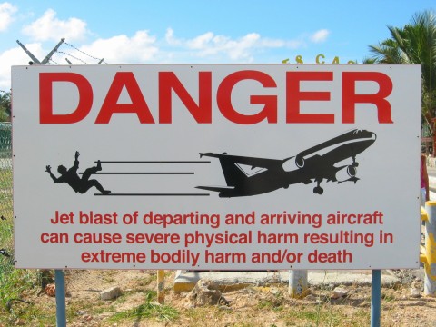
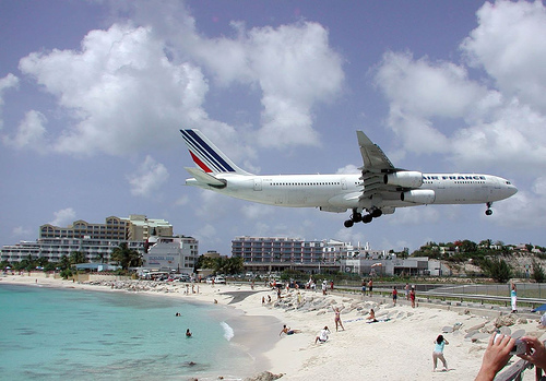
The island is served by the Princess Juliana International Airport, in the Dutch part of the island.
There is also a small airport on the French side of the island at Grand Case, L'Espérance Airport for small aircraft serving neighbouring Caribbean islands. It frequently suffers thick fog during the hurricane season due to its location.
Notes
References
Sources
References
- "Mise à jour du plan de prévention des risques naturels de la collectivité territoriale de Saint-Martin". [[Cabinet of France.
- "Statistical yearbook 2017". Department of Statistics, Sint Maarten.
- "Population Estimates and Vital Statistics 2021". Department of Statistics, Sint Maarten.
- "Populations légales des collectivités d'outre-mer en 2019". [[Cabinet of France.
- (29 August 2002). "12th anniversary of St. Martin's "Unity Flag" observed Saturday on Conscious Lyrics; students raise money for unity bumper stickers". House of Nehesi Publishers.
- and the [[Kingdom of the Netherlands]] ({{cvt. 34. km2. mi2. four constituent countries]] that form the [[Kingdom of the Netherlands]]. Even though the island is an overseas possession of two [[European Union]] member states, only the French part of the island is part of the EU.{{CELEX
- "Status Caribisch gebied".
- "Sint Maarten to start population census 2022 {{!}} Loop Caribbean News".
- "St. Martin". The Caribbean Pet.
- "History of St Maarten".
- ISO 3166-1 Newsletter.[http://www.iso.org/iso/newsletter_vi-1.pdf Assignment of code elements for Saint-Barthélemy and Saint-Martin and update of France and other French Territories.] {{Webarchive. link. (28 December 2016)
- ISO 3166-1 Newsletter. [http://www.iso.org/iso/country_codes/updates_on_iso_3166.htm Code elements for Bonaire, Saint Eustatius, and Saba, Curaçao, and Sint Maarten (Dutch part), update of other territories and minor corrections.] {{Webarchive. link. (24 May 2016)
- (2002). "A History of St Kitts". MacMillan Caribbean.
- (1974). "The European Discovery of America, The Southern Voyages". Oxford University Press.
- Frank Jacobs. (24 April 2012). "One Island, Two Countries". The New York Times.
- Satur Abón Pérez. (1980). "''Nueva Geografía Universal'', Tomo IX, América. (New Universal Geography, Volume IX, America)". Promexa.
- Badejo, Fabian Adekunle. (25 December 2004). "The reunification of St. Martin: A pipe dream or an inevitable choice?". House of Nehesi Publishers.
- (12 November 2020). "One island, two nations and a European Union: St. Martin". IACL-AIDC Blog.
- Steel, Jenny. (9 August 2020). "Protest at Saint Martin border: "you are basically blocking us from living"". Caribbean Network.
- Letuvée, Florent. (16 September 2020). "Frontière: L'unification qui fait la force? Pas que... Une victoire mais il reste la "crise" sanitaire à gérer". sxminfo.fr.
- (1 August 2014). "Former mayor Albert Fleming calls for unification of St. Martin north and south with the support of UP party candidate #5 Josianne Artsen". Saint Martin News Network.
- "Sain Martin". mindat.org.
- "Climate Summaries". Meteorological Department Curaçao.
- "Summary of Climatological Data, Period 1971–2000". Meteorological Department Curaçao.
- (2 March 2018). "St. Maarten is still striving to recover from its worst hurricane in a century".
- Davies, Caroline. (8 September 2017). "Caribbean islanders fear another battering after Irma wreaks havoc".
- (7 September 2017). "Caribbean Devastated as Irma Heads Toward Florida". The New York Times.
- (7 September 2018). "Revisited – Video: One year after Hurricane Irma, St Martin struggles to recover".
- "ABC News".
- [https://web.archive.org/web/20170909223210/https://www.washingtonpost.com/world/the_americas/dutch-officials-irma-damaged-or-destroyed-70-percent-of-st-maarten-homes-leaving-island-vulnerable-to-joses-approach/2017/09/09/666eb640-957e-11e7-8482-8dc9a7af29f9_story.html "Dutch officials: Irma damaged or destroyed 70 percent of St. Maarten homes, leaving island vulnerable to Jose’s approach"], ''Washington Post'', 9 September 2017. Accessed 9 September 2017.
- [http://newsinfo.inquirer.net/928557/hurricane-irma-destroys-95-of-french-part-of-st-martin-official "Hurricane Irma destroys ‘95%’ of French part of St. Martin—official"] {{Webarchive. link. (11 April 2023 , ''Agence France-Presse'', 7 September 2017. Accessed 9 September 2017.)
- (12 September 2017). "Third of buildings on Dutch St. Martin destroyed".
- (7 September 2017). "St. Martin's famous airport badly damaged by Hurricane Irma".
- (May 2018). "Estimation of per capita GDP in Saint-Martin". [[INSEE]].
- "GDP 2018 - Press Release". Department of Statistics, Sint Maarten.
- "Populations légales 2014 des départements et collectivités d'outre-mer". [[Cabinet of France.
- "CIA Factbook". Cia.gov.
- Holm (1989) ''Pidgins and Creoles'', vol. 2
- [http://www.st-maarten.com/culture.htm Culture of St. Maarten] {{webarchive. link. (6 December 2006. St. Maarten Tourism Office.)
- (April 2022). "What Are the Religions in Sint Maarten/Saint Martin?".
- "6 Date Ideas for a Romantic Getaway to St. Maarten".
- (17 June 2013). "Casinos". about-saintmartin.com.
- "Guavaberry Liqueur Deserves a Spot On Your Bar Cart".
- (15 November 2020). "Central Bank announces introduction of Caribbean Guilder in 2021". StMaartenNews.com.
- (January 2023). "CBCS moves ahead with the Introduction of the Caribbean Guilder".
- (22 June 2015). "Bus transit Saint-Martin". stmartinisland.org.
- "Immigration Formalities". About-saintmartin.com.
This article was imported from Wikipedia and is available under the Creative Commons Attribution-ShareAlike 4.0 License. Content has been adapted to SurfDoc format. Original contributors can be found on the article history page.
Ask Mako anything about Saint Martin (island) — get instant answers, deeper analysis, and related topics.
Research with MakoFree with your Surf account
Create a free account to save articles, ask Mako questions, and organize your research.
Sign up freeThis content may have been generated or modified by AI. CloudSurf Software LLC is not responsible for the accuracy, completeness, or reliability of AI-generated content. Always verify important information from primary sources.
Report