From Surf Wiki (app.surf) — the open knowledge base
Sacramento River
River in Northern and Central California, United States

River in Northern and Central California, United States
| Field | Value |
|---|---|
| name | Sacramento River |
| native_name | es |
| name_other | Rio del Santísimo Sacramento |
| image | File:Sacramento River.JPG |
| image_caption | Sacramento River from the old pumping station in Sacramento, California |
| image_size | 300 |
| map | Sacramento River basin map.png |
| map_size | 300 |
| map_caption | Map of the Sacramento River watershed |
| mapframe | yes |
| mapframe-zoom | 5 |
| subdivision_type1 | Country |
| subdivision_name1 | United States |
| subdivision_type2 | State |
| subdivision_name2 | California |
| subdivision_type3 | Cities |
| subdivision_name3 | Mount Shasta, Dunsmuir, Redding, Anderson, Red Bluff, Princeton, Colusa, Davis, Sacramento, West Sacramento, Isleton, Rio Vista, Antioch |
| length | 400 mi, North-south |
| discharge1_location | near Sacramento, CA |
| discharge1_min | 3970 cuft/s |
| discharge1_avg | 28139 cuft/s |
| discharge1_max | 489000 cuft/s |
| source1 | Confluence of Middle and South Forks |
| source1_location | Near Mount Shasta, Siskiyou County |
| source1_coordinates | |
| source1_elevation | 3674 ft |
| mouth | Suisun Bay |
| mouth_location | Contra Costa-Solano county line |
| mouth_coordinates | |
| mouth_elevation | 0 ft |
| basin_size | 26500 sqmi |
| tributaries_left | Pit River, Deer Creek, Butte Creek, Feather River, American River |
| tributaries_right | Clear Creek, Cottonwood Creek, Stony Creek, Cache Creek, Putah Creek |
| custom_label | Nicknames |
| custom_data | Sac River, Nile of the West |
the California river
| mapframe-zoom = 5
The Sacramento River () is the principal river of Northern California in the United States and is the largest river in California. Rising in the Klamath Mountains, the river flows south for 400 mi before reaching the Sacramento–San Joaquin River Delta and San Francisco Bay. The river drains about 26500 sqmi in 19 California counties, mostly within the fertile agricultural region bounded by the Coast Ranges and Sierra Nevada known as the Sacramento Valley, but also extending as far as the volcanic plateaus of Northeastern California. Historically, its watershed has reached as far north as south-central Oregon where the now, primarily, endorheic (closed) Goose Lake rarely experiences southerly outflow into the Pit River, the most northerly tributary of the Sacramento.
The Sacramento and its wide natural floodplain were once abundant in fish and other aquatic creatures, notably one of the southernmost large runs of chinook salmon in North America. For about 12,000 years, humans have depended on the vast natural resources of the watershed, which had one of the densest Native American populations in California. The river has provided a route for trade and travel since ancient times. Hundreds of tribes sharing regional customs and traditions have inhabited the Sacramento Valley, first coming into contact with European explorers in the late 1700s. The Spanish explorer Gabriel Moraga named the river Rio de los Sacramentos in 1808, later shortened and anglicized into Sacramento.
In the 19th century, gold was discovered on a tributary of the Sacramento River, starting the California Gold Rush and an enormous population influx to the state. Overland trails such as the California Trail and Siskiyou Trail guided hundreds of thousands of people to the gold fields. By the late part of the century mining had ceased to be a major part of the economy, and many immigrants turned to farming and ranching. Many populous communities were established along the Sacramento River, including the state capital of Sacramento. Intensive agriculture and mining contributed to pollution in the Sacramento River, and significant changes to the river's hydrology and environment.
Since the 1950s the watershed has been intensely developed for water supply and the generation of hydroelectric power. Today, large dams impound the river and almost all of its major tributaries. The Sacramento River is used heavily for irrigation and serves much of Central and Southern California through the canals of giant state and federal water projects. While it is now providing water to over half of California's population and supporting the most productive agricultural area in the nation, these changes have left the Sacramento greatly modified from its natural state and have caused the decline of its once-abundant fisheries.
Course
Upper river


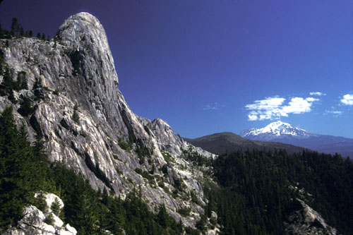
The Sacramento River originates in the mountains and plateaus of far northern California as three major waterways that flow into Shasta Lake: the Upper Sacramento River, McCloud River and Pit River. The Upper Sacramento begins near Mount Shasta, at the confluence of North, Middle and South Forks in the Trinity Mountains of Siskiyou County. It flows east into a small reservoir, Lake Siskiyou, before turning south. The river flows through a canyon for about 60 mi, past Dunsmuir and Castella, before emptying into Shasta Lake near Lakehead in Shasta County. The McCloud River rises on the east slope of Mount Shasta and flows south for 77 mi through the southern Cascade Range, roughly parallel to the Upper Sacramento, eventually to reach the McCloud Arm of Shasta Lake.{{cite map |access-date = February 19, 2016 |url-status = live |archive-url = https://web.archive.org/web/20080102075829/http://mapper.acme.com/ |archive-date = January 2, 2008
The Pit River, by far the largest of the three, begins in Modoc County in the northeastern corner of California. Draining a vast and remote volcanic highlands area, it flows southwest for nearly 300 mi before emptying into Shasta Lake near Montgomery Creek. Goose Lake, straddling the Oregon–California border, occasionally overflows into the Pit River during wet years, although this has not happened since 1881. The Goose Lake watershed is the only part of the Sacramento River basin extending into another state. Unlike most California rivers, the Pit and the McCloud Rivers are predominantly spring-fed, ensuring a large and consistent flow in even the driest of summers. At the lower end of Shasta Lake is Shasta Dam, which impounds the Sacramento River for flood control, irrigation and hydropower generation. Before the construction of Shasta Dam, the McCloud River emptied into the Pit River, which joined the Sacramento near the former mining town of Kennett, submerged when Shasta Lake was filled. The Pit River Bridge, which carries Interstate 5 and the Union Pacific Railroad over the reservoir, is structurally the highest double-decked bridge in the United States (although most of the bridge piers are submerged under Shasta Lake when the reservoir is full). The Upper Sacramento River canyon also provides the route for I-5 and the railroad between Lakehead and Mount Shasta.
Sacramento Valley
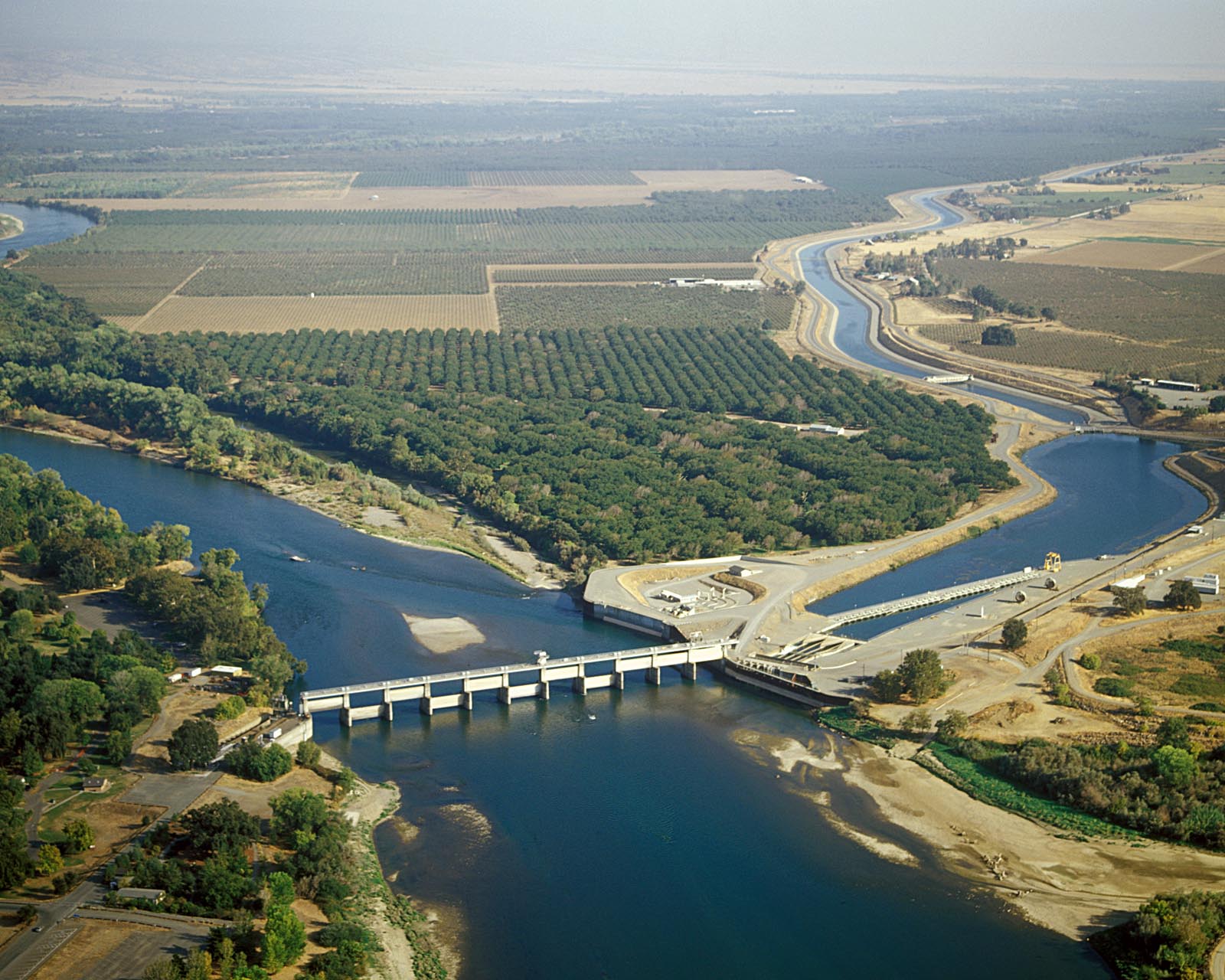
Below Shasta Dam the Sacramento River enters the foothills region of the northern Sacramento Valley. It flows through Keswick Dam, where it receives about 1200000 acre.ft of water per year diverted from the Trinity River. It then swings east through Redding, the largest city of the Shasta Cascade region, and turns southeast, entering Tehama County. East of Cottonwood it receives Cottonwood Creek – the largest undammed tributary – from the west, then Battle Creek a short distance downstream. Below Battle Creek it carves its last gorge, Iron Canyon, emerging from the hills at Red Bluff, where a pumping station (which replaced the Red Bluff Diversion Dam) removes water for irrigation. Beyond Red Bluff the river reaches the low floodplain of the Sacramento Valley, receiving Mill Creek from the east and Thomes Creek from the west near Los Molinos, then Deer Creek from the east near Vina.

Southeast of Corning, the Sacramento forms the boundary of Tehama County to the west and Butte County to the east. A few miles downstream it forms the border of Butte County and Glenn County to the west. Stony Creek joins from the west in Glenn County, near Hamilton City and about 15 mi west of Chico. The river then forms the Glenn–Colusa County line for a short distance before crossing entirely into Colusa County. It passes by the Sutter Buttes, a group of volcanic hills that rise abruptly from the middle of the Sacramento Valley, where it receives Butte Creek from the east at Colusa. Below Colusa the river flows south-southeast, forming the border of Colusa County and Sutter County to the east.
About 20 mi further downstream, the Sacramento River reaches the Tisdale Weir. During floods, water overtops the weir and flows east into the Sutter Bypass, the first of two major bypass channels that temporarily store and move floodwaters downstream to reduce pressure on the main channel of the Sacramento. The Sacramento River and the Sutter Bypass flow parallel for over 40 mi, rejoining on the border of Sutter County and Yolo County near Knights Landing. The Feather River, the largest tributary of the Sacramento, joins from the east at Verona directly below the Sutter Bypass. A second flood control structure, the Fremont Weir, diverts flood waters from both the Sacramento and Feather Rivers into the Yolo Bypass, which parallels the Sacramento River down the west side of the valley. Cache Creek and Putah Creek, two major tributaries which formerly joined the Sacramento River from the west, are now intercepted by the Yolo Bypass via man-made channels. The main channel of the Sacramento flows south, forming the Yolo–Sacramento County line.
Lower river
As the river continues south it approaches the Sacramento metro area, the largest population center in the watershed. Sacramento International Airport is located on the east bank of the river near Fremont. Near downtown Sacramento it receives the American River from the east, then passes under the historic Tower Bridge and Interstate 80 Business. The California State Capitol sits less than 0.5 mi east of the river where the Tower Bridge crosses it. Shortly downstream, the Port of Sacramento is located on the west side of the Sacramento, connected to the river by a lock. The Sacramento River Deep Water Ship Channel provides access to the port from the Pacific, bypassing about 42 mi of the winding lower Sacramento. The channel runs parallel to the Sacramento several miles to the west, and also forms the eastern boundary of the Yolo Bypass. The manually operated Sacramento Weir, located across from downtown Sacramento on the west side of the river, serves to relieve floodwater pressure from the American River by allowing it to drain west into the Yolo Bypass instead of continuing down the Sacramento River.

Downstream of Sacramento, the river enters the Sacramento–San Joaquin River Delta, a vast tidal estuary and inverted river delta of over 1000 mi2 which receives the entire run-off of the Central Valley, a region covering a third of California. The Sacramento is by far the largest contributor of fresh water to the Delta; in an average year, it accounts for more than 80 percent of the fresh water inflow. At Walnut Grove, the manmade Delta Cross Channel connects the Sacramento to the Mokelumne River channel, allowing a portion of the water to be pumped south toward Clifton Court Forebay, the receiving reservoir for the main CVP and State Water Project aqueducts which irrigate millions of acres and supply water to over 23 million people in the San Joaquin Valley, the San Francisco Bay Area and Greater Los Angeles. Although river levels are tidally influenced here and occasionally as far north as Verona, the water stays fresh in all but the driest years. Saltwater intrusion from the Pacific Ocean was one of the main reasons for the construction of the federal Central Valley Project (CVP), whose dams maintain a minimum flow in the Sacramento River to keep seawater at bay.
Below Rio Vista, the lower Sacramento River is rejoined by the Deep Water Ship Channel and the Yolo Bypass and curves southwest along the base of the Montezuma Hills, forming the border of Solano and Sacramento Counties. This part of the river is dredged for navigation by large oceangoing vessels and averages three-quarters of a mile (1.2 km) across. North of Antioch and Pittsburg, the Sacramento and San Joaquin Rivers join at the head of Suisun Bay, marking the official end of both rivers. The combined waters flow west through Suisun Bay and the Carquinez Strait into San Pablo Bay and San Francisco Bay, joining the Pacific at the Golden Gate.
Discharge
Following the Columbia River, the Sacramento is the largest river by discharge on the Pacific coast of the continental United States. The natural runoff of the river is 22 e6acre.ft per year, or about 30000 cuft/s. Before dams were built on its tributaries, the river flooded up to 650000 cuft/s during the rainy season, equal to the flow of the Mississippi River. Late summers of particularly dry years could see flows drop below 1000 cuft/s.{{cite web |access-date = August 28, 2010 |url-status = dead |archive-url = https://web.archive.org/web/20090813040059/http://ca.water.usgs.gov/sac_nawqa/study_description.html |archive-date = August 13, 2009
The U.S. Geological Survey (USGS) has stream gauges on 25 locations along the Sacramento River, although not all of them are currently operational.{{cite web |access-date = September 20, 2010 |url-status = dead |archive-url = https://web.archive.org/web/20160303174148/http://waterdata.usgs.gov/nwis/annual?referred_module=sw&search_station_nm=sacramento%20river&search_station_nm_match_type=beginning&state_cd=ca&format=station_list&sort_key=site_no&group_key=NONE&list_of_search_criteria=state_cd,search_station_nm,realtime_parameter_selection |archive-date = March 3, 2016 |access-date = February 19, 2016 |url-status = dead |archive-url = https://web.archive.org/web/20160311134238/http://wdr.water.usgs.gov/wy2013/pdfs/11447650.2013.pdf |archive-date = March 11, 2016 |access-date = February 19, 2016
Although the Sacramento River nominally begins near Mount Shasta, the true hydrological source of the Sacramento River system is the Pit River, which is by far the largest of the three rivers flowing into Shasta Lake. At the USGS Montgomery Creek gauge, the average flow of the Pit River was 4760 cuft/s for the period 1966–2013.{{cite web |access-date = February 19, 2016 |url-status = dead |archive-url = https://web.archive.org/web/20160311134206/http://wdr.water.usgs.gov/wy2013/pdfs/11365000.2013.pdf |archive-date = March 11, 2016 |access-date = February 19, 2016 |url-status = dead |archive-url = https://web.archive.org/web/20160311133651/http://wdr.water.usgs.gov/wy2013/pdfs/11342000.2013.pdf |archive-date = March 11, 2016 |access-date = February 19, 2016 |url-status = dead |archive-url = https://web.archive.org/web/20160311132133/http://wdr.water.usgs.gov/wy2013/pdfs/11368000.2013.pdf |archive-date = March 11, 2016
Monthly combined discharge of Sacramento River at Freeport and Yolo Bypass near Woodland (cfs) Colors= id:lightgrey value:gray(0.8) id:darkgrey value:gray(0.3) id:sfondo value:rgb(1,1,1) id:barra value:rgb(0.6,0.8,0.9)
ImageSize = width:650 height:300 PlotArea = left:60 bottom:60 top:30 right:30 DateFormat = x.y Period = from:0 till:55000 TimeAxis = orientation:vertical AlignBars = justify ScaleMajor = gridcolor:lightgrey increment:20000 start:0 ScaleMinor = gridcolor:lightgrey increment:10000 start:0 BackgroundColors = canvas:sfondo
BarData= bar:Jan text:Jan. bar:Fév text:Feb. bar:Mar text:Mar. bar:Avr text:Apr. bar:Mai text:May bar:Jun text:Jun. bar:Jul text:Jul. bar:Aoû text:Aug. bar:Sep text:Sep. bar:Oct text:Oct. bar:Nov text:Nov. bar:Déc text:Dec.
PlotData= color:barra width:30 align:left
bar:Jan from:0 till: 50800 bar:Fév from:0 till: 54200 bar:Mar from:0 till: 45620 bar:Avr from:0 till: 35260 bar:Mai from:0 till: 24500 bar:Jun from:0 till: 18470 bar:Jul from:0 till: 15720 bar:Aoû from:0 till: 14920 bar:Sep from:0 till: 14850 bar:Oct from:0 till: 12630 bar:Nov from:0 till: 16130 bar:Déc from:0 till: 32700
PlotData= bar:Jan at: 50800 fontsize:S text: 50,800 shift:(-12,5) bar:Fév at: 54200 fontsize:S text: 54,200 shift:(-12,5) bar:Mar at: 45620 fontsize:S text: 45,620 shift:(-12,5) bar:Avr at: 35260 fontsize:S text: 35,260 shift:(-12,5) bar:Mai at: 24500 fontsize:S text: 24,500 shift:(-12,5) bar:Jun at: 18470 fontsize:S text: 18,470 shift:(-12,5) bar:Jul at: 15720 fontsize:S text: 15,720 shift:(-12,5) bar:Aoû at: 14920 fontsize:S text: 14,920 shift:(-12,5) bar:Sep at: 14850 fontsize:S text: 14,850 shift:(-12,5) bar:Oct at: 12630 fontsize:S text: 12,630 shift:(-12,5) bar:Nov at: 16130 fontsize:S text: 16,130 shift:(-12,5) bar:Déc at: 32700 fontsize:S text: 32,700 shift:(-12,5)
Watershed

The Sacramento River's watershed is the largest entirely in California, covering much of the northern part of the state. The endorheic (closed) Goose Lake drainage basin in southern Oregon, however, has been known to overflow into the Sacramento River system during particularly wet years. The Sacramento River basin generally lies between the Sierra Nevada and Cascade Range on the east and the Coast Ranges and Klamath Mountains in the west, although the part of the basin drained by the Pit River extends east of the Cascades.{{cite map |access-date = August 29, 2010 |url-status = dead |archive-url = https://web.archive.org/web/20110725052626/http://www.sacriver.org/images/srw_map_poster.gif |archive-date = July 25, 2011 |access-date = August 31, 2010 |url-status = dead |archive-url = https://web.archive.org/web/20100531204215/http://ca.water.usgs.gov/sac_nawqa/enviroset.html |archive-date = May 31, 2010
By discharge, it is the second-largest contiguous U.S. river draining into the Pacific, after only the Columbia River, which has almost ten times the flow of the Sacramento. The Colorado River, which reaches the Gulf of California just south of the US-Mexico border near the southeast part of the state, is far larger than the Sacramento in terms of length and drainage area but has a slightly smaller flow. The Sacramento, when combined with the Pit, is also one of the longest rivers in the United States entirely within one state—after Alaska's Kuskokwim and Texas' Trinity.
The major drainage basins bordering that of the Sacramento are that of the Klamath in the north, the San Joaquin and Mokelumne to the south and the Eel River in the west. The Russian River also lies to the west and the endorheic (closed) Honey Lake and Eagle Lake basins to the north. On the east side are many endorheic watersheds of the Great Basin including the Truckee River and Carson River. Parts of the Sacramento watershed come very close to, but do not extend past, the border of California and Nevada.{{cite web |access-date = February 21, 2017 |url-status = dead |archive-url = https://web.archive.org/web/20170222053339/https://www3.epa.gov/region9/water/watershed/measurew/feather-sac/index.html |archive-date = February 22, 2017 |access-date = August 31, 2010 |url-status = live |archive-url = https://web.archive.org/web/20100527084939/http://nhdgeo.usgs.gov/viewer.htm |archive-date = May 27, 2010
Physiography
The basin's diverse geography ranges from the glacier-carved, snowcapped peaks of the Sierra Nevada to the sea-level (and often lower) marshes and farmlands of the Sacramento-San Joaquin Delta. The highest point is 14104 ft at Mount Shasta, a dormant stratovolcano near the headwaters of the Sacramento River.{{cite gnis |access-date=August 31, 2010}} The Sierra Nevada peaks generally decrease in height from south to north—from over 10000 ft in the headwaters of the American River near Lake Tahoe, to 5000 to in Lassen County where they adjoin the Cascade Range. On the west side, the Coast Ranges are the opposite, increasing in height to almost 10000 ft in the north. The arid volcanic plateaus in the northeast, which are characterized by alternating hills and large sedimentary basins, typically lie at elevations of 3000 to.
Most of the Sacramento Valley is below 300 ft in elevation; in its lower course, the Sacramento River drops only about 1 ft per mile.{{cite web |access-date = August 31, 2010 |url-status = dead |archive-url = https://web.archive.org/web/20100718104206/http://www.ucmp.berkeley.edu/science/profiles/erwin_0609geology.php |archive-date = July 18, 2010
Further south, much of the delta region is actually below sea level: subsidence caused by wind erosion and intensive farming have caused the land in the delta to gradually sink since the late 19th century. Many of the delta islands would be underwater if not for the maintenance of the levees and pumps that keep them dry. Some of the "islands" are now up to 25 ft below the adjacent channels and sloughs.{{cite web |access-date = August 31, 2010 |url-status = live |archive-url = https://web.archive.org/web/20100910224619/http://ca.water.usgs.gov/archive/reports/fs00500/fs00500.pdf |archive-date = September 10, 2010
Land use
The Sacramento River watershed is home to about 2.8 million people; more than two-thirds live within the Sacramento metropolitan area. Other important cities are Chico, Redding, Davis and Woodland. The Sacramento River watershed covers all or most of Shasta, Tehama, Glenn, Butte, Plumas, Yuba, Sutter, Lake and Yolo Counties. It also extends into portions of Siskiyou, Modoc, Lassen, Lake (in Oregon), Sierra, Nevada, Placer, El Dorado, Sacramento, Solano and Contra Costa Counties. The river itself flows through Siskiyou, Shasta, Tehama, Butte, Glenn, Colusa, Sutter, Yolo, Sacramento, Solano and Contra Costa, often forming boundaries between the counties.
Many of the mountainous regions of the watershed are administered by the U.S. Forest Service. The Sacramento River watershed includes large areas of coniferous forests in the Mendocino and Trinity National Forests in the Coast Ranges, Shasta and Lassen National Forests in the southern Cascades and the Plumas, Tahoe and Eldorado National Forests on the western slopes of the Sierra Nevada. The watershed also has Lassen Volcanic National Park, which covers 106000 acre centered on Lassen Peak, the southernmost Cascade volcano.{{cite web |access-date = September 5, 2010 |url-status = dead |archive-url = https://web.archive.org/web/20100527135530/http://vulcan.wr.usgs.gov/Volcanoes/Lassen/Locale/framework.html |archive-date = May 27, 2010
Geology

By geologic standards, the Sacramento is a fairly young river; the borders of its watershed began to form only a few million years ago as magma welling up below the Earth's crust pushed up by the Pacific Plate colliding with the North American Plate caused the formation of the Sierra Nevada. Although mountains had existed as early as 100 million years ago in this region (before then the land was probably submerged under the Pacific), they were worn by erosion, and the present-day range only formed about 4 million years ago.{{cite web |access-date=August 29, 2010 |url-status=dead |archive-url=https://web.archive.org/web/20100817124438/http://www.sierrahistorical.org/archives/geology.html |archive-date=August 17, 2010 |access-date = August 29, 2010 |url-status = dead |archive-url = https://web.archive.org/web/20100626202157/http://geog.ucsb.edu/~joel/g148_f09/readings/cascades/cascades.html |archive-date = June 26, 2010
As the Sierra rose, water erosion and glaciation carved deep canyons, depositing massive amounts of sediment to form a coastal plain between the mountains and the Pacific Ocean. About 3 million years ago, multiple terranes were formed and smashed into the North American Plate from the Pacific Plate, causing the uplift of the California Coast Ranges, enclosing the Sacramento Valley and forcing the streams within to flow south instead of west, forming the ancestral Sacramento River. (The Klamath Mountains, which enclose the northwest part of the Sacramento Basin, were formed in the same way but are much older, dating back 7.5 million years.) It is possible that the river once had its outlet in Monterey Bay, and may have played a part in the formation of the 300 mi Monterey Submarine Canyon when sea levels were lower during the Ice Ages.{{cite web |access-date = August 29, 2010 |url-status = dead |archive-url = https://web.archive.org/web/20100528000929/http://www.nature.nps.gov/geology/inventory/publications/s_summaries/WHIS_scoping_summary_20041025.pdf |archive-date = May 28, 2010 |access-date = August 29, 2010 |url-status = dead |archive-url = https://web.archive.org/web/20100106112149/http://www.sanctuarymonitoring.org/monterey/sections/submarineCanyons/overview.php?sec=sc |archive-date = January 6, 2010
The Monterey Bay outlet of the Sacramento and San Joaquin rivers was blocked off by uplift about 2 million years ago, and runoff from the Sierra began to transform the Central Valley into a gigantic lake, called Lake Clyde. This lake stretched 500 mi north to south and was at least 1000 ft deep. About 650,000 years ago the lake catastrophically overflowed, draining into San Francisco Bay and creating the Carquinez Strait, the only major break for hundreds of miles in the Coast Ranges.{{cite web |access-date = August 29, 2010 |url-status = dead |archive-url = https://web.archive.org/web/20101014153202/http://www.nationalatlas.gov/articles/geology/features/centralvalley.html |archive-date = October 14, 2010 |access-date = August 29, 2010 |url-status = dead |archive-url = https://web.archive.org/web/20100618204806/http://www.swhydro.arizona.edu/archive/V5_N2/feature3.pdf |archive-date = June 18, 2010
History
Native Americans
The Sacramento River and its valley were one of the major Native American population centers of California. The river's abundant flow and the valley's fertile soil and mild climate provided enough resources for hundreds of groups to share the land. Most of the villages were small. Although it was once commonly believed that the original natives lived as tribes, they actually lived as bands, family groups as small as twenty to thirty people.{{cite web |access-date = August 8, 2010 |url-status = dead |archive-url = https://web.archive.org/web/20110224082200/http://www.parks.ca.gov/pages/485/files/sutter%20and%20the%20native%20peoples.pdf |archive-date = February 24, 2011 |access-date = August 8, 2010 |url-status = dead |archive-url = https://web.archive.org/web/20100929171852/http://sacramentohistory.org/resources_essay.html |archive-date = September 29, 2010 |archive-url = https://web.archive.org/web/20060427064000/http://www.sanmanuel-nsn.gov/images/sm_CA-NA-map-big.gif |url-status = dead |archive-date = April 27, 2006 |access-date = August 8, 2010 |access-date = August 8, 2010 |url-status = dead |archive-url = https://web.archive.org/web/20100710163720/http://www4.hmc.edu:8001/humanities/indian/california/tribemap.gif |archive-date = July 10, 2010
Most of the Sacramento Valley's native peoples relied on hunting, gathering and fishing, although agriculture was practiced in a few areas. Settlement size ranged from small camps to villages of 30–50 permanent structures.{{cite web |access-date = August 25, 2010 |url-status = dead |archive-url = https://web.archive.org/web/20090213203606/http://www.nps.gov/history/history/online_books/5views/5views1h90.htm |archive-date = February 13, 2009 They also hunted waterfowl, antelope and deer which all existed in huge numbers in the rich valley bottom and marsh lands. Before European contact, the indigenous population of the Sacramento Valley has been estimated at 76,000 people.
European exploration and settlement
.jpg)
The first outsiders to see the river were probably the members of a Spanish colonial-exploratory venture to Northern California in 1772, led by Captain Pedro Fages. The group ascended a mountain, likely in the hills north of Suisun Bay, and found themselves looking down at the delta of the Sacramento and San Joaquin Rivers. However, due to their vantage point, neither Fages nor any of his men saw the Sacramento clearly. They assumed that the San Joaquin, coming from the south, was the largest of the merging rivers they saw. In 1808, explorer Gabriel Moraga, on a journey to find suitable sites for the construction of missions, became the first foreigner to see the river clearly. Judging its huge breadth and power he named it Rio de los Sacramentos, or "River of the Blessed Sacrament". In the following years, two more Spanish expeditions traversed the lower part of the river, the last one in 1817.{{cite web |access-date = August 25, 2010 |url-status = live |archive-url = https://web.archive.org/web/20101229061853/http://www.hmdb.org/marker.asp?MarkerID=25880&Print=1 |archive-date = December 29, 2010
The next visitors were Hudson's Bay Company (HBC) fur trappers exploring southwards from the disputed Oregon Country, starting in the 1820s. The first organized expedition, led by Peter Skene Ogden, arrived in the area of Mount Shasta in 1826.{{cite web |access-date = August 25, 2010 |url-status = dead |archive-url = https://web.archive.org/web/20110727102145/http://www.museumsiskiyoutrail.org/upper_soda_springs_information/hunters_and_trappers.html |archive-date = July 27, 2011
Gold Rush
Although just one of thousands of American emigrants that poured into California over the next few years when California became part of the United States, John Augustus Sutter's arrival marked a turning point in the history of the Sacramento Valley, and California as a whole. In 1841, Sutter and his men built a fortress at the confluence of the Sacramento and American Rivers and the Mexican government granted him almost 50000 acre of land surrounding the two rivers. Naming it New Helvetia, he created an agricultural empire in the lower Sacramento Valley, attracting several hundred settlers to the area, and relied on Native American labor to maintain his domain. Sutter had something of a two-faced relationship with the many Native American groups in the area. He was friendly with some of the tribes, and paid their leaders handsomely for supplying workers, but others he seized by force to labor in the fields.{{cite web |access-date = August 25, 2010 |url-status = dead |archive-url = https://web.archive.org/web/20100330122128/http://www.pbs.org/weta/thewest/people/s_z/sutter.htm |archive-date = March 30, 2010 |access-date = August 25, 2010 |url-status = live |archive-url = https://web.archive.org/web/20100826061311/http://www.parks.ca.gov/?page_id=485 |archive-date = August 26, 2010
_01.jpeg)
After the Bear Flag Revolt of 1846 and the Mexican–American War, in which California became part of the United States, Sutter and other large landholders in California held on to their properties. In 1848 Sutter assigned James W. Marshall to build a sawmill on the South Fork American River at Coloma, where Marshall discovered gold.{{cite web |access-date = August 26, 2010 |url-status = live |archive-url = https://web.archive.org/web/20110612002058/http://www.historynet.com/james-marshall-californias-gold-discoverer.htm |archive-date = June 12, 2011 |access-date = August 26, 2010 |url-status = dead |archive-url = https://web.archive.org/web/20110213050344/http://www.newsinhistory.com/blog/president-james-polk%E2%80%99s-speech-spurs-california-gold-rush |archive-date = February 13, 2011 |access-date = August 26, 2010 |url-status = live |archive-url = https://web.archive.org/web/20100604015408/http://articles.sfgate.com/2010-05-23/news/20910589_1_chronicle-exclusive-paper |archive-date = June 4, 2010 As the miners expanded their diggings deeper into the Sierra Nevada and Klamath Mountains, Native Americans were pushed off their land and a long series of skirmishes and fights began that continued until intervention by the state and national governments.{{cite web |access-date = August 26, 2010 |url-status = dead |archive-url = https://web.archive.org/web/20110305210202/http://www.cfses.org/salmonid/html/people/cali.htm |archive-date = March 5, 2011
Post-Gold Rush development and effects
The influx of migrants brought foreign diseases like malaria and smallpox, which American Indians had no immunity to. These diseases killed off a large proportion of their population within a few decades of the arrival of Sutter and the following settlers,{{cite book |last = Cook |access-date = April 16, 2014 |access-date = August 26, 2010 |url-status = dead |archive-url = https://web.archive.org/web/20110718102453/http://mendonews.wordpress.com/2008/03/11/feather-river-indians-sentenced-to-trail-of-death-the-chico-to-covelo-forced-march-of-1863/ |archive-date = July 18, 2011 |access-date=August 26, 2010 |url-status=dead |archive-url=https://web.archive.org/web/20101112001702/http://www.maidu.com/ourhistory/ethno-history.html |archive-date=November 12, 2010
As mining developed from simple methods such as panning and sluicing to a new form of commercialized extraction, hydraulic mining, profits from the petering gold rush made a second leap, earning more profits than placer miners in the early years had ever made.{{cite web |access-date = August 27, 2010 |url-status = dead |archive-url = https://archive.today/20120904015048/http://www.ncgold.com/History/BecomingCA_Archive26.html |archive-date = September 4, 2012 |access-date = August 27, 2010 |url-status = dead |archive-url = https://web.archive.org/web/20100819063811/http://capitolmuseum.ca.gov/uploadedFiles/Capitol_Museum/Teachers/statecaps.pdf |archive-date = August 19, 2010
It was not long after Sacramento surpassed a population of 10,000, then the Great Flood of 1862 swept away much of it (and almost everything else along the Sacramento River) and put the rest under water. The flood waters were exacerbated by the sediments washed down by the millions of tons by hydraulic mining, which filled the beds of the Sacramento, Feather and American rivers up to 7 ft in Sacramento and also covered thousands of acres of Central Valley lands.{{cite web |access-date=August 27, 2010 |url-status=dead |archive-url=https://web.archive.org/web/20101030024957/https://learncalifornia.org/doc.asp?id=526 |archive-date=October 30, 2010 |access-date = August 27, 2010 |url-status = dead |archive-url = https://web.archive.org/web/20101226020223/http://www.redlandsfortnightly.org/papers/Taylor06.htm |archive-date = December 26, 2010 |access-date = August 27, 2010 |url-status = dead |archive-url = https://web.archive.org/web/20100620064914/http://museumca.org/goldrush/fever19-hy.html |archive-date = June 20, 2010
Repeated floods and increased demand for Sacramento River water saw a plethora of massive changes to the environment beginning in the 20th century. An early project was undertaken to raise the entire city of Sacramento about 11 ft above its original elevation.{{cite web |access-date = August 27, 2010 |url-status = dead |archive-url = https://web.archive.org/web/20110722075611/http://www.sacramentopress.com/headline/28148/The_lowdown_on_Sacramentos_underground |archive-date = July 22, 2011 |access-date = September 8, 2010 |url-status = dead |archive-url = https://web.archive.org/web/20031204190045/http://www.safca.org/floodRisk/index.html |archive-date = December 4, 2003
Dams and water use
.jpg)
From the late 19th century through the 20th century, California experienced an economic boom that led to the rapid expansion of both agriculture and urban areas. The Central Valley was becoming a heavily developed irrigation farming region, and cities along the state's Pacific coast and the Sacramento and San Joaquin rivers were growing rapidly, requiring river control to prevent flooding on the one hand, and to ensure a consistent supply of water on the other. The U.S. Army Corps of Engineers and the State of California completed reports as early as the 1870s and 1880s which outlined future development of the Sacramento, Feather, Yuba and Bear rivers.{{cite web |access-date = August 27, 2010 |url-status = dead |archive-url = https://web.archive.org/web/20100823082851/http://www.water.ca.gov/swp/history.cfm |archive-date = August 23, 2010
In 1873, Colonel B.S. Alexander of the Army Corps of Engineers surveyed the Central Valley's hydrology and irrigation systems and proposed a great network of pumps and canals that would take water from the Sacramento River in the north, and transport it to drought-prone central and southern California, especially the San Joaquin Valley. The Sacramento River basin receives "two-thirds to three-quarters of northern California's precipitation though it has only one-third to one-quarter of the land. The San Joaquin River watershed occupies two-thirds to three-quarters of northern California's land, but only collects one-third to one-quarter of the precipitation."{{cite web |access-date = August 27, 2010 |url-status = dead |archive-url = https://web.archive.org/web/20100527101033/http://www.usbr.gov/history/cvpintro.html |archive-date = May 27, 2010
Sacramento River Flood Control Project
.jpg)
The Sacramento River Flood Control Project was authorized by the federal government in 1917. While it intended to contain minor floods in the river banks by strengthening the existing levee system, the main feature was a series of bypasses, or sections of the valley intentionally designed to flood during high water. Weirs placed at strategic points along the Sacramento River release water into the bypasses when the river reaches a certain stage, relieving the pressure of floodwaters on the main channel. The bypasses are then allowed to drain slowly once flood crests have passed. For most of the year, the bypasses remain dry and are used for annual crops such as rice. Some of the principal features are the Butte Basin, Colusa Basin, Sutter Bypass and the Yolo Bypass. The Butte Basin is a large lowland area on the east side of the river between Hamilton City and Colusa; the geographically similar Colusa Basin is located to the west. The Sutter Bypass begins at Colusa and runs parallel to the east side of the Sacramento River until reaching the confluence with the Feather River. The Yolo Bypass, located on the west side of the river, starts at the confluence of the Feather and rejoins the Sacramento in the Delta. Although termed "bypasses", the system essentially reconnects the Sacramento with a portion of its historic flood plain, which it would have naturally flooded had the levee system not been in place.
Central Valley Project

Main article: Central Valley Project
During the Great Depression in the 1930s, the first concrete proposals for a statewide water engineering project emerged, but when the state government could not sell the necessary bonds to fund the project, the federal government took over. The Central Valley Project, one of the largest irrigation projects in the world, was constructed by the U.S. Bureau of Reclamation beginning in 1935.{{cite web |access-date = August 27, 2010 |url-status = dead |archive-url = https://web.archive.org/web/20100901110747/http://www.usbr.gov/mp/cvp/index.html |archive-date = September 1, 2010 |access-date = August 27, 2010 |url-status = dead |archive-url = https://web.archive.org/web/20110707214457/http://bayariel.com/PDF/ARO-ShastaDam.pdf |archive-date = July 7, 2011 |access-date = August 27, 2010 |url-status = dead |archive-url = https://web.archive.org/web/20110614221715/http://www.usbr.gov/projects/Project.jsp?proj_Name=Shasta%2FTrinity%20River%20Division%20Project |archive-date = June 14, 2011 |access-date = August 27, 2010 |url-status = dead |archive-url = https://web.archive.org/web/20111112095147/http://www.usbr.gov/projects/Project.jsp?proj_Name=Sacramento%20Canals%20Unit%20Project |archive-date = November 12, 2011
State Water Project
Main article: California State Water Project
In 1960, construction began on the State Water Project, whose primary purpose was to deliver water to Los Angeles and the San Francisco Bay Area. Oroville Dam – the tallest dam in the U.S. – was built on the Sacramento's largest tributary, the Feather River. A series of channels were enlarged in the Delta to facilitate water flow from the Sacramento to the Banks Pumping Plant and the California Aqueduct, which can carry as much as 4.2 e6acre.ft of water each year.{{cite encyclopedia |access-date = August 28, 2010 |access-date = August 28, 2010 |url-status = dead |archive-url = https://web.archive.org/web/20100901034636/http://www.water.ca.gov/swp/swptoday.cfm |archive-date = September 1, 2010
Over the years, several other plans materialized to divert rivers from California's North Coast into the Sacramento watershed, as future demand was projected to exceed supply. The only one to be built was the Trinity River Project (which would become part of the CVP), sending over 90 percent of the flow of that river into the Sacramento via a tunnel under the Klamath Mountains.{{cite web |access-date = August 29, 2010 |url-status = dead |archive-url = https://web.archive.org/web/20110517182828/http://www.fotr.org/tdhistory.html |archive-date = May 17, 2011 |access-date=August 29, 2010 |url-status=dead |archive-url=https://web.archive.org/web/20100615221008/http://water.washington.edu/Outreach/Publications/WatershedReview/watershedreviewv3n2.pdf |archive-date=June 15, 2010 |access-date = August 29, 2010 |url-status = dead |archive-url = https://web.archive.org/web/20110718100838/http://humboldtherald.wordpress.com/2009/05/23/undoing-of-the-dos-rios-dam/ |archive-date = July 18, 2011 |access-date = August 29, 2010 |url-status = dead |archive-url = https://web.archive.org/web/20101230103124/http://www.calwatchdog.com/2010/03/04/dam-plan-shrouded-in-mystery/ |archive-date = December 30, 2010
Navigation
The Sacramento River Deep Water Ship Channel was completed in 1963, and was built to facilitate navigation of large oceangoing ships from the Delta to the port of Sacramento. The channel bypasses the winding lower part of the Sacramento River between the state capital and the Delta thus reducing water travel times. It also serves to discharge floodwaters from the lower end of the Yolo Bypass. Built by the Army Corps of Engineers, the canal is 43 mi long and is maintained to a depth of 30 ft.{{cite web |access-date=August 28, 2010 |url-status=dead |archive-url=https://web.archive.org/web/20110722185923/http://www.spd.usace.army.mil/projectfacts/ca/civ/SacramentoRiverDeepWaterShipChannel/factsheet/735_9341.htm |archive-date=July 22, 2011
Ecology and environmental issues
The Sacramento River and its drainage basin once supported extensive riparian habitat and marshes, in both the Sacramento Valley and the Delta, home to a diverse array of flora and fauna. Due to the reclamation of land for agriculture and the regulation of seasonal flooding, the amount of water-based habitat declined greatly during the 20th century. Other human impacts include the heavy water consumption for agriculture and urban areas, and pollution caused by pesticides, nitrates, mine tailings, acid mine drainage and urban runoff. The Sacramento supports 40–60 species of fish,{{cite web |access-date = August 29, 2010 |url-status = dead |archive-url = https://web.archive.org/web/20100328011044/http://www.sacramentoriverportal.org/fish/index.htm |archive-date = March 28, 2010 |access-date=August 29, 2010 |url-status=dead |archive-url=https://web.archive.org/web/20111005204135/http://www.feow.org/ecoregion_details.php?eco=125 |archive-date=October 5, 2011 |access-date = August 29, 2010 |url-status = dead |archive-url = https://web.archive.org/web/20110727231046/http://www.sacramentoriverportal.org/birds/index.htm |archive-date = July 27, 2011
Located along the Pacific Flyway, the sprawling wetlands of the Sacramento Valley are an important stop for migratory birds; however, only a fraction of the historic wetlands remain.{{cite web |access-date = August 29, 2010 |url-status = dead |archive-url = https://web.archive.org/web/20110727231046/http://www.sacramentoriverportal.org/birds/index.htm |archive-date = July 27, 2011
There were once 9 species of amphibians that used the Sacramento River,{{cite web |access-date = August 29, 2010 |url-status = dead |archive-url = https://web.archive.org/web/20110727231120/http://www.sacramentoriverportal.org/amphibians/index.htm |archive-date = July 27, 2011 |access-date = August 29, 2010 |url-status = dead |archive-url = https://web.archive.org/web/20100119181830/http://www.sacramentoriverportal.org/reports/beehive/apdx8.pdf |archive-date = January 19, 2010
Riparian and wetlands areas along the Sacramento once totaled more than 500000 acre; today only about 10000 acre remains. Much of this consists of restored stretches and artificially constructed wetlands. Levee construction has prevented the river from changing course during winter and spring floods, which was crucial to the renewal of existing wetlands and the creation of new ones. Since the late 19th century the river has been mostly locked in a fixed channel, which once could shift hundreds of feet or even several miles in a year because of floods. In 2010, about 100 mi of the river's riparian forests were undergoing restoration.
UC Davis initiated a project known as The Nigiri Project which takes place under the Yolo Bypass in the rice field floodplains adjacent to the Sacramento River. The name comes from a form of Japanese sushi which contains a slice of fish on top of a compressed wedge of vinegared rice. Salmon migrate from the Central Valley rivers to the ocean where they increase in size for one to three years then return to rivers to spawn, if a young fish is larger when they enter the ocean, they will have more of a chance to return for spawning. According to UC Davis Center for Watershed Sciences these rice fields adjacent to the Sacramento River will serve as potential nurseries for salmon. UC Davis also concluded from past experimental releases of salmon, that the Yolo Bypass floodway could have up to 57,000 acres of a productive breeding habitat with almost no cost to farmers. The Nigiri project has demonstrated off-season agriculture fields such as the rice fields under the Yolo Bypass next to Sacramento River can serve as an important floodplain habitat and feeding ground for juvenile or endangered fish. UC Davis noted juveniles grew much bigger and faster within the flooded rice fields when compared to those released in the Sacramento River. Public agencies, conservation groups and landowners have all been working together and conducting experiments since 2011. Experiments conducted on rice fields took place at the Knaggs Ranch property within the Yolo Bypass by Sacramento River for four consecutive winters. UC Davis shares their results produced the fastest growth of juvenile Chinook salmon in the Central Valley to ever be recorded. The Nigiri project attempted to see if these floodplains as surrogate wetlands which can be controlled to copy the Sacramento River system's annual natural flooding cycle the native fish depend on. Runoff water from agriculture is used to flood the fields for most of this experiment adjacent to the Sacramento River. The water is eventually flushed back into the Delta ecosystem through agricultural canals.
Anadromous fish
|access-date = 2010-08-29 |url-status = dead |archive-url = https://web.archive.org/web/20110622013730/http://www.ens-newswire.com/ens/apr2008/2008-04-10-092.html |archive-date = 2011-06-22
Second only to the Columbia River on the west coast of the United States in Chinook salmon runs, the Sacramento and its tributaries once supported a huge population of this fish. Millions of salmon once swam upstream to spawn in the Sacramento; as recently as 2002 eight hundred thousand fish were observed to return to the river.{{cite web |access-date = August 29, 2010 |display-authors = etal |url-status = dead |archive-url = https://web.archive.org/web/20110721060136/http://www.swr.noaa.gov/media/SalmonDeclineReport.pdf |archive-date = July 21, 2011 |access-date = August 31, 2010 |url-status = live |archive-url = https://web.archive.org/web/20110319223424/http://www.scientificamerican.com/article.cfm?id=earth-talks-salmon |archive-date = March 19, 2011
Starting in the 20th century, dam construction blocked off hundreds of miles of salmon-spawning streams, such as the upper Feather and American Rivers, and the entirety of the Pit and upper Sacramento rivers. Pollution from farms and urban areas took a heavy toll on the river's environment, and heavy irrigation withdrawals sometimes resulted in massive fish kills. Since 1960, when the big pumps at the head of the California Aqueduct in the Delta began their operation, the pattern of water flow in the Delta has been changed considerably leaving the fish confused as to where to go, resulting in many generations dying off because they have not been able to find their way upstream. In 2004, only 200,000 fish were reported to return to the Sacramento; in 2008, a disastrous low of 39,000.{{cite news |access-date = August 29, 2010 |url-status = dead |archive-url = https://web.archive.org/web/20110928031624/http://yubanet.com/regional/Poor-Ocean-and-River-Conditions-Spurred-Sacramento-Salmon-Collapse.php |archive-date = September 28, 2011
In 1999, five hydroelectric dams on Battle Creek, a major tributary of the Sacramento River, were removed to allow better passage of the fish. Three other dams along the creek were fitted with fish ladders. The river is considered one of the best salmon habitats in the watershed because of its relatively cold water and the availability of ideal habitat such as gravel bars.{{cite news |access-date=September 6, 2010}}{{cite web |access-date = September 6, 2010 |url-status = dead |archive-url = https://web.archive.org/web/20020619074125/http://www.outsideonline.com/magazine/0299/9902dam.html |archive-date = June 19, 2002
By the late 20th and early 21st centuries, the government blamed crashing fish populations on overfishing, especially off the Northern California and Oregon coast, which lie directly adjacent to the migration paths of Sacramento River salmon. This has resulted in a ban on coastal salmon fishing for several years since 2002.{{cite news |access-date = August 29, 2010 |url-status = live |archive-url = https://web.archive.org/web/20100821082046/http://articles.latimes.com/2010/feb/13/local/la-me-salmon13-2010feb13 |archive-date = August 21, 2010 |access-date = August 29, 2010 |url-status = live |archive-url = https://web.archive.org/web/20100906012953/http://www.science.calwater.ca.gov/pdf/eco_restor_winter_chinook.pdf |archive-date = September 6, 2010 |access-date = September 6, 2010 |url-status = live |archive-url = https://web.archive.org/web/20100914101342/http://www.oregonlive.com/environment/index.ssf/2010/02/forecast_is_for_slight_improve.html |archive-date = September 14, 2010
In 1995, a gate on the Folsom Dam on the American River broke open, causing the river's flow to rise by some 40000 cuft/s. The water traveled down the Sacramento and washed into the Pacific; the influx of fresh water was such that it confused thousands of anadromous fish to begin migrating up the river, thinking that the river had risen because of late-autumn storms.{{cite web |access-date = August 29, 2010 |url-status = live |archive-url = https://web.archive.org/web/20111126075103/http://www.pbs.org/wgbh/buildingbig/wonder/structure/folsom.html |archive-date = November 26, 2011
Whales

|Delta the Whale in the Sacramento River]] Whales are occasionally found far inland after navigating the river for food or refuge and then losing track of how to get back to the Pacific Ocean. In October 1985 a humpback whale affectionately named "Humphrey the humpbacked whale" by television media traveled 69 mi up the Sacramento River before being rescued. Rescuers downstream broadcast sounds of humpback whales feeding to draw the whale back to the ocean.
On May 14, 2007, onlookers and media spotted two humpback whales traveling the deep waters near Rio Vista. The duo, generally believed to be mother and calf (Delta, the mother and Dawn, her calf), continued to swim upstream to the deep water ship channel near West Sacramento, about 90 mi inland. There was concern because the whales had been injured, perhaps by a boat's propeller or keel, leaving a gash in each whale's skin. The whales were carefully inspected by biologists and injected with antibiotics to help prevent infection. After days of efforts to lure (or frighten) the whales in the direction of the ocean, the whales eventually made their way south into San Francisco Bay, where they lingered for several days.{{cite news |access-date = March 1, 2009 |url-status = live |archive-url = https://web.archive.org/web/20090515124436/http://www.sfgate.com/cgi-bin/article.cgi?f=%2Fc%2Fa%2F2007%2F05%2F20%2FBAGHFPUJU83.DTL |archive-date = May 15, 2009 |archive-url = https://archive.today/20130128185607/http://origin.mercurynews.com/news/ci_6026633 |url-status = dead |archive-date = January 28, 2013 |access-date = June 2, 2007 |access-date = January 2, 2008 |url-status = live |archive-url = https://web.archive.org/web/20080312092143/http://www.sfgate.com/cgi-bin/article.cgi?f=%2Fc%2Fa%2F2007%2F05%2F31%2FBAGHHQ4ENF1.DTL |archive-date = March 12, 2008
Sea lions
Recently, sea lions have been found traveling far up the Sacramento in search of nutrient rich salmon. These individuals tend to be young males looking to bulk up before breeding season. The recent boom of sea lion sightings in the river has been attributed to the passage of the Marine Mammal Protection Act in 1972, leading to a resurgence in sea lion populations, requiring the species to expand its range.
Common locations to spot sea lions are underneath the Tower Bridge, the mouth of the Feather River, and the confluence of the Sacramento and American River at Discovery Park.
Pollution
.jpg)
For a river of its size, the Sacramento is considered to have fairly clean water. However, pollutants still flow into the river from many of its tributaries and man-made drains or channels. Pesticide runoff, especially DDT, is one of the largest problems faced today, because of the valley's primarily agricultural economy. Increased erosion caused by the removal of riparian vegetation and the runoff of fertilizers into the river have led to occasional algae blooms, though the water is usually cold because of the regulation of dams upstream. Other pollutant sources include urban runoff, mercury and even rocket fuel that was reported to have leaked near the American River from an Aerojet extraction project.{{cite web |access-date = August 31, 2010 |url-status = live |archive-url = https://web.archive.org/web/20081015204129/http://pubs.usgs.gov/circ/circ1215/major_findings.htm |archive-date = October 15, 2008 |access-date=August 31, 2010}}{{cite web |access-date = August 31, 2010 |url-status = dead |archive-url = https://web.archive.org/web/20110616111959/http://cfpub.epa.gov/ncer_abstracts/index.cfm/fuseaction/display.abstractDetail/abstract/5965/report/2000 |archive-date = June 16, 2011
Mercury pollution created by mining and processing activities during the California Gold Rush still has a profound impact on the Sacramento River's environment. According to Domagalski of the USGS, Mercury is currently considered the most serious water-quality problem in the Sacramento River. Mercury is unique because it is the heaviest liquid in existence, it is the only heavy metal that is a liquid at room temperature and it readily vaporizes into the atmosphere. The toxic substance was widely used by miners to separate gold from the surrounding rocks and dirt, and was disposed of by allowing it to evaporate. Most of the mercury was mined in the Coast Ranges to the west of the Sacramento River; mines in these mountains produced roughly 140,000 tons of mercury to serve the Gold Rush. When the gold rush ended, most of the mines were closed but toxic acidic water and chemicals continue to leak from within, into west-side Sacramento tributaries such as Cache Creek and Putah Creek. According to the Sacramento Watershed River Program, an abandoned mercury mine, which is currently an EPA superfund site, is located in the Cache Creek area in the Sacramento River, called the Sulfur Bank Mercury Mine, which is still releasing mercury with leachate into Clear Lake which is close by. This site along with other former mine sites add to the contamination of Cache Creek which is estimated to be responsible for 50% of mercury taken to the Bay Delta area every year. In the east, mercury that permeated into the ground has contaminated several aquifers that feed rivers such as the Feather, Yuba and American. Even the evaporated mercury posed problems – so much of it was used that significant concentrations still linger in the air in many places. According to Griffin with the Sacramento Water Action Team, Mercury cannot naturally escape or dissipate and will be brought down into the soils and sediment to pollute and react with, in some of these cases methane can be produced from the mercury which will contribute to the greenhouse gases and is another contributing issue with mercury pollution, ecological alteration of the Sacramento River and climate change. Griffin shares, "Mercury and its compounds readily attach to particulate material in soil and sediment. In the presence of living organisms ionic mercury can transform into monomethylmercury and dimethylmercury. When exposed to sunlight the (di)methylmercury is photodegraded to monomethyl mercury, usually near the surface of water, and methane gas is released". According to the USGS 2016, the mercury release leaves a permanent imprint not only in the Sacramento River Watershed but also in peat bogs, snowcapped glaciers and sediments up to hundreds and thousands of miles away. Mercury pollution continues today and will probably continue for decades or centuries into the future.
Another form of pollution the Sacramento River is suffering from is plastic pollution. According to researchers from University of California Berkeley, they recorded over 7 trillion microplastics being deposited in the San Francisco Bay each year with the Sacramento River being a major contributor. They also found microplastics in one fourth of anchovy, striped bass and salmon stomachs in the Bay Area.
In July 1991, a train derailed near Dunsmuir, California alongside the Sacramento River. A tank car split open, spilling about 19,500 gallons of the pesticide metam sodium into the river. The chemical formed a stinking, bubbling, green glob that moved 45 mi down the river, killing everything in its path. More than one million fish were killed, including at least 100,000 rainbow trout, and thousands of other aquatic creatures as well as nearby trees. Next, the green glob entered Shasta Lake, California's largest reservoir. Fortunately, a system of aerating pipes at the bottom of the lake had been set up to dissipate the chemical, reducing it to almost nothing by the 29th, preventing further environmental destruction. The tank car carrying the metam sodium through California was of a type that the National Transportation Safety Board said had "a high incidence of failure" in accidents. Furthermore, the tank car was not labeled, so the train's crew was unaware of the danger posed by the chemical.{{cite web |archive-url = https://web.archive.org/web/20010307175154/http://cantaratrustees.org/reports/1996/96reportdw.html#CantaraSpill |url-status = dead |archive-date = March 7, 2001 |access-date = August 24, 2010 |access-date = August 24, 2010 |url-status = live |archive-url = https://web.archive.org/web/20121026113441/http://articles.latimes.com/1991-07-16/news/mn-2353_1_sacramento-river |archive-date = October 26, 2012

Diazinon was a major pollution problem in the Sacramento River which would originate from agricultural and urban storm water discharges. Diazinon is used for orchards which grow peaches, plums, and almonds to mitigate the number of insects and pests like spider mites and aphids. A wide variety of organizations and groups came together to reduce diazinon concentrations in the Sacramento and Feather River systems. Their collaboration and hard work led to the removal of 79 river miles from the 303(d) list for diazinon impairments in 2010 according to the Environmental Protection Agency.
References
Works cited
- {{cite book
- {{cite book |url-access=registration |access-date=April 16, 2014}}
- {{cite book |access-date=April 16, 2014}}
- {{cite book |access-date=April 16, 2014}}
- {{cite book |access-date=April 16, 2014}}
References
- Benke and Cushing, p. 547
- Discharge figure is a combination of [[U.S. Geological Survey. USGS]] gage 11447650 Sacramento River at Freeport and USGS 11453000 Yolo Bypass near Woodland. Flood flows diverted around the Sacramento area via the Sacramento River Flood Control Project are recorded by the Yolo Bypass gage.
- {{cite gnis
- {{cite gnis
- "Boundary Descriptions and Names of Regions, Subregions, Accounting Units and Cataloging Units". U.S. Geological Survey.
- Angel, Devanie. (December 5, 2002). "The 'reasonable' environmentalist: When John Merz talks about the Sacramento River, people listen". Chico News & Review.
- (June 9, 2005). "Rivers of North America". Elsevier.
- (September 2025). "Archived copy".
- "Sightseeing on Shasta Lake". United States Forest Service.
- "Archived copy".
- Ellis, Tom. "How Much Water Flows Through The Sacramento River During a Flood Event?". Family Water Alliance.
- "Understanding Water Use in California and the Sacramento Valley | Northern California Water Association".
- "The Middle Sacramento River: Human Impacts on Physical and Ecological Processes along a Meandering River". US Forest Service.
- "USGS Gage #11447650 on the Sacramento River at Freeport, CA, Monthly Data 1948-2014". U.S. Geological Survey.
- "USGS Gage #11453000 on Yolo Bypass near Woodland, CA, Monthly Data 1945-2011". U.S. Geological Survey.
- (September 1, 2005). "Introduction to the Sacramento River Basin". U.S. Geological Survey.
- The Columbia River has a flow of {{convert. 265000. cuft/s. m3/s, seven times that of the Sacramento. There are other rivers that come close to the Sacramento's discharge such as the [[Skagit River]], with {{convert. 18000. cuft/s. m3/s, or the Klamath River, with {{convert. 17000. cuft/s. m3/s. The [[Colorado River]], which is heavily drawn from for irrigation and municipal water supply, no longer reaches the sea; even its historic flow of {{convert. 22000. cuft/s. m3/s did not come close to the Sacramento.
- Kelley and Kelly, pp.5–15
- Bakken, Gordon Morris and Kindell, Alexandra. (2006). "Encyclopedia of Immigration and Migration in the American West". SAGE.
- ''Exploring the great rivers of North America'', p. 126
- Harton and McCloud, p.8
- Royce and Wells, p.33
- ''Exploring the great rivers of North America'', p. 129
- Baumgardner, Frank H.. (2005). "Killing for land in early California: Indian blood at Round Valley: founding the Nome Cult Indian Farm". Algora Publishing.
- Harton and McCloud, pp. 26–27
- Harton and McCloud, pp. 27–31
- "SAFCA :: Sacramento Regional Flood Control Agency".
- "Archived copy".
- ''Exploring the great rivers of North America'', p. 130
- (August 2000). "Riparian bird populations of the Sacramento River system: Results from the 1993–1999 field seasons". Sacramento River Portal.
- "Sacramento River". The Nature Conservancy.
- Kerlin, Katherine E.. (February 23, 2016). "Nigiri Project Mixes Salmon and Rice Fields for Fifth Year on Floodplain".
- (June 1992). "Humphrey the Lost Whale: a true story". Heian.
- Adatia, Noor. (29 March 2023). "Sea lions in Sacramento? Here's why these marine animals come so far inland".
- Park, Kathy. (2018-05-23). "Sea lions surge in Sacramento; why they're moving in".
- "The Mercury Problem: California Aspects". Sacramento River Watershed Program.
- Chatterjee, Pratap. (Spring 1998). "The Gold Rush Legacy: Greed, Pollution and Genocide". Earth Island Journal.
- "USGS - NAWQA - Water Quality in the Sacramento River Basin - Major Findings".
- "Mercury – Sacramento River Watershed Program".
- (July 8, 2020). "Pollution in the Sacramento River and Hope for Its Future".
- US EPA, REG 09. (December 12, 2012). "Feather and Sacramento Rivers Watersheds".
This article was imported from Wikipedia and is available under the Creative Commons Attribution-ShareAlike 4.0 License. Content has been adapted to SurfDoc format. Original contributors can be found on the article history page.
Ask Mako anything about Sacramento River — get instant answers, deeper analysis, and related topics.
Research with MakoFree with your Surf account
Create a free account to save articles, ask Mako questions, and organize your research.
Sign up freeThis content may have been generated or modified by AI. CloudSurf Software LLC is not responsible for the accuracy, completeness, or reliability of AI-generated content. Always verify important information from primary sources.
Report