From Surf Wiki (app.surf) — the open knowledge base
Roxas Boulevard
Major street in Metro Manila, Philippines
Major street in Metro Manila, Philippines
| Field | Value | ||||
|---|---|---|---|---|---|
| country | PHL | ||||
| type | N | ||||
| route | 61 | ||||
| marker_image | [[File:AH26 (N120) sign.svg | 75px]] [[File:N61 (Philippines).svg | 75px]] | ||
| name | Roxas Boulevard | ||||
| alternate_name | |||||
| image | Roxas Boulevard traffic (Manila)(2019-02-21).JPG | ||||
| image_notes | The boulevard in 2019 facing south, to the southeast of the US Embassy | ||||
| maint | the Department of Public Works and Highways | ||||
| map | Roxas Boulevard route map.svg | ||||
| map_notes | The route of Roxas Boulevard within Metro Manila. Roxas Boulevard is highlighted in red. | ||||
| length_km | 7.6 | ||||
| established | 1910s | ||||
| restrictions | |||||
| allocation | {{plainlist | ||||
| * {{jct | country | PHL | AH | N120}} in Manila and Pasay | |
| * {{jct | country | PHL | N | 61 | nolink=yes}} in Pasay and Parañaque |
| direction_a | North | ||||
| terminus_a | in Ermita, Manila | ||||
| junction | |||||
| *{{jct | country | PHL | N | 155 | name1=Kalaw Avenue}} |
| *{{jct | country | PHL | N | 156 | name1=United Nations Avenue}} |
| *{{jct | country | PHL | N | 140 | name1=Quirino Avenue}} |
| *{{jct | country | PHL | N | 190 | name1=Gil Puyat Avenue}} |
| *{{jct | country | PHL | AH | N1 | name1=EDSA}} |
| *{{Jct | country | PHL | N | 192 | name1=Andrews Avenue}} |
| direction_b | South | ||||
| terminus_b | in Parañaque | ||||
| cities | Manila, Pasay, and Parañaque |
- [[File:Philippines road sign R3-8.svg|25px]] All trucks
- [[File:Philippines_road_sign_R3-9.svg|25px]] All trucks with trailer
- [[File:Philippines_road_sign_R3-7.svg|25px]] All buses
- R-1
- in Manila and Pasay
- in Pasay and Parañaque
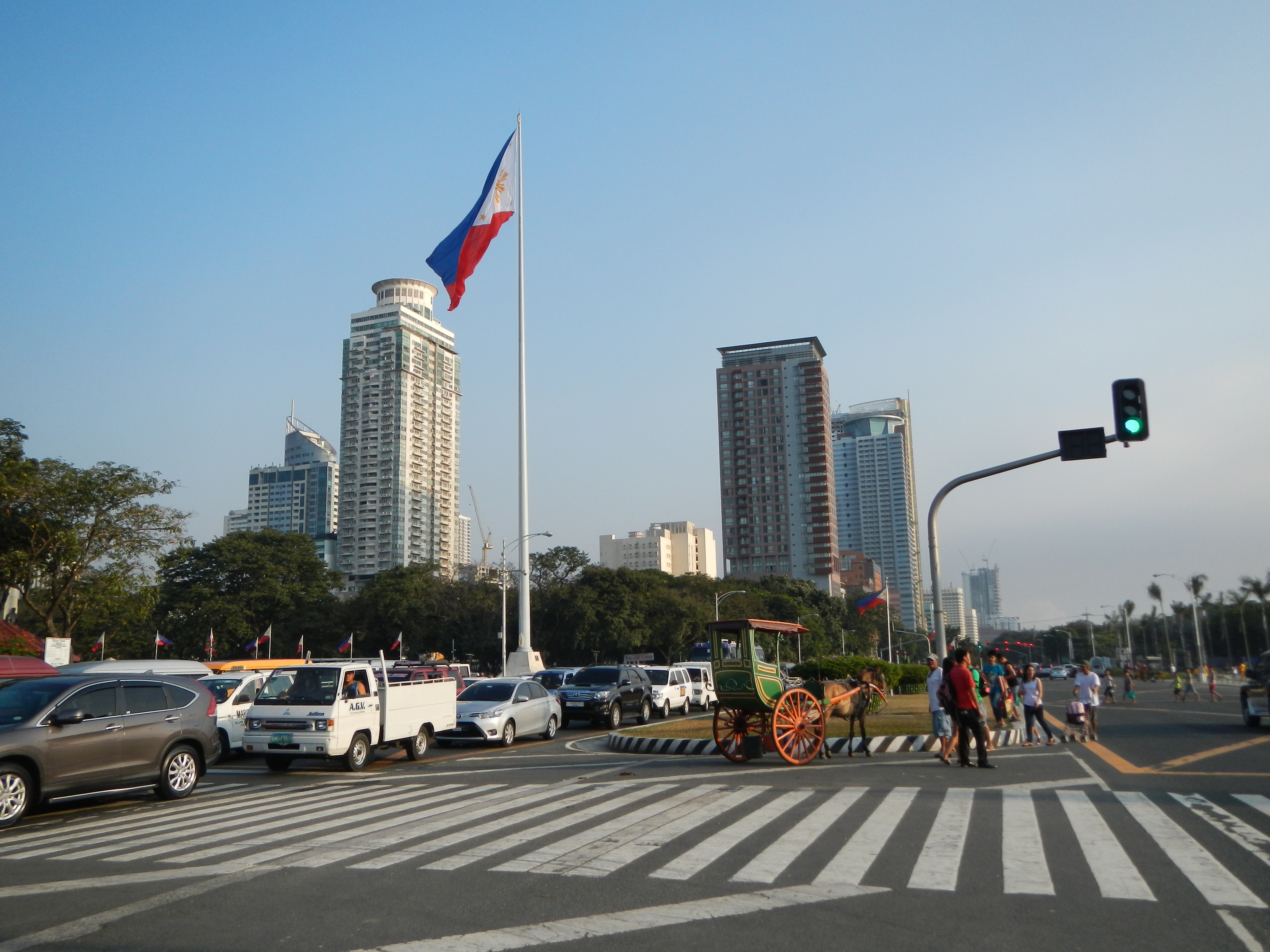
Roxas Boulevard is a popular waterfront promenade in Metro Manila in the Philippines. The boulevard, which runs along the shores of Manila Bay, is well known for its sunsets and stretch of coconut trees. The divided roadway has become a trademark of Philippine tourism, famed for its yacht club, hotels, restaurants, commercial buildings and parks.
The boulevard was completed in the 1910s. Originally called Cavite Boulevard, it was renamed Dewey Boulevard in honor of the American admiral George Dewey, whose forces defeated the Spanish navy in the Battle of Manila Bay in 1898, Heiwa Boulevard in late 1941 during the Japanese occupation, and finally Roxas Boulevard in 1963 in honor of Manuel Roxas, the fifth president of the Philippines. It was also designated as a new alignment of the Manila South Road that connects Manila to the southern provinces of Luzon.
The boulevard is also an eight-lane major arterial road in Metro Manila designated as Radial Road 1 (R-1) of Manila's arterial road network, National Route 61 (N61), the shortest primary route in the Philippines, National Route 120 (N120) of the Philippine highway network and a spur of Asian Highway 26 (AH26). The arcing road runs north–south from Luneta in Manila to Parañaque at the intersection of MIA Road and Seaside Drive of the reclaimed area of Entertainment City beneath the elevated NAIA Expressway. Beyond its southern terminus is the Manila–Cavite Expressway (E3), also formerly known as the Coastal Road, and now more popularly, CAVITEX.
History
City Beautiful movement
Cavite Boulevard was part of Architect Daniel Burnham's plan to beautify the city of Manila. At the request of Commissioner William Cameron Forbes, Burnham visited the country in 1905 at the height of the City Beautiful movement, a trend in the early 1900s in America to make cities beautiful along scientific lines, for the future urban development of Manila and Baguio.
Original concept


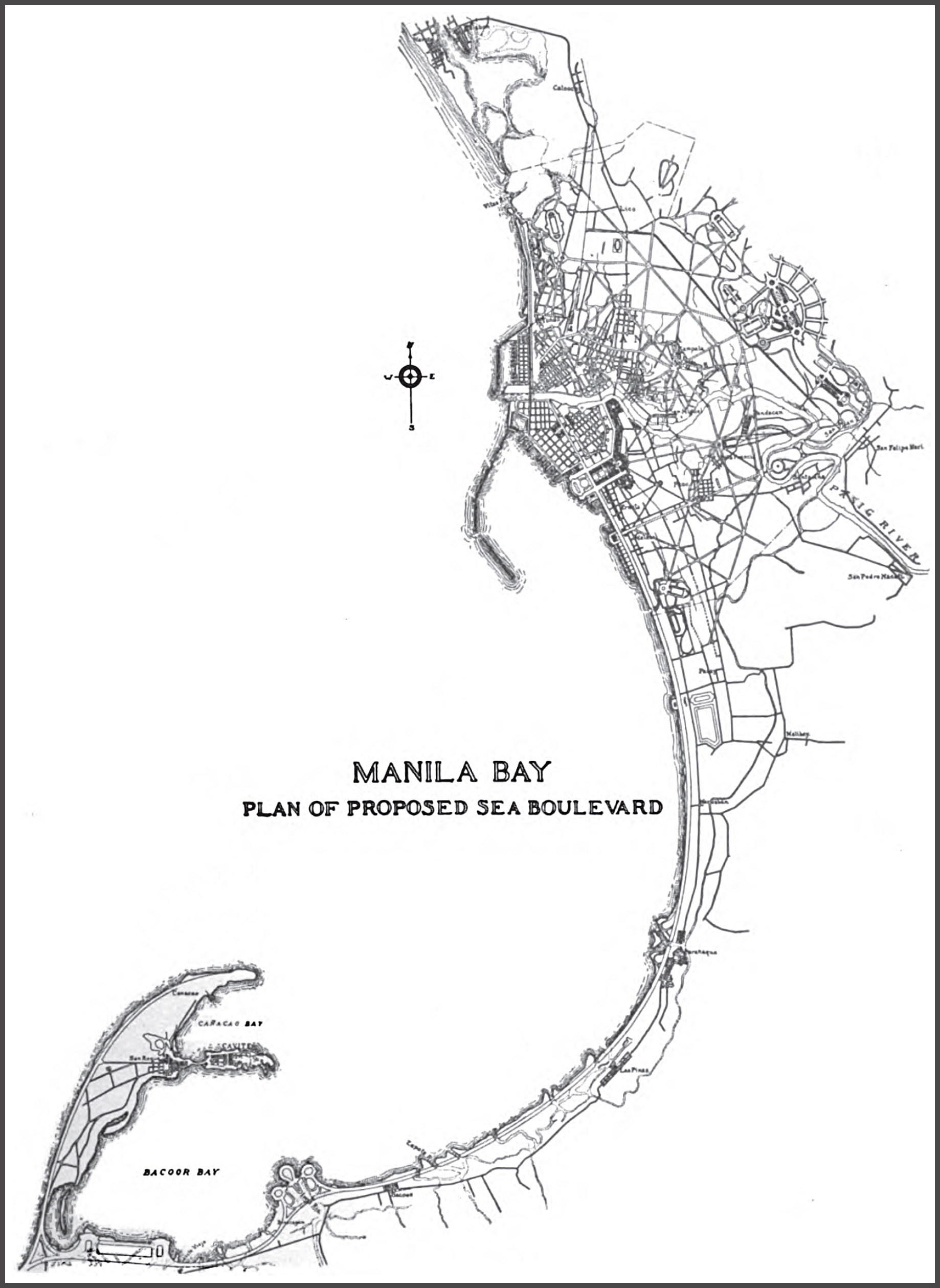
According to Burnham's original concept of the Cavite Boulevard, the bayfront from the Luneta southward should be a continuous parkway, extending with time to the Cavite Navy Yard about 20 mi away. This boulevard, about 250 ft in width, with roadways, tramways, bridle paths, rich plantations, and broad sidewalks, should be available for all classes of people in all sorts of conveyances, and so well-shaded with coconut palms, bamboo, and mangoes as to furnish protection from the elements at all times.
"In order to make the boulevard presentable and useful as soon as possible, a quick-growing tree like the acacia might be planted, alternating with the trees of slower growth, and be replaced after the latter attain their growth. The boulevard's seaward side should be planted so as to interrupt occasionally the view of the sea and, by thus adding somewhat of mystery, enhance the value of the stretch of ocean and sky. The boulevard would be on reclaimed land to about as far south as the old Fort San Antonio Abad in Malate, beyond which it strikes the beach and follows the shoreline to Cavite. The possible extension of the ocean boulevard along the north shore would naturally depend upon the development of the town in that direction and upon the question of additional harbor works north of the Pasig River."
During World War II, the boulevard served as a runway of its namesake airfield. During the 1945 Battle of Manila, however, the Japanese forces cut down palm trees along the boulevard to convert it into an improvised runway.
Contemporary history
During the 1970s, a longstanding debate emerged over the appropriate location for the headquarters of the Association of Southeast Asian Nations (ASEAN). Philippine President Ferdinand Marcos proposed situating the headquarters along Roxas Boulevard in Manila, while Indonesian President Suharto advocated for its placement on Jalan Sisingamangaraja in Jakarta. Consensus at the first was eventually reached in favour of Indonesia as the host country for the ASEAN headquarters.
In 1992, flyovers crossing intersecting roads along the boulevard, such as the Roxas Boulevard–Gil Puyat Flyover and Roxas Boulevard–EDSA Flyover, were opened.
On May 13, 2024, Manila Mayor Honey Lacuña signed Ordinance No. 9047 to make Roxas the boulevard's starting point (Padre Burgos Avenue/Katigbak Parkway) to Quirino Avenue section car-free every early Sunday morning starting May 26, 2024.
Route description
.jpg)
Roxas Boulevard starts at the junction with Katigbak Parkway and Padre Burgos Avenue at Rizal Park in Manila as a continuation of Bonifacio Drive. The road passes through many tall buildings, restaurants, banks, monuments, and other establishments as it curves along Manila Bay. The United States Embassy is located near Rizal Park. A kilometer south are the complex of Bangko Sentral ng Pilipinas (BSP) and Philippine Navy in the Malate district of Manila. After the BSP compound, the boulevard enters Pasay, passing through the Cultural Center of the Philippines (CCP Complex) and Star City. It then intersects with Gil Puyat Avenue and Jose W. Diokno Boulevard, where it ascends through the Gil Puyat Flyover. It then parallels Macapagal Boulevard. It ascends again to intersect Epifanio de los Santos Avenue (EDSA) through the flyover of the same name; there, the route number transitions from N120/AH26, a secondary road, to N61, a primary road. A few meters after passing EDSA, it enters Parañaque, continues into a straight route until it ends on an intersection with MIA Road and Seaside Drive, where the road continues south as the Manila–Cavite Expressway (CAVITEX/E3), which is also known as Coastal Road.
Landmarks
.jpg)

This list is ordered from north to south:
Manila
- Rizal Park
- Kilometer Zero
- Independence Flagpole
- Museo Pambata
- Embassy of the United States in Manila
- Pearl of the Orient Tower
- Grand Riviera Suites
- Plaza Nuestra Señora de Guia (Plaza Ferguson)
- 1322 Golden Empire Tower
- Manila Dolomite Beach
- Baywalk
- Ramon Magsaysay Center
- Plaza Rajah Sulayman
- Malate Church (Our Lady of Remedies Parish)
- The Aristocrat (a nearly hundred year-old Filipino restaurant and bakery+pastry shop)
- Admiral Hotel
- Ospital ng Maynila Medical Center
- Bangko Sentral ng Pilipinas Complex
- BSP Headquarters Building and Museum
- Department of Finance
- Fort San Antonio Abad
- Manila Yacht Club
- Naval Station Jose Andrada (Philippine Navy headquarters)
Pasay
- Cultural Center of the Philippines Complex
- Cultural Center of the Philippines
- Star City
- Department of Foreign Affairs Home Office (under renovation)
- Philippine Trade Training Center
- Cuneta Astrodome
- United States Embassy - Seafront Annex
- US Veterans Affairs Office - Manila Regional Office
- Embassy of Japan in Manila
- Midas Hotel and Casino
- San Juan de Dios Educational Foundation
- Heritage Hotel Manila
- Kanlaon Condominium - original headquarters location of ABS-CBN
Parañaque
- Baclaran Church
- Redemptorist-Aseana station
- City of Dreams Manila
- MIA Road station
- Palacio de Memoria
Intersections

(2017-12-31).jpg)
References
References
- "South Manila". [[Department of Public Works and Highways]].
- "Metro Manila 2nd". [[Department of Public Works and Highways]].
- [http://www.lib.utexas.edu/maps/world_cities/manila.jpg "Manila map"]. University of Texas at Austin Library. Retrieved on June 5, 2011.
- [https://maps.google.com/maps?f=q&source=s_q&hl=en&geocode=&q=Rizal+Park,+Manila,+Philippines&aq=&sll=37.0625,-95.677068&sspn=46.226656,64.072266&ie=UTF8&hq=Rizal+Park,+Manila,+Philippines&ll=14.581777,120.975544&spn=0.013353,0.023839&z=16 "Rizal Park-Manila Map"]. Google Maps. Retrieved on June 5, 2011.
- [https://books.google.com/books?id=KfM3AQAAIAAJ&pg=PA417 "United States Congressional serial set, Issue 5280 - Act no. 1745, Section 2a"], pg. 417. Government Printing Office, Washington.
- (1919). "Map of city of Manila and vicinity". Office of Dept. Engineer, Phil. Dept..
- (1942). "Changing the name of Dewey Boulevard to Heiwa Boulevard; Taft Avenue to Daitoa Avenue; Harrison Boulevard to Koa Boulevard; Jones Bridge to Banzai Bridge; Harrison Park to Rizal Park; and Wallace Field and Burnham Green to Plaza Bagong Filipinas".
- (June 22, 1963). "An Act Changing the Name of Dewey Boulevard, Extending from the City of Manila, Through the City of Pasay, to the Municipality of Parañaque, Province of Rizal, and Any Future Extension Thereof Up to Cavite City, to President Roxas Boulevard".
- (November 6, 1951). "Establishing the Classification of Roads".
- [https://maps.google.com/maps?f=q&source=s_q&hl=en&geocode=&q=Rizal+Park,+Manila,+Philippines&aq=&sll=37.0625,-95.677068&sspn=46.226656,64.072266&ie=UTF8&hq=Rizal+Park,+Manila,+Philippines&ll=14.519884,120.998311&spn=0.013357,0.023839&z=16 "Intersection of Roxas Blvd. and NAIA Rd"]. Google Maps. Retrieved on June 5, 2011.
- (1910). [https://books.google.com/books?id=25sqAAAAYAAJ&pg=PA68 "Report of the Philippine Commission to the Secretary of War"], pg.68. Government Printing Office, Washington.
- (1907-03). [https://books.google.com/books?id=cH1CAQAAIAAJ&pg=PA322 "Far Eastern Review - Details and Description of the Burnham Plans for the Reconstruction of Manila"], pg.322. Google Books. Retrieved on April 13, 2012.
- (July 25, 1944). "Manila and Suburbs, (Japanese Airfields) Philippines".
- "Dewey".
- Cerita, Setiap Gedung Punya. (2019-05-09). "Gedung Sekretariat ASEAN (Sisimangaraja)".
- (2023-05-02). "ASEAN Secretariat Building Reflects the New ASEAN Spirit". AseanAll.
- "Road and Bridge Information Application".
- (May 13, 2024). "Manila to Make Roxas Boulevard Walkable, Bikeable on 'Car-Free Sundays' Starting May 26".
- Mendoza, John Eric. (September 19, 2024). "DFA’s old, historic building to undergo major retrofitting".
This article was imported from Wikipedia and is available under the Creative Commons Attribution-ShareAlike 4.0 License. Content has been adapted to SurfDoc format. Original contributors can be found on the article history page.
Ask Mako anything about Roxas Boulevard — get instant answers, deeper analysis, and related topics.
Research with MakoFree with your Surf account
Create a free account to save articles, ask Mako questions, and organize your research.
Sign up freeThis content may have been generated or modified by AI. CloudSurf Software LLC is not responsible for the accuracy, completeness, or reliability of AI-generated content. Always verify important information from primary sources.
Report