From Surf Wiki (app.surf) — the open knowledge base
Ross County, Ohio
County in Ohio, United States
County in Ohio, United States
| Field | Value |
|---|---|
| county | Ross County |
| state | Ohio |
| flag | Flag of Ross County, Ohio.png |
| seal | Seal of Ross County (Ohio).svg |
| founded | August 20, 1798 |
| seat wl | Chillicothe |
| largest city | Chillicothe |
| area_total_sq_mi | 693.03 |
| area_land_sq_mi | 689.19 |
| area_water_sq_mi | 3.84 |
| area percentage | 0.6% |
| census yr | 2020 |
| pop | 77093 |
| pop_est_as_of | 2021 |
| density_sq_mi | 110 |
| time zone | Eastern |
| web | www.co.ross.oh.us |
| named for | James Ross |
| ex image | Chillicothe ohio ross county courthouse 2006.jpg |
| ex image size | 250 |
| ex image cap | Ross County Courthouse |
| district | 2nd |
Ross County is a county in the Appalachian region of the U.S. state of Ohio. As of the 2020 United States census, the population was 77,093. Its county seat is Chillicothe, the first and third capital of Ohio. Established on August 20, 1798, the county is named for Federalist Senator James Ross of Pennsylvania. Ross County comprises the Chillicothe, OH Micropolitan Statistical Area, which is also included in the Columbus-Marion-Zanesville, OH Combined Statistical Area.
History
Ross County was formed by proclamation of Governor St. Clair, August 20, 1798, being the sixth county formed in the Northwest Territory.
Ross County was described by Ephraim George Squier and Edwin Hamilton Davis as having almost "one hundred enclosures of various sizes, and five hundred mounds" in their book, Ancient Monuments of the Mississippi Valley (1848). They described the Indian-built earthworks as ranging from 5 to(-) in size, and enclosures of 1 to(-) large. These included Serpent Mound, Fort Ancient, Mound City, and Seip Earthworks (both now part of Hopewell Culture National Historical Park), and Newark Earthworks.
Geography
The Scioto River flows southward through the east-central part of the county. Paint Creek drains the lower central part of the county, flowing eastward to its terminus with the Scioto at a point southeast of Chillicothe. The county terrain consists of frequent wooded hills, with the intermediate level areas devoted to agriculture. The county's highest point is Farrell Hill, 6 mi northeast of Bainbridge. The county has a total area of 693 sqmi, of which 689 sqmi is land and 3.8 sqmi (0.6%) is water. Ross County is the second-largest county by land area in Ohio, after Ashtabula County, as well as the fifth-largest by total area.
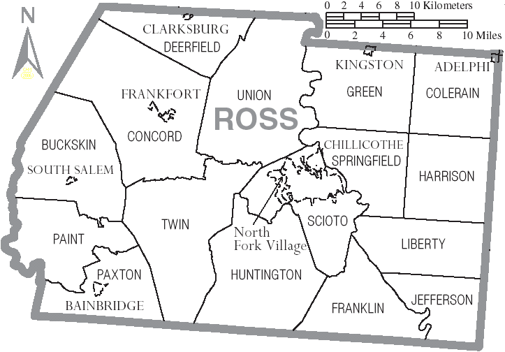
Adjacent counties
- Pickaway County - north
- Hocking County - northeast
- Vinton County - east
- Jackson County - southeast
- Pike County - south
- Highland County - southwest
- Fayette County - northwest
Protected areas
- Adena State Memorial
- Great Seal State Park
- Hopewell Culture National Historical Park
- Paint Creek State Park (part)
- Pleasant Valley Wildlife Area
- Ross Lake Wilderness Area
- Scioto Trail State Forest
- Scioto Trail State Park (part of American Discovery Trail)
- Tar Hollow State Forest (part)
Demographics
|align-fn=center 1790-1960 1900-1990 1990-2000 2020
2020 census
As of the 2020 census, the county had a population of 77,093. The median age was 41.4 years. 21.1% of residents were under the age of 18 and 17.8% of residents were 65 years of age or older. For every 100 females there were 109.3 males, and for every 100 females age 18 and over there were 110.5 males age 18 and over.
The racial makeup of the county was 88.3% White, 5.2% Black or African American, 0.3% American Indian and Alaska Native, 0.5% Asian,
41.2% of residents lived in urban areas, while 58.8% lived in rural areas.
There were 29,386 households in the county, of which 29.2% had children under the age of 18 living in them. Of all households, 46.2% were married-couple households, 18.9% were households with a male householder and no spouse or partner present, and 26.2% were households with a female householder and no spouse or partner present. About 28.2% of all households were made up of individuals and 13.1% had someone living alone who was 65 years of age or older.
There were 32,066 housing units, of which 8.4% were vacant. Among occupied housing units, 69.5% were owner-occupied and 30.5% were renter-occupied. The homeowner vacancy rate was 1.2% and the rental vacancy rate was 6.7%.
Racial and ethnic composition
| Race / Ethnicity (NH = Non-Hispanic) | title=1980 Census of Population - General Social and Economic Characteristics - Ohio- Table 59 - Persons by Spanish Origin, Race, and Sex: 1980 AND Table 58 - Race by Sex: 1980 | url=https://www2.census.gov/library/publications/decennial/1980/volume-1/ohio/1980censusofpopu80137un_bw.pdf | website=United States Census Bureau | pages=49–67 and 27–47}} | Pop 1990 | title=P004: Hispanic or Latino, and Not Hispanic or Latino by Race – 2000: DEC Summary File 1 – Ross County, Ohio | url=https://data.census.gov/table?g=050XX00US39141&tid=DECENNIALSF12000.P004 | website=United States Census Bureau | access-date= }} | title=P2: Hispanic or Latino, and Not Hispanic or Latino by Race – 2010: DEC Redistricting Data (PL 94-171) – Ross County, Ohio | url=https://data.census.gov/cedsci/table?q=p2&g=050XX00US39141&tid=DECENNIALPL2010.P2 | website=United States Census Bureau | access-date= }} | Pop 2020 | % 1980 | % 1990 | % 2000 | % 2010 | % 2020 |
|---|---|---|---|---|---|---|---|---|---|---|---|---|---|---|---|---|---|---|---|
| White alone (NH) | 61,003 | 64,137 | 66,991 | 70,378 | 67,705 | 93.84% | 92.51% | 91.34% | 90.15% | 87.82% | |||||||||
| Black or African American alone (NH) | 3,404 | 4,412 | 4,534 | 4,804 | 4,005 | 5.24% | 6.36% | 6.18% | 6.15% | 5.20% | |||||||||
| Native American or Alaska Native alone (NH) | 63 | 146 | 206 | 212 | 189 | 0.10% | 0.21% | 0.28% | 0.27% | 0.25% | |||||||||
| Asian alone (NH) | 164 | 265 | 258 | 295 | 369 | 0.25% | 0.38% | 0.35% | 0.38% | 0.48% | |||||||||
| Native Hawaiian or Pacific Islander alone (NH) | x | x | 14 | 7 | 20 | x | x | 0.02% | 0.01% | 0.03% | |||||||||
| Other race alone (NH) | 80 | 24 | 78 | 106 | 196 | 0.12% | 0.03% | 0.11% | 0.14% | 0.25% | |||||||||
| Mixed race or Multiracial (NH) | x | x | 835 | 1,514 | 3,578 | x | x | 1.14% | 1.94% | 4.64% | |||||||||
| Hispanic or Latino (any race) | 290 | 346 | 429 | 748 | 1,031 | 0.45% | 0.50% | 0.58% | 0.96% | 1.34% | |||||||||
| Total | 65,004 | 69,330 | 73,345 | 78,064 | 77,093 | 100.00% | 100.00% | 100.00% | 100.00% | 100.00% |
2010 census
As of the 2010 United States census, there were 78,064 people, 28,919 households, and 19,782 families in the county. The population density was 113 /mi2. There were 32,148 housing units at an average density of 46.6 /mi2. The racial makeup of the county was 90.7% white, 6.2% black or African American, 0.4% Asian, 0.3% American Indian, 0.3% from other races, and 2.1% from two or more races. Those of Hispanic or Latino origin made up 1.0% of the population.
Of the 28,919 households, 32.8% had children under the age of 18 living with them, 50.2% were married couples living together, 12.6% had a female householder with no husband present, 31.6% were non-families, and 26.2% of all households were made up of individuals. The average household size was 2.48 and the average family size was 2.95. The median age was 39.8 years.
The median income for a household in the county was $42,626 and the median income for a family was $50,081. Males had a median income of $42,721 versus $32,374 for females. The per capita income for the county was $20,595. About 13.1% of families and 17.3% of the population were below the poverty line, including 24.7% of those under age 18 and 8.2% of those age 65 or over.
2000 census
As of the 2000 United States census, there were 73,345 people, 27,136 households, and 19,185 families in the county. The population density was 106 /mi2. There were 29,461 housing units at an average density of 42.7 /mi2. The racial makeup of the county was 91.74% White, 6.20% Black or African American, 0.31% Native American, 0.35% Asian, 0.02% Pacific Islander, 0.19% from other races, and 1.20% from two or more races. 0.58% of the population were Hispanic or Latino of any race.
There were 27,136 households, out of which 32.70% had children under the age of 18 living with them, 55.20% were married couples living together, 11.10% had a female householder with no husband present, and 29.30% were non-families. 24.90% of all households were made up of individuals, and 10.30% had someone living alone who was 65 years of age or older. The average household size was 2.50 and the average family size was 2.97.
The county population contained 24.00% under the age of 18, 8.60% from 18 to 24, 31.60% from 25 to 44, 23.60% from 45 to 64, and 12.20% who were 65 years of age or older. The median age was 37 years. For every 100 females there were 108.30 males. For every 100 females age 18 and over, there were 109.00 males.
The median income for a household in the county was $37,117, and the median income for a family was $43,241. Males had a median income of $35,892 versus $23,399 for females. The per capita income for the county was $17,569. About 9.10% of families and 12.00% of the population were below the poverty line, including 15.10% of those under age 18 and 10.20% of those age 65 or over.
Government
County officials
County officials are (as of October 2024):
- County Auditor Jeff Lehner
- County Board of Elections
- Traci Henness, Director
- Jessica Ott, Deputy Director
- Beth Neal, Chair
- Eric Rinehart, Member
- Doug Corcoran, Member
- Philip Gray, Member
- Clerk of Courts Jordan Wheeler
- Board of Commissioners
- James "Oody" Lowe
- Jack Everson
- David Glass
- Ross County Court of Common Pleas:
- Judge Michael M. Ater
- Judge Matthew Schmidt
- Probate and Juvenile Court Judge J. Jeffrey Benson
- Magistrate John Di Cesare
- County Coroner Ben Trotter
- County Engineer Charles R. Ortman
- County Prosecutor Jeffrey C. Marks
- County Recorder Anthony “Major” Maughmer
- County Treasurer David Jeffers
- County Sheriff George W. Lavender
Politics
Ross is a generally Republican county in Presidential and Congressional elections, although until recent years, Democratic candidates performed fairly well in the county. The last Democrat to win a majority in the county was Lyndon Johnson in 1964, while Bill Clinton won a plurality in 1996 and Barack Obama came within just 439 votes in 2012.
Ross is part of Ohio's 2nd congressional district, which is represented by Republican David Taylor. |}
Education
School districts
School districts covering portions of Ross County include:
- Adena Local School District
- Chillicothe City School District
- Greenfield Exempted Village School District
- Huntington Local School District
- Logan Elm Local School District
- Miami Trace Local School District
- Paint Valley Local School District
- Southeastern Local School District
- Union-Scioto Local School District
- Waverly City School District
- Zane Trace Local School District
Pickaway-Ross Career & Technology Center
Pickaway-Ross lies in the Northern part of the county. Students from the following affiliated Ross and Pickaway county districts attend the vocational school:
- Adena Local School District (Ross County)
- Chillicothe City School District (Ross County)
- Huntington Local School District (Ross County)
- Paint Valley Local School District (Ross County)
- Southeastern Local School District (Ross County)
- Unioto Local School District (Ross County)
- Zane Trace Local School District (Ross County)
- Circleville City School District (Pickaway County)
- Logan Elm Local School District (Pickaway County)
- Westfall Local School District (Pickaway County)
[[Ohio University – Chillicothe|Ohio University Chillicothe]]
Ohio University established a regional campus in Chillicothe in 1966. The university has over 2,500 students enrolled as of 2010, ranging from traditional-aged students and non-traditional learners.
Communities
City
- Chillicothe (county seat)
Villages
- Adelphi
- Bainbridge
- Clarksburg
- Frankfort
- Kingston
- South Salem
Census-designated places
- Andersonville
- Bourneville
- Massieville
- Richmond Dale or Richmondale
Unincorporated communities
- Alma
- Anderson
- Austin
- Brownsville
- Denver
- Fruitdale
- Greenland
- Hallsville
- Harper
- Higby
- Hopetown
- Humboldt
- Ingham
- Kinnikinnick
- Knockemstiff
- Lattaville
- Lickskillet
- Londonderry
- Lyndon
- Metzger
- Mooresville
- Musselman
- Nipgen
- North Fork Village
- Pleasant Grove
- Pleasant Valley
- Pride
- Renick
- Renick Junction
- Roxabell
- Schooley
- Slate Mills
- Spargursville
- Storms
- Summithill
- Tucson
- Vigo
- Yellowbud
Townships
- Buckskin
- Colerain
- Concord
- Deerfield
- Franklin
- Green
- Harrison
- Huntington
- Jefferson
- Liberty
- Paint
- Paxton
- Scioto
- Springfield
- Twin
- Union
Notable people
- Clyde Beatty (1903–1965) - lion tamer and animal trainer
- Blue Jacket (1743–1810) - Shawnee War Chief
- William Granville Cochran (1844–1932) - Illinois state judge and legislator
- Esther Housh (1840–1898) - social reformer, author, editor
- Donald Ray Pollock (1954) - author
- John Purdue (1802–1876) - founding benefactor of Purdue University
- Frederick Madison Roberts (1879–1952) - great-grandson of Sally Hemings and Thomas Jefferson, first African-American elected to office on the West Coast (elected to California Assembly in 1918), and "dean of the assembly" who helped found the University of California at Los Angeles.
- Tecumseh (1768–1813) - Native American Shawnee Leader
References
References
- "Ross County History". Ross County OH.
- [https://www.census.gov/library/visualizations/interactive/2020-population-and-housing-state-data.html 2020 census]
- "Find a County". National Association of Counties.
- (June 2016). "Ross County data". [[Ohio State University]] Extension Data Center}}{{dead link.
- Howe, Henry. (1888). "Historical Collections of Ohio". C.J. Krehbiel & Co..
- Squier, E.G.. (1848). "Ancient Monuments of the Mississippi Valley". [[Smithsonian Institution]].
- [https://www.google.com/maps/place/Ross+County,+OH/@39.3421899,-83.2073927,11z/data=!3m1!4b1!4m5!3m4!1s0x88470fdf286f6199:0x61e230259a3eb961!8m2!3d39.3584253!4d-82.9931607 Ross County OH - Google Maps (accessed 8 June 2019)]
- [https://www.peakbagger.com/peak.aspx?pid=6542 Farrell Hill (PeakBagger.com, accessed 8 June 2019)]
- (August 22, 2012). "2010 Census Gazetteer Files". US Census Bureau.
- [https://www.stateparks.com/adena_state_memorial_in_ohio.html Adena State Memorial (Ohio State Parks) accessed 8 June 2019]
- [http://parks.ohiodnr.gov/greatseal Great Seal State Park (Ohio Div of Natural Resources) accessed 8 June 2019]
- "US Decennial Census". US Census Bureau.
- "Historical Census Browser". University of Virginia Library.
- (March 27, 1995). "Population of Counties by Decennial Census: 1900 to 1990". US Census Bureau.
- (April 2, 2001). "Census 2000 PHC-T-4. Ranking Tables for Counties: 1990 and 2000". US Census Bureau.
- (2021). "2020 Decennial Census Demographic Profile (DP1)".
- (2021). "2020 Decennial Census Redistricting Data (Public Law 94-171)".
- (2023). "2020 Decennial Census Demographic and Housing Characteristics (DHC)".
- "1980 Census of Population - General Social and Economic Characteristics - Ohio- Table 59 - Persons by Spanish Origin, Race, and Sex: 1980 AND Table 58 - Race by Sex: 1980".
- "1990 Census of Population - General Population Characteristics - Ohio: Table 6 - Race and Hispanic Origin".
- "P004: Hispanic or Latino, and Not Hispanic or Latino by Race – 2000: DEC Summary File 1 – Ross County, Ohio".
- "P2: Hispanic or Latino, and Not Hispanic or Latino by Race – 2010: DEC Redistricting Data (PL 94-171) – Ross County, Ohio".
- "P2: Hispanic or Latino, and Not Hispanic or Latino by Race – 2020: DEC Redistricting Data (PL 94-171) – Ross County, Ohio".
- included in the Asian category in the 1980 Census
- included in the Asian category in the 1990 Census
- not an option in the 1980 Census
- not an option in the 1990 Census
- "Profile of General Population and Housing Characteristics: 2010 Demographic Profile Data". US Census Bureau.
- "Population, Housing Units, Area, and Density: 2010 - County". US Census Bureau.
- "Selected Social Characteristics in the US – 2006-2010 American Community Survey 5-Year Estimates". US Census Bureau.
- "Selected Social Characteristics – 2006-2010 American Community Survey 5-Year Estimates". US Census Bureau.
- "U.S. Census website". US Census Bureau.
- Leip, David. "Atlas of US Presidential Elections".
- (November 5, 2024). "2024 Senate Election (Official Returns)".
- Geography Division. (December 18, 2020). "2020 Census - School District Reference Map: Ross County, OH". [[U.S. Census Bureau]].
- "Profile Fact Sheet".
- [https://www.google.com/maps/place/Brownsville,+Huntington+Township,+OH+45601/@39.2606363,-83.0592139,15z/data=!3m1!4b1!4m5!3m4!1s0x8847056cf1bb4015:0xc0f52a0b7abe25c6!8m2!3d39.2606206!4d-83.0504591 Brownsville, Huntington Twp OH - Google Maps (accessed 8 June 2019)]
- "Ingham – OpenStreetMap".
- [https://www.google.com/maps/place/Lickskillet,+Liberty+Township,+OH+45601/@39.2500822,-82.8183719,15z/data=!3m1!4b1!4m5!3m4!1s0x8847af45f18a840b:0xd367d87d28274c79!8m2!3d39.2500665!4d-82.8096171 Lickskillet, Liberty Twp OH - Google Maps (accessed 8 June 2019)]
- [https://www.google.com/maps/place/Metzger,+Green+Township,+OH+45601/@39.3936902,-82.9644894,15z/data=!3m1!4b1!4m5!3m4!1s0x88470ba960f1af91:0xd8ee61065720ea13!8m2!3d39.3936745!4d-82.9557346 Metzger, Green Twp - Google Maps (accessed 8 June 2019)]
- [https://www.google.com/maps/place/Pleasant+Grove,+Twin+Township,+OH+45601/@39.2286927,-83.140883,15z/data=!3m1!4b1!4m5!3m4!1s0x88471ba4c88a1a7b:0x5ca59b3d63e47616!8m2!3d39.2286769!4d-83.1321282 Pleasant Grove, Twin Twp OH - Google Maps (accessed 8 June 2019)]
- [https://www.google.com/maps/place/Pleasant+Valley,+Union+Township,+OH+45601/@39.3725792,-83.0489371,15z/data=!3m1!4b1!4m5!3m4!1s0x88470dcdeb53c161:0xe12e461bd4e46781!8m2!3d39.3725635!4d-83.0401823 Pleasant Valley, Union Twp OH - Google Maps (accessed 8 June 2019)]
This article was imported from Wikipedia and is available under the Creative Commons Attribution-ShareAlike 4.0 License. Content has been adapted to SurfDoc format. Original contributors can be found on the article history page.
Ask Mako anything about Ross County, Ohio — get instant answers, deeper analysis, and related topics.
Research with MakoFree with your Surf account
Create a free account to save articles, ask Mako questions, and organize your research.
Sign up freeThis content may have been generated or modified by AI. CloudSurf Software LLC is not responsible for the accuracy, completeness, or reliability of AI-generated content. Always verify important information from primary sources.
Report