From Surf Wiki (app.surf) — the open knowledge base
Rock River (Mississippi River tributary)
Tributary of the Mississippi River in the US

Tributary of the Mississippi River in the US
| Field | Value |
|---|---|
| name | Rock River |
| image | |
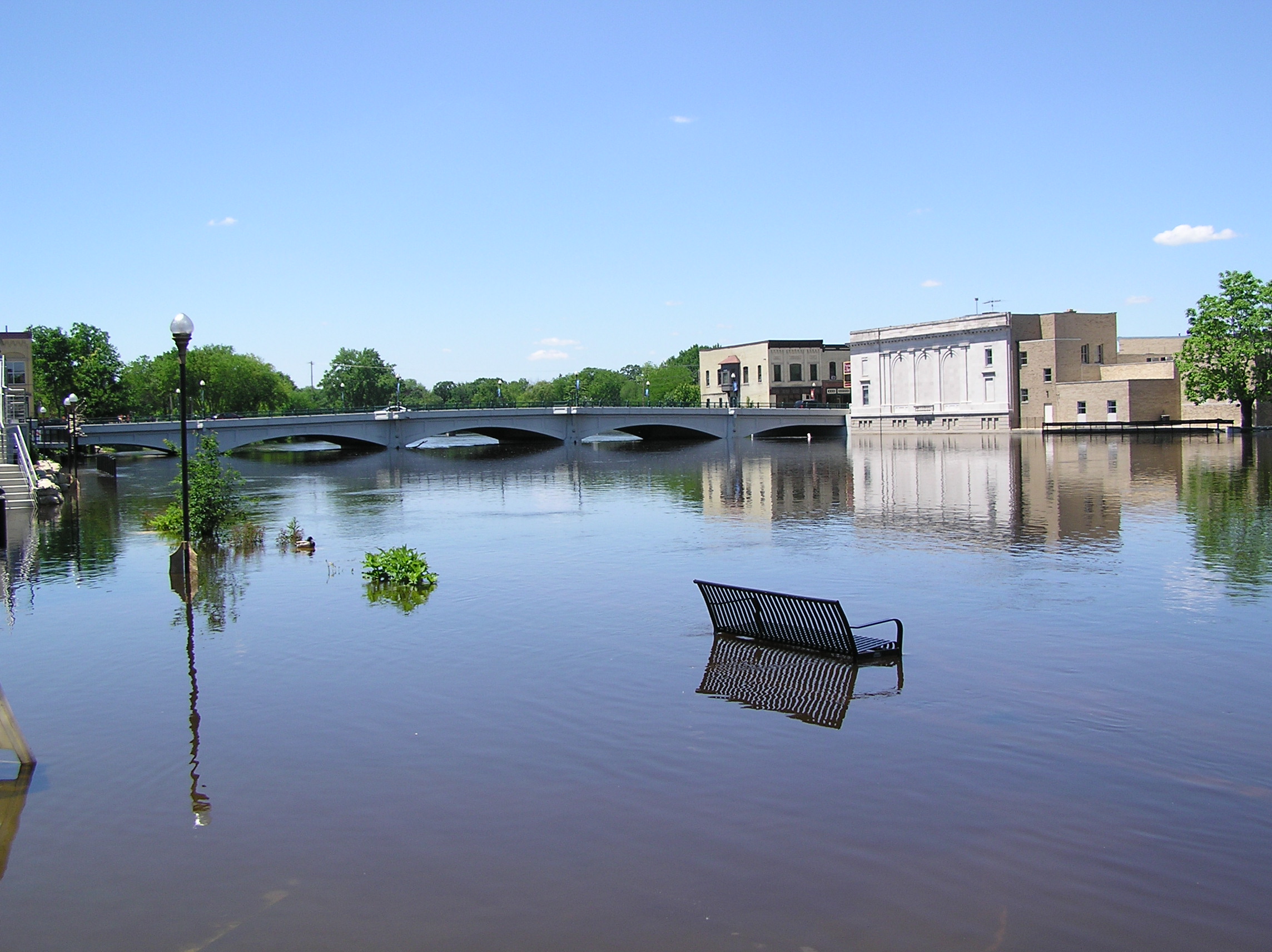
| image_caption | Rock River at Rockford, Illinois |
| image_size | |
| map | Rockilrivermap.png |
| map_caption | Drainage basin of the Rock River |
| subdivision_type1 | Country |
| subdivision_name1 | United States |
| subdivision_type2 | States |
| subdivision_name2 | Wisconsin, Illinois |
| source1_location | Horicon Marsh north of Horicon, Wisconsin |
| source1_coordinates | |
| mouth_location | Confluence with the Mississippi River at Rock Island, Illinois |
| mouth_coordinates | |
| progression | Rock River → Mississippi → Gulf of Mexico |
| mouth_elevation | 551 ft |
| length | 299 mi |
| discharge1_location | Joslin, Illinois |
| discharge1_avg | 7,195 cu/ft. per sec. |
| custom_label | GNIS ID |
| custom_data |
The Rock River is a tributary of the Mississippi River, approximately 299 mi long, in the U.S. states of Wisconsin and Illinois. The river was known as the Sinnissippi to the Sauk and Meskwaki peoples; the name means "rocky waters".
Course
The river, which has a notable higher western bank, begins with three separate branches that flow into the Horicon Marsh. The northernmost branch, the West Branch, begins just to the west of the village of Brandon in Fond du Lac County, Wisconsin and flows east and then south to Horicon Marsh. The South Branch rises north of Fox Lake in Dodge County and flows east through Waupun to the marsh. The East Branch rises southeast of Allenton in Washington County just west of the Niagara Escarpment, and flows north and west through Theresa to the marsh.
Leaving the marsh, it meanders southward to the Illinois border, ending about 300 miles later at the Mississippi River at the Quad Cities in Illinois and Iowa. During its course, it passes through Watertown, collects the Crawfish River in Jefferson, and receives the Bark River at Fort Atkinson. Shortly before merging, the Rock and Crawfish rivers cross Interstate 94. Both rivers flood the nearby land regularly, and lanes on I-94 were temporarily closed in 2008 because of this flooding.
In northern Rock County, Wisconsin, it receives the Yahara River, and flows southward through tiny Fulton, Janesville and Beloit into northern Illinois, where it receives the Pecatonica River 5 miles (8 km) south of the state line. It flows south through Rockford, then southwest across northwestern Illinois, picking up the Kishwaukee River, passing Oregon (here, on a high bluff overlooking the river is the Eternal Indian sculpture), Dixon, Sterling (which has the Sinnissippi Mounds national historic site and local park) and Rock Falls before joining the Mississippi at Rock Island. It was on the Rock River in Dixon where Ronald Reagan was a lifeguard in his youth. Reagan's favorite fishing spot, now called "Dutch Landing" after Reagan's nickname, was just southwest of Lowell Park on the Rock River.
River modifications
There are 24 dams on the Rock River. These are in Theresa (WI, 3 dams), Waupun (WI), Horicon (WI), Mayville (WI, 2 dams), Kekoskee (WI), Hustisford (WI), Watertown (WI, 2 dams), Jefferson (WI, 4 dams), Indianford (WI), Beloit (WI), Rockton (IL), Rockford Fordham (IL), Oregon (IL), Dixon (IL), Sterling / Rock Falls (IL, 2 dams), Milan (IL) and Rock Island (IL).
Recreation
The river is used for various water and paddling sports. The Rock River Water Trail is on the river from its headwaters above the Horicon National Wildlife Refuge in south central Wisconsin to the confluence with the Mississippi River at the Quad Cities of Illinois and Iowa 330 miles downriver. It crosses five counties in Wisconsin, six counties in Illinois and runs through 37 municipalities. The slow moving river passes scenic rural landscapes, wilderness areas and urban areas. The first two trailheads are at Waupun County Park in Waupun, Wisconsin and Rivers Edge Park in Theresa, Wisconsin and there are 32 additional access points in Dodge County, Wisconsin. The trail is part of the National Water Trails System and the first National Water Trail in Wisconsin and Illinois.
Rock River Park is on County Road B about a half mile west of Johnson Creek, Wisconsin in Jefferson County, Wisconsin and offers river access and an artesian spring.

The river is also home to the Rock Aqua Jays, an amateur water ski club that performs at Traxler Park in downtown Janesville, Wisconsin.
Cities and villages along the river
Communities listed from north to south.
- Brandon, Wisconsin (West Branch)
- Waupun, Wisconsin (South Branch)
- Theresa, Wisconsin (East Branch)
- Mayville, Wisconsin (East Branch)
- Kekoskee, Wisconsin (East Branch)
- Horicon, Wisconsin
- Hustisford, Wisconsin
- Ixonia, Wisconsin
- Watertown, Wisconsin
- Johnson Creek, Wisconsin
- Jefferson, Wisconsin
- Fort Atkinson, Wisconsin
- Indianford, Wisconsin
- Fulton, Wisconsin
- Janesville, Wisconsin
- Afton, Wisconsin
- Beloit, Wisconsin
- South Beloit, Illinois
- Rockton, Illinois
- Roscoe, Illinois
- Machesney Park, Illinois
- Loves Park, Illinois
- Rockford, Illinois
- Byron, Illinois
- Oregon, Illinois
- Grand Detour, Illinois
- Dixon, Illinois
- Sterling, Illinois
- Rock Falls, Illinois
- Lyndon, Illinois
- Prophetstown, Illinois
- Erie, Illinois
- Hillsdale, Illinois
- Cleveland, Illinois
- Colona, Illinois
- Moline, Illinois
- Coal Valley, Illinois
- Milan, Illinois
- Rock Island, Illinois
References
References
- "USGS Current Conditions for USGS 05446500 ROCK RIVER NEAR JOSLIN, IL".
- U.S. Geological Survey. National Hydrography Dataset high-resolution flowline data. [http://viewer.nationalmap.gov/viewer/ The National Map], accessed May 13, 2011
- {{gnis. 416824. Rock River
- "Castle Rock State Park". [[Illinois.
- "Upper Rock River basin | Wisconsin DNR".
- Channel 3000. "Interstate 94, Highway 151 Reopen As Water Recedes". Channel 3000.
- City of Dixon. "[http://www.discoverdixon.org/dixon-community/70-reagan-s-roots.html Reagan's Roots]".
- "Dam Information". Rock River Trail.
- "Rock River Dams". PaddleAway.
- "Dodge County, Wisconsin : Rock River Water Trail".
- "Welcome to Jefferson County, Wisconsin".
This article was imported from Wikipedia and is available under the Creative Commons Attribution-ShareAlike 4.0 License. Content has been adapted to SurfDoc format. Original contributors can be found on the article history page.
Ask Mako anything about Rock River (Mississippi River tributary) — get instant answers, deeper analysis, and related topics.
Research with MakoFree with your Surf account
Create a free account to save articles, ask Mako questions, and organize your research.
Sign up freeThis content may have been generated or modified by AI. CloudSurf Software LLC is not responsible for the accuracy, completeness, or reliability of AI-generated content. Always verify important information from primary sources.
Report