From Surf Wiki (app.surf) — the open knowledge base
River Skirfare
River in North Yorkshire, England
River in North Yorkshire, England
| Field | Value |
|---|---|
| name | River Skirfare |
| image | RiverSkirfare.jpg |
| image_caption | River Skirfare |
| source1_location | Confluence of Foxup Beck and Cosh Beck |
| source1_coordinates | |
| mouth_location | River Wharfe |
| mouth_coordinates | |
| subdivision_type1 | Country |
| subdivision_name1 | England |
| length_km | 15.24 |
| source1_elevation | 1,470 ft |
| mouth_elevation | 194 m |
| custom_label | EA waterbody IDs |
| custom_data | |
River Skirfare is a small river in North Yorkshire, England, that flows through Littondale and ends where it joins the larger River Wharfe. The source is the confluence of Foxup Beck and Cosh Beck at the hamlet of Foxup.
The name is of Old Norse origin, from skírr "bright" or "clear" and far "river-course".
Course
The source of the river is the confluence of Foxup Beck and Cosh Beck at the hamlet of Foxup, some 1,470 ft above sea level. To the east bank lays Hawkswick Moor and on the west bank lays Darnbrook Fell, Hawkswick Clowder and Pen-y-ghent Fell. The river meanders consistently south-east for approximately 9.5 mi to the confluence with the River Wharfe.
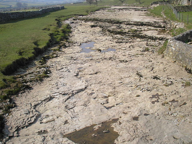
The river drains a catchment area of 52.51 km2. The upper reach of the river above the hamlet of Litton is known to dry up in the summer months with the water flowing underground. It is known that there are huge caverns underneath Littondale where the water sinks, but it reappears south of Arncliffe. Outside of summer, the normal range of the water can be up to 0.58 m, however, the highest level recorded is of 2.79 m, at Skirfare Bridge on 20 February 2022. The water seeping underground is what Marie Hartley and Joan Ingilby state is the reason that saved the valley of Littondale from becoming a huge reservoir. Leeds council considered taking the waters from the river in the 1850s, which they labelled as the "Skirfare Scheme."
Flora and fauna
Trout and bullhead are known to be in the river and its tributaries. Trout use many of the smaller side streams as nurseries for their fry. Signal crayfish are known to have inhabited the Upper Wharfe and the Skirfare riverine system. Imported signal crayfish were kept in a trout farm on the Wharfe in 1983, and it is thought they have got into the river system from there. Historically, the lady's slipper orchid used to grow along the banks of the River Skirfare (examples were noted in the 1930s), however, they now only grow in one site in the Yorkshire Dales.
Literary connections
The valley of Littondale was also previously known as Amerdale, and in his poem The White Doe of Rylstone, Wordsworth refers to the "..deep fork at Amerdale..". In the Water-Babies by Charles Kingsley, Littondale and the Skirfare are referred to as Vendale.
Lists
Tributaries
From the source of the river:
- Halton Gill Beck
- Newshot Gill
- Hesleden Beck
- Potts Beck
- Fosse Beck
- Cowside Beck
- Cote Gill
- Sleets Gill Beck
- Moss Beck
Settlements
From the source of the river:
(valley called Littondale)
- Foxup
- Halton Gill
- Hesleden
- Litton
- Arncliffe
- Arncliffe Cote
- Hawkswick
Crossings
From the source of the river:
- Foxup Bridge
- Halton Gill Bridge
- Unnamed bridge to Nether Hesleden
- Fording point
- New Bridge on farm track
- Footbridge near Litton
- Fording point south of Litton
- Arncliffe Bridge
- Footbridge north of Hawkswick
- Hawkswick Bridge
- Skirfare Bridge on B6160
Gallery
|File:River Skirfare passing through Halton Gill - geograph.org.uk - 132828.jpg|River Skirfare passing through Halton Gill |File:Litton walking sign - geograph.org.uk - 303210.jpg|Litton walking sign on Halton Gill Bridge |File:Ford, River Skirfare - geograph.org.uk - 90906.jpg|Ford, River Skirfare near Litton |File:River erosion near Arncliffe, Littondale, Yorkshire Dales - geograph.org.uk - 40749.jpg|River erosion near Arncliffe, Littondale, Yorkshire Dales |File:Footbridge on Old Gang Lane - geograph.org.uk - 198852.jpg|Footbridge on Old Gang Lane, Hawkswick |File:Skirfare Bridge - geograph.org.uk - 44322.jpg|Skirfare Bridge near confluence with River Wharfe
References
Sources
References
- Smith, A. H.. (1962). "The Place-names of the West Riding of Yorkshire". Cambridge University Press.
- (1979). "Yorkshire Anglers Guide: A Guide to the Whole of the Fishing on the Yorkshire Rivers". Olicana Books.
- "Skirfare from Source to Heselden Beck {{!}} Catchment Data Explorer {{!}} Catchment Data Explorer".
- "Skirfare from Heselden Beck to Cowside Beck {{!}} Catchment Data Explorer {{!}} Catchment Data Explorer".
- "Skirfare from Cowside Beck to River Wharfe {{!}} Catchment Data Explorer {{!}} Catchment Data Explorer".
- "Littondale : Yorkshire Dales National Park".
- (16 June 2023). "Pictures show how river in Yorkshire has dried up as warm weather continues into the weekend". The Yorkshire Post.
- "River Skirfare level at Skirfare Bridge - GOV.UK".
- (19 November 1853). "Leeds Town Council". The Leeds Intelligencer and Yorkshire General Advertiser.
- (2015). "Yorkshire Dales". Collins.
- "Other Orchids of the Dales : Yorkshire Dales National Park".
- (1 May 1951). "The Lady's Slipper". The Times.
- (29 July 1939). "Weekend adventure". Huddersfield Daily Examiner.
- (2015). "Yorkshire Dales". Collins.
- (2006). "The ecology of Cowside Beck : a tributary of the river Skirfare in the Malham area of Yorkshire". Field Studies Council.
- {{NHLE
- {{NHLE
- {{NHLE
- {{NHLE
This article was imported from Wikipedia and is available under the Creative Commons Attribution-ShareAlike 4.0 License. Content has been adapted to SurfDoc format. Original contributors can be found on the article history page.
Ask Mako anything about River Skirfare — get instant answers, deeper analysis, and related topics.
Research with MakoFree with your Surf account
Create a free account to save articles, ask Mako questions, and organize your research.
Sign up freeThis content may have been generated or modified by AI. CloudSurf Software LLC is not responsible for the accuracy, completeness, or reliability of AI-generated content. Always verify important information from primary sources.
Report