From Surf Wiki (app.surf) — the open knowledge base
River Hill, Columbia, Maryland
| Field | Value | |
|---|---|---|
| name | River Hill | |
| native_name | ||
| settlement_type | Village | |
| blank_emblem_type | ||
| dot_x | dot_y = | |
| pushpin_label_position | ||
| pushpin_label | ||
| pushpin_label1 | ||
| coordinates_footnotes | tags -- | |
| subdivision_type | Country | |
| subdivision_name | United States | |
| subdivision_type1 | State | |
| subdivision_name1 | Maryland | |
| subdivision_type2 | City | |
| subdivision_name2 | Clarksville | |
| established_title | Established | |
| established_date | 1990 | |
| established_title1 | ||
| established_title2 | ||
| named_for | River Hill Farm | |
| website |
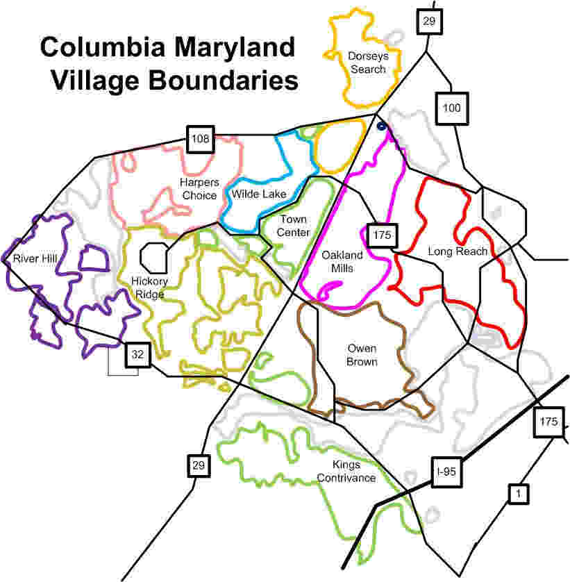
River Hill is the last and westernmost village to be developed in the town of Columbia, Maryland, United States, though some residents maintain addresses in Clarksville. The village is home to 6,520 residents in 2,096 housing units in 2014. The area was used as a game preserve by James Rouse to entertain clients and personal hunting during the buildout of the Columbia project. In 1976, County Executive Edward L. Cochran selected the 784-acre parcel owned by Howard Research and Development for an alternate location for a county landfill; a task force selected Alpha Ridge Landfill instead. Residential construction started in 1990. It is bounded by Maryland Route 108 and Maryland Route 32, and is centered on Trotter Road. The village is divided into two neighborhoods: Pheasant Ridge and Pointers Run, with about 6,500 residents.
The original plan called for the village to be connected to the rest of Columbia via an extension of Little Patuxent Parkway. In addition, a dam on the Middle Patuxent River would have created a large lake in that watershed. However, with the rise of the environmental movement, a large part of the watershed was made into a park, with approximately half of its acreage devoted to open space, which includes the 900 acre of the Middle Patuxent Environmental Area. River Hill is largely disconnected from the rest of the city, accessing Columbia Town Center only by roads on the periphery of the city.
The original plan called for 90 acre to be devoted to apartments, but the rural neighbors wanted a lower population density. The county zoning board decided upon 33 acre for apartments. Consequently, River Hill has the most open space of all the villages.
Etymology
River Hill is named for River Hill Farm, claimed to be one of the first plantations in Maryland to free its slaves, and demolished by the Rouse Company to build Pointer's Run. River Hill consists of the communities of Pheasant Ridge and Pointer's Run. Pheasant Ridge is named after Henry Howard's (1772–1773) 195-acre slave plantation land tract patented on November 16, 1745, later inherited by John Beal Howard.
The street names are derived from the works of Walt Whitman and James Whitcomb Riley.
Education
The Howard County Public School System is a shared public school system serving the village:
- Elementary Schools
- Clarksville Elementary School
- Pointers Run Elementary School
- Middle Schools
- Clarksville Middle School
- High School
- River Hill High School
- Atholton High School
Notable people
- Ken Ulman, Howard County Executive.
References
- Marx, Paul. Jim Rouse:capitalist/idealist (2007), Rowman & Littlefield, , p. 225
Notes
References
- [http://riverhill.columbiavillages.org/ "River Hill Community Association"], riverhill.columbiavillages.org, accessed May 29, 2009
- "River Hill".
- Micheal J. Clark. (8 December 1976). "Howard's first-choice landfill site gets a low rating from task force". The Baltimore Sun.
- Marx, Paul.
- [http://www.columbiavillages.org/index.html "Map"] {{webarchive. link. (2009-08-05 , columbiavillages.org, accessed May 29, 2009)
- (January 5, 1998). "Hunters prepare for managed deer hunt in Howard County". The Gettysburg Times.
- R.H.Melton. (June 30, 1983). "Fugitives From Suburbia Protest Expansion of Columbia". The Washington Post.
- Joseph Rocco Mitchel, David L Stebenne. "New City Upon a Hill".
- "Collection Research: Land Owners & Patents, 1670–1812 ACCESSION NO. A.3.a. iii Property Owners, Land Names, & Acreage – covering Anne Arundel (Howard), Baltimore, Frederick, and Montgomery Counties".
- Joshua Dorsey Warfield. "The founders of Anne Arundel and Howard Counties, Maryland".
- "Pheasant Ridge Records".
- [http://www.hcpss.org "Howard County Public School System"], hcpss.org, accessed May 29, 2009
- Larry Carson. (October 18, 2002). "School-boundary bitterness affects races for council Tensions remain in Columbia's River Hill 'It's very upsetting' Lancos feels impact in effort against Ulman". The Baltimore Sun.
This article was imported from Wikipedia and is available under the Creative Commons Attribution-ShareAlike 4.0 License. Content has been adapted to SurfDoc format. Original contributors can be found on the article history page.
Ask Mako anything about River Hill, Columbia, Maryland — get instant answers, deeper analysis, and related topics.
Research with MakoFree with your Surf account
Create a free account to save articles, ask Mako questions, and organize your research.
Sign up freeThis content may have been generated or modified by AI. CloudSurf Software LLC is not responsible for the accuracy, completeness, or reliability of AI-generated content. Always verify important information from primary sources.
Report