From Surf Wiki (app.surf) — the open knowledge base
River Derwent (Tasmania)
River in south east Tasmania, Australia

River in south east Tasmania, Australia
| Field | Value |
|---|---|
| name | River Derwent |
| name_native | mis (Mouheneenner language) |
| image | Runrise over derwent river.jpg |
| image_size | 280 |
| image_caption | Sunrise over the River Derwent |
| map_size | 280 |
| pushpin_map | Australia Tasmania |
| pushpin_map_size | 280 |
| pushpin_map_caption | Location of the river mouth in Tasmania |
| subdivision_type1 | Country |
| subdivision_name1 | Australia |
| subdivision_type2 | State |
| subdivision_name2 | Tasmania |
| subdivision_type5 | Cities |
| subdivision_name5 | Derwent Bridge, New Norfolk, Hobart |
| length | 239 km |
| discharge1_location | Storm Bay |
| discharge1_min | 50 m3/s |
| discharge1_avg | 90 m3/s |
| discharge1_max | 140 m3/s |
| source1 | Lake St Clair |
| source1_location | Central Highlands |
| source_confluence | |
| source_confluence_location | Cradle Mountain-Lake St Clair National Park |
| source_confluence_coordinates | |
| source_confluence_elevation | 738 m |
| mouth | Storm Bay |
| mouth_location | Hobart |
| mouth_coordinates | |
| mouth_elevation | 0 m |
| basin_size | 9832 km2 |
| tributaries_left | Nive River, Dee River, River Ouse, Clyde River, Jordan River |
| tributaries_right | Repulse River, Tyenna River, Styx River, Plenty River, Lachlan River |
| custom_label | Natural lakes |
| custom_data | Saint Clair Lagoon; Lake St Clair |
| extra |
The River Derwent, also known as timtumili minanya in palawa kani, is a significant river and tidal estuary in Tasmania, Australia. It begins its journey as a freshwater river in the Central Highlands at Lake St Clair, descending over 700 m across a distance of more than 200 km. At the settlement of New Norfolk in the Derwent Valley its waters become brackish, flowing through Hobart, the capital city of Tasmania, its seawater estuary eventually empties into Storm Bay and the Tasman Sea.
Historically, the banks of the Derwent were covered by forests and frequented by Aboriginal Tasmanians. With the arrival of European settlers, the area saw agricultural development and the construction of dams for hydro-electricity generation during the 20th century.
Today, the Derwent's catchment area is characterised by agriculture, forestry, and hydropower generation. It serves as a vital source of water for irrigation and urban supply, notably providing a significant portion of Hobart's water needs. The river is also crucial for recreation, supporting activities such as boating, fishing, and leisure along its banks. Additionally, it facilitates marine transportation and various industrial activities, playing a central role in Tasmania's economy and lifestyle.
Etymology
The upper part of the river was named after the River Derwent, Cumbria by British Commodore John Hayes who explored it in 1793. The name is Brythonic Celtic for "valley thick with oaks".
Matthew Flinders placed the name "Derwent River" on all of the river.
The name "River Derwent" was officially endorsed on 20 May 1959.
History
The River Derwent valley was inhabited by the Muwinina people for at least 8,000 years before British settlement. Evidence of their occupation is found in many middens along the banks of the river. The first European to chart the river was Bruni d'Entrecasteaux, who named it the Rivière du Nord in 1793. Later that same year, John Hayes explored the river and named it after the River Derwent, which runs past his birthplace of Bridekirk, Cumberland.
When first explored by Europeans, the lower parts of the valley were clad in thick she-oak forests, remnants of which remain in various parts of the lower foreshore.
There was a thriving whaling industry until the 1840s when the industry rapidly declined due to over-exploitation.
Geography
Formed by the confluence of the Narcissus and Cuvier rivers within Lake St Clair, the Derwent flows generally southeast over a distance of 187 km to New Norfolk and the estuary portion extends a further 52 km out to the Tasman Sea. Flows average in range from 50 to and the mean annual flow is 90 m3/s.
The large estuary forms the Port of the City of Hobart – the deepest sheltered harbour in the Southern Hemisphere. Some past guests of the port include in February 1836, carrying Charles Darwin; the ; and . The largest vessel to ever travel the Derwent is the 113000 t, 61 m high, ocean liner Diamond Princess, which made her first visit in January 2006.
At points in its lower reaches the river is nearly 3 km wide, and as such is the widest river in Tasmania.
The Derwent estuary contains dozens of white sandy beaches, many of which are staples of local activity within Hobart suburbs and include Bellerive Beach, Blackmans Bay Beach, Howrah Beach, Nutgrove Beach, Lords Beach, Long Beach, Taroona Beach, Hinsby Beach, Kingston Beach and Windermere Beach.
Hydro schemes
Until the construction of several hydro-electric dams between 1934 and 1968, the river was prone to flooding. Now there are more than twenty dams and reservoirs used for the generation of hydro-electricity on the Derwent and its tributaries, including the Clyde, Dee, Jordan, Nive, Ouse, Plenty and Styx rivers. Seven lakes have been formed by damming the Derwent and the Nive rivers for hydroelectric purposes and include the Meadowbank, Cluny, Repulse, Catagunya, Wayatinah, Liapootah and King William lakes or lagoons.
River health
The Upper Derwent is affected by agricultural run-off, particularly from land clearing and forestry. The Lower Derwent suffers from high levels of toxic heavy metal contamination in sediments. The Tasmanian Government-backed Derwent Estuary Program has commented that the levels of mercury, lead, zinc and cadmium in the river exceed national guidelines. In 2015 the program recommended against consuming shellfish and cautioned against consuming fish in general. Nutrient levels in the Derwent between 2010 and 2015 increased in the upper estuary (between Bridgewater and New Norfolk) where there had been algal blooms.
Industrial pollution
A large proportion of toxic heavy metal contamination stems from legacy pollution caused by major industries that discharge into the river including the Risdon Zinc Works, a historic smelter establish at Lutana in 1916, and the Boyer Mill at Boyer which opened in 1941.
The Derwent adjoins or flows through the Pittwater–Orielton Lagoon, Interlaken Lakeside Reserve and Goulds Lagoon, all wetlands of significance protected under the Ramsar Convention.
Flora and fauna
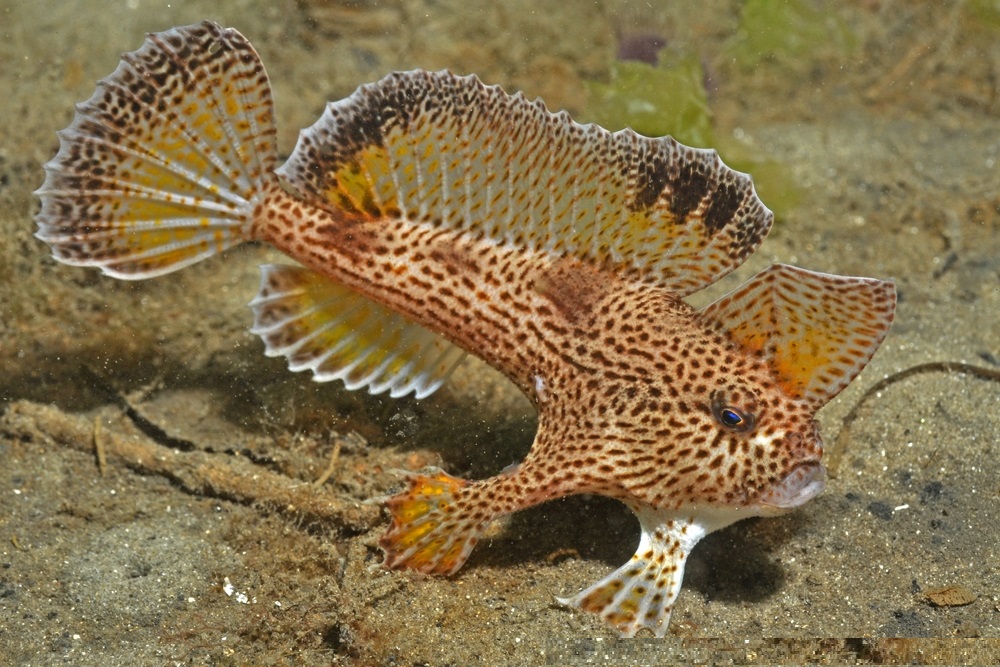
The rare spotted handfish (Brachionichthys hirsutus), whose only habitat is in the Derwent estuary and surrounds, The fish is threatened by the Northern Pacific seastar's invasion into southern Australian waters. The Northern Pacific seastar (Asterias amurensis), now firmly established in the Derwent, preys on not only the fish eggs, but also on the sea squirts (ascidians) that help to form the substrate that the fish spawn on.
Bridges
Several bridges connect the western shore (the more heavily populated side of the river) to the eastern shore of Hobart – in the greater Hobart area, these include the five lane Tasman Bridge, near the CBD, just north of the port; the four lane Bowen Bridge; and the four lane Bridgewater Bridge. Until 1964 the Derwent was crossed by the unique Hobart Bridge, a floating concrete structure just upstream from where the Tasman Bridge now stands.
Travelling further north from the Bridgewater crossing, the next crossing point is the Blair Street Bridge at New Norfolk, slightly north of the point where the Derwent reverts from seawater to fresh water, Bushy Park, Upper Meadowbank Lake, Lake Repulse Road, Wayatinah, and the most northerly crossing is at Derwent Bridge, before the river reaches its source of Lake St Clair. At the Derwent Bridge crossing, the flow of the river is generally narrow enough to be stepped across.
Cultural references
The river is the subject of the multimedia performance "Falling Mountain" (2005 Mountain Festival), a reference to the mountain in the Cradle Mountain-Lake St Clair National Park from which the river rises.
The Derwent is mentioned in the song, Mt Wellington Reverie by Australian band, Augie March. Hobart is located in the foothills of Mount Wellington.
Panoramas
References
References
- (2015). "Map of River Derwent, TAS". Bonzle Digital Atlas of Australia.
- (June 2009). "Derwent Estuary and its catchment". [[Australian Government]].
- "Tasmanian Aboriginal Centre – nipaluna".
- (16 October 2014). "Catchment and flow". Derwent Estuary Program.
- [http://web.ukonline.co.uk/sw.rae/rivers.htm Names of Rivers] {{webarchive. link. (18 July 2006 web.ukonline.co.uk)
- [http://www.yorksj.ac.uk/dialect/celtpn.htm Celtic Place Names] {{webarchive. link. (6 December 2007 www.yorksj.ac.uk)
- Observations on the coasts of Van Diemen's Land, on Bass's Strait and its islands, and on parts of the coasts of [[New South Wales]]; intended to accompany the charts of the late discoveries in those countries. By Matthew Flinders, second lieutenant of His Majesty's Ship Reliance.published by John Nichols 1801* page 5
- [https://www.placenames.tas.gov.au Nomenclature Board of Tasmania] Nomenclature number 470L
- [http://www.parliament.tas.gov.au/ha/So&Sessionals.pdf Parliament of Tasmania – House of Assembly Standing Orders] {{webarchive. link. (4 June 2009 "We acknowledge the traditional people of the land upon which we meet today, the Mouheneener people.")
- "River Derwent".
- Roe, Margriet. (1966). "Hayes, Sir John (1768–1831)".
- (25 July 2008). "A History of Shore-Based Whaling". Parks.tas.gov.au.
- [https://tasmania.com/points-of-interest/river-derwent Tasmania] River Derwent Length and Geography
- "Shipping Movements List for Hobart". [[TasPorts]].
- Shannon, Lucy. (23 April 2015). "River Derwent: Heavy metal contamination decreases, effluent increases, report finds". [[ABC News (Australia).
- Ruth Barton. "Communal life, common interests and healthy conditions".
- "Investigation of heavy metals in soil and vegetation around the Pasminco Metals-EZ refinery, Hobart : stage 1". Dept. of Environment and Planning.
- "Heavy metals in soil and vegetation in the vicinity of the Pasminco Metals-EZ refinery, Hobart". Dept. of Environment and Planning.
- "Investigation of heavy metals in indoor dust, soils and home-grown vegetables : investigations in the vicinity of the Pasminco Metals-EZ refinery, Hobart". Dept. of Environment and Land Management.
- "Development proposal & environmental management plan : a proposal to implement the paragoethite co-treatment process at Pasminco Metals-EZ". [[Pasminco]].
- "It's mighty mouth: Whales feeding in River Derwent". Mercury.
- Shiffman, David. (July 2020). "Smooth Handfish Extinction Marks a Sad Milestone". [[Scientific American]].
- Edgar, G., Stuart-Smith, R. & Last, P.R. (2020). ''Brachionichthys hirsutus''. The IUCN Red List of Threatened Species. {{doi. 10.2305/IUCN.UK.2020-1.RLTS.T2958A121210485.en
- (5 November 2020). "Species - Asterias amurensis". Australian Government.
- "Brachionichtys-hirsutus".
- (10 March 2010). "Asterias amurensis". [[Invasive Species Specialist Group]] (ISSG).
- MacDonald, Lucy. (20 February 2021). "Volunteers hope efforts to remove invasive northern Pacific seastar will make a difference". [[Australian Broadcasting Corporation]].
- (5 January 1975). "Parliament of Tasmania History site – Hobart to Tasman Bridge". Parliament.tas.gov.au.
- "AUGIE MARCH - lyrics".
This article was imported from Wikipedia and is available under the Creative Commons Attribution-ShareAlike 4.0 License. Content has been adapted to SurfDoc format. Original contributors can be found on the article history page.
Ask Mako anything about River Derwent (Tasmania) — get instant answers, deeper analysis, and related topics.
Research with MakoFree with your Surf account
Create a free account to save articles, ask Mako questions, and organize your research.
Sign up freeThis content may have been generated or modified by AI. CloudSurf Software LLC is not responsible for the accuracy, completeness, or reliability of AI-generated content. Always verify important information from primary sources.
Report