From Surf Wiki (app.surf) — the open knowledge base
Reedy River
| Field | Value |
|---|---|
| name | Reedy River |
| image | reedy-river-conestee.jpg |
| image_size | 250px |
| image_caption | The Reedy River in Lake Conestee Nature Park |
| source1_location | Greenville County, South Carolina |
| source1_coordinates | |
| source1_coord_ref | |
| mouth_location | Saluda River |
| mouth_coordinates | |
| length_mi | 65 |
the river
The Reedy River is a tributary of the Saluda River, about 65 mi long, in northwestern South Carolina in the United States. Via the Saluda and Congaree rivers, it is part of the watershed of the Santee River, which flows to the Atlantic Ocean.
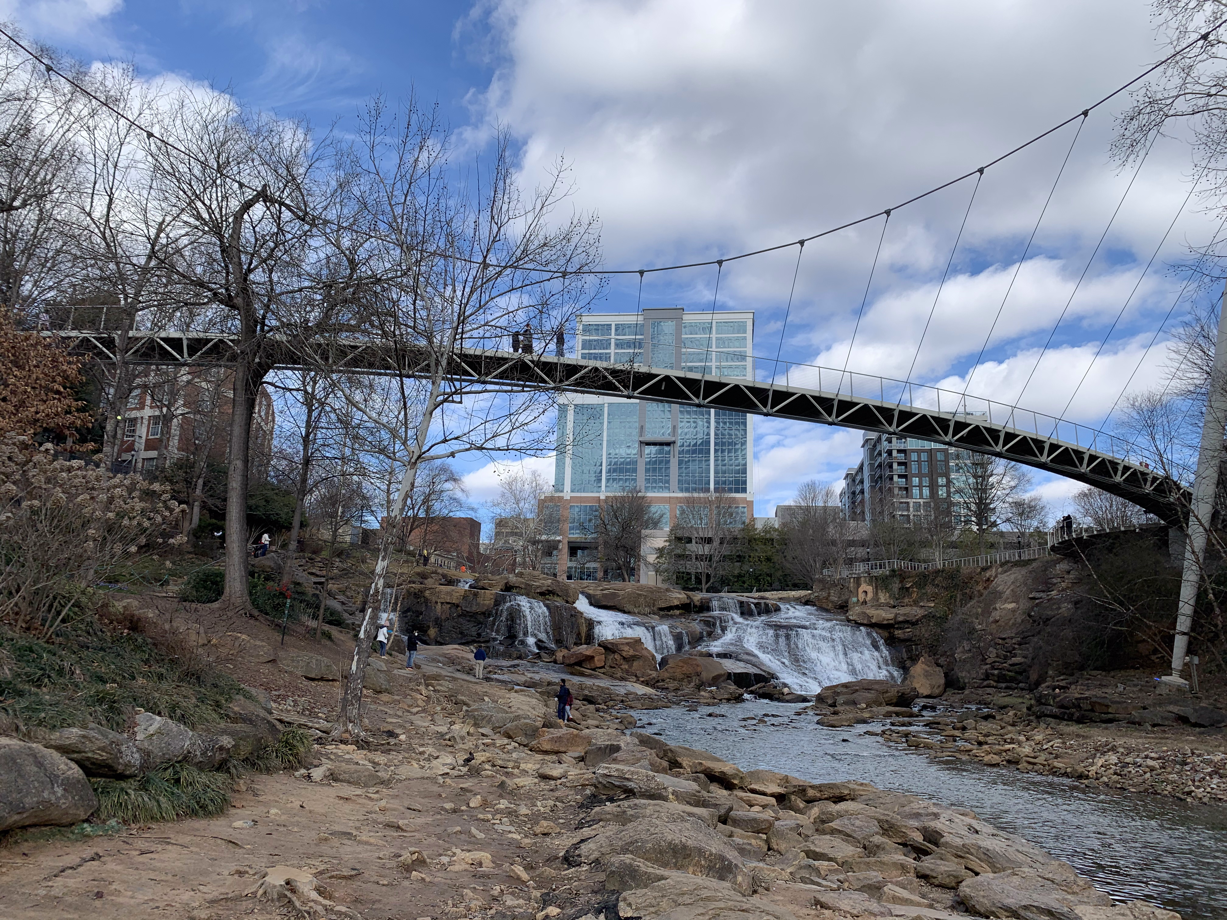
The Reedy River Falls: Big Brother
Big Brother, or "The Falls", is a large waterfall that flows through Falls Park in Greenville, South Carolina. It is overseen by the Liberty Bridge. Sliding down the falls is illegal according to Greenville law, but it is still practiced by many kayakers and other adventure seekers.
Course
The Reedy River rises in Greenville County in the foothills of the Blue Ridge Mountains, about 10 mi northwest of the city of Greenville, and flows generally south-southeastwardly through Greenville, Lake Conestee Nature Park, and the Piedmont region into Laurens County. It joins the Saluda River in Laurens County, 9 mi northeast of Greenwood, as part of Lake Greenwood, which is formed by a dam on the Saluda.
Pollution
The pollution in the river was identified to be unfit for humans because of E. coli. Children were commonly seen sliding down rocks in a section of the river in Falls Park and the practice is now discouraged by signage and mild policing. Though it's not necessarily unsafe to wade in the waters, it's under studied.
There are ongoing efforts to improve water quality along the whole of the Reedy River by the city, volunteers, and private companies. Educating on clean water practices (e.g. Cleaning up after pets in the park) and Enacting programs such as 319 grant that offer grants to people with septic malfunctions instead of letting the issue go without maintenance, polluting ground water.
Crossings
The following is a list of crossings of the Reedy River from Greenville downstream starting in downtown Greenville at US 123. This list may at times be incomplete.
- City of Greenville
- US 123/S Academy Street
- River Street bridge
- Pedestrian bridge at the Peace Center, converted from a former railroad bridge
- Main Street bridge at Camperdown
- Liberty Bridge
- US 29/S Church Street
- McDaniel Avenue
- Woodland Way in Cleveland Park
- E Faris Road
- Cleveland Street
- S Pleasantburg Drive, SC 291
- Interstate 85
- Greenville County
- Mauldin Road
- Conestee Road
- Ashmore Bridge Road
- Interstate 185
- Log Shoals Road
- W Georgia Road
- New Harrison Bridge Road
- Jenkins Bridge Road and SC 418
- McKelvey Road in Fork Shoals
- McKittrick Bridge Road
- Hillside Church Road
- Dunklin Bridge Road
- Laurens County
- US 76 in Hickory Tavern
- SC 252
- Ekom Beach Road
- Indian Mound Road
- Riverfork Road over Lake Greenwood
Sources
- Columbia Gazetteer of North America entry
- DeLorme (1998). South Carolina Atlas & Gazetteer. Yarmouth, Maine: DeLorme. .
- American Whitewater
References
References
- {{cite gnis. 1225823. Reedy River
- "How OK is it to wade in Falls Park?".
- "Water Quality {{!}} Greenville, SC - Official Website".
This article was imported from Wikipedia and is available under the Creative Commons Attribution-ShareAlike 4.0 License. Content has been adapted to SurfDoc format. Original contributors can be found on the article history page.
Ask Mako anything about Reedy River — get instant answers, deeper analysis, and related topics.
Research with MakoFree with your Surf account
Create a free account to save articles, ask Mako questions, and organize your research.
Sign up freeThis content may have been generated or modified by AI. CloudSurf Software LLC is not responsible for the accuracy, completeness, or reliability of AI-generated content. Always verify important information from primary sources.
Report