From Surf Wiki (app.surf) — the open knowledge base
Rātana Pā
Settlement in Manawatū-Whanganui Region, New Zealand
Settlement in Manawatū-Whanganui Region, New Zealand
| Field | Value |
|---|---|
| name | Ratana Community |
| native_name | Rātana Pā |
| native_name_lang | mi |
| settlement_type | Town |
| image_skyline | The temple at Ratana Pa, Whanganui.jpg |
| imagesize | 220px |
| image_alt | The temple at Rātana Pā |
| image_caption | The temple at Rātana Pā |
| mapframe | yes |
| mapframe-zoom | 9 |
| coordinates | |
| subdivision_type | Country |
| subdivision_name | New Zealand |
| subdivision_type2 | Region |
| subdivision_name2 | Manawatū-Whanganui |
| subdivision_type3 | District |
| subdivision_name3 | Rangitikei District |
| subdivision_type4 | Wards |
| subdivision_name4 | |
| seat_type | Electorates |
| seat | |
| leader_title | Territorial Authority |
| leader_name | Rangitikei District Council |
| leader_title1 | Regional council |
| leader_name1 | Horizons Regional Council |
| leader_title2 | Mayor of Rangitikei |
| leader_name2 | |
| leader_title3 | Rangitīkei MP |
| leader_name3 | |
| leader_title4 | Te Tai Hauāuru MP |
| leader_name4 | |
| area_footnotes | |
| area_total_km2 | 0.29 |
| population_footnotes | |
| population_as_of | |
| population_total | |
| population_density_km2 | auto |
| postal_code_type |
| mapframe-zoom = 9 Rātana Pā, or Ratana Community, is a town in the North Island of New Zealand, near Whanganui and Marton in the Manawatū-Whanganui region. The locality was the farm of Tahupōtiki Wiremu Rātana, the founder of a Māori religious and political movement, and the settlement developed in the 1920s as followers came to see Rātana. It continues as the centre of the Rātana Church. Due to the importance of the Rātana movement in New Zealand politics, leading New Zealand politicians often attend annual gatherings at Rātana Pā.
Location
Rātana Pā is 20 km south-east of Whanganui, 5 km west of Turakina and 19 km west of Marton. It lies between State Highway 3 and the coast.
History
Rātana Pā is on what was the farm of Tahupōtiki Wiremu Rātana, the founder of the Rātana religious and political movement and the Rātana Church. The locality became a settlement of Rātana followers in the 1920s.
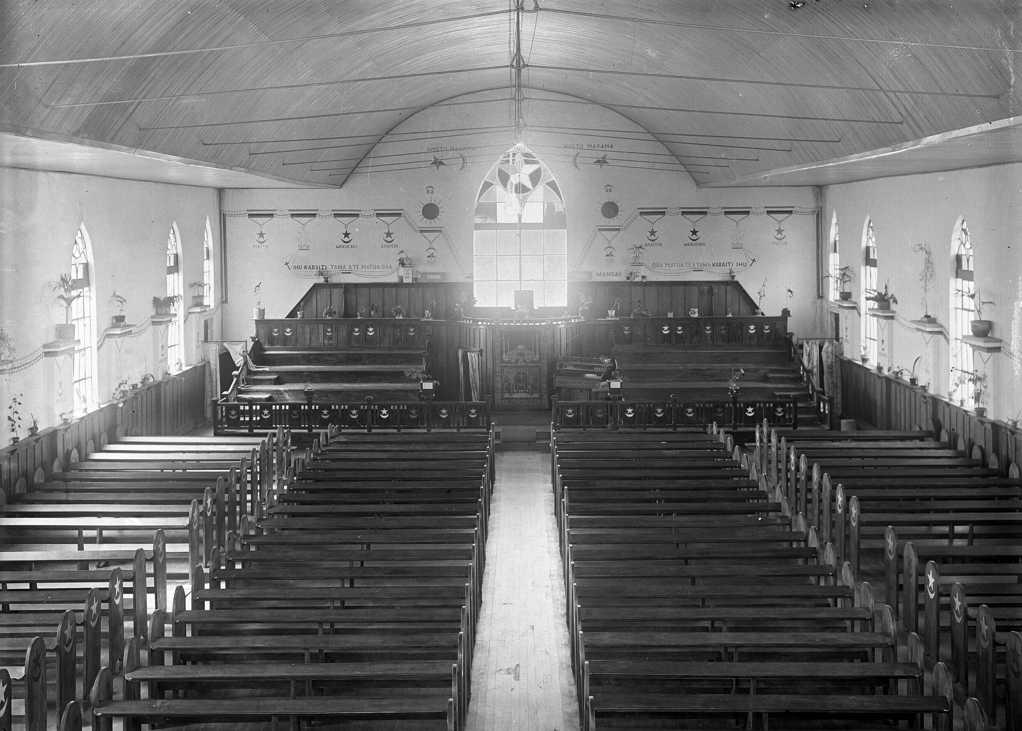
Facilities at Rātana Pā include the 1,000-seat Temepara Tapu o Ihoa (Holy Temple of Jehovah), the Manuao (an accommodation facility and head office of the church), the Whare Māori (which contains crutches and wheelchairs from followers who were healed by Rātana in the 1920s and 1930s) and the Ratana Archives Centre, which contains artefacts and stories from the history of the Rātana Church.
25 January and 8 November are anniversary days of the Rātana Church. On these days thousands of members of the church converge on Rātana Pā for the special anniversary services commemorating the birth of Rātana (25 January 1873) and his first spiritual vision (8 November 1918). The gathering for the birth anniversary lasts for a week, with the highlight being the Temple Service on 25 January. Usually, Members of Parliament (MPs) visit on 24 January to talk and seek the votes of Māori.
On 10 November 2024, the Sixth National Government allocated NZ$10.1 million from the Regional Infrastructure Fund to building upgrades and repairs at Rātana Pā.
Government and politics
Local government
Rātana Pā is in the Southern ward of Rangitikei District, which elects two of the eleven members of the Rangitikei District Council. There is also a Rātana Community Board, one of two community boards in the District (the other being for Taihape). The Board has four elected members and one appointed councillor from the Southern ward.
National government
Rātana Pā, like the rest of the Rangitikei District, is located in the general electorate of Rangitīkei and in the Māori electorate of Te Tai Hauāuru. Rangitīkei is a safe National Party seat since the 1938 election with the exception of 1978–1984 when it was held by Bruce Beetham of the Social Credit Party. Since 2023 it has been held by Suze Redmayne.
Te Tai Hauāuru is a more volatile seat, having been held by three different parties since 1996, i.e. New Zealand First, Te Pāti Māori and the Labour Party. Since 2023 it has been held by Debbie Ngarewa-Packer of the Māori Party.
Demographics
Rātana is described by Statistics New Zealand as a rural settlement. It covers 0.29 km2 and had an estimated population of as of with a population density of people per km2. It is part of the larger Turakina statistical area.

Rātana had a population of 351 in the 2023 New Zealand census, an increase of 3 people (0.9%) since the 2018 census, and an increase of 21 people (6.4%) since the 2013 census. There were 156 males and 195 females in 108 dwellings. 2.6% of people identified as LGBTIQ+. The median age was 39.4 years (compared with 38.1 years nationally). There were 66 people (18.8%) aged under 15 years, 72 (20.5%) aged 15 to 29, 162 (46.2%) aged 30 to 64, and 51 (14.5%) aged 65 or older.
People could identify as more than one ethnicity. The results were 12.0% European (Pākehā), 95.7% Māori, 3.4% Pasifika, 0.9% Asian, and 1.7% other, which includes people giving their ethnicity as "New Zealander". English was spoken by 94.0%, Māori by 41.0%, Samoan by 1.7%, and other languages by 0.9%. No language could be spoken by 2.6% (e.g. too young to talk). The percentage of people born overseas was 1.7, compared with 28.8% nationally.
Religious affiliations were 6.0% Christian, and 86.3% Māori religious beliefs. People who answered that they had no religion were 6.0%, and 2.6% of people did not answer the census question.
Of those at least 15 years old, 42 (14.7%) people had a bachelor's or higher degree, 153 (53.7%) had a post-high school certificate or diploma, and 90 (31.6%) people exclusively held high school qualifications. The median income was $34,000, compared with $41,500 nationally. 9 people (3.2%) earned over $100,000 compared to 12.1% nationally. The employment status of those at least 15 was 150 (52.6%) full-time, 27 (9.5%) part-time, and 15 (5.3%) unemployed.
Transport
State Highway 3 [[File:State Highway 3 NZ.svg|20px|link=New Zealand State Highway 3]] is located 2 km to the northeast of Rātana Pā. This national state highway connects Woodville (25 km east of Palmerston North) and Hamilton via New Plymouth.
InterCity runs three daily and six non-daily services at the Ratana Turn Off stop. These include Palmerston North–Auckland, Wellington–New Plymouth and Auckland–Palmerston North.
The nearest airport is Whanganui Airport, located 22 km to the northwest of the town.
Rātana had a railway station on the Marton–New Plymouth line from 27 April 1898, for goods, and 23 May for passengers. It had a shelter shed, platform, loading bank and a small passing loop. The station closed on 7 December 1947, when the Turakina Deviation diverted the railway away from Rātana. Seven died due to a crash on 26 March 1938, 1 mi from the station, to the north of Lake Waipu.
Education
Te Kura o Ratana is a state-integrated co-educational Rātana Church primary school for Year 1 to 8 students, with a roll of as of .
The nearest secondary schools are in Whanganui and Marton.
Table footnotes
References
References
- Newman, Keith. "The Founding of a Faith". New Zealand Historic Places Trust.
- (10 November 2024). "Government gives $10 million each to Waitangi Treaty Grounds and Rātana Pā". [[Stuff (website).
- "Community Boards". Rangitīkei District Council.
- (26 April 2019). "Change to Rangitīkei District Council ward structure from 5 to 3". Rangitīkei District Council.
- "Find my Electorate". [[Electoral Commission (New Zealand).
- (20 December 2023). "Redmayne, Suze". [[New Zealand Parliament]].
- (30 September 2012). "Te Tai Hauāuru Electorate Profile". [[New Zealand Parliament]].
- (14 December 2023). "Ngarewa-Packer, Debbie". [[New Zealand Parliament]].
- "Stats NZ Geographic Data Service".
- "Geographic Boundary Viewer". Stats NZ.
- {{NZ census 2018. 7017973 and 7017974
- "2013 Census QuickStats about a place: Ratana Community". [[Statistics New Zealand]].
- "Totals by topic for dwellings, (RC, TALB, UR, SA3, SA2, Ward, Health), 2013, 2018, and 2023 Censuses". Stats NZ – Tatauranga Aotearoa – Aotearoa Data Explorer.
- "Totals by topic for individuals, (RC, TALB, UR, SA3, SA2, Ward, Health), 2013, 2018, and 2023 Censuses". Stats NZ – Tatauranga Aotearoa – Aotearoa Data Explorer.
- (1 February 2016). "Ratana Turn Off – Bus Timetable". [[InterCity (New Zealand).
- Scoble, Juliet. "Station Archive".
- (21 July 1938). "RATANA RAILWAY SMASH Wanganui Chronicle".
- (1942). "1:63360 map Sheet: N143 Marton".
- "Ministry of Education School Profile". [[Ministry of Education (New Zealand).
- "Education Review Office Report". [[Education Review Office]].
This article was imported from Wikipedia and is available under the Creative Commons Attribution-ShareAlike 4.0 License. Content has been adapted to SurfDoc format. Original contributors can be found on the article history page.
Ask Mako anything about Rātana Pā — get instant answers, deeper analysis, and related topics.
Research with MakoFree with your Surf account
Create a free account to save articles, ask Mako questions, and organize your research.
Sign up freeThis content may have been generated or modified by AI. CloudSurf Software LLC is not responsible for the accuracy, completeness, or reliability of AI-generated content. Always verify important information from primary sources.
Report