From Surf Wiki (app.surf) — the open knowledge base
Ramarama, New Zealand
.jpg)
| Field | Value |
|---|---|
| name | Ramarama |
| native_name_lang | |
| mapframe | yes |
| mapframe-zoom | 11 |
| pushpin_label_position | left |
| coordinates | |
| subdivision_type | Country |
| subdivision_name | New Zealand |
| subdivision_type1 | Region |
| subdivision_name1 | Auckland Region |
| subdivision_type2 | Ward |
| subdivision_name2 | Franklin ward |
| subdivision_type3 | Board |
| subdivision_name3 | Franklin Local Board |
| leader_title | Territorial Authority |
| leader_name | Auckland Council |
| leader_title2 | Mayor of Auckland |
| leader_name2 | |
| leader_title3 | Papakura MP |
| leader_name3 | |
| leader_title4 | Hauraki-Waikato MP |
| leader_name4 | |
| seat_type | Electorates |
| seat | |
| unit_pref | Metric |
| area_total_km2 | 39.69 |
| area_footnotes | |
| population_total | |
| population_as_of | |
| population_footnotes | |
| population_density_km2 | auto |
| website |
| mapframe-zoom = 11 tags --
Ramarama, previously known as Sheppards Bush, is a small community at the far south of the Auckland Region in New Zealand's North Island, located just to the north of the Bombay Hills (a point commonly regarded as the most southern part of the Auckland region). Ramarama has an off-ramp at exit 466 on the motorway south of Auckland. The suburb is effectively sliced in two by the motorway, this section of which was constructed in 1978.
The main settlement of Ramarama contains a convenience store and several small businesses. Most of the land in the area is made up of market gardens, farms and lifestyle blocks as would be expected from the entirely rural region in which it is located. There are several floral/garden/nursery businesses with large glasshouses and a number of poultry/egg producing farms in the surrounding area.
Ramarama is named after ramarama, a small tree with leaves that can cure bruises if crushed.
History
Ramarama was originally only bushland and also there was a pā site inhabited by the Ngāti Pou tribe of the Māori. It also hid pathways between Tamaki, Hauraki and the Waikato.
In the 1850s, the British built the Great South Road through the land. At the time of the Waikato War, the area was known as Sheppards Bush.
Reverend McDonald, a famed priest at the time, decided to build a church, where the Pratts Road Cemetery stands now. The church was called Saint Brigids and also functioned as a school. The church itself was moved to Selwyn Oaks, but the school was called Maketu School and henceforth Ramarama School.
The Te Maketu Waterfall is hidden behind the Pratts Road Cemetery. Reverend McDonald wrote a book on it called The Well Known Secret of the Waterfall.
- Country Women's Institute
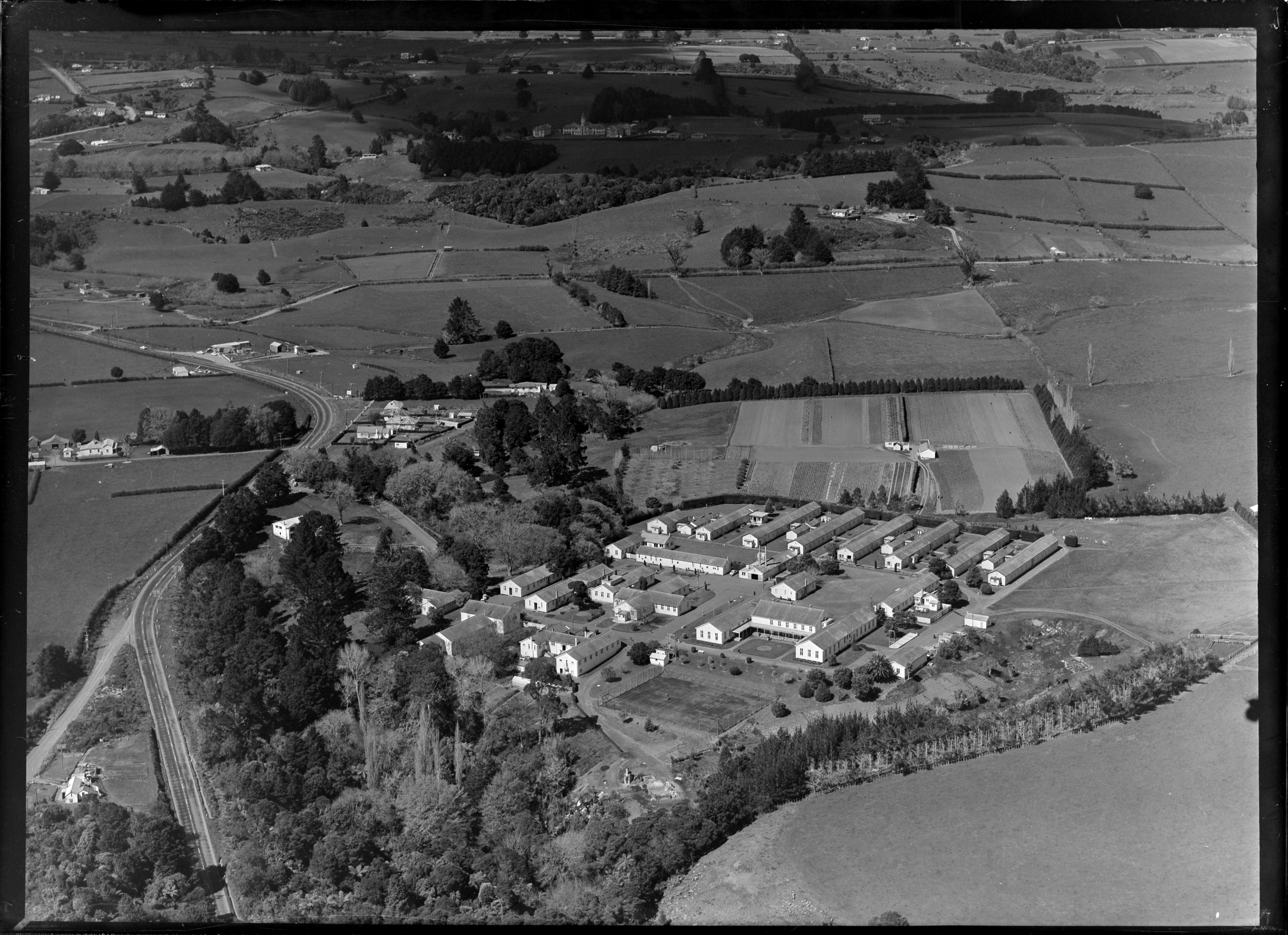
The Northern Military District Convalescent Depot, opened in December 1942 as a place for troops to recover. It was between Ramarama and Bombay. In late 1945, ash from Ruapehu polluted the water supply of The Grand Chateau and patients who had been housed there were evacuated to what then became Raventhorpe psychiatric hospital. At the 1951 Census 278 people were living at the hospital. The hospital closed about 1991 and the land was sold, to become what is now Martyn Farm Estate.
Demographics
Ramarama statistical area, which also includes Paerata, covers 39.69 km2 and had an estimated population of as of with a population density of people per km2.
Ramarama had a population of 2,931 in the 2023 New Zealand census, an increase of 1,119 people (61.8%) since the 2018 census, and an increase of 1,143 people (63.9%) since the 2013 census. There were 1,509 males, 1,416 females and 9 people of other genders in 1,008 dwellings. 1.9% of people identified as LGBTIQ+. The median age was 39.0 years (compared with 38.1 years nationally). There were 558 people (19.0%) aged under 15 years, 510 (17.4%) aged 15 to 29, 1,428 (48.7%) aged 30 to 64, and 435 (14.8%) aged 65 or older.
People could identify as more than one ethnicity. The results were 75.8% European (Pākehā); 10.4% Māori; 8.4% Pasifika; 14.2% Asian; 1.3% Middle Eastern, Latin American and African New Zealanders (MELAA); and 2.3% other, which includes people giving their ethnicity as "New Zealander". English was spoken by 96.3%, Māori language by 1.7%, Samoan by 1.2%, and other languages by 16.7%. No language could be spoken by 2.0% (e.g. too young to talk). New Zealand Sign Language was known by 0.4%. The percentage of people born overseas was 27.6, compared with 28.8% nationally.
Religious affiliations were 34.8% Christian, 3.6% Hindu, 0.9% Islam, 0.4% Māori religious beliefs, 0.7% Buddhist, 0.2% New Age, 0.1% Jewish, and 2.3% other religions. People who answered that they had no religion were 51.7%, and 5.6% of people did not answer the census question.
Of those at least 15 years old, 693 (29.2%) people had a bachelor's or higher degree, 1,200 (50.6%) had a post-high school certificate or diploma, and 486 (20.5%) people exclusively held high school qualifications. The median income was $58,000, compared with $41,500 nationally. 537 people (22.6%) earned over $100,000 compared to 12.1% nationally. The employment status of those at least 15 was that 1,389 (58.5%) people were employed full-time, 321 (13.5%) were part-time, and 66 (2.8%) were unemployed.
Education
Ramarama School is a coeducational full primary school (years 1–8) with a roll of as of The school was founded in 1867.
Places of interest

Te Maketu Falls – This is a tranquil waterfall about five minutes' walk from Pratts Rd Cemetery. With a large swimming hole at the base of the waterfall, it is an awe-inspiring place to walk to, have a swim or photograph.
Pratts Road Cemetery – A place to remember the dead, especially soldiers who fought in the war
St Brigid's Church site – This is the site of the Catholic Church that was closed down in 1969, 45 years after it was opened in 1924. As most of the English and Irish immigrants were Catholic it was decided that a church be opened for bible and Sunday school sessions.
Notable people
- Jane Mander, novelist, was born in Ramarama on 9 April 1877.
References
References
- "Ramarama Travel Guide". [[Jasons Travel Media]].
- Reed, A. W.. (2010). "Place Names of New Zealand". Raupo.
- "Ramarama School}} {{Retrieved".
- "23 December 1942".
- (1964). "1:63360 map Sheet: N46-47 Pukekohe".
- (23 August 1948). "Chateau reopens NORTHERN ADVOCATE".
- "1951 Census – Part 01 – Increase and Location of Population 1951".
- "5 March 1991".
- (Feb 2020). "1704 Great South Rd".
- "Stats NZ Geographic Data Service".
- {{NZ census 2018. Ramarama (165100). ramarama. Ramarama
- "Totals by topic for dwellings, (RC, TALB, UR, SA3, SA2, Ward, Health), 2013, 2018, and 2023 Censuses". Stats NZ – Tatauranga Aotearoa – Aotearoa Data Explorer.
- "Totals by topic for individuals, (RC, TALB, UR, SA3, SA2, Ward, Health), 2013, 2018, and 2023 Censuses". Stats NZ – Tatauranga Aotearoa – Aotearoa Data Explorer.
- {{TKI. 1456. Ramarama School
- (4 September 2017). "Ramarama School getting set to celebrates 150-year milestone". Franklin County News.
- "St Brigids Parish}} {{Retrieved".
This article was imported from Wikipedia and is available under the Creative Commons Attribution-ShareAlike 4.0 License. Content has been adapted to SurfDoc format. Original contributors can be found on the article history page.
Ask Mako anything about Ramarama, New Zealand — get instant answers, deeper analysis, and related topics.
Research with MakoFree with your Surf account
Create a free account to save articles, ask Mako questions, and organize your research.
Sign up freeThis content may have been generated or modified by AI. CloudSurf Software LLC is not responsible for the accuracy, completeness, or reliability of AI-generated content. Always verify important information from primary sources.
Report