From Surf Wiki (app.surf) — the open knowledge base
Queen Street, Brisbane
Street in Brisbane's CBD
Street in Brisbane's CBD
| Field | Value |
|---|---|
| type | street |
| urban | yes |
| road_name | QueenStreet, Brisbane |
| state | qld |
| image | Queen Street with 443 Queen Street in the background, Brisbane, January 2021, 01.jpg |
| caption | View from Queen Street Mall |
| image_alt | View of the street from Queen Street Mall |
| direction_a | West |
| end_a | Victoria Bridge, North Quay |
| exits | George Street, Albert Street, Edward Street, Creek Street, Adelaide Street |
| direction_b | East |
| end_b | Ann Street |
| lga | City of Brisbane |
| restrictions | Partially pedestrianised |
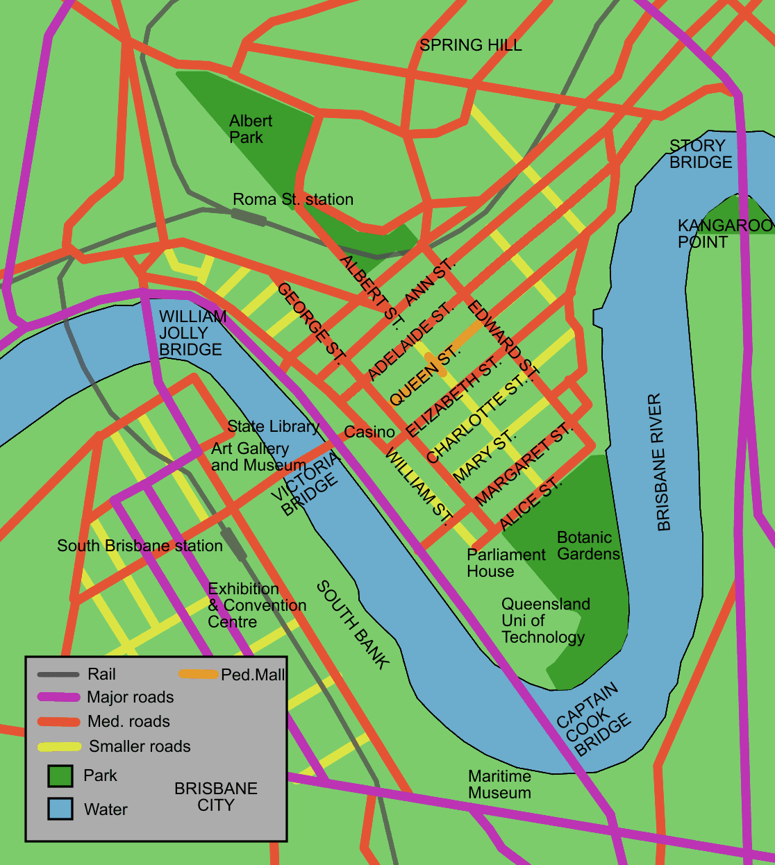
Queen Street is the main street of Brisbane, the capital of Queensland, Australia. It is named after Queen Victoria.
The western part of the street is covered by a new plaza at the base of Brisbane Square and underneath part of the western half is the Queen Street bus station.
Queen Street is heavily built up with arcades, shops, hotels, offices and apartment high-rises such as MacArthur Central, Brisbane Square, Central Plaza, Aurora Tower, Treasury Casino, Wintergarden, Broadway on the Mall, The Myer Centre and QueensPlaza. Queen Street is also the location of Brisbane's General Post Office.
Geography
Queen Street is the city's central road, partly covered by a pedestrian mall called the Queen Street Mall. It ends at the Victoria Bridge and is bounded by two of the Brisbane River's central reaches. Uptown at the top of the mall is George Street.
The next street parallel to the south is Elizabeth Street, while Adelaide Street is the next parallel street to the north.
History


Before 1842 and free settlement, Queen Street was originally a track leading from the main section of the early Moreton Bay Penal Colony, crossing a stream known as Wheat Creek with a deviation going up to the Windmill. In early 1840, a surveyor named Dixon drew up a survey for the central Brisbane streets with all streets 66 ft wide. Changes were then made to this plan with square blocks flattened into a rectangular grid with streets becoming 1.4 chains (27 metres). On Governor Gipps' visit to Brisbane Town in March 1842, Gipps remarked that Brisbane Town was "simply an ordinary provincial settlement", which would need no grand avenues. As a result, Gipps moved the planned width of Queen Street, along with other streets, back to 66 ft, arguing that this change would mean that buildings could be kept out of the sun.
Later, there was compromise with the main street that would be known as Queen Street, with the western boundary's width changed to 1.2 chains (24 metres).
The first sitting of Legislative Assembly of Queensland in May 1860 occurred in the old converted convict barracks on Queen Street.
In 1864, there were two significant fires along the street. The September 1864 fire started in the Little Wonder store on Edward Street which destroyed 14 shops in Queen Street. This event later became known as Bulcock's Fire. On 1 December 1864, the Great Fire of Brisbane started within the cellar of a Queen Street drapery store which burnt down buildings bordering Queen Street, as well as Albert Street, Edward Street, George Street and Elizabeth Street. Brisbane Courier described the fire as "the whole of the business premises and private residences...were, in a couple of hours, reduced to a heap of ruins".
On 9 December 1882, a demonstration of electricity was conducted with eight arc lights along Queen Street. Power was supplied by a 10 hp generator driven by a small engine in a foundry in Adelaide Street. This was Australia's first recorded use of electricity for public purposes.
In 1885, Poul C. Poulsen opened his photographic studio at 7 Queen Street. Ada Driver trained at Poulson's studio before opening her own photographic studio, ‘Ada Driver’s Studio’, at 51 Queen street in 1906.
In 1902, part of Queen Street was not paved or sealed although stormwater drainage was well maintained.
Queen Street is historically significant as it contains MacArthur Central, the building in which the American General Douglas MacArthur had his South West Pacific headquarters (from July 1942 to November 1944) during World War II and directed the Allied Forces campaign. The former AMP building was later renamed MacArthur Central as a tribute to General MacArthur.
Tram services along Queen Street were converted to buses on 14 April 1969.
In 1981, the part of the street between Albert Street and Edward Street was closed to traffic. This section was opened as the Queen Street Mall in 1982, in time for the Commonwealth Games. Later, the section between Albert Street and George Street was converted into an extension of the pedestrian mall, timed to coincide with Brisbane's Expo '88.
A number of buildings were demolished on Queen Street in the 1980s, including Her Majesty's Theatre, the Wintergarden cinema and the Odeon cinema as the mall development proceeded.
Heritage listings
There are many heritage-listed buildings in Queen Street, including:
- 21 Queen Street: Treasury Building
- 33 Queen Street: Bank of New South Wales Building
- 43 Queen Street: Trustees Chambers
- 62 Queen Street: Colonial Mutual Chambers
- 86 Queen Street: Palings Building (also known as City International Duty Free)
- 110 Queen Street: Allan and Stark Building (also known as former Myer Store)
- 114 Queen Street: Gardams Building
- 116 Queen Street: Hardy Brothers Building
- 120 Queen Street: Edwards and Chapman Building
- 160 Queen Street: Brisbane Arcade
- 167 Queen Street: Regent Theatre
- 180 Queen Street: National Australia Bank (180 Queen Street)
- 196 Queen Street: Finney Isles & Co Building
- 229 Queen Street: MacArthur Chambers
- 270 Queen Street: Sir William Glasgow Memorial
- 289 Queen Street: Newspaper House (now the Manor Apartment Hotel)
- 299 Queen Street: National Mutual Life Building
- 308 Queen Street: National Australia Bank (308 Queen Street) and its First World War Honour Board (separate listings)
- 424–426 Queen Street: Queensland Country Life Building facade
- 427 Queen Street: former Brisbane Customs House
- 443–501 Queen Street: Petrie Bight Retaining Wall
- 560 Queen Street: Orient Hotel The present Hungry Jacks fast food restaurant occupies Beak House, a listed building previously owned by a farming and investment company. The present McDonald's restaurant is located directly opposite in the building formerly occupied by Jo Jo's Restaurant.
Major intersections
- North Quay / William Street
- George Street
- Albert Street
- Edward Street
- Creek Street
- Wharf Street / Eagle Street
- Adelaide Street
- Ann Street
References
References
- "Queensland Place Histories: Queen Street, Brisbane".
- Armstrong, Lyn. (1997). "Brisbane:Corridors of Power". Brisbane History Group Inc.
- Laverty, John. (2009). "The Making of a Metropolis: Brisbane 1823–1925". Boolarong Press.
- (5 September 1864). "Fire in Edward-Street". [[The Brisbane Courier]].
- [http://www.archives.qld.gov.au/Researchers/Exhibitions/QldFirsts/01-25/Pages/4.aspx Queensland State Archives. 1860 – Fiery beginnings] {{Webarchive. link. (27 November 2014 , Queensland State Archives.)
- "The Great Fire of Brisbane, 1864".
- Dunn, Col. (1985). "The History of Electricity in Queensland". Col Dunn.
- Myles Sinnamon. (15 September 2015). "Early Queensland photography - Poulsen Studios".
- "Driver, Ada Annie".
- "DRIVER, ADA (G)".
- Cole, John R.. (1984). "Shaping a city". William Brooks Queensland.
- "General Headquarters (GHQ), South West Pacific Area, Queen Street, Brisbane".
- "MacArthur's War Chambers, Brisbane".
- Cole, John R.. (1984). "Shaping a city". William Brooks Queensland.
- "'Flashback' – Queen St Closure". BTQ7 News.
- "Queen Street Mall's 30-year evolution". Brisbanetimes.com.au.
- {{cite QHR. 14918. Treasury Building. 600143
- {{cite QHR. 14929. Westpac Bank Building. 600154
- {{cite QHR. 14932. ANZ Bank. 600157
- {{cite QHR. 14935. 62 Queen Street. 600160
- {{cite QHR. 14936. City International Duty Free. 600161
- {{cite QHR. 14937. Myer Store (former) [incorporating Miss Brisbane 600136]. 600162
- {{cite QHR. 14911. Building - Miss Brisbane [incorporated in Myer Store (former) see 600162]. 600136
- {{cite QHR. 14912. Gardams. 600137
- {{cite QHR. 14913. Hardy Brothers. 600138
- {{cite QHR. 14914. Sportsgirl. 600139
- {{cite QHR. 14833. Brisbane Arcade. 600058
- {{cite QHR. 14915. Regent Building. 600140
- {{cite QHR. 14916. National Australia Bank. 600141
- {{cite QHR. 14917. David Jones. 600142
- {{cite QHR. 14922. MacArthur Chambers. 600147
- {{cite QHR. 19561. Sir William Glasgow Memorial. 602439
- {{cite QHR. 14925. Newspaper House. 600150
- {{cite QHR. 14926. Custom Credit House. 600151
- {{cite QHR. 14928. National Australia Bank. 600153
- {{cite QHR. 14927. First World War Honour Board. 600152
- {{cite QHR. 14933. Former Queensland Country Life Building facade. 600158
- {{cite QHR. 14931. Brisbane Customs House (former). 600156
- {{cite QHR. 14934. Petrie Bight Retaining Wall. 600159
- {{cite QHR. 16858. Orient Hotel. 602122
This article was imported from Wikipedia and is available under the Creative Commons Attribution-ShareAlike 4.0 License. Content has been adapted to SurfDoc format. Original contributors can be found on the article history page.
Ask Mako anything about Queen Street, Brisbane — get instant answers, deeper analysis, and related topics.
Research with MakoFree with your Surf account
Create a free account to save articles, ask Mako questions, and organize your research.
Sign up freeThis content may have been generated or modified by AI. CloudSurf Software LLC is not responsible for the accuracy, completeness, or reliability of AI-generated content. Always verify important information from primary sources.
Report