From Surf Wiki (app.surf) — the open knowledge base
Qaarsut
| Field | Value |
|---|---|
| name | Qaarsut |
| image_skyline | Qaarsut aerial.jpg |
| imagesize | 300px |
| image_caption | Aerial panorama of Qaarsut |
| pushpin_map | Greenland |
| pushpin_map_caption | Location within Greenland |
| pushpin_mapsize | 300 |
| subdivision_type | State |
| subdivision_name | Kingdom of Denmark |
| subdivision_type1 | Constituent country |
| subdivision_name1 | Greenland |
| subdivision_type2 | Municipality |
| subdivision_name2 | Avannaata |
| government_footnotes | |
| leader_title | Mayor |
| leader_name | Ole Dorph |
| population_as_of | 1 January 2025 |
| population_total | 172 |
| timezone1 | Western Greenland Time |
| utc_offset1 | −02:00 |
| timezone1_DST | Western Greenland Summer Time |
| utc_offset1_DST | −01:00 |
| coordinates | |
| postal_code_type | Postal code |
| postal_code | 3964 Qaarsut |
Qaarsut (old spelling: Kʼaersut) is a settlement in Avannaata municipality, in northwestern Greenland. It is situated on the northeastern shore of the Nuussuaq Peninsula. It had 172 inhabitants in 2025.
Geography
The village is located on the north coast of the Nuussuaq Peninsula. It is at the foot of the 1977 m high Qilertinnguit mountain, which shelters the settlement from the coastal winds. Qaarsut is approximately 20 km northwest of the main town of Uummannaq.{{cite web |title = Qaarsut |access-date = July 18, 2025}}
Climate
Qaarsut experiences a tundra climate (Köppen: ET); with short, quite cool summers and long, frigid winters. Its position in the lee of Qilertinnguit mountain can occasionally cause strong foehn winds from the southeast, raising the temperature above freezing even in winter.
|Jan record high C = 8.0 |Feb record high C = 9.2 |Mar record high C = 9.6 |Apr record high C = 14.4 |May record high C = 18.2 |Jun record high C = 18.7 |Jul record high C = 21.4 |Aug record high C = 20.6 |Sep record high C = 16.4 |Oct record high C = 14.0 |Nov record high C = 9.7 |Dec record high C = 11.2 |year record high C = 21.4 |Jan record low C = -30.3 |Feb record low C = -31.9 |Mar record low C = -33.9 |Apr record low C = -27.7 |May record low C = -16.2 |Jun record low C = -4.3 |Jul record low C = -1.1 |Aug record low C = -0.9 |Sep record low C = -9.6 |Oct record low C = -14.0 |Nov record low C = -18.8 |Dec record low C = -27.4 |year record low C = -33.9 |access-date = July 18, 2025}} |access-date = July 18, 2025}}
History
Until January 2009, the settlement belonged to Uummannaq Municipality.
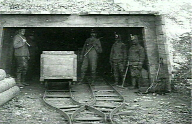
The first coal mine in Greenland operated between 1778 and 1924 in Qaarsuarsuit.
Inuit settlement
A few kilometres east of Qaarsut is the Inuit settlement Qilakitsoq. The settlement is known for the discovery in 1972 of eight mummified bodies from the Thule culture. The mummies of Qilakitsoq provided important insight into the lives of Inuit who lived 500 years ago in the Thule culture.
Infrastructure
The school and the church are housed in the same building. Additionally, the village provides essential amenities such as a shop, service center, and health station.
Education
In 2011, the school had a total of 40 students, spanning from 1st to 9th grade, but organized into just four classes. The school is part of the Greenlandic school network, known as ATTAT, and is equipped with video conference equipment for teaching purposes.
Transport
Main article: Qaarsut Airport
Qaarsut Airport, located to the northwest of the settlement, serves both Qaarsut and Uummannaq, the latter accessible only by helicopter.
Population
The population of Qaarsut has dropped by over 18 percent relative to the 2000 levels, reflecting a general trend in the region.
Gallery
File:Qaarsut and its church.jpg|Qaarsut's chapel File:Qaarsut and Uummannaq's mountain.jpg|Qaarsut and Uummannaq's mountain in the background File:Overview of Qaarsut, Greenland.jpg|Overview of Qaarsut File:Colourful houses in Qaarsut.jpg|Colourful houses File:Qaarsut's primary school.jpg|School File:Qaarsut at midnight.jpg|Qaarsut at midnight sun
References
References
- da
- "Population by Localities". Statistical Greenland.
- Beck, Hylke E. (October 23, 2023). "High-resolution (1 km) Köppen-Geiger maps for 1901–2099 based on constrained CMIP6 projections". [[Nature (journal).
- Cappelen, J. (2000). "Klimaobservationer i Grønland, 1958-99 - med klimanormaler 1961-90". [[Danish Meteorological Institute]] - [[Ministry of Transport (Denmark).
- [http://bank2.stat.gl/ Statistics Greenland] {{webarchive. link. (July 21, 2011)
This article was imported from Wikipedia and is available under the Creative Commons Attribution-ShareAlike 4.0 License. Content has been adapted to SurfDoc format. Original contributors can be found on the article history page.
Ask Mako anything about Qaarsut — get instant answers, deeper analysis, and related topics.
Research with MakoFree with your Surf account
Create a free account to save articles, ask Mako questions, and organize your research.
Sign up freeThis content may have been generated or modified by AI. CloudSurf Software LLC is not responsible for the accuracy, completeness, or reliability of AI-generated content. Always verify important information from primary sources.
Report