From Surf Wiki (app.surf) — the open knowledge base
Province of Latina
Province of Italy
Province of Italy
| Field | Value |
|---|---|
| name | Province of Latina |
| native_name | it |
| settlement_type | Province |
| image_flag | Flag of The Province of Latina.svg |
| image_shield | Provincia di Latina-Stemma.svg |
| image_map | Latina in Italy.svg |
| map_caption | Map highlighting the location of the province of Latina in Italy |
| subdivision_type | Country |
| subdivision_name | Italy |
| subdivision_type1 | Region |
| subdivision_name1 | Lazio |
| seat_type | Capital(s) |
| seat | Latina |
| parts_type | Comuni |
| parts_style | para |
| p1 | 33 |
| leader_party | IV |
| leader_title | President |
| leader_name | Gerardo Stefanelli |
| unit_pref | Metric |
| area_total_km2 | 2251 |
| population_total | 561189 |
| population_as_of | 2012 |
| population_density_km2 | auto |
| demographics_type2 | GDP |
| demographics2_footnotes | |
| demographics2_title1 | Total |
| demographics2_info1 | €12.524 billion (2015) |
| demographics2_title2 | Per capita |
| demographics2_info2 | €21,844 (2015) |
| timezone1 | CET |
| utc_offset1 | +1 |
| timezone1_DST | CEST |
| utc_offset1_DST | +2 |
| postal_code_type | Postal code |
| postal_code | 04100 |
| area_code_type | Telephone prefix |
| area_code | 0773, 06, 0771 |
| registration_plate | LT |
| blank_name_sec1 | ISTAT |
| blank_info_sec1 | 059 |
| website |
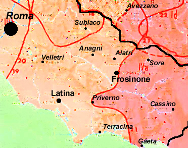
The province of Latina () is a province in the Lazio region of Italy. Its provincial capital is the city of Latina. It is bordered by the provinces of Frosinone to the northeast and by the Metropolitan City of Rome Capital to the northwest.
It has an area of 2251 km2 and a population of 561,189 (2012). The province contains comuni (: comune).
Sub-divisions of the province
Main article: Comuni of the Province of Latina
The most populous comuni are:
| Comune | Population |
|---|---|
| Latina | 128,810 |
| Aprilia | 74,691 |
| Terracina | 46,245 |
| Fondi | 39,773 |
| Formia | 38,264 |
| Cisterna di Latina | 36,742 |
| Sezze | 24,866 |
| Gaeta | 20,936 |
| Sabaudia | 20,305 |
| Minturno | 19,816 |
| Pontinia | 14,883 |
| Priverno | 14,452 |
| Cori | 11,108 |
| Itri | 10,724 |
| Sermoneta | 10,155 |
| San Felice Circeo | 10,018 |
| Sonnino | 7,548 |
| Santi Cosma e Damiano | 6,889 |
| Monte San Biagio | 6,322 |
History
The province of Latina was founded on 18 December 1934, encompassing mainly the drained areas of the Agro Pontino previously part of the province of Rome. Apart from the Pontine lands, it includes the Aurunci, Lepini and Ausoni mountain ranges, as well as the Pontine islands archipelago. The port of Gaeta and Formia, in the southernmost part of the province, belonged traditionally and linguistically to Campania.
In Bronze Age, complex permanent settlement systems and functionally differentiated societies developed in the Pontine region. This included preparation of fish and salt at the coast and metallurgy slightly inland. Late Iron Age fortified settlements evolved on the Alban hills and Monti Lepini. Small-scale farming and urbanisation developed only in or right before the Roman Age with transhumant pastoralism still continuing. From 350 BC onwards, the colonies of Cora (Cori), Norba and Setia (Sezze) were built. The small peasant economy was gradually replaced by large specialised latifundia.
Geography
Although the smallest of the provinces in the Lazio region, the province of Latina includes a variety of geographical and historical areas.
Hill and mountain areas
The mainland area is, in the south- and north-eastern part, mostly occupied by limestone hills and mountains. Ranges include the Lepini, Aurunci, Ausoni. The highest elevation is that of 1533 m Monte Petrella (Aurunci). The climate is semi-continental with hot summers and cold winters; temperatures rarely fall below 0 C.
The mountains are characterized by small medieval settlements (borghi). The people traditionally lived by cattle raising and agriculture; however, these activities have markedly declined in the 21st century. Today, workers usually commute daily to jobs in Rome or Latina.
Tourism is an increasing part of the economy, with people attracted especially by the uncontaminated natural environment and by artistic traces of the Middle Ages (Abbeys of Valvisciolo and Fossanova, where St. Thomas Aquinas died). The main centres of this area are Cori, Sezze, and Priverno.
Agro Pontino
The Agro Pontino occupies the plain extending southwards from Aprilia to Terracina, along the Tyrrhenian Sea. Until the 1930s, it was covered by marshes, considered to be unhealthy.
These were drained and land reclaimed under the Fascist government. Agriculture was expanded, and new towns built by and for workers coming from north-eastern Italy. These included Sabaudia and Latina.
The sole mountain peak is that of Circeo promontory. The climate is mild. The Agro Pontino is the most economically developed part of the province, housing a flourishing agricultural sector and numerous service firms and industries. It also houses much of the water basins of the province, such as the coast Lakes of Fogliano, Caprolace, and Paola.
Apart from the capital, the main cities include Cisterna di Latina, Terracina, and Sabaudia.
Formia and Gaeta
Cities rich of ancient and medieval history, Gaeta and Formia were traditionally part of the Kingdom of Naples. They belonged to the Campania region until 1934. Traces of the different cultural milieu can be identified in the costumes and, most of all, in the local dialect, a variant of Neapolitan. Formia and Gaeta constitutes a single metropolitan area with an important port (with connection to the Pontine Islands), a station on the main railway line Rome-Naples. Other important centres include Sperlonga and Minturno.
Pontine Islands
Main article: Pontine Islands
Once mainly used as penitentiaries, the Pontine Islands are now a renowned tourist resort in summer. The only inhabited islands are Ponza and Ventotene.
References
References
- [http://stats.oecd.org/ Regions and Cities > Regional Statistics > Regional Economy > Regional Gross Domestic Product (Small regions TL3)], OECD.Stats. Accessed on 16 November 2018.
- [https://web.archive.org/web/20070807094512/http://www.upinet.it/indicatore.asp?id_statistiche=6 Statistics of Italy]
- van Joolen, Ester. "Parco Nazionale del Circeo". University of Groningen.
- [http://www.italica.rai.it/principali/lingua/bruni/mappe/mappe/f_dialetti.htm Pellegrini's map] {{webarchive. link. (2009-10-12)
This article was imported from Wikipedia and is available under the Creative Commons Attribution-ShareAlike 4.0 License. Content has been adapted to SurfDoc format. Original contributors can be found on the article history page.
Ask Mako anything about Province of Latina — get instant answers, deeper analysis, and related topics.
Research with MakoFree with your Surf account
Create a free account to save articles, ask Mako questions, and organize your research.
Sign up freeThis content may have been generated or modified by AI. CloudSurf Software LLC is not responsible for the accuracy, completeness, or reliability of AI-generated content. Always verify important information from primary sources.
Report