From Surf Wiki (app.surf) — the open knowledge base
Prospidnick
| Field | Value |
|---|---|
| country | England |
| map_type | Cornwall |
| static_image | The Prospidnick menhir - geograph.org.uk - 526159.jpg |
| static_image_width | 240px |
| coordinates | |
| civil_parish | Sithney |
| unitary_england | Cornwall |
| lieutenancy_england | Cornwall |
| region | South West England |
Prospidnick is a small village and hill in the parish of Sithney in Cornwall, United Kingdom. It lies 0.6 miles east of Crowntown and 2.6 miles west of Wendron by road. It is divided into Lower Prospidnick and Higher Prospidnick.
History
Various spelling have been documented including Prospynneck, 1577; Prospynnecke, 1606; Prispynneck, Pryspinneck, c.1625; Prespynick, 1636; Prispidnick, 1665; Prospinnick, 1841, 1842; Prospidneck, 1884; and Prospidnick since 1996. Historically, it was known for its granite hills; and the Propidnick Wheal Mine and quarry operated in the area. In 1916, the Prospidnick Mining Company was reportedly interested in mining in Nancegollan.
Geography
Along with Prospidnick, there are several other villages in Sithney parish; these include Guavas, Mellangoose, Higher and Lower Prospidnick, Tregoose, Trevarnoe, and Truthal. The region is characterized by rock, granite, wolfram and tinstone. The easternmost of the two great granitic tracts in West Cornwall extends from Prospidnick and Nancegollan in the west to Ponsanooth and Budock to the east, and from near Polwheveral in the south to Wheal Butter to the north.
Much of Longstone Downs was turned into tillable ground in the early 1880s by Mr R G Rowe who had a 99-year lease on the higher portion of Prospidnick Hill. Some of the surrounding area was not suitable for crops, Mr Bickford-Smith planted several acres of shrubs ″ ... which, it is hoped, will in a few years tend to relieve the monotony of the present appearance of the long stretch of the Prospidnick Hills.″
Notable landmarks
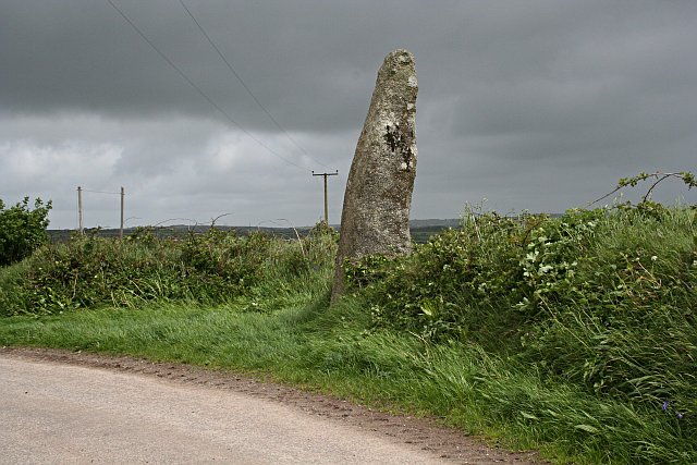
Prospidnick Manor once belonged to the Arundells, then Christopher Wallis and in 1872 was reported to be in the property of his representative C W Popham. The Prospidnick Long Stone is a 3 m high standing stone, a large granite menhir, on Longstone Down, 660 m northeast of Prospidnick Hill. There is also logan stone (the Men Amber) and an overgrown cromlech. The Cornish Heart Unit Fund has a building in the village. To the southwest there is a church called Chynhale Methodist Chapel. Some of the buildings in Prospidnick are cottages dated to the 18th century with thatched roofs.
Another landmark in Prospidnick is the Prospidnick Arch, a railway bridge that is part of the local Helston Railway. It is reported to be 40 feet (12 m) high and cost £1,000 in the early 1880s.
References
References
- Treloar, Orson Lee. (1962). "Treloar genealogy: tree of Treloar". Paragon Press.
- Lysons, Samuel. (1814). "Magna Britannia: being a concise topographical account of the several counties of Great Britain. Containing Cornwall". Cadell.
- (2009). "Ordnance Survey: Landranger map sheet 203 ''Land's End & Isles of Scilly (St Ives & Lizard Point)''". Ordnance Survey.
- (1878). "Book of reference to the plan of the parish of Sithney (hundred of Kerrier), in the county of Cornwall, containing 5826.035 acres". Printed by Eyre and Spottiswoode, for Her Majesty's Stationery Office.
- Bond, Chris . (3 Sep 2011). "Prospidnick".
- Francis, Henry. (September 1868). "Mineral Phenomena". The Royal Cornwall Polytechnic Society.
- Rundle, S.. (August 1886). "The Antiquary's Note-Book : Antiquities of Godolphin, Cornwall : Remarkable Rocks, etc. : I". Elliot Stock .
- (February 19, 1916). "The occurrence and output of tungsten ores in Great Britain". The Mining Journal: (Railway & Commercial Gazette).
- "Magic Map Application". Defra.
- (1824). "The history of Cornwall: from the earliest records and traditions, to the present time". William Penaluna.
- Spargo, Thomas. (1865). "The mines of Cornwall and Devon; statistics and observations". Emily Faithfull.
- (1907). "The geology of the Land's End district". Printed for H.M. Stationery Off., by Wyman & Sons.
- Henwood, William Jory. (1873). "Observations on the detrital tin-ore of Cornwall". Netherton.
- (1 June 1882). "Improving Longstone Downs". The Cornishman.
- Polsue, Joseph. (1872). "A complete parochial history of the county of Cornwall: compiled from the best authorities & corrected and improved from actual survey ; illustrated". W. Lake.
- "Prospidnick Menhir". Megalithic.co.uk.
- Wade, Joseph Henry. (1928). "Rambles in Cornwall". Methuen & Co., ltd..
- (11 January 1883). "Inspection Of The Helston Railway Works". The Cornishman.
This article was imported from Wikipedia and is available under the Creative Commons Attribution-ShareAlike 4.0 License. Content has been adapted to SurfDoc format. Original contributors can be found on the article history page.
Ask Mako anything about Prospidnick — get instant answers, deeper analysis, and related topics.
Research with MakoFree with your Surf account
Create a free account to save articles, ask Mako questions, and organize your research.
Sign up freeThis content may have been generated or modified by AI. CloudSurf Software LLC is not responsible for the accuracy, completeness, or reliability of AI-generated content. Always verify important information from primary sources.
Report