From Surf Wiki (app.surf) — the open knowledge base
Prince George's County, Maryland
County in Maryland, United States

County in Maryland, United States
| Field | Value |
|---|---|
| county | Prince George's County |
| official_name | Prince George's County, Maryland |
| state | Maryland |
| type | County |
| ex image | {{Photomontage |
| photo1a | GaylordNationalResortFromRiver.jpg |
| photo2a | National Harbor (3415458249).jpg |
| photo2b | Mckeldin Mall.jpg |
| photo4a | Fort Washington Park, Fort Washington, Maryland (14496625334).jpg |
| photo4b | Greenbelt Park, Greenbelt, Maryland 001.JPG |
| spacing | 2 |
| position | center |
| color_border | white |
| color | white |
| size | 270 |
| foot_montage | Clockwise: Gaylord National Resort & Convention Center, McKeldin Mall at University of Maryland, College Park, Greenbelt Park, Fort Washington Park, National Harbor. |
| flag | Flag of Prince George's County, Maryland.svg |
| seal | Seal of Prince George's County, Maryland.svg |
| logo | Logo of Prince George's County, Maryland.png |
| nicknames | "PG County", "P.G." |
| motto | "Semper Eadem" () |
| demonym | Prince Georgian |
| ZIP codes | 20607–20774 |
| area codes | 240, 301 |
| founded date | April 23 |
| founded year | 1696 |
| named for | Prince George of Denmark |
| leader_title | Executive |
| leader_name | Aisha Braveboy |
| seat wl | Upper Marlboro |
| largest city wl | Bowie |
| area_total_sq_mi | 499 |
| area_land_sq_mi | 483 |
| area_water_sq_mi | 16 |
| area percentage | 3.2 |
| pop | 966629 |
| pop_est_as_of | 2024 |
| population_est | 966,629 |
| density_sq_mi | 1900 |
| district | 4th |
| district2 | 5th |
| district3 | 8th |
| time zone | Eastern |
| website |
Prince George's County (often shortened to PG County, PG, or PGC) making it the second-most populous county in Maryland, behind neighboring Montgomery County. The 2020 census counted an increase of nearly 104,000 in the previous ten years. Its county seat is Upper Marlboro. It is the most populous African American-majority county in the United States, as well as the second most affluent behind neighboring Charles County.
The county is part of the Capital region of the state, though portions of the county are considered to be in Southern Maryland. The county also hosts many federal governmental facilities, such as Joint Base Andrews and the United States Census Bureau headquarters.
Etymology
The official name of the county, as specified in the county's charter, is "Prince George's County, Maryland". The county is named after Prince George of Denmark (1653–1708), the consort of Anne, Queen of Great Britain, and the brother of King Christian V of Denmark and Norway. The county's demonym is Prince Georgian, and its motto is Semper Eadem (), a phrase used by Queen Anne. Prince George's County is frequently referred to as "PG" or "PG County", an abbreviation which is the subject of debate, some residents viewing it as a pejorative and others holding neutral feelings toward the term or even preferring the abbreviation over the full name.
History
The Cretaceous Era brought dinosaurs to the area that left fossils now preserved in a 7.5 acre park in Laurel. The site, which among other finds has yielded fossilized teeth from Astrodon and Priconodon species, has been called the most prolific in the eastern United States.
In the mid to late Holocene era, the area was occupied by Paleo-Native Americans and then, later, Native Americans. When the first European settlers arrived, what is now Prince George's County was inhabited by people of the Piscataway Indian Nation. Three branches of the tribe are still living today, two of which are headquartered in Prince George's County.
17th century
Prince George's County was created by the English Council of Maryland in the Province of Maryland in April 1696 from portions of Charles and Calvert counties. The county was divided into six districts referred to as "Hundreds": Mattapany, Petuxant, Collington, Mount Calvert, Piscattoway and New Scotland.{{cite web |access-date=May 4, 2007 |archive-url=https://web.archive.org/web/20070928075931/http://aomol.net/megafile/msa/speccol/sc2900/sc2908/000001/000023/html/am23--23.html |archive-date=September 28, 2007
18th century
A portion was detached in 1748 to form Frederick County. Because Frederick County was subsequently divided to form the present Allegany, Garrett, Montgomery, and Washington counties, all of these counties in addition were derived from what had up to 1748 been Prince George's County.
In 1791, portions of Prince George's County were ceded to form the new District of Columbia (along with portions of Montgomery County, Maryland and parts of Northern Virginia that were later returned to Virginia).
19th century
During the War of 1812, the British marched through the county by way of Bladensburg to burn the White House. On their return, they kidnapped a prominent doctor, William Beanes. Lawyer Francis Scott Key was asked to negotiate for his release, which resulted in his writing "The Star-Spangled Banner".
Prince George's County had the highest population of enslaved Africans within the state of Maryland. These people carried out forced labor on tobacco farms and plantations throughout Prince George's County.
During the Civil War, hundreds of enslaved black men in Prince George's County were given freedom in exchange for joining the Union Army and fighting in Colored units against Confederate forces. When Abraham Lincoln ordered the end of slavery in America, he did not free the slaves in Maryland because he was concerned that slave-owning Maryland would revolt, leaving Washington D.C. surrounded by Confederate forces. However John Pendleton Kennedy, a Maryland politician who became an abolitionist after watching a speech by Frederick Douglass, led a referendum campaign to end slavery in the state. In 1864, the citizens of Maryland voted to end slavery. However the state was so divided that the referendum won by only 1,000 votes. Lincoln then ordered the Union Army to enforce the ban in Maryland and all enslaved people in the state were freed.
After the Civil War, many African Americans attempted to become part of Maryland politics, but were met with violent repression after the fall of Reconstruction.
In April 1865, John Wilkes Booth made his escape through Prince George's County while en route to Virginia after killing President Abraham Lincoln.
20th century
The proportion of African Americans declined during the first half of the 20th century, but was renewed to over 50% in the early 1990s when the county again became majority African American. The first African American County Executive was Wayne K. Curry, elected in 1994.
On July 1, 1997, the Prince George's County section of the city of Takoma Park, which straddled the boundary between Prince George's and Montgomery counties, was transferred to Montgomery County. This was done after city residents voted in a referendum to be under the sole jurisdiction of Montgomery County, and subsequent approval by both counties and the Maryland General Assembly. This was the first change in Montgomery/Prince George's County line boundaries since 1968, when the City of Laurel was unified in Prince George's County; additional legislation was proposed in 1990 for a technical correction, though may not have achieved enactment.
21st century
The county's population nearly reached one million residents in the 2020 census. Hispanic residents grew in number to 21% of the total population.
The county experienced a dramatic drop in crime, including record drops in violent crime, although in 2021 and 2022, violent crime increased by 30%. From 2020 to mid-2022 over 2,200 residents died of COVID-19, over 19,000 county residents were left with long-term post-COVID symptoms and over 193,000 COVID infections had been recorded.
Geography
According to the U.S. Census Bureau, the county has a total area of 499 sqmi, of which 483 sqmi is land and 16 sqmi (3.2%) is water.
Prince George's County lies in the Atlantic coastal plain, and its landscape is characterized by gently rolling hills and valleys. Along its western border with Montgomery County, Adelphi, Calverton and West Laurel rise into the piedmont, exceeding 300 ft in elevation.
The Patuxent River forms the county's eastern border with Howard, Anne Arundel, Charles and Calvert counties.
Regions
= North County
= Central County
= Rural Tier
= Inner Beltway
= South County ]] Terrain, culture, and demographics differ significantly by location within the county. There are five key regions to Prince George's County: North County, Central County, the Rural Tier, the Inner Beltway, and South County. These regions are not formally defined, however, and the terms used to describe each area can vary greatly. In the broadest terms, the county is generally divided into North County and South County with U.S. Route 50 serving as the dividing line.
Southern Prince George's County is also considered to be a part of the Southern Maryland region.
North County
Northern Prince George's County includes Laurel, Beltsville, Adelphi, College Park and Greenbelt. This area of the county is anchored by the Capital Beltway and the Baltimore–Washington Parkway. Hyattsville developed early in the 20th century due to its proximity to rail transportation and U.S. Highway 1. Laurel is experiencing a population boom with the construction of the Inter-County Connector. The key employers in this region are the University of Maryland, Beltsville Agricultural Research Center, and NASA-Goddard Space Flight Center. Areas of geographic distinction include Greenbelt Park, a wooded reserve adjacent to the planned environmental community of Greenbelt, and University Park, a collection of historic homes adjacent to the University of Maryland. Riversdale Mansion, along with the historic homes of Berwyn Heights, Mt. Rainier and Hyattsville, along with Langley Park are also located in this area. Lake Artemesia and the surrounding park were constructed during the completion of the Washington Metro Green Line, and it incorporates a stocked fishing lake and serves as the trail-head for an extensive Anacostia Tributary Trails system that runs along the Anacostia River and its tributaries. The south and central tracts of the Patuxent Wildlife Research Center also lie in this part of the county; the north tract lies north of the Patuxent River in Anne Arundel County.
Central County
Central County, located on the eastern outskirts of the Capital Beltway, consists of Mitchellville, Woodmore, Greater Upper Marlboro, Springdale, Largo, and Bowie. According to the 2010 census, it has generally been the fastest growing region of the county. Mitchellville is named for a wealthy family, the Mitchells, who owned a large portion of land in this area of the county. Central Avenue, a major exit off the I-95 beltway, running east to west, is one of two main roads in this portion of the county. The other major roadway is Old Crain Highway, which runs north to south along the eastern portion of the county. The Newton White Mansion on the grounds is a popular site for weddings and political events. Joint Base Andrews, Bowie State University and Prince George's Community College are in the Central region, as well as County government offices.
Inner Beltway
The inner beltway communities of Capitol Heights, District Heights, Fairmont Heights, Forestville, Suitland, Hillcrest Heights, Oxon Hill, and Seat Pleasant border neighboring District of Columbia's northeastern and southeastern quadrants. The area has easy access to Metro's Blue, Silver or Green Lines, commercial centers, Maryland Route 214, and Interstate 95/Interstate 495 (Capital Beltway). Protected bike trails connect residents to the Bladensburg waterfront, Kenilworth parks, and downtown D.C. Fairmont Heights is the second oldest African-American-majority municipality in Prince George's County. The Fairmount Heights Historic District was added to the National Register of Historic Places in 2011.
Bowie is best known as a planned Levittown. William Levitt in the 1960s built traditional homes, as well as California contemporaries along U.S. Route 50, the key highway to the eastern shore and the state capital of Annapolis. Bowie has currently grown to be the largest city in Prince George's County, with more than 50,000 people. It also has a large Caucasian population, compared to much of the county (48% of the population). Housing styles vary from the most contemporary to century-old homes in Bowie's antique district (formerly known as Huntingtown), where the town of Bowie began as a haven for thoroughbred horse racing. Areas of geographic distinction include the Oden Bowie Mansion, Allen Pond, key segments of the Washington, Baltimore and Annapolis Trail, as well as planned parks, lakes and walking trails.
Rural Tier
Prince George's rural tier was designated "in the 2002 General Plan as an area where residential growth would be minimal"; it may be found in the area just beyond the Beltway to the west and south of central county, though with direct access by Route 210, while bounded on the west by the communities Accokeek and Fort Washington, and the east by the Patuxent River. Prince George's origins are in this part of the county. Most of this area contains the unincorporated parishes, villages and lost towns of Prince George's County. Largely under postal designations of "Upper Marlboro" or "Brandywine", in truth the town of Upper Marlboro is more central county in character, though it is the post office location for various rural settlements. (The names of these unincorporated areas are listed below in the towns section of this article). Since 1721 Upper Marlboro has been the county seat of government, with families that trace their lineage back to Prince George's initial land grants and earliest governing officials. Names like Clagett, Sasscer, King James and Queen Anne pepper the streets.
The rural tier has been the focus of orchestrated efforts by residents and county government to preserve its rural character and environmental integrity. Under the Maryland-National Capital Park and Planning Commission (M-NCPPC), Patuxent River Park is the largest natural preserve and provides public access for birdwatching and viewing the rural tier's natural waterfront vistas. In season, the park's Jug Bay Natural Area and the Patuxent Riverkeeper in Queen Anne both offer canoeing and kayaking rentals on the Patuxent. The county's largest collection of tobacco planter mansions and preserved homes are in the rural tier, some managed by the M-NCPPC. Many rural tier roads have scenic highway preservation status. Rosaryville State Park is in the county, not far from the county seat.
South County
South County is a blend of the greenery of the rural tier and the new development of central county. The communities of Clinton, Oxon Hill, Temple Hills including Hillcrest Heights, and Fort Washington are the largest areas of south county. It is the only portion of Prince George's County to enjoy the Potomac River waterfront, and that geographic distinction has yielded the rise of the National Harbor project: a town center and riverside shopping and living development on the Potomac. The National Harbor, and its associated entertainment (MGM National Harbor) and shopping (Tanger Outlets) districts, have become a major tourist and convention attraction, with significant hotel accommodations, eateries and shopping. Together, these projects were built on land formerly occupied by the Salubria plantation, where a 14-year-old slave girl poisoned her owner, John H. Bayne, and his family in 1831. Water taxi service connects National Harbor to other destinations along the Potomac. Several historic sites, including Jones Point Lighthouse, can be viewed from the harbor front. Piscataway Park in Accokeek preserves many acres of woodland and wetlands along the Potomac River opposite Mount Vernon, Virginia. River Road in Fort Washington also yields great views of the Potomac. Fort Washington Park was a major battery and gives access to the public for tours of the fort, scenic access to the river and other picnic grounds. Oxon Hill Manor offers a working farm and plantation mansion for touring; His Lordship's Kindness is another major historic home. Also, Fort Foote is an old American Civil War fort and tourist destination.
Adjacent counties and independent cities
- Anne Arundel County (east)
- Calvert County (southeast)
- Charles County (south)
- Howard County (north)
- Montgomery County (northwest)
- Fairfax County, Virginia (southwest)
- Alexandria, Virginia (southwest)
- Washington, D.C. (west)
Prince George's and Montgomery Counties share a bi-county planning and parks agency in the M-NCPPC and a public bi-county water and sewer utility in the Washington Suburban Sanitary Commission
National protected areas
- Fort Washington Park
- Greenbelt Park
- Patuxent Wildlife Research Refuge (part)
- Piscataway Park
- Cedarville State Forest (whose main entrance is in Prince George's County)
Politics and government
Since 1792, the county seat has been Upper Marlboro. Prior to 1792, the county seat was located at Mount Calvert, a 76-acre (308,000 m2) estate along the Patuxent River on the edge of what is now in the unincorporated community of Croom. Since 1991, the county has slowly moved government functions from rural Upper Marlboro to the Largo area, closer to the center of population, while proposals to move the actual county seat remain controversial.
Prince George's County was granted a charter form of government in 1970 with the county executive elected as the head of the executive branch and the county council members as the leadership of the legislative branch. The county is divided into nine councilmanic districts, whose number designations wind roughly from north to south. Two at-large council seats were added in 2018. Prince George's County is part of the Seventh Judicial Circuit of the state of Maryland and holds 23 of the 32 total circuit court judges in the circuit (which includes Calvert, Charles, Prince George's, and St. Mary's counties).
Fitch Ratings assigned a 'AAA' bond rating to Prince George's County on August 25, 2011, re-affirming the county's stable financial outlook. Earlier in 2011, the county received 'AAA' status from Standard & Poor's and Moody's. 'AAA' bond ratings are the highest possible bond ratings a jurisdiction can receive.
As part of the increasingly liberal D.C. suburbs and a nationwide suburban shift towards the Democrats, Prince George's County is a Democratic stronghold, having voted majority-Democratic in every presidential election but four since 1932: Dwight D. Eisenhower's landslide elections in 1952 and 1956, and Richard Nixon's two candidacies in 1968 and 1972. It has not given over 15% of the vote to the Republican nominee since 2004, and was Joe Biden's second strongest county in the country (and third-best county equivalent after Washington, D.C.) in the 2020 presidential election, only behind Kalawao County, Hawaii, awarding him 89.26% of the vote, and Kamala Harris's strongest county (again, after Washington DC) in the 2024 presidential election, awarding her 85.9% of the vote.
Voter registration
| Voter registration and party enrollment as of March 2024 | Total |
|---|---|
| Democratic | |
| Unaffiliated | |
| Republican | |
| Libertarian | |
| Other parties |
|}
County executive and council
| Name | Party | Term | ||
|---|---|---|---|---|
| William W. Gullett | ||||
| Win Kelly | ||||
| Lawrence Hogan | ||||
| Parris Glendening | ||||
| Wayne K. Curry | ||||
| Jack B. Johnson | ||||
| Rushern L. Baker III | ||||
| Angela D. Alsobrooks | ||||
| Tara Jackson (acting) | ||||
| Aisha Braveboy |
| Name | Party | District | ||
|---|---|---|---|---|
| Tom Dernoga | ||||
| Wanika Fisher | ||||
| Eric Olson | ||||
| Vacant | ||||
| Shayla Adams-Stafford | ||||
| Danielle Hunter | ||||
| Krystal Oriadha (Vice Chair) | ||||
| Edward Burroughs III (Chair) | ||||
| Sydney Harrison | ||||
| Jolene Ivey | ||||
| Wala Blegay |
Other officials
- State's Attorney: Tara Jackson (acting) (D)
- County Sheriff: John D. B. Carr (D)
- County Fire Chief: Tiffany D. Green
- Clerk of the Circuit Court: Mahasin El Amin
- Chief of the County Police: Malik Aziz
- PGCPS Chief Executive Officer: Monica Goldson
Emergency services
Law enforcement

Prince George's County is serviced by multiple law enforcement agencies. The Prince George's County Police Department is the primary police service for county residents residing in unincorporated areas of the county. In addition, the Prince George's County Sheriff's Office acts as the enforcement arm of the county court, and also shares some patrol responsibility with the county police. County parks are serviced by the Prince George's County Division of the Maryland-National Capital Park Police. Besides the county-level services, all but one of the 27 local municipalities maintain police departments that share jurisdiction with the county police services. Furthermore, the Maryland State Police enforces the law on state highways which pass through the county with the exception of Maryland Route 200 where the Maryland Transportation Authority Police is the primary law enforcement agency and the Maryland Department of Natural Resources Police patrol the state parks and navigable waterways located within the county.
Along with the state and local law enforcement agencies, the federal government also maintains several departments that service citizens of the county such as the US Park Police, US Postal Police, the 316th Security Forces Squadron (specifically covering Andrews AFB), and other federal police located on various federal property within the county.

In addition, nearly all of the incorporated cities and towns in the county have their own municipal police force. Notable exceptions include the city of College Park.
Other emergency services
Prince George's County hospitals include Bowie Health Center, Doctors Community Hospital in Lanham, Gladys Spellman Specialty Hospital & Nursing Center in Cheverly, Laurel Regional Hospital in Laurel, Southern Maryland Hospital Center in Clinton, University of Maryland Capital Region Medical Center, a state-of-the-art acute care teaching hospital, and Fort Washington Medical Center. Hospice of the Chesapeake has offices in Largo, with a staff that serves patients in their homes, including skilled nursing, senior living and assisted living facilities.
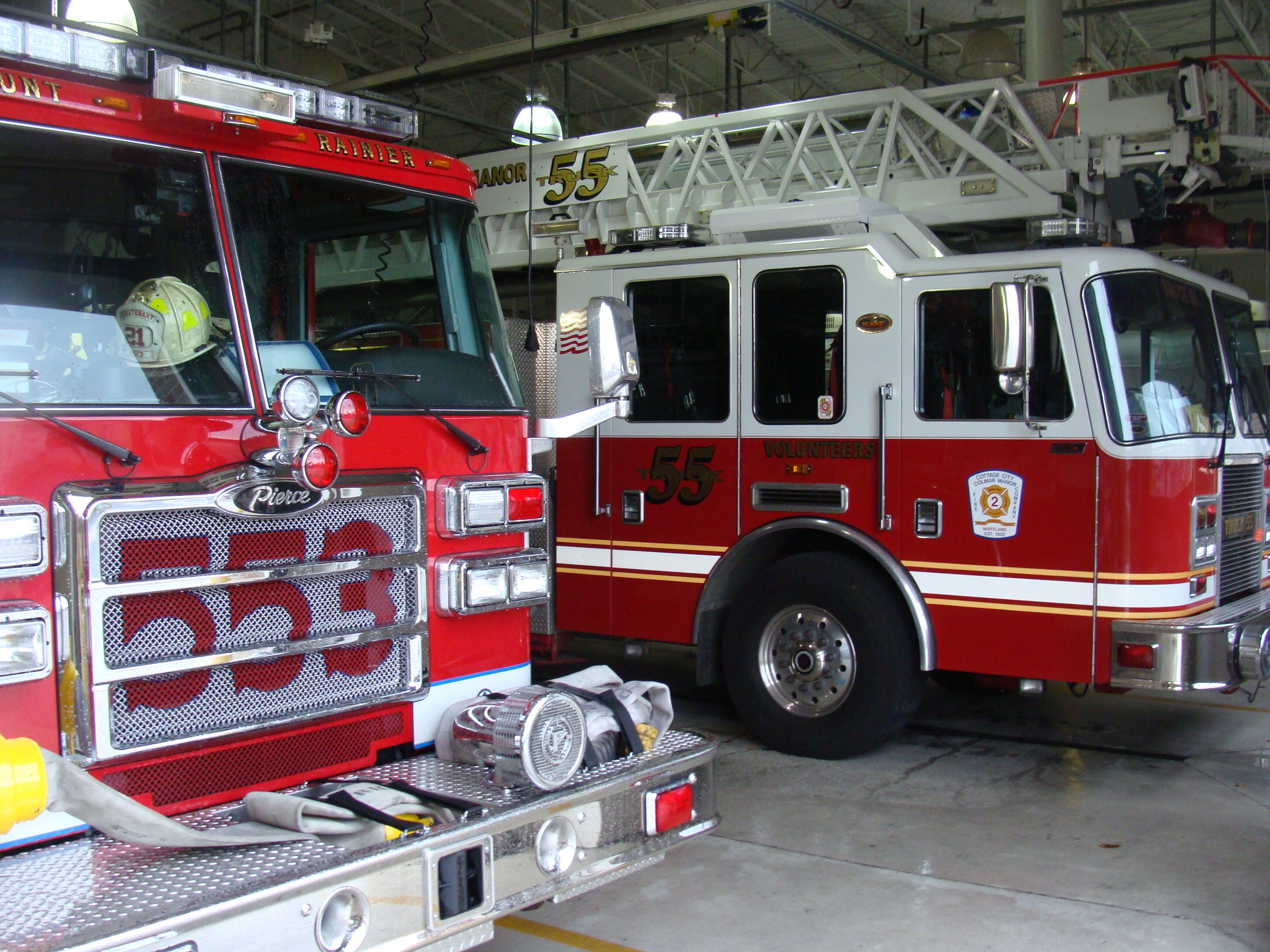
The Prince George's County Volunteer Firemen's Association was formed in 1922 with several of the first companies organized in the county. The first members of the association were Hyattsville, Cottage City, Mount Rainier, and Brentwood.
In March 1966, the Prince George's County Government employed the firefighters who had been hired by individual volunteer stations and an organized career department was begun. The career firefighters and paramedics are represented by IAFF 1619. Prince George's County Fire/Rescue Operations consists of 45 Fire/EMS stations.
Prince George's County became the first jurisdiction in Maryland to implement the 9-1-1 Emergency Reporting System in 1973. Advanced life support services began for citizens of the county in 1977. Firefighters were certified as Cardiac Rescue Technicians and deployed in what was called at the time Mobile Intensive Care Units to fire stations in Brentwood, Silver Hill, and Laurel.
As of 2007, the Prince George's County Fire/EMS Department operates a combination system staffed by over 800 career firefighters and paramedics, and nearly 1,100 active volunteers.
County law has, for years, required Animal Control to seize all pit bulls from their owners if they become aware of them. This is controversial and Animal Control itself objects to this law. It has routinely required them to act when they see such a dog behaving peacefully inside of a private home merely because Animal Control is checking something unrelated.
State representation
The Prince George's County Delegation represents the county via 23 delegates in the Maryland House of Delegates, including Joseline Peña-Melnyk, the speaker of the Maryland House of Delegates. Eight senators represent the county in the Maryland State Senate.
House of Delegates
| District | Counties represented | Delegate | Party | First elected | Committee | ||
|---|---|---|---|---|---|---|---|
| 21 | Anne Arundel, Prince George's | [[File:Mary A. Lehman (53177691998).jpg | 20px]] | Mary A. Lehman | Democratic | 2018 | |
| 21 | Anne Arundel, Prince George's | [[File:Benjamin S. Barnes (2007).jpg | 20px]] | Democratic | 2006 | ||
| 21 | Anne Arundel, Prince George's | [[File:Joseline Peña-Melnyk (2007).jpg | 20px]] | Democratic | 2006 | ||
| 22 | Prince George's | [[File:Ashanti Martinez Feb2023.jpg | 20px]] | Democratic | 2023 (appointed) | ||
| 22 | Prince George's | [[File:Anne Healey (2007).jpg | 20px]] | Democratic | 1990 | ||
| 22 | Prince George's | [[File:NicoleWilliams-2 crop.jpg | 20px]] | Democratic | 2019 (appointed) | ||
| 23 | Prince George's | [[File:Adrian Boafo Feb2023.jpg | 20px]] | Democratic | 2022 | ||
| 23 | Prince George's | [[File:Kym Taylor 53597343506 (cropped).jpg | 20px]] | Democratic | 2022 | ||
| 23 | Prince George's | [[File:Marvin E. Holmes, Jr. (2007).jpg | 20px]] | Democratic | 2002 | ||
| 24 | Prince George's | [[File:Andrea Harrison 10025252574 (cropped).jpg | 20px]] | Democratic | 2018 | ||
| 24 | Prince George's | [[File:1tiffany alston.jpg | 20px]] | Democratic | 2022 | ||
| 24 | Prince George's | Democratic | 2026 (appointed) | ||||
| 25 | Prince George's | [[File:Kent Roberson (53517515269).jpg | 20px]] | Democratic | 2023 (appointed) | ||
| 25 | Prince George's | [[File:Deniise Roberts (53516986249).jpg | 20px]] | Democratic | 2024 (appointed) | ||
| 25 | Prince George's | [[File:Delegate Karen Toles.jpg | 20px]] | Democratic | 2022 (appointed) | ||
| 26 | Prince George's | [[File:Kris Valderrama (2007).jpg | 20px]] | Democratic | 2006 | ||
| 26 | Prince George's | [[File:Delegate Jamila Woods Feb2023.jpg | 20px]] | Democratic | 2022 | ||
| 26 | Prince George's | [[File:Veronica L. Turner (2007).jpg | 20px]] | Democratic | 2018 | ||
| Charles, Prince George's | Democratic | 2026 (appointed) | |||||
| Calvert, Prince George's | [[File:Legislative Black Caucus Breakfast (52692281612) (cropped).jpg | 20px]] | Democratic | 2022 | |||
| Prince George's | [[File:Delegate Diana Fennell.jpg | 20px]] | Democratic | 2014 | |||
| Prince George's | [[File:Delegate ivey prince george's county.jpg | 20px]] | Democratic | 2018 | |||
| Prince George's | [[File:Legislative Black Caucus Breakfast (52692800861) (cropped).jpg | 20px]] | Democratic | 2022 |
State Senate
| District | Senator | Party | Since | Residence | Counties represented | |
|---|---|---|---|---|---|---|
| 21 | Democratic | 2007 | College Park | Anne Arundel, Prince George's | ||
| 22 | Alonzo T. Washington | Democratic | 2023 | Greenbelt | Prince George's | |
| 23 | Democratic | 2021 | Upper Marlboro | Prince George's | ||
| 24 | Democratic | 2011 | Landover | Prince George's | ||
| 25 | Democratic | 2023 | Forestville | Prince George's | ||
| 26 | C. Anthony Muse | Democratic | 2023 | Accokeek | Prince George's | |
| 27 | Democratic | 2021 | Brandywine | Calvert, Charles, Prince George's | ||
| 47 | Malcolm Augustine | Democratic | 2019 | Cheverly | Prince George's |
Federal representation
In the 118th Congress, most of Prince George's County is represented in the U.S. House of Representatives by Glenn Ivey (D) of the 4th district and Steny Hoyer (D) of the 5th district. A small part of the northwestern portion of the county is represented by Jamie Raskin (D) of the 8th district.
Transportation
_from_the_pedestrian_overpass_for_the_Woodrow_Wilson_Bridge_Trail_in_National_Harbor,_Prince_George's_County,_Maryland.jpg)
The County contains a 28-mile portion of the 65-mile-long Capital Beltway. After a decades-long debate, an east–west toll freeway, the Intercounty Connector ("ICC"), which extends Interstate 370 in Montgomery County to connect I-270 with Interstate 95 and U.S. 1 in Laurel, opened in 2012. An 11.5-mile portion of the 32.5-mile-long Baltimore–Washington Parkway runs from the county's border with Washington, D.C., to its border with Anne Arundel County near Laurel.
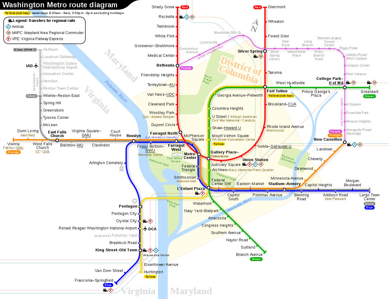
The Washington Metropolitan Area Transit Authority operates Metrobus fixed-route bus service and Metrorail heavy-rail passenger service in and out of the county as well as the regional MetroAccess paratransit system for the handicapped. The Prince George's County Department of Public Works and Transportation also operates TheBus, a County-wide fixed-route bus system, and the Call-A-Bus service for passengers who do not have access to or have difficulty using fixed-route bus service. Call-A-Bus is a demand-response service which generally requires 14-days advance reservations. The county also offers a subsidized taxicab service for elderly and disabled residents called Call-A-Cab in which eligible customers who sign up for the service purchase coupons giving them a 50 percent discount with participating taxicab companies in Prince George's and Montgomery Counties.
Mass transit

Prince George's County Metro Rail
Washington Metropolitan Area Transit Authority has fifteen stations of the Washington Metro system located in Prince George's County, with four of them as terminus stations: , , Largo, and . The Purple Line, which would link highly developed areas of both Montgomery and Prince George's Counties is currently under-construction and slated to open in 2027. The Purple Line will provide connections to the Washington Metropolitan Area Transit Authority's Red Line via Northern Prince George's County and Montgomery County. The Orange Line and MARC Train's Penn Line will have transfer points at New Carrollton.
Prince George's County Commuter Rail
The MARC Train (Maryland Area Rail Commuter) train service has two lines that traverse Prince George's County. The Camden Line, which runs between Baltimore Camden Station and Washington Union Station and has six stops in the county at Riverdale, College Park, Greenbelt, Muirkirk, Laurel and Laurel Race Track. The Penn Line runs on the Amtrak route between Pennsylvania and Washington Union stations. It has three stops in the county: Bowie State, Seabrook and New Carrollton.
Airports
The College Park Airport (CGS), established in 1909, is the world's oldest continuously operated airport and is home to the adjacent College Park Aviation Museum.
Privately owned general aviation airfields in the county include Freeway Airport (W00) in Mitchellville, Potomac Airfield (VKX) in Friendly, and private heliports.
The area is served by three airports: Ronald Reagan Washington National Airport (DCA) in Arlington County, Virginia, Baltimore–Washington International Thurgood Marshall Airport (BWI) in neighboring Anne Arundel County, and Dulles International Airport (IAD) in Dulles, Virginia.
Andrews Air Force Base (ADW), the airfield portion of Joint Base Andrews, is also near Camp Springs.
Water taxi
Prince George's County is served by a water taxi that operates from the National Harbor to Alexandria, Virginia and to The Wharf in Washington, D.C.
Major highways
Future transit
Because of its location north and east of Washington, D.C., several future transit technology projects look to be routed partially through Prince George's County. The first stage of The Boring Company's proposed Washington-to-New York hyperloop will travel beneath the Baltimore–Washington Parkway through Prince George's en route to Baltimore. No hyperloop stops within the county are projected. Similarly, former Maryland Governor Larry Hogan has supported efforts to trial a 40-mile superconducting maglev (SCMaglev) train route connecting Washington to Baltimore. Proposed routes would run through Prince George's parallel to the Baltimore–Washington Parkway or along the Amtrak Penn Line corridor. As with the hyperloop, no SCMaglev stop is planned within Prince George's County. The Purple Line light transit rail is currently in construction in College Park and New Carrollton.
Demographics
|align-fn=center 1790–1960 1900–1990 1990–2000 2010–2020
2020 census
As of the 2020 census, the county had a population of 967,201, a median age of 36.7 years, and 21.8% of residents under the age of 18 versus 13.7% aged 65 or older. For every 100 females there were 90.7 males overall and 87.3 males for every 100 females age 18 and over. 97.6% of residents lived in urban areas while 2.4% lived in rural areas.
The racial makeup of the county was 12.9% White, 59.8% Black or African American, 0.9% American Indian and Alaska Native, 4.3% Asian, 0.1% Native Hawaiian or Pacific Islander, 14.4% from some other race, and 7.5% from two or more races, while Hispanic or Latino residents of any race comprised 21.2% of the population. The Hispanic population continues to grow, with several cities and CDPs reaching a Latino majority (Adelphi, Brentwood, Chillum, Colmar Manor, East Riverdale, Langley Park, Landover Hills, and Woodlawn).
There were 342,216 households in the county, of which 32.8% had children under the age of 18 living with them and 36.5% had a female householder with no spouse or partner present. About 27.8% of all households were made up of individuals and 8.9% had someone living alone who was 65 years of age or older.
There were 359,957 housing units, of which 4.9% were vacant. Among occupied housing units, 59.9% were owner-occupied and 40.1% were renter-occupied. The homeowner vacancy rate was 1.2% and the rental vacancy rate was 5.8%.
Racial and ethnic composition
| Race / Ethnicity (NH = Non-Hispanic) | title= 1980 Census of Population - General Population Characteristics - Table 16. Total Persons and Spanish Origin Persons by Type of Spanish Origin and Race: 1980 - Maryland | url=https://www2.census.gov/prod2/decennial/documents/1980a_mdABC-02.pdf | website=United States Census Bureau}} | title= 1990 Census of Population - General Population Characteristics - Table 6. Race and Hispanic Origin: 1990 - Maryland | url=https://www2.census.gov/library/publications/decennial/1990/cp-1/cp-1-22.pdf | website=United States Census Bureau}} | title=P004: Hispanic or Latino, and Not Hispanic or Latino by Race – 2000: DEC Summary File 1 – Prince George's County, Maryland | url=https://data.census.gov/table?g=050XX00US24033&tid=DECENNIALSF12000.P004 | website=United States Census Bureau }} | title=P2: Hispanic or Latino, and Not Hispanic or Latino by Race – 2010: DEC Redistricting Data (PL 94-171) – Prince George's County, Maryland | url=https://data.census.gov/cedsci/table?q=p2&g=050XX00US24033&tid=DECENNIALPL2010.P2 | website=United States Census Bureau }} | Pop 2020 | % 1980 | % 1990 | % 2000 | % 2010 | % 2020 |
|---|---|---|---|---|---|---|---|---|---|---|---|---|---|---|---|---|---|---|
| White alone (NH) | 383,215 | 303,090 | 194,836 | 128,853 | 109,060 | 57.62% | 41.56% | 24.31% | 14.92% | 11.28% | ||||||||
| Black or African American alone (NH) | 246,084 | 365,705 | 498,301 | 548,439 | 571,866 | 37.00% | 50.15% | 62.17% | 63.52% | 59.13% | ||||||||
| Native American or Alaska Native alone (NH) | 1,685 | 2,172 | 2,274 | 2,156 | 1,887 | 0.25% | 0.30% | 0.28% | 0.25% | 0.20% | ||||||||
| Asian alone (NH) | 16,515 | 27,344 | 30,803 | 34,815 | 41,436 | 2.48% | 3.75% | 3.84% | 4.03% | 4.28% | ||||||||
| Native Hawaiian or Pacific Islander alone (NH) | x | x | 318 | 330 | 335 | x | x | 0.04% | 0.04% | 0.03% | ||||||||
| Other race alone (NH) | 3,151 | 974 | 1,706 | 2,167 | 5,746 | 0.47% | 0.13% | 0.21% | 0.25% | 0.59% | ||||||||
| Mixed race or Multiracial (NH) | x | x | 16,220 | 17,688 | 31,408 | x | x | 2.02% | 2.05% | 3.25% | ||||||||
| Hispanic or Latino (any race) | 14,421 | 29,983 | 57,057 | 128,972 | 205,463 | 2.17% | 4.11% | 7.12% | 14.94% | 21.24% | ||||||||
| Total | 665,071 | 729,268 | 801,515 | 863,420 | 967,201 | 100.00% | 100.00% | 100.00% | 100.00% | 100.00% |
| Majority Asian |
|---|
| Place | Designation | Total Population | White alone (NH) | % | Black or | |||||||||||||||
|---|---|---|---|---|---|---|---|---|---|---|---|---|---|---|---|---|---|---|---|---|
| African American alone (NH) | % | Native American or | ||||||||||||||||||
| Alaska Native alone (NH) | % | Asian alone (NH) | % | Pacific Islander alone (NH) | % | Other race alone (NH) | % | Mixed race or | ||||||||||||
| Multiracial (NH) | % | Hispanic or Latino | ||||||||||||||||||
| (any race) | % | |||||||||||||||||||
| title=P2 Hispanic or Latino, and Not Hispanic or Latino by Race – 2020: DEC Redistricting Data (PL 94-171) – United States by State and Territory | url=https://data.census.gov/table?q=p2&g=010XX00US$0400000&tid=DECENNIALPL2020.P2 | website=United States Census Bureau}} | x | 331,449,281 | 191,697,647 | 57.84% | 39,940,338 | 12.05% | 2,251,699 | 0.68% | 19,618,719 | 5.92% | 622,018 | 0.19% | 1,689,833 | 0.51% | 13,548,983 | 4.09% | 62,080,044 | 18.73% |
| United States of America | ||||||||||||||||||||
| (50 states, D.C., and Puerto Rico) | x | 334,735,155 | 191,722,195 | 57.28% | 39,944,624 | 11.93% | 2,252,011 | 0.67% | 19,621,465 | 5.86% | 622,109 | 0.19% | 1,692,341 | 0.51% | 13,551,323 | 4.05% | 65,329,087 | 19.52% | ||
| Maryland | State | 6,177,224 | 2,913,782 | 47.17% | 1,795,027 | 29.06% | 12,055 | 0.20% | 417,962 | 6.77% | 2,575 | 0.04% | 35,314 | 0.57% | 270,764 | 4.38% | 729,745 | 11.81% | ||
| Prince George's County | County | 967,201 | 109,060 | 11.28% | 571,866 | 59.13% | 1,887 | 0.20% | 41,436 | 4.28% | 335 | 0.03% | 5,746 | 0.59% | 31,408 | 3.25% | 205,463 | 21.24% | ||
| Accokeek | CDP | 13,927 | 1,996 | 14.33% | 9,345 | 67.10% | 51 | 0.37% | 652 | 4.68% | 9 | 0.06% | 95 | 0.68% | 664 | 4.77% | 1,115 | 8.01% | ||
| Adelphi | CDP | 16,823 | 1,571 | 9.34% | 4,953 | 29.44% | 36 | 0.21% | 1,367 | 8.13% | 6 | 0.04% | 91 | 0.54% | 336 | 2.00% | 8,463 | 50.31% | ||
| Andrews AFB | CDP | 3,025 | 1,355 | 44.79% | 758 | 25.06% | 22 | 0.73% | 152 | 5.02% | 14 | 0.46% | 14 | 0.46% | 232 | 7.67% | 478 | 15.80% | ||
| Aquasco | CDP | 913 | 460 | 50.38% | 356 | 38.99% | 6 | 0.66% | 2 | 0.22% | 0 | 0.00% | 1 | 0.11% | 43 | 4.71% | 45 | 4.93% | ||
| Baden | CDP | 2,114 | 1,029 | 48.68% | 721 | 34.11% | 8 | 0.38% | 22 | 1.04% | 1 | 0.05% | 6 | 0.28% | 146 | 6.91% | 181 | 8.56% | ||
| Beltsville | CDP | 20,133 | 4,268 | 21.20% | 5,391 | 26.78% | 37 | 0.18% | 1,646 | 8.18% | 6 | 0.03% | 148 | 0.74% | 514 | 2.55% | 8,123 | 40.35% | ||
| Berwyn Heights | Town | 3,345 | 1,279 | 38.24% | 402 | 12.02% | 4 | 0.12% | 266 | 7.95% | 1 | 0.03% | 30 | 0.90% | 163 | 4.87% | 1,200 | 35.87% | ||
| Bladensburg | Town | 9,657 | 294 | 3.04% | 5,166 | 53.49% | 23 | 0.24% | 124 | 1.28% | 5 | 0.05% | 37 | 0.38% | 196 | 2.03% | 3,812 | 39.47% | ||
| Bowie | City | 58,329 | 16,182 | 27.74% | 30,832 | 52.86% | 105 | 0.18% | 2,616 | 4.48% | 20 | 0.03% | 374 | 0.64% | 2,954 | 5.06% | 5,246 | 8.99% | ||
| Brandywine | CDP | 10,550 | 993 | 9.41% | 8,026 | 76.08% | 46 | 0.44% | 230 | 2.18% | 3 | 0.03% | 48 | 0.45% | 465 | 4.41% | 739 | 7.00% | ||
| Brentwood | Town | 3,828 | 545 | 14.24% | 1,079 | 28.19% | 10 | 0.26% | 83 | 2.17% | 4 | 0.10% | 31 | 0.81% | 115 | 3.00% | 1,961 | 51.23% | ||
| Brock Hall | CDP | 13,181 | 511 | 3.88% | 11,440 | 86.79% | 9 | 0.07% | 221 | 1.68% | 7 | 0.05% | 61 | 0.46% | 459 | 3.48% | 473 | 3.59% | ||
| Brown Station | CDP | 3,298 | 143 | 4.34% | 2,699 | 81.84% | 6 | 0.18% | 73 | 2.21% | 3 | 0.09% | 8 | 0.24% | 124 | 3.76% | 242 | 7.34% | ||
| Calverton **** | CDP | 17,316 | 3,265 | 18.86% | 7,397 | 42.72% | 24 | 0.14% | 2,646 | 15.28% | 6 | 0.03% | 96 | 0.55% | 571 | 3.30% | 3,311 | 19.12% | ||
| Camp Springs | CDP | 22,734 | 1,362 | 5.99% | 16,847 | 74.10% | 62 | 0.27% | 437 | 1.92% | 16 | 0.07% | 177 | 0.78% | 712 | 3.13% | 3,121 | 13.73% | ||
| Capitol Heights | Town | 4,050 | 79 | 1.95% | 3,294 | 81.33% | 12 | 0.30% | 15 | 0.37% | 0 | 0.00% | 22 | 0.54% | 94 | 2.32% | 534 | 13.19% | ||
| Cedar Heights | CDP | 1,597 | 17 | 1.06% | 1,310 | 82.03% | 1 | 0.06% | 12 | 0.75% | 0 | 0.00% | 5 | 0.31% | 21 | 1.31% | 231 | 14.46% | ||
| Cedarville | CDP | 639 | 318 | 49.77% | 165 | 25.82% | 22 | 3.44% | 11 | 1.72% | 0 | 0.00% | 2 | 0.31% | 33 | 5.16% | 88 | 13.77% | ||
| Cheverly | Town | 6,170 | 1,929 | 31.26% | 2,871 | 46.53% | 7 | 0.11% | 144 | 2.33% | 4 | 0.06% | 28 | 0.45% | 312 | 5.06% | 875 | 14.18% | ||
| Chillum | CDP | 36,039 | 1,143 | 3.17% | 14,451 | 40.10% | 36 | 0.10% | 745 | 2.07% | 4 | 0.01% | 224 | 0.62% | 670 | 1.86% | 18,766 | 52.07% | ||
| Clinton | CDP | 38,760 | 2,286 | 5.90% | 29,916 | 77.18% | 99 | 0.26% | 958 | 2.47% | 9 | 0.02% | 259 | 0.67% | 1,258 | 3.25% | 3,975 | 10.26% | ||
| College Park | City | 34,740 | 16,602 | 47.79% | 5,071 | 14.60% | 57 | 0.16% | 5,952 | 17.13% | 4 | 0.01% | 191 | 0.55% | 1,534 | 4.42% | 5,329 | 15.34% | ||
| Colmar Manor | Town | 1,588 | 98 | 6.17% | 389 | 24.50% | 5 | 0.31% | 141 | 8.88% | 0 | 0.00% | 13 | 0.82% | 17 | 1.07% | 925 | 58.25% | ||
| Coral Hills | CDP | 9,997 | 140 | 1.40% | 8,062 | 80.64% | 23 | 0.23% | 60 | 0.60% | 3 | 0.03% | 52 | 0.52% | 253 | 2.53% | 1,404 | 14.04% | ||
| Cottage City | Town | 1,335 | 159 | 11.91% | 459 | 34.38% | 5 | 0.37% | 69 | 5.17% | 5 | 0.37% | 9 | 0.67% | 42 | 3.15% | 587 | 43.97% | ||
| Croom | CDP | 2,720 | 1,089 | 40.04% | 1,126 | 41.40% | 11 | 0.40% | 30 | 1.10% | 1 | 0.04% | 29 | 1.07% | 160 | 5.88% | 274 | 10.07% | ||
| District Heights | City | 5,959 | 136 | 2.28% | 5,030 | 84.41% | 27 | 0.45% | 39 | 0.65% | 3 | 0.05% | 23 | 0.39% | 143 | 2.40% | 558 | 9.36% | ||
| Eagle Harbor | Town | 67 | 19 | 28.36% | 35 | 52.24% | 0 | 0.00% | 0 | 0.00% | 0 | 0.00% | 1 | 1.49% | 8 | 11.94% | 4 | 5.97% | ||
| East Riverdale | CDP | 18,459 | 937 | 5.08% | 4,229 | 22.91% | 17 | 0.09% | 1,039 | 5.63% | 1 | 0.01% | 101 | 0.55% | 456 | 2.47% | 11,679 | 63.27% | ||
| Edmonston | Town | 1,617 | 179 | 11.07% | 387 | 23.93% | 3 | 0.19% | 10 | 0.62% | 2 | 0.12% | 16 | 0.99% | 59 | 3.65% | 961 | 59.43% | ||
| Fairmount Heights | Town | 1,528 | 17 | 1.11% | 1,091 | 71.40% | 0 | 0.00% | 29 | 1.90% | 0 | 0.00% | 2 | 0.13% | 44 | 2.88% | 345 | 22.58% | ||
| Fairwood | CDP | 7,983 | 562 | 7.04% | 6,077 | 76.12% | 7 | 0.09% | 611 | 7.65% | 3 | 0.04% | 32 | 0.40% | 349 | 4.37% | 342 | 4.28% | ||
| Forest Heights | Town | 2,658 | 113 | 4.25% | 1,527 | 57.45% | 3 | 0.11% | 73 | 2.75% | 7 | 0.26% | 18 | 0.68% | 69 | 2.60% | 848 | 31.90% | ||
| Forestville | CDP | 12,831 | 397 | 3.09% | 10,370 | 80.82% | 23 | 0.18% | 131 | 1.02% | 1 | 0.01% | 73 | 0.57% | 339 | 2.64% | 1,497 | 11.67% | ||
| Fort Washington | CDP | 24,261 | 2,170 | 8.94% | 15,334 | 63.20% | 32 | 0.13% | 2,227 | 9.18% | 17 | 0.07% | 179 | 0.74% | 828 | 3.41% | 3,474 | 14.32% | ||
| Friendly | CDP | 9,937 | 538 | 5.41% | 6,697 | 67.39% | 11 | 0.11% | 512 | 5.15% | 5 | 0.05% | 99 | 1.00% | 313 | 3.15% | 1,762 | 17.73% | ||
| Glassmanor | CDP | 18,430 | 298 | 1.62% | 13,581 | 73.69% | 40 | 0.22% | 179 | 0.97% | 7 | 0.04% | 86 | 0.47% | 406 | 2.20% | 3,833 | 20.80% | ||
| Glenarden | City | 6,402 | 100 | 1.56% | 4,953 | 77.37% | 8 | 0.12% | 81 | 1.27% | 0 | 0.00% | 23 | 0.36% | 235 | 3.67% | 1,002 | 15.65% | ||
| Glenn Dale | CDP | 14,698 | 2,441 | 16.61% | 8,950 | 60.89% | 15 | 0.10% | 846 | 5.76% | 0 | 0.00% | 105 | 0.71% | 481 | 3.27% | 1,860 | 12.65% | ||
| Greenbelt | City | 24,921 | 5,176 | 20.77% | 11,897 | 47.74% | 47 | 0.19% | 2,323 | 9.32% | 10 | 0.04% | 192 | 0.77% | 996 | 4.00% | 4,280 | 17.17% | ||
| Hillandale **** | CDP | 5,774 | 1,469 | 25.44% | 1,399 | 24.23% | 5 | 0.09% | 654 | 11.33% | 3 | 0.05% | 27 | 0.47% | 189 | 3.27% | 2,028 | 35.12% | ||
| Hillcrest Heights | CDP | 15,793 | 300 | 1.90% | 13,672 | 86.57% | 43 | 0.27% | 127 | 0.80% | 3 | 0.02% | 70 | 0.44% | 374 | 2.37% | 1,204 | 7.62% | ||
| Hyattsville | City | 21,187 | 4,657 | 21.98% | 6,546 | 30.90% | 56 | 0.26% | 769 | 3.63% | 6 | 0.03% | 180 | 0.85% | 787 | 3.71% | 8,186 | 38.64% | ||
| Kettering | CDP | 14,424 | 308 | 2.14% | 12,976 | 89.96% | 11 | 0.08% | 207 | 1.44% | 1 | 0.01% | 59 | 0.41% | 400 | 2.77% | 462 | 3.20% | ||
| Konterra | CDP | 3,158 | 551 | 17.45% | 1,581 | 50.06% | 10 | 0.32% | 486 | 15.39% | 0 | 0.00% | 18 | 0.57% | 114 | 3.61% | 398 | 12.60% | ||
| Lake Arbor | CDP | 14,541 | 762 | 5.24% | 12,407 | 85.32% | 23 | 0.16% | 311 | 2.14% | 2 | 0.01% | 77 | 0.53% | 455 | 3.13% | 504 | 3.47% | ||
| Landover | CDP | 25,998 | 606 | 2.33% | 16,647 | 64.03% | 34 | 0.13% | 669 | 2.57% | 13 | 0.05% | 172 | 0.66% | 726 | 2.79% | 7,131 | 27.43% | ||
| Landover Hills | Town | 1,815 | 140 | 7.71% | 533 | 29.37% | 1 | 0.06% | 18 | 0.99% | 1 | 0.06% | 15 | 0.83% | 53 | 2.92% | 1,054 | 58.07% | ||
| Langley Park | CDP | 20,126 | 513 | 2.55% | 2,119 | 10.53% | 36 | 0.18% | 354 | 1.76% | 10 | 0.05% | 107 | 0.53% | 199 | 0.99% | 16,788 | 83.41% | ||
| Lanham | CDP | 11,282 | 588 | 5.21% | 5,998 | 53.16% | 17 | 0.15% | 352 | 3.12% | 0 | 0.00% | 50 | 0.44% | 233 | 2.07% | 4,044 | 35.84% | ||
| Largo | CDP | 11,605 | 232 | 2.00% | 10,134 | 87.32% | 25 | 0.22% | 189 | 1.63% | 1 | 0.01% | 68 | 0.59% | 421 | 3.63% | 535 | 4.61% | ||
| Laurel | City | 30,060 | 4,943 | 16.44% | 14,846 | 49.39% | 70 | 0.23% | 2,458 | 8.18% | 12 | 0.04% | 279 | 0.93% | 1,143 | 3.80% | 6,309 | 20.99% | ||
| Marlboro Meadows | CDP | 3,655 | 276 | 7.55% | 2,880 | 78.80% | 16 | 0.44% | 32 | 0.88% | 5 | 0.14% | 19 | 0.52% | 116 | 3.17% | 311 | 8.51% | ||
| Marlboro Village | CDP | 9,221 | 377 | 4.09% | 8,031 | 87.09% | 20 | 0.22% | 87 | 0.94% | 5 | 0.05% | 23 | 0.25% | 318 | 3.45% | 360 | 3.90% | ||
| Marlow Heights | CDP | 6,169 | 211 | 3.42% | 4,622 | 74.92% | 20 | 0.32% | 109 | 1.77% | 2 | 0.03% | 19 | 0.31% | 155 | 2.51% | 1,031 | 16.71% | ||
| Marlton | CDP | 9,802 | 779 | 7.95% | 8,098 | 82.62% | 32 | 0.33% | 89 | 0.91% | 0 | 0.00% | 70 | 0.71% | 353 | 3.60% | 381 | 3.89% | ||
| Maryland Park | CDP | 965 | 20 | 2.07% | 661 | 68.50% | 1 | 0.10% | 6 | 0.62% | 0 | 0.00% | 10 | 1.04% | 23 | 2.38% | 244 | 25.28% | ||
| Melwood | CDP | 3,977 | 407 | 10.23% | 2,576 | 64.77% | 16 | 0.40% | 55 | 1.38% | 2 | 0.05% | 33 | 0.83% | 131 | 3.29% | 757 | 19.03% | ||
| Mitchellville | CDP | 11,136 | 498 | 4.47% | 9,218 | 82.78% | 19 | 0.17% | 341 | 3.06% | 0 | 0.00% | 42 | 0.38% | 388 | 3.48% | 630 | 5.66% | ||
| Morningside | Town | 1,240 | 210 | 16.94% | 602 | 48.55% | 5 | 0.40% | 13 | 1.05% | 3 | 0.24% | 6 | 0.48% | 53 | 4.27% | 348 | 28.06% | ||
| Mount Rainier | City | 8,333 | 1,271 | 15.25% | 3,300 | 39.60% | 8 | 0.10% | 186 | 2.23% | 7 | 0.08% | 52 | 0.62% | 308 | 3.70% | 3,201 | 38.41% | ||
| National Harbor | CDP | 5,509 | 813 | 14.76% | 2,984 | 54.17% | 6 | 0.11% | 437 | 7.93% | 2 | 0.04% | 59 | 1.07% | 226 | 4.10% | 982 | 17.83% | ||
| New Carrollton | City | 13,715 | 720 | 5.25% | 7,141 | 52.07% | 21 | 0.15% | 419 | 3.06% | 6 | 0.04% | 112 | 0.82% | 329 | 2.40% | 4,967 | 36.22% | ||
| North Brentwood | Town | 593 | 42 | 7.08% | 292 | 49.24% | 0 | 0.00% | 12 | 2.02% | 0 | 0.00% | 0 | 0.00% | 16 | 2.70% | 231 | 38.95% | ||
| Oxon Hill | CDP | 18,791 | 833 | 4.43% | 12,064 | 64.20% | 51 | 0.27% | 1,030 | 5.48% | 14 | 0.07% | 81 | 0.43% | 530 | 2.82% | 4,188 | 22.29% | ||
| Peppermill Village | CDP | 5,264 | 86 | 1.63% | 4,254 | 80.81% | 14 | 0.27% | 28 | 0.53% | 2 | 0.04% | 16 | 0.30% | 119 | 2.26% | 745 | 14.15% | ||
| Queen Anne | CDP | 1,405 | 492 | 35.02% | 685 | 48.75% | 2 | 0.14% | 48 | 3.42% | 1 | 0.07% | 6 | 0.43% | 53 | 3.77% | 118 | 8.40% | ||
| Queensland | CDP | 2,191 | 296 | 13.51% | 1,593 | 72.71% | 13 | 0.59% | 27 | 1.23% | 0 | 0.00% | 22 | 1.00% | 95 | 4.34% | 145 | 6.62% | ||
| Riverdale Park | Town | 6,956 | 1,224 | 17.60% | 1,838 | 26.42% | 21 | 0.30% | 231 | 3.32% | 5 | 0.07% | 28 | 0.40% | 129 | 1.85% | 3,480 | 50.03% | ||
| Rosaryville | CDP | 11,548 | 784 | 6.79% | 9,400 | 81.40% | 16 | 0.14% | 183 | 1.58% | 11 | 0.10% | 71 | 0.61% | 422 | 3.65% | 661 | 5.72% | ||
| Seabrook | CDP | 19,627 | 1,501 | 7.65% | 11,862 | 60.44% | 18 | 0.09% | 1,280 | 6.52% | 3 | 0.02% | 87 | 0.44% | 585 | 2.98% | 4,291 | 21.86% | ||
| Seat Pleasant | City | 4,522 | 77 | 1.70% | 3,502 | 77.44% | 6 | 0.13% | 38 | 0.84% | 0 | 0.00% | 21 | 0.46% | 126 | 2.79% | 752 | 16.63% | ||
| Silver Hill | CDP | 6,381 | 161 | 2.52% | 5,700 | 89.33% | 11 | 0.17% | 32 | 0.50% | 1 | 0.02% | 19 | 0.30% | 154 | 2.41% | 303 | 4.75% | ||
| South Laurel | CDP | 29,602 | 3,911 | 13.21% | 16,609 | 56.11% | 61 | 0.21% | 1,744 | 5.89% | 12 | 0.04% | 177 | 0.60% | 1,035 | 3.50% | 6,053 | 20.45% | ||
| Springdale | CDP | 5,301 | 51 | 0.96% | 4,315 | 81.40% | 8 | 0.15% | 152 | 2.87% | 2 | 0.04% | 26 | 0.49% | 138 | 2.60% | 609 | 11.49% | ||
| Suitland | CDP | 25,839 | 489 | 1.89% | 22,424 | 86.78% | 32 | 0.12% | 166 | 0.64% | 1 | 0.00% | 87 | 0.34% | 615 | 2.38% | 2,025 | 7.84% | ||
| Summerfield | CDP | 14,758 | 264 | 1.79% | 12,757 | 86.44% | 36 | 0.24% | 143 | 0.97% | 1 | 0.01% | 83 | 0.56% | 423 | 2.87% | 1,051 | 7.12% | ||
| Temple Hills | CDP | 8,350 | 315 | 3.77% | 6,833 | 81.83% | 14 | 0.17% | 120 | 1.44% | 1 | 0.01% | 24 | 0.29% | 225 | 2.69% | 818 | 9.80% | ||
| University Park | Town | 2,454 | 1,605 | 65.40% | 248 | 10.11% | 3 | 0.12% | 151 | 6.15% | 0 | 0.00% | 13 | 0.53% | 146 | 5.95% | 288 | 11.74% | ||
| Upper Marlboro | Town | 652 | 167 | 25.61% | 387 | 59.36% | 5 | 0.77% | 6 | 0.92% | 0 | 0.00% | 10 | 1.53% | 25 | 3.83% | 52 | 7.98% | ||
| Walker Mill | CDP | 12,187 | 237 | 1.94% | 10,737 | 88.10% | 35 | 0.29% | 57 | 0.47% | 6 | 0.05% | 46 | 0.38% | 326 | 2.67% | 743 | 6.10% | ||
| West Laurel | CDP | 4,428 | 2,294 | 51.81% | 796 | 17.98% | 3 | 0.07% | 316 | 7.14% | 0 | 0.00% | 24 | 0.54% | 261 | 5.89% | 734 | 16.58% | ||
| Westphalia | CDP | 11,770 | 568 | 4.83% | 9,265 | 78.72% | 26 | 0.22% | 198 | 1.68% | 3 | 0.03% | 71 | 0.60% | 452 | 3.84% | 1,187 | 10.08% | ||
| Woodlawn | CDP | 7,541 | 306 | 4.06% | 2,519 | 33.40% | 11 | 0.15% | 182 | 2.41% | 0 | 0.00% | 44 | 0.58% | 168 | 2.23% | 4,311 | 57.17% | ||
| Woodmore | CDP | 4,513 | 350 | 7.76% | 3,606 | 79.90% | 6 | 0.13% | 91 | 2.02% | 0 | 0.00% | 44 | 0.97% | 205 | 4.54% | 211 | 4.68% |
|}
2010 census
As of the 2010 United States census, there were 863,420 people, 304,042 households, and 203,520 families residing in the county.{{cite web |access-date=January 22, 2016 |archive-url=https://archive.today/20200213020423/http://factfinder.census.gov/bkmk/table/1.0/en/DEC/10_DP/DPDP1/0500000US24033 |archive-date=February 13, 2020 |access-date=January 22, 2016 |archive-url=https://archive.today/20200213185139/http://factfinder.census.gov/bkmk/table/1.0/en/DEC/10_SF1/GCTPH1.CY07/0500000US24033 |archive-date=February 13, 2020
- 64.5% black or African American (1.9% Nigerian, 1.5% Jamaican, 0.5% Ethiopian)
- 14.9% White (3.3% German, 3% Irish, 2% English, 1.5% Italian, 0.7% Polish)
- 0.5% American Indian
- 14.9% Hispanic or Latino (any race) (7.67% Salvadoran, 2.52% Mexican, 2.19% Guatemalan, 0.92% Honduran, 0.66% Puerto Rican, 0.56% Dominican)
- 4.1% Asian (1.08% Filipino, 0.9% Indian, 0.79% Chinese, 0.35% Korean, 0.3% Vietnamese, 0.26% Pakistani, 0.14% Bangladeshi)
- 0.1% Pacific islander
- 8.5% from other races
- 3.2% from two or more races. Those of Hispanic or Latino origin made up 14.9% of the population, an equal percentage to Whites of indeterminate origin. In terms of ancestry, 6.5% were Subsaharan African, and 2.0% were American.{{cite web |access-date=January 22, 2016 |archive-url=https://archive.today/20200213021927/http://factfinder.census.gov/bkmk/table/1.0/en/ACS/10_5YR/DP02/0500000US24033 |archive-date=February 13, 2020
Of the 304,042 households, 36.8% had children under the age of 18 living with them, 40.1% were married couples living together, 20.4% had a female householder with no husband present, 33.1% were non-families, and 26.1% of all households were made up of individuals. The average household size was 2.78 and the average family size was 3.31. The median age was 34.9 years.
The median income for a household in the county was $71,260 and the median income for a family was $82,580. Males had a median income of $49,471 versus $49,478 for females. The per capita income for the county was $31,215. About 5.0% of families and 7.9% of the population were below the poverty line, including 9.6% of those under age 18 and 6.7% of those age 65 or over.{{cite web |access-date=January 22, 2016 |archive-url=https://archive.today/20200213030433/http://factfinder.census.gov/bkmk/table/1.0/en/ACS/10_5YR/DP03/0500000US24033 |archive-date=February 13, 2020
2000 Census
In 2000, there were 801,515 people living in Prince George's County; the ethnic makeup of the county was as of 2000:
- 62.70% black
- 27.04% white
- 0.35% Native American
- 7.12% Hispanic or Latino (of any race)
- 3.87% Asian
- 0.06% Native Hawaiian or Pacific Islander
- 3.38% Some other race
- 2.61% Two or more races
By the 2008 estimates there were 298,439 households, out of which 65.1% were family households and 34.9% were non-family households. 36.4% of households had children under the age of 18 living with them, 44.00% were married couples living together, 19.60% had a female householder with no husband present. 24.10% of all households were made up of individuals, and 4.90% had someone living alone who was 65 years of age or older. The average household size was 2.74 persons and the average family size was 3.25 persons.
In the county, the population was spread out, with 26.80% under the age of 18, 10.40% from 18 to 24, 33.00% from 25 to 44, 22.10% from 45 to 64, and 7.70% who were 65 years of age or older. The median age was 33 years. For every 100 females, there were 91.50 males. For every 100 females age 18 and over, there were 87.20 males.
The median income for a household in the county in 2008 was $71,696, and the median income for a family was $81,908. The 2008 mean income for a family in the county was $94,360. As of 2000, males had a median income of $38,904 versus $35,718 for females. The 2008 per capita income for the county was $23,360. About 4.70% of families and 7.40% of the population were below the poverty line, including 9.2% of those under age 18 and 7.1% of those age 65 or over. Prince George's County is the 70th most affluent county in the United States by median income for families and the most affluent county in the United States with an African-American majority. Almost 38.8% of all households in Prince George's County, earned over $100,000 in 2008.
Educational
"30.1% of all residents over the age of 25 had graduated from college and obtained a bachelor's degree (17.8%) or professional degree (12.2%). 86.2% of all residents over the age of 25 were high school graduates or higher."
Religion
Prince George's County is relatively religious compared to the rest of Maryland, hosting more than 800 churches, including 12 megachurches, as well as a number of mosques, synagogues, and Hindu and Buddhist temples. Property belonging to religious entities makes up 3450 acre of land in the county, or 1.8% of the total area of the county.
Economy
From 2000 to 2020, Prince George's County ranked as the wealthiest African American-majority county in the United States;{{cite web |archive-url=https://web.archive.org/web/20070328050833/http://www.newsline.umd.edu/business/specialreports/census/blackbusiness041806.htm |archive-date=March 28, 2007 |archive-url=https://archive.today/20120714150947/http://findarticles.com/p/articles/mi_m1077/is_1_62/ai_n16807718 |archive-date=July 14, 2012 |access-date=February 14, 2007
Top employers
According to the county's comprehensive annual financial report, the top private-sector employers in the county are the following. "NR" indicates not ranked in the top ten for the year given.
| Employer | Employees | |||||||||
|---|---|---|---|---|---|---|---|---|---|---|
| (2021) | Employees | |||||||||
| (2014) | title=CAR 2011 | url=http://www.goprincegeorgescounty.com/sites/Finance/Resources/FinancialReports/Documents/CAFR201112-27-11.pdf | archive-url=https://web.archive.org/web/20180424142555/http://www.goprincegeorgescounty.com/sites/Finance/Resources/FinancialReports/Documents/CAFR201112-27-11.pdf | archive-date=April 24, 2018 | publisher=Office of Finance of Prince George's County | access-date=July 19, 2012 | location=Prince George's County | page=22 | date=June 2011 }} | Employees |
| (2005) | ||||||||||
| University of Maryland Capital Region Health | 4,800 | NR | NR | NR | ||||||
| United Parcel Service | 3,300 | 4,220 | 4,220 | 2,300 | ||||||
| MGM National Harbor | 2,400 | NR | NR | NR | ||||||
| Gaylord National Resort and Convention Center | 2,000 | 2,430 | 2,000 | NR | ||||||
| Verizon | 1,800 | 2,738 | 2,738 | NR | ||||||
| Southern Maryland Hospital Center | 1,308 | 1,242 | 1,300 | 1,300 | ||||||
| Doctor's Community Hospital | 1,233 | 1,300 | 1,300 | NR | ||||||
| Melwood Horticultural Training Center | 1,200 | NR | NR | NR | ||||||
| Marriott International | 1,000 | NR | NR | NR | ||||||
| Orndoff & Spaid, Inc | 1,000 | NR | NR | NR | ||||||
| Giant | NR | 3,000 | 3,600 | 6,152 | ||||||
| Dimensions Healthcare System | NR | 2,500 | 2,500 | 2,100 | ||||||
| Shoppers Food & Pharmacy | NR | 1,975 | 1,975 | 1,975 | ||||||
| Safeway | NR | 1,605 | 1,605 | 2,400 | ||||||
| Capital One Bank | NR | NR | 1,456 | NR | ||||||
| Target | NR | 1,400 | 1,400 | NR |
The top public-sector employers in the county are as follows. "NR" indicates not ranked in the top ten for the year given.
| Employer | Employees | |
|---|---|---|
| (2014) | Employees | |
| (2011) | ||
| Employees | ||
| (2021) | ||
| Joint Base Andrews Naval Air Facility Washington | 18,000 | 13,500 |
| University System of Maryland | 13,000 | 17,905 |
| NASA/Goddard Space Flight Center | 12,200 | 3,397 |
| Internal Revenue Service | 4,500 | 5,539 |
| U.S. Census Bureau | 4,285 | 4,414 |
| National Maritime Intelligence-Integration Office | 3,000 | 1,724 |
| Prince George's Community College | 1,800 | 2,637 |
| U.S. Department of Agriculture | 1,500 | 1,850 |
| Adelphi Laboratory Center | 1,500 | NR |
| National Oceanic and Atmospheric Administration | 1,200 | 1,350 |
| Prince George's County | NR | 7,003 |
Health and safety
In 2022, the county had lower smoking rates, a higher life expectancy and a higher proportion of the population with insurance than the national average.
As of 2020, the county had lower average violent crime rates than the national and state averages. In 2020, among predominantly African-American communities with a population of over 25,000, Prince George's County as well as Augusta, Georgia were considered safer than the national average.
Prince George's County has seen a 57% decline in violent crime rates between 2009 and 2020. The total crime rate for the county declined 30% between 2006 and 2011.
Education
Colleges and universities
- Bowie State University, located in an unincorporated area north of Bowie
- Brightwood College, located in an unincorporated area (Beltsville)
- Capital Seminary & Graduate School, in Greenbelt
- Capitol Technology University, located in an unincorporated area south of Laurel
- Prince George's Community College, located in an unincorporated area (Largo)
- Strayer University, PG Campus, in an unincorporated area (Suitland)
- University of Maryland, College Park, in College Park
- University of Maryland Global Campus, in an unincorporated area (Adelphi)
The University System of Maryland's Adelphi Office is in the unincorporated area of Adelphi. Formerly it was the headquarters of the entire system.
Public schools
The county's public schools are managed by the Prince George's County Public Schools system. It serves as the school district for the entire county.
Enterprises and recreation
Prince George's County is home to the United States Department of Agriculture's Henry A. Wallace Beltsville Agricultural Research Center, NASA's Goddard Space Flight Center, the United States Census Bureau, Andrews Air Force Base, the National Archives and Records Administration's College Park facility, the University of Maryland's flagship College Park campus, Northwest Stadium (home of the Washington Commanders), and the National Harbor, which its developers, Peterson Companies and Gaylord Entertainment Company, bill as the largest single mixed-use project and combined convention center–hotel complex on the East Coast.
Media
- WPGC-FM, Morningside, MD, take their P-G-C call letters from the name Prince George's County
- Prince George's Sentinel, Seabrook, MD, weekly newspaper covering the county with a circulation of 23,000 copies
- The annual Prince George's Film Festival.
Recreation
_01_(cropped).jpg)
Although Prince George's County is not often credited for the Washington Commanders, the team's home stadium, Northwest Stadium, is in Landover. No other major-league professional sports teams are in the county, though Bowie hosts the Chesapeake Baysox, a Minor League Baseball team. The county is known for its very successful youth. In basketball, ESPN published an article declaring Prince George's County the new "Hoops Hot Bed" and ranked it as the number one basketball talent pool in the country.{{cite web |access-date=December 17, 2008
The county's basketball talent was profiled in the 2020 documentary Basketball County, produced by Kevin Durant. Durant and numerous other residents of the county who went on to success in basketball are featured in the film.
The Junior Tennis Champions Center, where Frances Tiafoe played from a young age, is in College Park.
Communities
This county contains the following incorporated municipalities:
Cities
- Bowie
- College Park
- District Heights
- Glenarden
- Greenbelt
- Hyattsville
- Laurel
- Mount Rainier
- New Carrollton
- Seat Pleasant
Towns
- Berwyn Heights
- Bladensburg
- Brentwood
- Capitol Heights
- Cheverly
- Colmar Manor
- Cottage City
- Eagle Harbor
- Edmonston
- Fairmount Heights
- Forest Heights
- Landover Hills
- Morningside
- North Brentwood
- Riverdale Park
- University Park
- Upper Marlboro (county seat)
Part of the city of Takoma Park was formerly in Prince George's County, but since 1997 the city has been entirely in Montgomery County. The part of Takoma Park that changed counties comprises two residential neighborhoods, Carole Highlands (an unincorporated portion of which is still in Prince George's County) and New Hampshire Gardens.
Census-designated places
Unincorporated areas are also considered as towns by many people and listed in many collections of towns, but they lack local government. Various organizations, such as the United States Census Bureau, the United States Postal Service, and local chambers of commerce, define the communities they wish to recognize differently, and since they are not incorporated, their boundaries have no official status outside the organizations in question. The Census Bureau recognizes the following census-designated places in the county:
- Accokeek
- Adelphi
- Andrews AFB
- Aquasco
- Baden
- Beltsville
- Brandywine
- Brock Hall
- Brown Station
- Calverton
- Camp Springs
- Cedar Heights
- Cedarville
- Chillum
- Clinton
- Coral Hills
- Croom
- East Riverdale
- Fairwood
- Forestville
- Fort Washington
- Friendly
- Glassmanor
- Glenn Dale
- Hillandale
- Hillcrest Heights
- Kettering
- Konterra
- Lake Arbor
- Landover
- Langley Park
- Lanham
- Largo
- Marlboro Meadows
- Marlboro Village
- Marlow Heights
- Marlton
- Maryland Park
- Melwood
- Mitchellville
- National Harbor
- Oxon Hill
- Peppermill Village
- Queen Anne
- Queensland
- Rosaryville
- Seabrook
- Silver Hill
- South Laurel
- Springdale
- Suitland
- Summerfield
- Temple Hills
- Walker Mill
- West Laurel
- Westphalia
- Woodlawn
- Woodmore
Unincorporated communities
- Ardmore
- Avondale
- Carmody Hills
- Carole Highlands
- Chapel Oaks
- Cheltenham
- Collington
- Danville
- Forestville
- Green Meadows
- Indian Creek Village
- Kentland
- Lewisdale
- Meadows
- Montpelier
- Muirkirk
- Palmer Park
- Piscataway
- Raljon
- Rogers Heights
- South Bowie
- Tantallon
- Tuxedo
- Vansville
- West Hyattsville
- White Hall
- Woodyard
Ghost town
- Good Luck
Sister cities
- South Africa Royal Bafokeng Nation, South Africa
- Israel Rishon LeZion, Israel
- Senegal Ziguinchor, Senegal
Notable people
- Karen Allen, actor, (National Lampoon's Animal House, Raiders of the Lost Ark), director, grew up in New Carrollton and attended DuVal High School.
- Angela Alsobrooks, U.S. senator; former county executive and former state's attorney for Prince George's County; grew up in Camp Springs.
- Thurl Bailey, professional basketball player; grew up in Landover.
- Jonathan Banks, actor; grew up in Chillum.
- Ben Barnes, Member of the Maryland House of Delegates, from Greenbelt, Maryland.
- John H. Bayne, Civil War-era state senator, physician, and noted horticulturist who owned the Salubria plantation near Oxon Hill/National Harbor.
- Michael Beasley, professional basketball player for the New York Knicks
- Len Bias, All-American Basketball star at the University of Maryland in the 1980s, grew up in Landover Hills and attended Northwestern High School in Hyattsville.
- Riddick Bowe, former world heavyweight boxing champion, and family lived in Sero Estates, Fort Washington.
- Sergey Brin, founder of Google, grew up in Adelphi and attended Eleanor Roosevelt High School in Greenbelt.
- Chuck Brown (1936–2012) "Godfather of Go-Go", a subgenre of funk that evolved in the D.C. area in the 1970s; lived in Brandywine
- Steve Byrnes, former NASCAR TV analyst, grew up in New Carrollton, attended both Largo High School & University of Maryland
- John Carroll, S.J. (1735–1815), first Roman Catholic bishop and archbishop in the United States, and founder of Georgetown University, was born in Upper Marlboro.
- Eva Cassidy, singer and guitarist, grew up in Oxon Hill and later Bowie.
- JC Chasez, singer/producer, grew up in Bowie.
- Frank Cho, award-winning cartoonist, grew up in Beltsville and attended community college and university in the county.
- Thomas John Claggett (1742–1816), first Episcopal bishop consecrated in the United States and third Chaplain of the United States Senate, was from Upper Marlboro.
- Leonard Covington (1768–1813), born in Aquasco, U.S. congressman from Maryland
- Jermaine Crawford, actor, The Wire, born and raised in the county
- Kevin Durant, NBA player, grew up in Prince George's County
- Roger L. Easton, naval scientist, the chief inventor of GPS and winner of the 2004 National Medal of Technology, lived on Oxon Hill Road in Oxon Hill.
- John Fahey, guitarist who influenced the "American primitive" style of acoustic picking, grew up in Takoma Park before it was transferred to Montgomery County. The independent record label he founded was called Takoma Park Records.
- Francis B. Francois, lawyer and engineer, lived in Bowie for over 40 years. In 1999, he was elected to the National Academy of Engineering in recognition of his achievements in the field of engineering and policy leadership in surface transportation infrastructure and research. He served on the Prince George's County council as an elected official for 10 years.
- Markelle Fultz, NBA player, born and raised in Upper Marlboro.
- Danny Gatton, guitarist, lived in Oxon Hill and graduated from Oxon Hill Senior High School, later lived for many years in Accokeek.
- Kathie Lee Gifford, network television personality, grew up in Bowie.
- Ginuwine, R&B pop musician, lived in Fort Washington.
- Lyle Goodhue (1903–1981), USDA research scientist and inventor, lived in Prince George's County from 1935 to 1945.
- Jeff Green, NBA player for the Brooklyn Nets
- Goldie Hawn, actress, director, and producer, grew up in Takoma Park before it was transferred to Montgomery County.
- Jim Henson, creator of the Muppets later used on Sesame Street, grew up in University Park and attended Northwestern High School in Hyattsville.
- Taraji P. Henson, actress, attended Oxon Hill High School.
- Roy Hibbert, professional basketball player for the Indiana Pacers, and raised in Adelphi
- Larry Hogan, the 62nd governor of Maryland from 2015 to 2023, grew up in Landover, attended Saint Ambrose Catholic School in Cheverly and DeMatha Catholic High School in Hyattsville. As a result of his parents' divorce, Hogan moved to Florida and later moved back to Maryland in Anne Arundel County.
- Steny Hoyer, Floor leader of the United States House of Representatives since 2003, lived as a teenager in Suitland and Mitchellville, attended Suitland High School and Univ. Maryland – College Park, and later lived in Friendly before moving to St. Mary's County.
- Cathy Hughes, founder and manager of Radio One, the nation's largest African American broadcasting company
- Jarrett Jack, basketball player for the Brooklyn Nets
- Isis King, first transgender contestant in America's Next Top Model (Cycles 11 and 17)
- Jeff Kinney, author of the Diary of a Wimpy Kid series, is from Fort Washington.
- Martin Lawrence, actor and comedian, lived in Landover and attended Eleanor Roosevelt High School in Greenbelt
- Ty Lawson, basketball player for the Washington Wizards
- Lettice Lee, colonial society hostess
- Sugar Ray Leonard, boxing champion, grew up in Palmer Park.
- G. Gordon Liddy, presidential aide convicted in the Watergate scandal, later an author and radio personality, lived in Fort Foote, Fort Washington.
- John P. McDonough, Maryland Secretary of State, from Bladensburg.
- Thomas V. "Mike" Miller, Maryland State Senate President from 1987 to 2020, was born and raised in Clinton and attended Surrattsville High School. Miller studied Business Administration at the University of Maryland, College Park, graduating in 1964. Miller's law firm was located in Clinton. Miller resided in Calvert County.
- Mýa, R&B pop musician, attended Eleanor Roosevelt High School in Greenbelt, Maryland as a violinist in the orchestra among the class of 1994.
- Rico Nasty, rapper born in Largo, Maryland. Raised in Palmer Park and attended Charles Herbert Flowers High School.
- Sammy Nestico, band music arranger, lived in Oxon Hill in the 1960s.
- Redveil, rapper, songwriter, and producer.
- Lio Rush, professional WWE wrestler from Lanham.
- Jan Scruggs, conceived the National Vietnam Veterans Memorial, grew up in Bowie.
- Walt Simonson, comic book writer and artist, best known for his mid-1980s run on Marvel Comics' Thor, grew up in the Calvert Hills section of College Park.
- Substantial, rapper originally from Cheverly.
- Michael Sweetney, former professional basketball player.
- Alethia Tanner, school founder and businesswoman who purchased the freedom of many community members
- Kameron Taylor (born 1994), basketball player for Maccabi Tel Aviv in the Israeli Basketball Premier League and the EuroLeague
- Turkey Tayac, Piscataway Indian leader and herbal doctor, lived in Accokeek for many years and is buried there.
- Frances Tiafoe, tennis player, from Hyattsville, born to immigrants from Sierra Leone.
- Dominic Wade, professional boxer, from Largo.
- Wale, hip-hop artist, often notes in his songs how he is from "PG County", and the "DMV" region (D.C, Maryland, Virginia).
- Sumner Welles, U.S. Undersecretary of State to Franklin Roosevelt, built and lived in Oxon Hill Manor, which is now a public facility.
- Delonte West, former NBA player and graduate of Eleanor Roosevelt High School in Greenbelt, MD
- Morgan Wootten coached at DeMatha Catholic High School in Hyattsville from 1956 to 2002. The coach with the most wins in high school basketball history, he was elected to the Basketball Hall of Fame, the only high school basketball coach ever so honored. He currently resides in University Park.
- Link Wray, pioneering rock guitarist, lived in Accokeek for many years.
- Xanman, rapper from Landover.
Namesakes
- The , was a United States Navy Crater-class cargo ship named after the county.
References
References
- (March 2024). "Section 103. - Name and Boundaries.". Charter of Prince George's County, Maryland.
- (May 7, 2006). "'P.G.': Insult or Abbreviation?". The Washington Post.
- Hiaasen, Rob. (May 12, 2000). "In the lingo of life, 'PG' fits right in". The Baltimore Sun.
- "History – Prince George's County, MD".
- "U.S. Census Bureau QuickFacts: Prince George's County, Maryland".
- https://www.census.gov/quickfacts/fact/table/princegeorgescountymaryland/LND110210
- "Prince George's County, Maryland".
- "Find a County". National Association of Counties.
- Rowlands, D.W.. (January 13, 2020). "How the region's racial and ethnic demographics have changed since 1970". D.C. Policy Center.
- Brown, DeNeen L.. (January 23, 2015). "Prince George's neighborhoods make 'Top 10 List of Richest Black Communities in America'". The Washington Post.
- Van Dam, Andrew. (June 29, 2022). "Analysis {{!}} Is Prince George's still the richest majority-Black county in America?". The Washington Post.
- "Southern Maryland: Calvert, Charles & St. Mary's Counties & parts of Anne Arundel & Prince George's Counties".
- Prince George's County. (April 3, 2000). "103: Name and Boundaries". Prince George's County.
- "Dinosaur Park Officially Dedicated and Opened To the Public". Prince George's County Department of Parks and Recreation.
- Roylance, Frank D.. (October 29, 2009). "Where dinosaurs once walked". The Baltimore Sun.
- Walker, Childs. (January 16, 2012). "Md. recognition of Piscataways adds happy note to complicated history". The Baltimore Sun.
- "Flight to Freedom: Slavery and the Underground Railroad in Maryland from the Maryland State Archives".
- "Beneath the Underground: The Flight to Freedom (Prince George's County)".
- Records & Recollections – Early Black History in Prince George's County, Maryland by Bianca P. Floyd, [[M-NCPPC]] ©1989
- PRINCE GEORGE'S COUNTY HITTING 300 Washington Post – Friday, April 19, 1996, Author: Larry Fox
- "Substantial Changes to Counties and County Equivalent Entities: 1970–Present". Census Bureau.
- (February 2, 2011). "Phase 2: SHA County Boundary Review Updates Through 2009". Maryland State Geographic Information Committee.
- American FactFinder, United States Census Bureau. "Prince George's County, Maryland - Selected Economic Characteristics: 2006–2008". Factfinder.census.gov.
- (January 14, 2010). "Crime in Prince George's is at lowest level since 1975, police say". Gazette.net.
- Bell, Brad. (January 2, 2014). "Prince George's County violent crime drops for 3rd straight year". WJLA-TV.
- (April 15, 2022). "Prince George's County residents express frustration in community meeting addressing crime increase". WUSA9 News.
- (February 10, 2022). "Long COVID: Some COVID-19 symptoms last for months". University of California Davis Health.
- (August 22, 2012). "2010 Census Gazetteer Files". United States Census Bureau.
- Rowlands, D.W.. (May 8, 2018). "What do you call different regions of Prince George's County? Even for locals, it's complicated.". Greater Greater Washington.
- Rowlands, D.W.. (May 25, 2018). "We asked, you answered: here are our readers' names for regions of Prince George's County". Greater Greater Washington.
- (December 13, 2010). "Mapping the 2010 U.S. Census". [[The New York Times]].
- Dwyer, Michael F. "Mitchell Cemetery". [[Maryland Historical Trust]].
- "Segregation Receding". The Washington Post.
- Baltz, Shirley Vlasak. (1984). "A Chronicle of Belair". Bowie Heritage Committee.
- "Bowie city, Maryland – Fact Sheet – American FactFinder". Factfinder.census.gov.
- (January 22, 2013). "Submittal to the Maryland Department of Planning Regarding Conformance with SB 236". Prince George's County, Maryland.
- "Prince George's County Planning". Coalition for Smart Growth.
- Muhammad, Askia. (February 3, 2012). "Plantation where 14-year-old slave was hung to become outlet mall". TheFinalCall.
- Calbaugh, Jeff. (March 1, 2018). "The Wharf water taxi service to National Harbor starts". WTOP.
- Hernández, Arelis R.. (July 22, 2015). "Baker wants to move government headquarters to Largo, lawmakers say".
- "Councilmanic Districts". Prince George's County Council.
- Cook, Gina. (November 6, 2018). "Prince George's Elects Dems to At-Large Council; Alsobrooks Elected County Exec". [[WRC-TV.
- "Maryland Circuit Courts – Origin & Functions". Msa.md.gov.
- (August 26, 2011). "Fitch Assigns 'AAA' Bond Rating to Prince George's County". Prince George's County, Maryland Homepage.
- (November 9, 2019). "How Voters Turned Virginia From Deep Red to Solid Blue (Published 2019)". [[The New York Times]].
- Kestenbaum, Lawrence. "The Political Graveyard: Prince George's County, Md.".
- "United States Presidential Election Results". David Leip.
- "2020 Presidential Election Statistics".
- "Maryland Board of Elections Voter Registration Activity Report March 2024".
- "United States Presidential Election Results". David Leip.
- Gaur, Akshaj. (November 9, 2022). "Here are the Prince George's County Council election winners". The Diamondback.
- Domen, John. (December 6, 2022). "Incoming Prince George's County Council leaders call it 'a new day'". WTOP.
- (January 13, 2026). "Prince George's County Councilmember Ingrid Watson resigning". [[WUSA (TV)]].
- (January 13, 2026). "Derrick Coley to Serve in House of Delegates; Danielle Hunter to Fill Council Vacancy; Moore Selects Darrell Odom Sr. for District 27 Vacancy". [[The Washington Informer]].
- (December 29, 2025). "Wala Blegay to serve as at-large councilmember for Prince George's County". FOX 5 DC.
- (June 19, 2025). "Tara Jackson on permanently seeking state's attorney position: 'I won't rule it out'". Maryland Matters.
- "Elected Officials". Prince George's County, Maryland.
- "A Message from the Chief". Prince George's County, Maryland.
- "Chief Executive Officer". Prince George's County Public Schools.
- "Fire / Rescue Operations". Prince George's County, Maryland.
- (December 17, 2025). "Peña-Melnyk elected unanimously as House speaker, making history in the process". [[Maryland Matters]].
- "Maryland General Assembly - Prince George's County Members". Maryland State Archives.
- "Congressional District Maps".
- "Prince Georges County Public and Private Airports, Maryland".
- "Potomac Riverboat Company Water Taxi".
- Morris, David Z.. (February 17, 2018). "Washington, D.C., Has Given the Boring Company a Permit for a Possible Hyperloop Station".
- Goldchain, Michelle. (March 26, 2018). "Elon Musk's D.C.–Baltimore hyperloop route, mapped".
- Di Caro, Martin. (October 19, 2017). "Maryland Eyes Three Possible Routes For High-Speed Maglev Between D.C. And Baltimore". WAMU-FM.
- "Construction Updates". Maryland Transit Administration.
- https://www.census.gov/quickfacts/fact/table/princegeorgescountymaryland/LND110210
- "Decennial Census of Population and Housing by Decades". [[US Census Bureau]].
- "Historical Census Browser". University of Virginia Library.
- "Population of Counties by Decennial Census: 1900 to 1990". United States Census Bureau.
- "Census 2000 PHC-T-4. Ranking Tables for Counties: 1990 and 2000". United States Census Bureau.
- (2021). "2020 Decennial Census Demographic Profile (DP1)".
- (2021). "2020 Decennial Census Redistricting Data (Public Law 94-171)".
- (2023). "2020 Decennial Census Demographic and Housing Characteristics (DHC)".
- "1980 Census of Population - General Population Characteristics - Table 16. Total Persons and Spanish Origin Persons by Type of Spanish Origin and Race: 1980 - Maryland".
- "1990 Census of Population - General Population Characteristics - Table 6. Race and Hispanic Origin: 1990 - Maryland".
- "P004: Hispanic or Latino, and Not Hispanic or Latino by Race – 2000: DEC Summary File 1 – Prince George's County, Maryland".
- "P2: Hispanic or Latino, and Not Hispanic or Latino by Race – 2010: DEC Redistricting Data (PL 94-171) – Prince George's County, Maryland".
- "P2: Hispanic or Latino, and Not Hispanic or Latino by Race – 2020: DEC Redistricting Data (PL 94-171) – Prince George's County, Maryland".
- included in the Asian category in the 1980 Census
- included in the Asian category in the 1990 Census
- not an option in the 1980 Census
- not an option in the 1990 Census
- "P2 Hispanic or Latino, and Not Hispanic or Latino by Race – 2020: DEC Redistricting Data (PL 94-171) – United States by State and Territory".
- "P2: Hispanic or Latino, and Not Hispanic or Latino by Race – 2020: DEC Redistricting Data (PL 94-171) – Maryland".
- "P2: Hispanic or Latino, and Not Hispanic or Latino by Race – 2020: DEC Redistricting Data (PL 94-171) – Prince George's County, Maryland".
- "P2 Hispanic or Latino, and Not Hispanic or Latino by Race – 2020: DEC Redistricting Data (PL 94-171) - Accokeek CDP, Maryland".
- "P2 Hispanic or Latino, and Not Hispanic or Latino by Race – 2020: DEC Redistricting Data (PL 94-171) - Adelphi CDP, Maryland".
- "P2: Hispanic or Latino, and Not Hispanic or Latino by Race – 2020: DEC Redistricting Data (PL 94-171) – Andrews AFB CDP, Maryland".
- "P2 Hispanic or Latino, and Not Hispanic or Latino by Race – 2020: DEC Redistricting Data (PL 94-171) - Aquasco CDP, Maryland".
- "P2 Hispanic or Latino, and Not Hispanic or Latino by Race – 2020: DEC Redistricting Data (PL 94-171) - Baden CDP, Maryland".
- "P2 Hispanic or Latino, and Not Hispanic or Latino by Race – 2020: DEC Redistricting Data (PL 94-171) - Beltsville CDP, Maryland".
- "P2: Hispanic or Latino, and Not Hispanic or Latino by Race – 2020: DEC Redistricting Data (PL 94-171) – Berwyn Heights town, Maryland".
- "P2: Hispanic or Latino, and Not Hispanic or Latino by Race – 2020: DEC Redistricting Data (PL 94-171) – Bladensburg town, Maryland".
- "P2: Hispanic or Latino, and Not Hispanic or Latino by Race – 2020: DEC Redistricting Data (PL 94-171) – Bowie city, Maryland".
- "P2 Hispanic or Latino, and Not Hispanic or Latino by Race – 2020: DEC Redistricting Data (PL 94-171) - Brandywine CDP, Maryland".
- "P2: Hispanic or Latino, and Not Hispanic or Latino by Race – 2020: DEC Redistricting Data (PL 94-171) – Brentwood town, Maryland".
- "P2 Hispanic or Latino, and Not Hispanic or Latino by Race – 2020: DEC Redistricting Data (PL 94-171) - Brock Hall CDP, Maryland".
- "P2 Hispanic or Latino, and Not Hispanic or Latino by Race – 2020: DEC Redistricting Data (PL 94-171) - Brown Station CDP, Maryland".
- "P2 Hispanic or Latino, and Not Hispanic or Latino by Race – 2020: DEC Redistricting Data (PL 94-171) - Calverton CDP, Maryland".
- partly in Montgomery County
- "P2 Hispanic or Latino, and Not Hispanic or Latino by Race – 2020: DEC Redistricting Data (PL 94-171) - Camp Springs CDP, Maryland".
- "P2: Hispanic or Latino, and Not Hispanic or Latino by Race – 2020: DEC Redistricting Data (PL 94-171) – Capitol Heights town, Maryland".
- "P2 Hispanic or Latino, and Not Hispanic or Latino by Race – 2020: DEC Redistricting Data (PL 94-171) – Cedar Heights CDP, Maryland".
- "P2 Hispanic or Latino, and Not Hispanic or Latino by Race – 2020: DEC Redistricting Data (PL 94-171) - Cedarville CDP, Maryland".
- "P2 Hispanic or Latino, and Not Hispanic or Latino by Race – 2020: DEC Redistricting Data (PL 94-171) – Cheverly town, Maryland".
- "P2 Hispanic or Latino, and Not Hispanic or Latino by Race – 2020: DEC Redistricting Data (PL 94-171) - Chillum CDP, Maryland".
- "P2 Hispanic or Latino, and Not Hispanic or Latino by Race – 2020: DEC Redistricting Data (PL 94-171) - Clinton CDP, Maryland".
- "P2: Hispanic or Latino, and Not Hispanic or Latino by Race – 2020: DEC Redistricting Data (PL 94-171) – College Park city, Maryland".
- "P2: Hispanic or Latino, and Not Hispanic or Latino by Race – 2020: DEC Redistricting Data (PL 94-171) – Colmar Manor town, Maryland".
- "P2 Hispanic or Latino, and Not Hispanic or Latino by Race – 2020: DEC Redistricting Data (PL 94-171) - Coral Hills CDP, Maryland".
- "P2: Hispanic or Latino, and Not Hispanic or Latino by Race – 2020: DEC Redistricting Data (PL 94-171) – Cottage City town, Maryland".
- "P2 Hispanic or Latino, and Not Hispanic or Latino by Race – 2020: DEC Redistricting Data (PL 94-171) - Croom CDP, Maryland".
- "P2: Hispanic or Latino, and Not Hispanic or Latino by Race – 2020: DEC Redistricting Data (PL 94-171) – District Heights city, Maryland".
- "P2: Hispanic or Latino, and Not Hispanic or Latino by Race – 2020: DEC Redistricting Data (PL 94-171) – Eagle Harbor town, Maryland".
- "P2 Hispanic or Latino, and Not Hispanic or Latino by Race – 2020: DEC Redistricting Data (PL 94-171) - East Riverdale CDP, Maryland".
- "P2: Hispanic or Latino, and Not Hispanic or Latino by Race – 2020: DEC Redistricting Data (PL 94-171) – Edmonston town, Maryland".
- "P2 Hispanic or Latino, and Not Hispanic or Latino by Race – 2020: DEC Redistricting Data (PL 94-171) – Fairmount Heights town, Maryland".
- "P2 Hispanic or Latino, and Not Hispanic or Latino by Race – 2020: DEC Redistricting Data (PL 94-171) - Fairwood CDP, Maryland".
- "P2: Hispanic or Latino, and Not Hispanic or Latino by Race – 2020: DEC Redistricting Data (PL 94-171) – Forest Heights town, Maryland".
- "P2 Hispanic or Latino, and Not Hispanic or Latino by Race – 2020: DEC Redistricting Data (PL 94-171) – Forestville CDP, Maryland".
- "P2 Hispanic or Latino, and Not Hispanic or Latino by Race – 2020: DEC Redistricting Data (PL 94-171) – Fort Washington CDP, Maryland".
- "P2 Hispanic or Latino, and Not Hispanic or Latino by Race – 2020: DEC Redistricting Data (PL 94-171) – Friendly CDP, Maryland".
- "P2 Hispanic or Latino, and Not Hispanic or Latino by Race – 2020: DEC Redistricting Data (PL 94-171) – Glassmanor CDP, Maryland".
- "P2: Hispanic or Latino, and Not Hispanic or Latino by Race – 2020: DEC Redistricting Data (PL 94-171) – Glenarden city, Maryland".
- "P2 Hispanic or Latino, and Not Hispanic or Latino by Race – 2020: DEC Redistricting Data (PL 94-171) – Glenn Dale CDP, Maryland".
- "P2: Hispanic or Latino, and Not Hispanic or Latino by Race – 2020: DEC Redistricting Data (PL 94-171) – Greenbelt city, Maryland".
- "P2 Hispanic or Latino, and Not Hispanic or Latino by Race – 2020: DEC Redistricting Data (PL 94-171) – Hillandale CDP, Maryland".
- partly in Montgomery County
- "P2 Hispanic or Latino, and Not Hispanic or Latino by Race – 2020: DEC Redistricting Data (PL 94-171) – Hillcrest Heights CDP, Maryland".
- "P2: Hispanic or Latino, and Not Hispanic or Latino by Race – 2020: DEC Redistricting Data (PL 94-171) – Hyattsville city, Maryland".
- "P2 Hispanic or Latino, and Not Hispanic or Latino by Race – 2020: DEC Redistricting Data (PL 94-171) – Kettering CDP, Maryland".
- "P2 Hispanic or Latino, and Not Hispanic or Latino by Race – 2020: DEC Redistricting Data (PL 94-171) – Konterra CDP, Maryland".
- "P2 Hispanic or Latino, and Not Hispanic or Latino by Race – 2020: DEC Redistricting Data (PL 94-171) – Lake Arbor CDP, Maryland".
- "P2 Hispanic or Latino, and Not Hispanic or Latino by Race – 2020: DEC Redistricting Data (PL 94-171) - Landover CDP, Maryland".
- "P2: Hispanic or Latino, and Not Hispanic or Latino by Race – 2020: DEC Redistricting Data (PL 94-171) – Landover Hills town, Maryland".
- "P2 Hispanic or Latino, and Not Hispanic or Latino by Race – 2020: DEC Redistricting Data (PL 94-171) – Langley Park CDP, Maryland".
- "P2 Hispanic or Latino, and Not Hispanic or Latino by Race – 2020: DEC Redistricting Data (PL 94-171) – Lanham CDP, Maryland".
- "P2 Hispanic or Latino, and Not Hispanic or Latino by Race – 2020: DEC Redistricting Data (PL 94-171) – Largo CDP, Maryland".
- "P2: Hispanic or Latino, and Not Hispanic or Latino by Race – 2020: DEC Redistricting Data (PL 94-171) – Laurel city, Maryland".
- "P2 Hispanic or Latino, and Not Hispanic or Latino by Race – 2020: DEC Redistricting Data (PL 94-171) – Marlboro Meadows CDP, Maryland".
- "P2 Hispanic or Latino, and Not Hispanic or Latino by Race – 2020: DEC Redistricting Data (PL 94-171) – Marlboro Village CDP, Maryland".
- "P2 Hispanic or Latino, and Not Hispanic or Latino by Race – 2020: DEC Redistricting Data (PL 94-171) – Marlow Heights CDP, Maryland".
- "P2 Hispanic or Latino, and Not Hispanic or Latino by Race – 2020: DEC Redistricting Data (PL 94-171) – Marlton CDP, Maryland".
- "P2 Hispanic or Latino, and Not Hispanic or Latino by Race – 2020: DEC Redistricting Data (PL 94-171) - Maryland Park CDP, Maryland".
- "P2 Hispanic or Latino, and Not Hispanic or Latino by Race – 2020: DEC Redistricting Data (PL 94-171) – Melwood CDP, Maryland".
- "P2 Hispanic or Latino, and Not Hispanic or Latino by Race – 2020: DEC Redistricting Data (PL 94-171) – Mitchellville CDP, Maryland".
- "P2 Hispanic or Latino, and Not Hispanic or Latino by Race – 2020: DEC Redistricting Data (PL 94-171) – Morningside town, Maryland".
- "P2 Hispanic or Latino, and Not Hispanic or Latino by Race – 2020: DEC Redistricting Data (PL 94-171) - Mount Rainier city, Maryland".
- "P2 Hispanic or Latino, and Not Hispanic or Latino by Race – 2020: DEC Redistricting Data (PL 94-171) – National Harbor CDP, Maryland".
- "P2: Hispanic or Latino, and Not Hispanic or Latino by Race – 2020: DEC Redistricting Data (PL 94-171) – New Carrollton city, Maryland".
- "P2 Hispanic or Latino, and Not Hispanic or Latino by Race – 2020: DEC Redistricting Data (PL 94-171) - North Brentwood town, Maryland".
- "P2 Hispanic or Latino, and Not Hispanic or Latino by Race – 2020: DEC Redistricting Data (PL 94-171) – Oxon Hill CDP, Maryland".
- "P2 Hispanic or Latino, and Not Hispanic or Latino by Race – 2020: DEC Redistricting Data (PL 94-171) – Peppermill Village CDP, Maryland".
- "P2 Hispanic or Latino, and Not Hispanic or Latino by Race – 2020: DEC Redistricting Data (PL 94-171) – Queen Anne CDP, Maryland".
- "P2 Hispanic or Latino, and Not Hispanic or Latino by Race – 2020: DEC Redistricting Data (PL 94-171) - Queensland CDP, Maryland".
- "P2: Hispanic or Latino, and Not Hispanic or Latino by Race – 2020: DEC Redistricting Data (PL 94-171) – Riverdale Park town, Maryland".
- "P2 Hispanic or Latino, and Not Hispanic or Latino by Race – 2020: DEC Redistricting Data (PL 94-171) – Rosaryville CDP, Maryland".
- "P2 Hispanic or Latino, and Not Hispanic or Latino by Race – 2020: DEC Redistricting Data (PL 94-171) – Seabrook CDP, Maryland".
- "P2 Hispanic or Latino, and Not Hispanic or Latino by Race – 2020: DEC Redistricting Data (PL 94-171) – Seat Pleasant city, Maryland".
- "P2 Hispanic or Latino, and Not Hispanic or Latino by Race – 2020: DEC Redistricting Data (PL 94-171) – Silver Hill CDP, Maryland".
- "P2 Hispanic or Latino, and Not Hispanic or Latino by Race – 2020: DEC Redistricting Data (PL 94-171) – South Laurel CDP, Maryland".
- "P2 Hispanic or Latino, and Not Hispanic or Latino by Race – 2020: DEC Redistricting Data (PL 94-171) – Springdale CDP, Maryland".
- "P2 Hispanic or Latino, and Not Hispanic or Latino by Race – 2020: DEC Redistricting Data (PL 94-171) – Suitland CDP, Maryland".
- "P2 Hispanic or Latino, and Not Hispanic or Latino by Race – 2020: DEC Redistricting Data (PL 94-171) – Summerfield CDP, Maryland".
- "P2 Hispanic or Latino, and Not Hispanic or Latino by Race – 2020: DEC Redistricting Data (PL 94-171) – Temple Hills CDP, Maryland".
- "P2: Hispanic or Latino, and Not Hispanic or Latino by Race – 2020: DEC Redistricting Data (PL 94-171) – University Park town, Maryland".
- "P2 Hispanic or Latino, and Not Hispanic or Latino by Race – 2020: DEC Redistricting Data (PL 94-171) – Upper Marlboro town, Maryland".
- "P2 Hispanic or Latino, and Not Hispanic or Latino by Race –– 2020: DEC Redistricting Data (PL 94-171) – Walker Mill CDP, Maryland".
- "P2 Hispanic or Latino, and Not Hispanic or Latino by Race – 2020: DEC Redistricting Data (PL 94-171) – West Laurel CDP, Maryland".
- "P2 Hispanic or Latino, and Not Hispanic or Latino by Race –- 2020: DEC Redistricting Data (PL 94-171) - Westphalia CDP, Maryland".
- "P2 Hispanic or Latino, and Not Hispanic or Latino by Race – 2020: DEC Redistricting Data (PL 94-171) - Woodlawn CDP (Prince George's County), Maryland".
- "P2 Hispanic or Latino, and Not Hispanic or Latino by Race – 2020: DEC Redistricting Data (PL 94-171) – Woodmore CDP, Maryland".
- "The Demographic Statistical Atlas of the United States - Statistical Atlas".
- "State & County QuickFacts". United States Census Bureau.
- "Prince George's County, Maryland: History and Information".
- Harris, Hamil R.. (March 2, 2012). "Some are swapping mega-churches for tiny ones". The Washington Post.
- The Partnership for Prince George's. "The Partnership for Prince George's About Us".
- (March 14, 2005). "Tax Exempt and Growing, Churches Worry Pr. George's". The Washington Post.
- Ryan, Kate. (2020-06-08). "Prince George's County megachurch faces dilemma on how to reopen".
- Van Dam, Andrew. (June 29, 2022). "Is Prince George's still the richest majority-Black county in America?". [[The Washington Post]].
- "[https://web.archive.org/web/20220608142651/https://princegeorgescountymd.gov/DocumentCenter/View/40731/2021-Annual-Comprehensive-Financial-Report Comprehensive Annual Financial Report For the Year Ending June 30, 2021]". ''Prince George's County, Maryland''. March 14, 2022. Archived from [https://princegeorgescountymd.gov/DocumentCenter/View/40731/2021-Annual-Comprehensive-Financial-Report the original] on June 8, 2022.
- [https://web.archive.org/web/20200806135823/http://www.goprincegeorgescounty.com/sites/Finance/Resources/FinancialReports/Documents/CAFR%20FY2014%20Searchable%203%2027%202015.pdf Comprehensive Annual Financial Report For the Year Ending June 30, 2014], Prince George's County, Maryland.
- (June 2011). "CAR 2011". Office of Finance of Prince George's County.
- "How Healthy is Prince George's County, Maryland?".
- (November 7, 2021). "Some majority black cities saw violent crimes decline in 2020". Axios.
- "Prince George's County Health Department :: Indicators :: Violent Crime Rate :: County: Prince George's".
- "Crime - Real or Perceived? {{!}} PGC Plan 2035, MD". M-NCPPC.
- "USM Office". University System of Maryland.
- "USM Office". University System of Maryland.
- "2020 CENSUS - SCHOOL DISTRICT REFERENCE MAP: Prince George's County, MD". [[U.S. Census Bureau]].
- "Prince George's Sentinel". Mondo Code LLC..
- Langmann, Brady. (May 15, 2020). "A County in Maryland Produces a Wild Number of Basketball Stars. This Documentary Wants to Know Why.".
- Wu, Daniel. (September 8, 2022). "As Tiafoe soars, so does the pride of his Prince George's fans". [[The Washington Post]].
- Montgomery, David. (November 8, 1995). "In a Montgomery State of Mind, Takoma Park Votes to Unify". [[The Washington Post]].
- Johnson, Page. (February 17, 2005). "Thurl Bailey: A Man as Big as His Vision of Life". Meridian Magazine.
- "Dr. John H. Bayne: A Leader In His Community".
- "Who Was Who in America, Historical Volume, 1607–1896". Marquis Who's Who.
- Harrington, Richard. (April 25, 1999). "Mya's High Rise". The Washington Post.
This article was imported from Wikipedia and is available under the Creative Commons Attribution-ShareAlike 4.0 License. Content has been adapted to SurfDoc format. Original contributors can be found on the article history page.
Ask Mako anything about Prince George's County, Maryland — get instant answers, deeper analysis, and related topics.
Research with MakoFree with your Surf account
Create a free account to save articles, ask Mako questions, and organize your research.
Sign up freeThis content may have been generated or modified by AI. CloudSurf Software LLC is not responsible for the accuracy, completeness, or reliability of AI-generated content. Always verify important information from primary sources.
Report