From Surf Wiki (app.surf) — the open knowledge base
Point Reyes Station, California
| Field | Value |
|---|---|
| official_name | Point Reyes Station |
| settlement_type | Unincorporated Community |
| Census Designated Place | |
| image_skyline | Point Reyes Station (6474).JPG |
| image_caption | State Route 1 runs through Point Reyes Station. |
| image_map | Marin_County_California_Incorporated_and_Unincorporated_areas_Point_Reyes_Station_Highlighted.svg |
| mapsize | 250x200px |
| map_caption | Location in Marin County and the state of California |
| pushpin_map | USA |
| pushpin_map_caption | Location in the United States |
| coordinates | |
| subdivision_type | Country |
| subdivision_name | |
| subdivision_type1 | State |
| subdivision_name1 | California |
| subdivision_type2 | County |
| subdivision_name2 | Marin |
| leader_title | County Board |
| leader_name | District 4 |
| Dennis Rodoni | |
| leader_title1 | State Senator |
| leader_name1 | |
| leader_title2 | Assemblymember |
| leader_name2 | |
| leader_title3 | U. S. Rep. |
| leader_name3 | |
| unit_pref | US |
| area_footnotes | |
| area_total_km2 | 9.364 |
| area_total_sq_mi | 3.616 |
| area_land_km2 | 9.364 |
| area_land_sq_mi | 3.616 |
| area_water_km2 | 0 |
| area_water_sq_mi | 0 |
| area_water_percent | 0 |
| elevation_footnotes | |
| elevation_ft | 39 |
| population_footnotes | |
| population_total | 895 |
| population_as_of | 2020 |
| population_density_sq_mi | auto |
| timezone | PST |
| utc_offset | -8 |
| timezone_DST | PDT |
| utc_offset_DST | -7 |
| postal_code_type | ZIP code |
| postal_code | 94956 |
| area_code_type | Area codes |
| area_code | 415/628 |
| blank_name | FIPS code |
| blank_info | |
| blank1_name | GNIS feature ID |
| blank1_info |
Census Designated Place Dennis Rodoni Point Reyes Station (formerly Marin and Olema Station) at an elevation of 39 ft. Point Reyes Station is located along State Route 1 and is a gateway to the Point Reyes National Seashore, an extremely popular national preserve. The Point Reyes Station census-designated place (CDP) covers the unincorporated town and adjacent development to the north, with a total population of 895 as of the 2020 census.
Geography
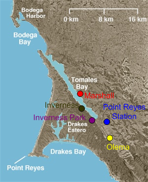
Point Reyes Station is located at , just south and east of the southern end of Tomales Bay, and slightly east of the San Andreas Fault just before the fault submerges down the center of Tomales Bay. Via State Route 1, it is 15 mi northwest of Stinson Beach and 17 mi southeast of Tomales. San Francisco is 42 mi to the southeast via Point Reyes–Petaluma Road, Nicasio Valley Road, and Lucas Valley Road.
Formerly an actual port and railway terminus, Point Reyes Station nominally borders Tomales Bay; the introduction of European cattle and planting of European grass seed on the natural hills caused destructive erosion, and a combination of small dirt dams, silting, and intentional landfill for farming raised the level of former salt marshes and has left Point Reyes Station approximately 0.8 mi from the nearest tidal flats, and that after expenditure of millions of dollars and recent efforts for reclamation of the natural environment.
The CDP has a total area of 3.62 sqmi, all land.
History
Once land of the Coast Miwok Indians, Point Reyes Station gets its name from the nearby Point Reyes Peninsula (a major peninsula sticking out into the Pacific Ocean) and its status as a terminus stop on the North Pacific Coast Railroad connecting Cazadero to the Sausalito ferry.
Point Reyes Station is very close to the San Andreas Fault, which was responsible for the 1906 San Francisco earthquake. At one time, the epicenter of the quake was thought to be near Olema. A walking tour of the fault can be taken from the Point Reyes National Seashore's Visitor Center.
The place was called "Olema Station" when the railroad arrived in 1875. The Point Reyes post office opened in 1882. Its name changed thrice in 1891: first to Marin, then back to Point Reyes, and finally to the modern Point Reyes Station.
Demographics
|align-fn=center 1860–1870 1880-1890 1900 1910 1920 1930 1940 1950 1960 1970 1980 1990 2000 2010
Point Reyes Station first appeared as a census designated place in the 2000 U.S. census.

The 2020 United States census reported that the Point Reyes Station CDP had a population of 895. The population density was 247.5 PD/sqmi. The racial makeup of the CDP was 677 (75.6%) White, 9 (1.0%) African American, 11 (1.2%) Native American, 16 (1.8%) Asian, 4 (0.4%) Pacific Islander, 72 (8.0%) from other races, and 106 (11.8%) from two or more races. Hispanic or Latino of any race were 183 persons (20.4%).
The census reported that 879 people (98.2% of the population) lived in households and 16 (1.8%) were institutionalized.
There were 394 households, out of which 80 (20.3%) had children under the age of 18 living in them, 182 (46.2%) were married-couple households, 26 (6.6%) were cohabiting couple households, 131 (33.2%) had a female householder with no partner present, and 55 (14.0%) had a male householder with no partner present. 136 households (34.5%) were one person, and 84 (21.3%) were one person aged 65 or older. The average household size was 2.23.
The age distribution was 130 people (14.5%) under the age of 18, 40 people (4.5%) aged 18 to 24, 154 people (17.2%) aged 25 to 44, 243 people (27.2%) aged 45 to 64, and 328 people (36.6%) who were 65years of age or older. The median age was 56.0years. For every 100 females, there were 86.1 males.
There were 487 housing units at an average density of 134.7 /mi2, of which 394 (80.9%) were occupied. Of these, 229 (58.1%) were owner-occupied, and 165 (41.9%) were occupied by renters.

Economy
A number of agricultural companies, many using organic and sustainable practices, are located there, including Cowgirl Creamery and Point Reyes Farmstead Cheese Company. Marin Organic operates out of the city.
Education
It is in the Shoreline Unified School District.
References
References
- "County of Marin District 4 webpage". [[County of Marin]].
- "Final Maps {{!}} California Citizens Redistricting Commission".
- {{Cite GovTrack. CA. 2
- "2021 U.S. Gazetteer Files: California". United States Census Bureau.
- "P1. Race – Point Reyes Station CDP, California: 2020 DEC Redistricting Data (PL 94-171)". U.S. Census Bureau.
- is a small unincorporated town in western [[Marin County, California. Marin County]], [[California]], United States. Point Reyes Station is located {{convert. 13. mi. km. 0 south-southeast of [[Tomales, California. 683
- {{gnis. 1659413
- "Decennial Census by Decade".
- "1870 Census of Population - Population of Civil Divisions less than Counties - California - Almeda County to Sutter County".
- "1870 Census of Population - Population of Civil Divisions less than Counties - California - Tehama County to Yuba County".
- "1890 Census of Population - Population of California by Minor Civil Divisions".
- "1900 Census of Population - Population of California by Counties and Minor Civil Divisions".
- "1910 Census of Population - Supplement for California".
- "1920 Census of Population - Number of Inhabitants - California".
- "1930 Census of Population - Number and Distribution of Inhabitants - California".
- "1940 Census of Population - Number of Inhabitants - California".
- "1950 Census of Population - Number of Inhabitants - California".
- "1960 Census of Population - General population Characteristics - California".
- "1970 Census of Population - Number of Inhabitants - California".
- "1980 Census of Population - Number of Inhabitants - California".
- "1990 Census of Population - Population and Housing Unit Counts - California".
- "2000 Census of Population - Population and Housing Unit Counts - California".
- "2010 Census of Population - Population and Housing Unit Counts - California".
- "Point Reyes Station CDP, California; DP1: Profile of General Population and Housing Characteristics - 2020 Census of Population and Housing".
- "Point Reyes Station CDP, California; P16: Household Type - 2020 Census of Population and Housing".
- "2020 CENSUS - SCHOOL DISTRICT REFERENCE MAP: Marin County, CA". [[U.S. Census Bureau]].
This article was imported from Wikipedia and is available under the Creative Commons Attribution-ShareAlike 4.0 License. Content has been adapted to SurfDoc format. Original contributors can be found on the article history page.
Ask Mako anything about Point Reyes Station, California — get instant answers, deeper analysis, and related topics.
Research with MakoFree with your Surf account
Create a free account to save articles, ask Mako questions, and organize your research.
Sign up freeThis content may have been generated or modified by AI. CloudSurf Software LLC is not responsible for the accuracy, completeness, or reliability of AI-generated content. Always verify important information from primary sources.
Report