From Surf Wiki (app.surf) — the open knowledge base
Pilbara
Region of Western Australia

Region of Western Australia
| Field | Value |
|---|---|
| name | Pilbara |
| state | wa |
| type | region |
| image | {{maplink |
| plain | yes |
| frame | yes |
| frame-width | 300 |
| frame-height | 300 |
| frame-align | center |
| zoom | 4 |
| frame-coord | |
| from | Western Australian region - Pilbara.map |
| caption | Extent of Pilbara region |
| coordinates | |
| lga | Shire of Ashburton |
| lga2 | Shire of East Pilbara |
| lga3 | City of Karratha |
| lga4 | Town of Port Hedland |
| stategov | Kimberley |
| stategov2 | Pilbara |
| fedgov | Durack |
|frame-width=300 |frame-height=300 |frame-align=center |frame-coord=
The Pilbara () is a large, dry, sparsely populated region in the north of Western Australia. It is known for its Aboriginal people, its geography, its red earth, and its vast mineral deposits, in particular iron ore. It is also a global biodiversity hotspot for subterranean fauna.
Definitions of the Pilbara region
At least two important but differing definitions of "the Pilbara" region exist. Administratively it is one of the nine regions of Western Australia defined by the Regional Development Commissions Act 1993; the term also refers to the Pilbara shrublands bioregion (which differs in extent) under the Interim Biogeographic Regionalisation for Australia (IBRA).
| IBRA regions and subregions: IBRA7 | IBRA region / subregion | IBRA code | Area | States | Location in Australia | |
|---|---|---|---|---|---|---|
| Pilbara shrublands | PIL | 17823126 ha | WA | [[File:IBRA 6.1 Pilbara.png | 100px]] | |
| Chichester | PIL01 | 8374728 ha | ||||
| Fortescue | PIL02 | 1951435 ha | ||||
| Hamersley | PIL03 | 5634727 ha | ||||
| Roebourne | PIL04 | 1862236 ha |
Geography


The Pilbara region, as defined by the Regional Development Commissions Act 1993 and administered for economic development purposes by the Pilbara Development Commission, has an estimated population of 61,688 , and covers an area of 507,896 sqkm. It contains some of Earth's oldest rock formations, and includes landscapes of coastal plains and mountain ranges with cliffs and gorges. The major settlements of the region are Port Hedland, Karratha and Newman. The three main ports in this region are Port Hedland, Dampier and Port Walcott.
Under the Regional Development Commissions Act, Pilbara is situated south of the Kimberley, and comprises the local government areas of Shire of Ashburton, Shire of East Pilbara, City of Karratha, and Town of Port Hedland.
The Pilbara region covers an area of 507,896 km2 (193,826 mi2) (including offshore islands), roughly the combined land area of the US States of California and Indiana. It has a population of more than 45,000, most of whom live in the western third of the region, in towns such as Port Hedland, Karratha, Wickham, Newman and Marble Bar. A substantial number of people also work in the region on a fly-in/fly-out basis. There are approximately 10 major/medium population centres and more than 25 smaller ones.

The Pilbara consists of three distinct geographic areas. The western third is the Roebourne coastal sandplain, which supports most of the region's population in towns and much of its industry and commerce. The eastern third is almost entirely desert, and is sparsely populated by a small number of Aboriginal people. The two areas are separated by the inland uplands of the Pilbara Craton, including the predominant Hamersley Range, which has numerous mining towns, the Chichester Range, and others. The uplands have many gorges and other natural attractions.
The Pilbara contains some of the world's oldest surface rocks, including the ancient fossilised remains known as stromatolites and rocks such as granites that are more than three billion years old. In 2007, some of the oldest evidence of life on Earth was found in 3.4-billion-year-old sandstones at Strelley Pool, which preserve fossils of sulphur-processing bacteria. The mineralised spheres, which were found on an ancient beach and have a cell-like morphology, were chemically analysed, revealing that they used sulphur for fuel.
An extinct genus of stromatolite-forming cyanobacteria, Pilbaria, was named after the region, where the type specimen was found.
Urban centres and localities
| Rank | UCL | LGA | Population | Ref. | Ref. | Ref. | 2016 census | Ref. | 2021 census | Ref. | |
|---|---|---|---|---|---|---|---|---|---|---|---|
| 1 | Karratha | Karratha | 10,730 | 11,728 | 16,475 | 15,828 | |||||
| 2 | Port Hedland | Port Hedland | 12,695 | 11,557 | 13,772 | 13,828 | |||||
| 3 | Newman | East Pilbara | 3,516 | 4,245 | 5,478 | 4,567 | |||||
| 4 | Tom Price | Ashburton | 3,095 | 2,721 | 3,134 | 2,956 | |||||
| 5 | Wickham | Karratha | 1,724 | 1,825 | 1,651 | 1,572 | |||||
| 6 | Paraburdoo | Ashburton | 1,202 | 1,607 | 1,509 | 1,359 | |||||
| 7 | Dampier | Karratha | 1,469 | 1,370 | 1,341 | 1,104 | |||||
| 8 | Onslow | Ashburton | 802 | 576 | 667 | 848 | |||||
| 9 | Roebourne | Karratha | 950 | 857 | 813 | 627 | |||||
| 10 | Pannawonica | Ashburton | 618 | 686 | 651 | 695 | |||||
| 11 | Jigalong | East Pilbara | 300 | 273 | 357 | 333 | |||||
| 12 | Point Samson | Karratha | 322 | 274 | 298 | 211 | |||||
| 13 | Kiwirrkurra | East Pilbara | 216 | 165 | |||||||
| 14 | Marble Bar | East Pilbara | 234 | 194 | 208 | 174 | |||||
| 15 | Nullagine | East Pilbara | 178 | 194 |
Local government
The Pilbara region, under the Pilbara Development Commission, contains four local government areas:
- AshburtonShire of Ashburton
- East PilbaraShire of East Pilbara
- KarrathaCity of Karratha
- Port HedlandTown of Port Hedland
Etymology
According to the Pilbara Aboriginal Language Centre Wangka Maya, the name for the Pilbara region derives from the Aboriginal word bilybara, meaning "dry" in the Nyamal and Banyjima languages. Another suggested origin is pilbarra, an Aboriginal word for the salt-water mullet found in local waters, reflected in the name of a tributary of the Yule River, Pilbarra Creek, which evolved to "Pilbara" Creek. The Pilbara Goldfield, discovered in 1885, was named after the creek, and the name later became associated with the region.
History
Radiocarbon dating estimates in evidence show that rock art and standing stones at Murujuga in the Dampier Archipelago, Australia's earliest known stone structures, believably dating from 6046 to 5338 BC, are of contextualization by thousands of years of unique cultural traditions and folklore. These sites have lived up as part of survival in present times.
The first European to explore the area was Francis Thomas Gregory in 1861. Within two years, European settlers had begun arriving. The region was regarded as part of the North West at first – a larger area that included the modern Kimberley and Gascoyne regions.
Settlements along the coast at Tien Tsin Harbour (later Cossack), Roebourne and Condon (officially Shellborough; later abandoned) were established over ensuing decades, mainly as centres of the rangeland livestock (grazing/pastoral) industry or pearling ports. However, as natural mother of pearl beds around Cossack were fished out, the pearling fleet began to move northward, and by 1883 it was based at Broome, in the Kimberley region. From , pastoralism went into decline with the growth of other, more productive agricultural areas of the state.
Mining in the region started on 1 October 1888, when the Pilbara Goldfield was officially declared – named after a local creek, the goldfield would later give its name to the region as a whole. It was later divided into the Nullagine Goldfield and Marble Bar Goldfield. However, gold mining began to decline in the Pilbara in the mid-1890s, after alluvial ore had been exhausted. In 1937, mining of asbestos commenced at Wittenoom Gorge. While the presence of abundant iron ore had been known for about a century, it was not until the 1960s and the discovery of high-grade ore in the Hamersley Ranges that the area became pivotal to the state's economy, and towns built to accommodate mining and allied services boomed.
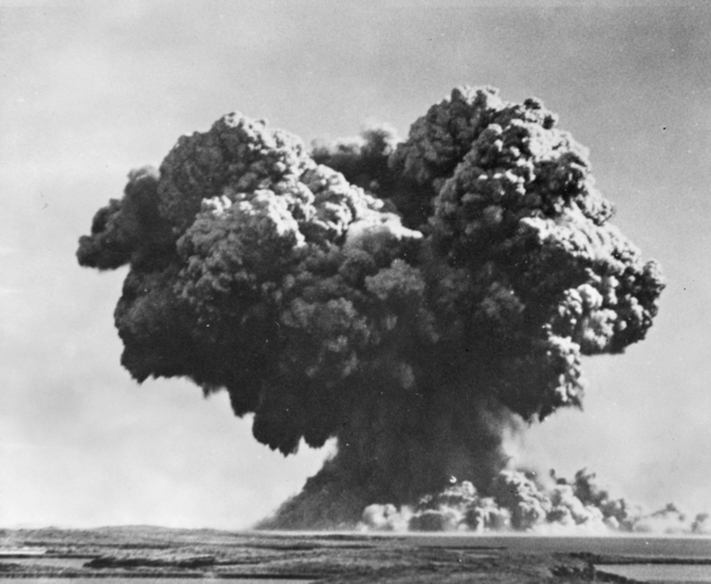
In the 1950s, three British nuclear weapons tests were carried out in the Montebello Islands, 130 km (81 mi) off the Pilbara coast.
Aboriginal people
Prehistory
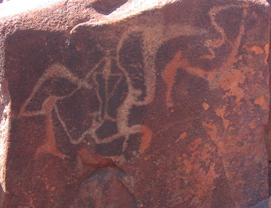
The Aboriginal population of the Pilbara considerably predates, by 30,000 to 40,000 years, the European colonisation of the region. Archaeological evidence indicates that people were living in the Pilbara even during the harsh climatic conditions of the Last Glacial Maximum. The early history of the first people is held within an oral tradition, archeological evidence and petroglyphs. Near the town of Dampier is a peninsula known as Murujuga, which contains a large collection of World Heritage-listed petroglyphs, dating back thousands of years. Rock art in the Pilbara appears to have been mainly etched into the hard rock surfaces, whereas on the softer sandstone in the Kimberley rock paintings predominate.
20th century
Working conditions in the pearling and pastoral industries for Aboriginal people in the Pilbara region around 1900 have been described as slavery, with no wages paid, kidnapping as well as severe and cruel punishments for misbehaviour and absconding all common practices. Some incidents, such as the Bendu Atrocity of 1897, attracted international condemnation. The first strike by Indigenous people in Australia took place in 1946 in the Pilbara, known as the Pilbara strike or Pilbara Aboriginal strike, when Aboriginal pastoral workers walked off the stations in protest at low pay and bad working conditions, a strike that lasted for over three years.
Family clans in the Pilbara who were supported by mining prospector, Don McLeod, developed skills for mining and the concentration of rare metals. For a short period money accumulated, which according to Aboriginal law was to be used for traditional ways. Eventually the funds were used to establish an independent Aboriginal-controlled school. The concept has expanded into a movement with around 20 similar schools established in northern Western Australia by the mid-1990s. Jan Richardson, wife of Victorian Aboriginal activist Stan Davey, wrote a biography of McLeod as a doctoral thesis.
21st century
In 2006, it was estimated that 15% of the population of the Pilbara identify as Aboriginal and/or Torres Strait Islander people, approximately 6000 people.
Many Pilbara communities face the many complex effects of colonisation, and lack adequate access to housing, health and education. A 1971 survey of 1000 Aboriginal people conducted by Pat McPherson found that most had one or more serious diseases. At the McClelland Royal Commission into British nuclear testing, Aboriginal people from the Pilbara provided evidence regarding the explosion on the Montebello Islands.
Aboriginal communities are sited over a number of different places. Many have poor infrastructure, and relations between police and Aboriginal people are often tense.
There are many Aboriginal corporations across the Pilbara, some of which administer Native Title responsibilities, and others which focus on social, health, and education outcomes. Since 2022, the Ngarluma Yindjibarndi Foundation Ltd (NYFL), under the leadership of Yindjibarndi man Michael Woodley, and CEO Sean-Paul Stephens, has become known as one of most impactful organisations in Western Australia, given its focus on advocacy and influence on social and economic policy.
Climate


The climate of the Pilbara is arid and tropical. It experiences high temperatures and low irregular rainfall that follows the summer cyclones. During the summer months, maximum temperatures exceed 32 C almost every day, and temperatures in excess of 45 C are not uncommon. Winter temperatures rarely drop below 10 C on the coast; however, inland temperatures as low as 0 C are occasionally recorded.
The Pilbara town of Marble Bar set a world record of most consecutive days of maximum temperatures of 100 degrees Fahrenheit (37.8 degrees Celsius) or more, during a period of 160 such days from 31 October 1923 to 7 April 1924.
The average annual rainfall in the region is between 200 and. Almost all of the Pilbara's rainfall occurs between December and May, usually with occasional heavy downpours in thunderstorms or tropical cyclones. The period from June to November is usually completely rainless, with warm to very hot and sunny conditions. Like most of the north coast of Australia, the coastal areas of the Pilbara experience occasional tropical cyclones. The frequency of cyclones crossing the Pilbara coast is about 7 every 10 years. Due to the low population density in the Pilbara region, cyclones rarely cause large scale destruction or loss of life. |Jan record high C = 49.0 |Feb record high C = 48.2 |Mar record high C = 45.9 |Apr record high C = 42.4 |May record high C = 38.8 |Jun record high C = 35.5 |Jul record high C = 34.4 |Aug record high C = 36.8 |Sep record high C = 42.2 |Oct record high C = 46.9 |Nov record high C = 47.4 |Dec record high C = 47.9 |year record high C = 49.0 |Jan record low C = 18.1 |Feb record low C = 16.3 |Mar record low C = 15.8 |Apr record low C = 12.2 |May record low C = 7.0 |Jun record low C = 4.7 |Jul record low C = 3.2 |Aug record low C = 3.7 |Sep record low C = 7.7 |Oct record low C = 11.1 |Nov record low C = 12.4 |Dec record low C = 16.6 |year record low C = 3.2
|Jan record high C = 47.0 |Feb record high C = 46.0 |Mar record high C = 43.3 |Apr record high C = 40.4 |May record high C = 35.2 |Jun record high C = 33.0 |Jul record high C = 31.0 |Aug record high C = 34.1 |Sep record high C = 38.0 |Oct record high C = 42.9 |Nov record high C = 43.9 |Dec record high C = 45.0 |year record high C = 47.0 |Jan record low C = 16.1 |Feb record low C = 17.0 |Mar record low C = 9.0 |Apr record low C = 6.0 |May record low C = 1.0 |Jun record low C = -1.1 |Jul record low C = -2.0 |Aug record low C = -2.0 |Sep record low C = 1.0 |Oct record low C = 6.0 |Nov record low C = 11.8 |Dec record low C = 15.2 |year record low C = -2.0
Economy
The area is known for its petroleum, natural gas and iron ore deposits, which contribute significantly to Australia's economy. Other than mining, pastoral activities as well as fishing and tourism are the main industries.
Despite an economic output of over $125 billion per year (as of 2025), the economic wellbeing of the Aboriginal community has deteriorated over the last three decades. Professor Peter Yu of the Australian National University has labeled this disparity as “economic apartheid”. Professor Marcia Langton has written about the extreme disparity between Pilbara Aboriginal communities like Ieramugadu (Roebourne), and towns like Karratha and Dampier, only 45km away, which are home to much of the mining, oil and gas workforce.
In 2025, Seven West Media published an opinion article by Regional Development Australia (Pilbara) board member and CEO of the Ngarluma Yindjibarndi Foundation Ltd (NYFL) Sean-Paul Stephens, on the failure of the Pilbara in achieving economic reconciliation in the years since the Pilbara Strike.
The Pilbara's economy is dominated by mining exports and petroleum export industries.
During the 1970s the area was known for union militancy with many strikes and some mines operating as fully unionised 'closed shops.' This was challenged by employers from the mid-1980s onwards and the region now has a very low level of union membership compared to other parts of Australia.
Iron ore


_Melbourne_Museum.jpg)
Most of Australia's iron ore is mined in the Pilbara, with mines mostly centred around Tom Price and Newman. The iron ore industry employs 9,000 people from the Pilbara area. The Pilbara also has one of the world's major manganese mines, Woodie Woodie, situated 400 km southeast of Port Hedland.
Iron ore deposits were first discovered by prospector Stan Hilditch, who in 1957 found a large iron ore deposit in the southern Ophthalmia Range, at what was to become the Mount Whaleback mine.
In the 1960s, it was reportedly called "one of the most massive ore bodies in the world" by Thomas Price, then vice president of US-based steel company Kaiser Steel. Geoscience Australia calculated that the country's "economic demonstrated resources" of iron amounted to 24 gigatonnes, or 24 billion tonnes. According to the Australian Bureau of Agricultural and Resource Economics, , that resource is being used up at a rate of 324 million tonnes a year, with rates expected to increase over coming years. Experts Gavin Mudd (Monash University) and Jonathon Law (CSIRO) expect it to be gone within 30 to 50 years (Mudd) and 56 years (Law).
, active iron ore mines in the Pilbara are:
- BC Iron
- Iron Valley mine
- BHP
- Area C mine
- Jimblebar mine
- Mount Whaleback mine
- Orebodies 18, 23 and 25 mine
- Yandi mine
- Yarrie mine
- Fortescue
- Christmas Creek mine
- Cloud Break mine
- Rio Tinto
- Brockman mine
- Brockman 4 mine
- Channar mine
- Eastern Range mine
- Hope Downs mine
- Marandoo mine
- Mesa A mine
- Mesa J mine
- Mount Tom Price mine
- Nammuldi mine
- Paraburdoo mine
- West Angelas mine
- Yandicoogina mine
- Atlas Iron
- Pardoo mine
- Moly Mines
- Spinifex Ridge (molybdenum, copper, iron ore)
Liquified natural gas
A significant part of Pilbara's economy is based on liquified natural gas (LNG) through the North West Shelf Venture and Pluto LNG plant, both operated by Woodside.
Despite Woodside’s North West Shelf and Pluto Gas Plants recording record profits over the life of operations, Woodside’s agreements with Traditional Owners have been heavily criticised, given no royalties are provided to the Aboriginal community, and “gag clauses” are enforced through their agreements.
Agriculture

The region also has a number of cattle-grazing stations, and a substantial tourist sector, with popular natural attractions including the Karijini and Millstream-Chichester national parks and the Dampier Archipelago.
Transport

The first railway in the Pilbara region was the narrow-gauge Marble Bar Railway between Port Hedland and Marble Bar. The Marble Bar Railway opened in July 1911 and closed in October 1951. The Roebourne-Cossack Tramway opened in 1897 and many industrial railways have been built to serve the mines.
Five heavy-duty railways are associated with the various iron-ore mines. They are all standard gauge and built to the heaviest North American standards. Rio Tinto runs driverless trains on its railways.
Ports
The ports of the Pilbara are:
- Port Hedland
- Nelson Point and Finucane Island (operated by BHP)
- Herb Elliott Port (operated by the Fortescue)
- Dampier (operated by Rio Tinto)
- Cape Lambert (operated by Rio Tinto)
- Anketell Port (under development)
Ecology
Terrestrial
Main article: Pilbara shrublands

The dominant flora of the Pilbara is acacia trees and shrubs and drought-resistant Triodia spinifex grasses. Several species of acacia (wattle) trees are endemic to the Pilbara and are the focus of conservation programs, along with wildflowers and other local specialities.
"Fairy circles" (known as linyji in the Manyjilyjarra language and mingkirri in the Warlpiri language) which are circular patches of land barren of plants, varying between 2 and in diameter and often encircled by a ring of stimulated growth of grass, are found in the western part of the Great Sandy Desert in the Pilbara. It has not yet been proven what causes these formations, but one theory suggests that they have been built and inhabited by Australian harvester termites since the Pleistocene.
The Pilbara is home to a wide variety of endemic species adapted to this tough environment. There is a high diversity of invertebrates, including hundreds of species of subterranean fauna (both stygofauna and troglofauna), which are microscopic invertebrates that live in caves, vugs or groundwater aquifers of the region, and terrestrial fauna (see short-range endemic invertebrates). The Pilbara olive python, the western pebble-mound mouse, and the Pilbara ningaui of the Hamersley Range are among the many species of animals within the fragile ecosystems of this desert ecoregion. Birds include the Australian hobby, nankeen kestrel, spotted harrier, mulga parrot and budgerigars.
Wildlife has been damaged by the extraction of iron, natural gas and asbestos, but the protection of culturally and environmentally sensitive areas of the Pilbara is now enhanced by the delineation of several protected areas, including the Millstream-Chichester and the Karijini National Parks.
Freshwater
Main article: Pilbara freshwater ecoregion
The western Pilbara is part of the Pilbara freshwater ecoregion, also known as the Pilbara-Gascoyne or Indian Ocean drainage basin. The freshwater region is characterized by intermittent rivers which form deep gorges, and brackish-water caves that host endemic species. The region includes the drainages of the Murchison, Gascoyne, Ashburton, Fortescue, and De Grey rivers. The Great Sandy Desert, which covers the eastern Pilbara, has little freshwater habitat.
Notes
General references
References
References
- (2014). "Pilbara stygofauna: deep groundwater of an arid landscape contains globally significant radiation of biodiversity". Records of the Western Australian Museum, Supplement 78.
- Environment Australia. "Revision of the Interim Biogeographic Regionalisation for Australia (IBRA) and Development of Version 5.1 – Summary Report". [[Department of the Environment and Water Resources]], Australian Government.
- "Australia's Biogeographical Regions - IBRA Version 6.1".
- "Pilbara Development Commission".
- Australian Bureau of Statistics. (31 March 2011). "Regional Population Growth, Australia, 2009–10 – Western Australia".
- (27 June 2009). "Rangelands – Overview – Pilbara". Department of Sustainability, Environment, Water, Population and Communities.
- "Regional Development Australia Pilbara".
- (1 May 2016). "Annual report 2015 – Pilbara ports authority". PPA (Pilbara ports authority).
- "Planning for resources growth in the Pilbara: revised employment & population projections to 2020".
- Amos, Jonathan. (22 August 2011). "Fossil microbes give sulphur insight on ancient Earth". [[BBC News]].
- Elizabeth Pennisi. (21 August 2011). "World's Oldest Fossils Found in Ancient Australian Beach". [[American Association for the Advancement of Science]].
- M. R, Walter. (1972). "Stromatolites and the biostratigraphy of the Australian Precambrian and Cambrian". [[The Palaeontological Association]].
- (28 June 1992). "Bilybara: The Aboriginal Languages of the Pilbara Region of Western Australia". Wangka Maya Pilbara Aboriginal Language Centre.
- "Fishes in groundwater dependent pools of the Fortescue and Yule rivers, Pilbara, Western Australia".
- "Pilbara place names".
- Hema Maps. (1997). "Discover Australia's National Parks". [[Random House]] Australia.
- (2002). "Milly's Cave: Evidence for Human Occupation of the Inland Pilbara during the Last Glacial Maximum". Tempus.
- Olive, Noel. (2007). "Enough is Enough: A History of the Pilbara Mob". Fremantle Press.
- "Articles About Pilbara Aboriginal History".
- (1 May 2018). "Don McLeod – radical activist for Aboriginal justice in the Pilbara, Western Australia".
- Coombs, H.C.. (1994). "Aboriginal Autonomy: Issues and Strategies". Press Syndicate of the University of Cambridge.
- (19 February 2018). "Biography of an Australian hero: interview with PhD alum Jan Richardson".
- Richardson, Jan. (2017). "'They couldn't break me': Don McLeod, champion for Aboriginal justice in the Pilbara.". [[Monash University]]..
- [http://www.csiro.au/en/Organisation-Structure/Flagships/Water-for-a-Healthy-Country-Flagship/~/media/CSIROau/Files/PDF/p12ei.pdf Water and Indigenous People in the Pilbara] ''[[CSIRO]]'' study, published: September 2011, accessed: 1 December 2011
- "Centre for Responsible Citizenship and Sustainability (CRCS) | Research Capabilities | Murdoch University in Perth Australia".
- "Australian Psychological Society : Changing practices, changing paradigms: Working effectively with Indigenous clients".
- Griffiths, Max. (2006). "Aboriginal Affairs 1967–2005: Seeking a Solution". Rosenberg Publishing.
- (30 August 1984). "Royal Commission probes British nuclear tests in Australia". Reed Elsevier.
- [http://www.dia.wa.gov.au/Documents/Maps/Maps%20June10/WAComsA4.pdf Western Australia Aboriginal Communities]. Department of Indigenous Affairs.
- "Outcomes from the Indigenous Pilbara Dialogue".
- "Centre for Responsible Citizenship and Sustainability (CRCS) – Research Capabilities – Murdoch University in Perth Australia".
- Australian Human Rights Commission. "Indigenous Deaths in Custody: Chapter 6 Police Practices".
- "Marble Bar heatwave, 1923–1924". [[Bureau of Meteorology]].
- "Australian Climate Averages - Tropical cyclones".
- "Climate statistics".
- (19 January 2011). "Department of Health: Pilbara". Government of Western Australia.
- "REMPLAN Region Profiles and Explorers".
- Taylor, John. (2006). "Indigenous people and the Pilbara mining boom: A baseline for regional participation". ANU Press.
- Ikonomou, Tess. (2022-06-22). "Indigenous people facing 'economic apartheid', policy shift needed".
- (2010). "Still the lucky country?". Griffith Univ.
- (2025-05-22). "What non-Indigenous Australia must ask itself this week".
- "The Pilbara's oil and gas industry is the region's largest export industry earning $5.0 billion in 2004/05 accounting for over 96% of the State's production".
- Peoples History of Australia. (2020-04-09). "People's History of Australia Podcast. Episode 10 – The epic story of mining unionism in the Pilbara".
- "Stan Hilditch". State Library of Western Australia.
- Pincock, Stephen. (14 July 2010). "Iron ore country". Australian Broadcasting Corporation.
- (12 December 2010). "Mining Journal – Spinifex gets Chinese finance approval".
- Kurmelovs, Royce. (2022-03-24). "Indigenous elders in WA say ‘gag clause’ denies them a say in industrial developments on their land". The Guardian.
- Joyce, J. and Tilley, Allan, "Railways in the Pilbara," (1979). {{ISBN. 0959969926.
- (11 July 2008). "Iron-ore railway automation project, Western Australia". Mineprocessing.com.
- (3 April 2023). "First Peoples' knowledge leads scientists to reveal 'fairy circles' and termite linyji are linked in Australia". Nature Publishing Group.
- Angeloni, Alice. (4 April 2023). "Indigenous knowledge leads scientists to reveal 'fairy circles', termites linked".
- "Pilbara".
This article was imported from Wikipedia and is available under the Creative Commons Attribution-ShareAlike 4.0 License. Content has been adapted to SurfDoc format. Original contributors can be found on the article history page.
Ask Mako anything about Pilbara — get instant answers, deeper analysis, and related topics.
Research with MakoFree with your Surf account
Create a free account to save articles, ask Mako questions, and organize your research.
Sign up freeThis content may have been generated or modified by AI. CloudSurf Software LLC is not responsible for the accuracy, completeness, or reliability of AI-generated content. Always verify important information from primary sources.
Report