From Surf Wiki (app.surf) — the open knowledge base
Pierre, South Dakota
Capital city of South Dakota, United States
.jpg)
Capital city of South Dakota, United States
| Field | Value |
|---|---|
| name | Pierre, South Dakota |
| settlement_type | State capital city |
| image_skyline | {{multiple image |
| border | infobox |
| total_width | 280 |
| image_style | border:1; |
| perrow | 1/2/2 |
| image1 | Pierre, South Dakota (2022).jpg |
| caption1 | Downtown Pierre (2022) |
| image2 | South Dakota State Capitol, Capitol Avenue, Pierre, SD - 53748194705.jpg |
| caption2 | South Dakota State Capitol |
| image3 | Soldiers and Sailors World War Memorial, Capitol Avenue, Pierre, SD - 53748188365.jpg |
| caption3 | Soldiers and Sailors World War Memorial |
| image4 | Federal Building, Pierre, South Dakota.jpg |
| caption4 | Federal Building |
| image5 | St. Charles Hotel, Pierre, South Dakota.jpg |
| caption5 | St. Charles Hotel |
| image_flag | Flag of Pierre, South Dakota.png |
| flag_size | 90 |
| image_seal | Seal of Pierre, South Dakota.png |
| seal_size | 80 |
| image_blank_emblem | Pierre, SD Logo.png |
| blank_emblem_type | Logo |
| blank_emblem_size | 120 |
| motto | "On The River-On The Move" |
| image_map | Hughes County South Dakota Incorporated and Unincorporated areas Pierre Highlighted.svg |
| mapsize | 250px |
| map_caption | Location within Hughes County in South Dakota |
| pushpin_map | South Dakota#USA |
| pushpin_map_caption | Location within South Dakota##Location within the United States |
| pushpin_relief | yes |
| pushpin_label | Pierre |
| coordinates | |
| subdivision_type | Country |
| subdivision_name | United States |
| subdivision_type1 | State |
| subdivision_type2 | County |
| subdivision_name1 | South Dakota |
| subdivision_name2 | Hughes |
| established_title | Founded |
| established_date | 1880 |
| established_title2 | Incorporated |
| established_date2 | 1883 |
| established_title3 | Chartered |
| established_date3 | 1900 |
| named_for | Pierre Chouteau Jr. |
| leader_title | Mayor |
| leader_name | Steve Harding |
| leader_title1 | |
| unit_pref | Imperial |
| area_footnotes | |
| area_total_km2 | 33.80 |
| area_total_sq_mi | 13.05 |
| area_land_km2 | 33.74 |
| area_land_sq_mi | 13.03 |
| area_water_km2 | 0.05 |
| area_water_sq_mi | 0.02 |
| area_water_percent | 0.08 |
| elevation_footnotes | |
| elevation_ft | 1700 |
| population_total | 14,091 |
| population_as_of | 2020 |
| population_footnotes | |
| population_density_km2 | 417.63 |
| population_density_sq_mi | 1081.68 |
| timezone | CST |
| utc_offset | -06:00 |
| timezone_DST | CDT |
| utc_offset_DST | -05:00 |
| blank_name | FIPS code |
| blank_info | 46-49600 |
| blank1_name | GNIS feature ID |
| blank1_info | 1267533 |
| postal_code_type | ZIP code |
| postal_code | 57501 |
| area_code | 605 |
| website |
Pierre ( ) is the capital city of the U.S. state of South Dakota and the county seat of Hughes County. As of the 2020 census, its population was 14,091. Pierre is the eleventh-most populous city of South Dakota, and the second-least populous U.S. state capital (after only Montpelier, Vermont).
Founded in 1880 on the Missouri River, the city was selected to be the state capital when South Dakota was admitted as a state in 1889. Near the center of the state, the then-new settlement was across the river from the settlement of Fort Pierre, and near what became an important railroad crossing of the River.
History
Pierre was founded in 1880 on the east bank of the Missouri River opposite Fort Pierre, a former trading post that developed as a community. It was designated as the state capital when South Dakota gained statehood on November 2, 1889.
Huron challenged the city to be selected as the capital, but Pierre was selected for its geographic centrality in the state. Fort Pierre had developed earlier, with a permanent settlement since around a fur trading post. Fort Pierre Chouteau, preceding the city, was named after Pierre Chouteau, Jr., an American fur trader from St. Louis, Missouri, who was of colonial French origin.
Pierre's development was also influenced by construction of the Rapid City, Pierre and Eastern Railroad, which runs east–west through the city. It increased access to markets for regional products and improved transportation for passengers. The railroad crosses the Missouri River on the Chicago and North Western Railroad Bridge.
The capital city became relatively isolated in the post-World War II era of federally subsidized highway construction, as travelers and freight companies began to use automobiles and trucking. It is one of four state capitals not served by the Interstate Highway System.
Geography
According to the United States Census Bureau, the city has an area of 13.07 sqmi, of which 13.06 sqmi is land and 0.01 sqmi is water.
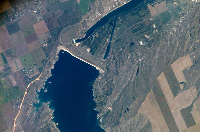
Pierre is sited on rough river bluffs above the east bank of the Missouri River, overlooking its expanse. It is a few miles away from Lake Oahe, one of the world's largest man-made lakes. Developed for flood control and irrigation, the lake has become a popular fishing destination.
Climate
Pierre has a relatively dry, four-season, humid continental climate (Köppen: Dfa, Trewartha: Dcao), with long, dry, cold winters, hot summers, and brief spring and autumnal transitions; like much of the southern half of the state, it lies in USDA Plant Hardiness zone 5. According to weather maps and their data, Pierre can be considered a cool semi-arid climate (Köppen: BSk) aided by its precipitation near the threshold that reaches even northeast of the city in South Dakota. As such, it is the only capital of the Midwest states with a non-humid climate. The monthly daily average temperature ranges from 19.1 F in January to 74.9 F, though the diurnal temperature variation is significantly greater during summer than in winter. Snow primarily falls in light amounts, with the snowiest months being February and March, while the average seasonal total is 37.2 in. In addition, there are an average 20.9 nights per year with lows below 0 F, and cold conditions are often intensified by the Great Plains' high winds. Summers often see spikes in temperature, with 6.6 days of highs above 100 F and 37–38 days with highs above 90 F.
_-_PIERRE_REGIONAL_AP,SD.svg)
On July 23, 1973, an F3 tornado struck Pierre and caused 10 injuries. It was the strongest tornado ever recorded in Hughes County.
The beginnings of May and October see the last and first freezing nights, respectively, of the cooler season. Precipitation is much lighter in the winter than in late spring and summer, and totals about 20 in annually. Extremes have ranged from -35 F on February 9, 1994, to 117 F on July 15, 2006.
|Jan record high F = 68 |Feb record high F = 75 |Mar record high F = 88 |Apr record high F = 98 |May record high F = 105 |Jun record high F = 112 |Jul record high F = 117 |Aug record high F = 114 |Sep record high F = 108 |Oct record high F = 98 |Nov record high F = 87 |Dec record high F = 77 |year record high F = 117 |Jan avg record high F = 52.5 |Feb avg record high F = 58.2 |Mar avg record high F = 74.0 |Apr avg record high F = 84.3 |May avg record high F = 89.8 |Jun avg record high F = 96.6 |Jul avg record high F = 103.0 |Aug avg record high F = 101.9 |Sep avg record high F = 97.5 |Oct avg record high F = 86.1 |Nov avg record high F = 69.1 |Dec avg record high F = 54.5 |year avg record high F = 105.0 |Jan avg record low F = -13.6 |Feb avg record low F = -8.8 |Mar avg record low F = -0.2 |Apr avg record low F = 17.2 |May avg record low F = 30.2 |Jun avg record low F = 43.9 |Jul avg record low F = 50.5 |Aug avg record low F = 47.4 |Sep avg record low F = 33.4 |Oct avg record low F = 18.9 |Nov avg record low F = 5.3 |Dec avg record low F = -8.0 |year avg record low F = -18.8 |Jan record low F = −33 |Feb record low F = −35 |Mar record low F = −20 |Apr record low F = 0 |May record low F = 21 |Jun record low F = 34 |Jul record low F = 42 |Aug record low F = 39 |Sep record low F = 21 |Oct record low F = 2 |Nov record low F = −18 |Dec record low F = −31 |year record low F = -35 |access-date = October 13, 2021}}{{cite web |access-date = October 13, 2021 |archive-url = https://web.archive.org/web/20230703145433/https://www.ncei.noaa.gov/access/services/data/v1?dataset=normals-monthly-1991-2020&startDate=0001-01-01&endDate=9996-12-31&stations=USW00024025&format=pdf |archive-date = 2023-07-03}}
Demographics
|align-fn=center 2018 Estimate Pierre is the principal city of the Pierre micropolitan area, which includes all of Hughes and Stanley counties.
2010 census
As of the census of 2010, there were 13,646 people, 5,778 households, and 3,463 families living in the city. The population density was 1044.9 PD/sqmi. There were 6,159 housing units at an average density of 471.6 /sqmi. The racial makeup of the city was 85.1% White, 0.5% African American, 10.9% Native American, 0.6% Asian, 0.5% from other races, and 2.4% from two or more races. Hispanic or Latino people of any race were 1.9% of the population.
There were 5,778 households, of which 29.2% had children under the age of 18 living with them, 45.7% were married couples living together, 10.4% had a female householder with no husband present, 3.8% had a male householder with no wife present, and 40.1% were non-families. 35.0% of all households were made up of individuals, and 11% had someone living alone who was 65 years of age or older. The average household size was 2.23 and the average family size was 2.87.
The median age in the city was 39.3 years. 22.9% of residents were under the age of 18; 7.5% were between the ages of 18 and 24; 26.7% were from 25 to 44; 28.9% were from 45 to 64; and 13.9% were 65 years of age or older. The gender makeup of the city was 47.8% male and 52.2% female.
2000 census
As of the census of 2000, there were 13,876 people, 5,567 households, and 3,574 families living in the city. The population density was 1,065.8 /mi2. There were 5,949 housing units at an average density of 457.0 /mi2. The racial makeup of the city was 88.91% White, 0.20% African American, 8.56% Native American, 0.46% Asian, 0.02% Pacific Islander, 0.29% from other races, and 1.56% from two or more races. Hispanics or Latinos of any race were 1.25% of the population.
There were 5,567 households, out of which 32.9% had children under the age of 18 living with them, 51.6% were married couples living together, 9.5% had a female householder with no husband present, and 35.8% were non-families. 31.5% of all households were made up of individuals, and 10.7% had someone living alone who was 65 years of age or older. The average household size was 2.35, and the average family size was 2.96.
In the city, the population was spread out, with 27.2% under the age of 18, 6.5% from 18 to 24, 28.6% from 25 to 44, 23.6% from 45 to 64, and 14.1% who were 65 years of age or older. The median age was 38 years. For every 100 females, there were 90.5 males. For every 100 females age 18 and over, there were 85.4 males.
As of 2000 the median income for a household in the city was $42,962, and the median income for a family was $52,144. Males had a median income of $32,969 versus $22,865 for females. The per capita income for the city was $20,462. About 5.5% of families and 7.8% of the population were below the poverty line, including 7.9% of those under age 18 and 9.2% of those age 65 or over.
Education
The Pierre School District, the school district covering the city, oversees three elementary schools, a middle school and a high school, T. F. Riggs High School. St. Joseph is a private Catholic elementary school. It is administered by the local parish and the Diocese of Sioux Falls. Other schools include For His Glory and the Pierre Indian Learning Center (a tribal school affiliated with the Bureau of Indian Education).
Media
Television
| Television |
|---|
| Channel |
| (Digital) |
| 7.1 |
| 11.1 |
| 11.2 |
| 13.1 |
| 13.2 |
| 13.3 |
| 34.1 |
| 46.1 |
| 46.2 |
AM radio
| AM radio stations | Frequency | Call sign |
|---|---|---|
| 1060 AM | KGFX | |
| 1240 AM | KCCR |
FM radio
| FM radio stations | Frequency | Call sign |
|---|---|---|
| 89.1 FM | KVFL | |
| 89.5 FM | K208FM | |
| 90.3 FM | KSLP | |
| 91.7 FM | KTSD | |
| 92.7 FM | KGFX-FM | |
| 94.5 FM | KPLO-FM | |
| 95.3 FM | KLXS | |
| 96.3 FM | K242CH | |
| 98.9 FM | K255DE | |
| 100.1 FM | KJBI | |
| 100.5 FM | K263AW | |
| 104.5 FM | KCCR-FM | |
| 105.1 FM | KPGN-LP | |
| 107.1 FM | K296FI |
Newspaper
The Capital Journal is the local newspaper and has been in circulation since 1881. OaheTV is the local public/education/government cable channel serving Pierre, Fort Pierre on Midcontinent Communications Cable.
Infrastructure
Transportation
Public transit is provided by River Cities Public Transit.
Pierre Regional Airport is served by one commercial airline.
Although in the center of the state, Pierre is one of only four state capitals not served by an Interstate highway (along with Dover, Delaware, Jefferson City, Missouri, and Juneau, Alaska). It is the only one that is not served by any expressways. The nearest Interstate highway is Interstate 90, about 34 mi south of Pierre via the four-lane U.S. Highway 83.John E. Miller, Looking for History on Highway 14 (Pierre: South Dakota State Historical Society Press, 2001)
The Rapid City, Pierre and Eastern Railroad runs east–west through the city. The railroad crosses the Missouri River on the Chicago and North Western Railroad Bridge.
Notable people
- Angela Aames, actress
- Grey Zabel, National Football League 18th overall draft pick 2025
- Floyd Bannister, Major League Baseball player
- Joseph Bottum, writer
- Dan Davis, writer and former fugitive
- Robert Gleckler, actor
- Dusty Johnson, U.S. representative from South Dakota
- Byron S. Payne, Attorney General of South Dakota
- Rex Robbins, actor
- Mike Rounds, U.S. senator from South Dakota and former governor of South Dakota (resident of Fort Pierre).
- John Thune, U.S. senator from South Dakota
In popular culture
In 2015, in honor of the 80th anniversary of the Monopoly board game, Hasbro held an online vote to determine which cities should be included in an updated version of the "Here and Now: The US Edition" of the game. The top "Boardwalk" spot went to an unexpected contender: Pierre. It received the most votes, beating New York, Los Angeles, Chicago, and Boston. The outcome may have been influenced by the image that accompanied the name of the city in the balloting: the well-known Mount Rushmore, which is 150 miles west of Pierre, in Keystone and the Black Hills section of the state.
References
References
- (1976). "Pierre". Macmillan Educational Corporation.
- {{cite EB1911
- "Pierre, SD - Official Website". City of Pierre, South Dakota.
- "ArcGIS REST Services Directory". United States Census Bureau.
- {{GNIS. 1267533
- "Find a County". National Association of Counties.
- "Part VII - Miscellaneous Interstate Facts - Engineering Data - Interstate System - Highway History - Federal Highway Administration".
- "US Gazetteer files 2010". [[United States Census Bureau]].
- Peel, M.C., Finlayson, B.L., and McMahon, T.A.: [https://upload.wikimedia.org/wikipedia/commons/8/82/Americas_K%C3%B6ppen_Map.png Updated American map of the Köppen-Geiger climate classification.] Earth Syst. Sci., 11, 1633–1644, 2007.
- "What is my arborday.org Hardiness Zone?".
- Data, US Climate. "Climate Pierre - South Dakota and Weather averages Pierre - Weather history january 2018".
- "Interactive United States Koppen-Geiger Climate Classification Map".
- "Updated Köppen-Geiger climate map of the world".
- "Tornado History Project: 19730723.46.22".
- "Tornado History Project: Hughes County, South Dakota".
- United States Census Bureau. "Census of Population and Housing".
- (April 2020). "Population Estimates". [[United States Census Bureau]].
- "Census Population API". United States Census Bureau.
- "U.S. Census website". [[United States Census Bureau]].
- "2020 CENSUS - SCHOOL DISTRICT REFERENCE MAP: Hughes County, SD". [[U.S. Census Bureau]].
- "The Dwight D. Eisenhower System of Interstate and Defense Highways - Part VII - Miscellaneous Interstate Facts". Federal Highway Administration.
- Ellis, Jonathan. (June 9, 2017). "South Dakotan recalls life as international fugitive in memoir". [[USA Today]].
- (June 1, 1949). "Byron S. Payne Funeral Friday". The Daily Plainsman.
- "THUNE, John".
- Burbach, Kevin. (March 19, 2015). "Pierre Gets Top Spot on New Monopoly Game". [[Argus Leader]].
- (December 2023). "Monopoly". BuzzFeed.
- "Distance between Pierre, SD and Keystone, SD".
This article was imported from Wikipedia and is available under the Creative Commons Attribution-ShareAlike 4.0 License. Content has been adapted to SurfDoc format. Original contributors can be found on the article history page.
Ask Mako anything about Pierre, South Dakota — get instant answers, deeper analysis, and related topics.
Research with MakoFree with your Surf account
Create a free account to save articles, ask Mako questions, and organize your research.
Sign up freeThis content may have been generated or modified by AI. CloudSurf Software LLC is not responsible for the accuracy, completeness, or reliability of AI-generated content. Always verify important information from primary sources.
Report