From Surf Wiki (app.surf) — the open knowledge base
Perth and Kinross
Council area of Scotland

Council area of Scotland
| Field | Value | |
|---|---|---|
| name | Perth and Kinross | |
| native_name | {{Unbulleted list | |
| settlement_type | Lieutenancy and council area | |
| image_shield | Coat of Arms of the Area Council of Perth and Kinross.svg | |
| image_map | Perth and Kinross UK location map.svg | |
| map_caption | Perth and Kinross shown within Scotland | |
| coordinates | ||
| subdivision_type | Sovereign state | |
| subdivision_name | United Kingdom | |
| subdivision_type1 | Country | |
| subdivision_name1 | Scotland | |
| subdivision_type3 | Lieutenancy area | |
| established_title | Unitary authority | |
| established_date | 1 April 1996 | |
| seat_type | AdministrativeHQ | |
| seat | 2 High Street, Perth | |
| government_footnotes | ||
| government_type | Council | |
| governing_body | Perth and Kinross Council | |
| leader_title | Control | |
| leader_name | ||
| leader_title3 | MPs | |
| leader_name3 | {{Collapsible list | title=2 MPs |
| leader_title4 | MSPs | |
| leader_name4 | {{Collapsible list | title=2 MSPs |
| area_footnotes | ||
| area_total_km2 | ||
| area_rank | [](subdivisions-of-scotland-council-areas) | |
| population_footnotes | ||
| population_as_of | ||
| population_total | ||
| population_rank | [](subdivisions-of-scotland-council-areas) | |
| population_density_km2 | ||
| timezone1 | GMT | |
| utc_offset1 | +0 | |
| timezone1_DST | BST | |
| utc_offset1_DST | +1 | |
| postal_code_type | Postcode areas | |
| area_code_type | Dialling codes | |
| iso_code | GB-PKN | |
| blank1_name | GSS code | |
| blank1_info | S12000048 | |
| website |
|gd |sco |Dave Doogan (SNP) |Pete Wishart (SNP) |Jim Fairlie (SNP) |John Swinney (SNP)
Perth and Kinross (; ) is one of the 32 council areas of Scotland, and a lieutenancy area. It is bordered by Highland and Aberdeenshire to the north, Angus, Dundee, and Fife to the east, Clackmannanshire to the south, and Stirling and Argyll and Bute to the west.
Geographically the area is split by the Highland Boundary Fault into a more mountainous northern part and a flatter southern part. The northern area is a popular tourist spot, while agriculture makes an important contribution to the southern part of the area.
The area is run by Perth and Kinross Council, which is based in Perth.
History
The area takes its name from the two historical shires of Perthshire and Kinross-shire. Each was administered by a sheriff from medieval times, supplemented by commissioners of supply from 1667 and then by a county council from 1890.

Perthshire was one of the largest counties, whereas Kinross-shire was one of the smallest; it was the least populous Scottish county in the 1921 census. In 1930 the county councils for Perthshire and Kinross-shire were combined for most purposes. The two councils continued to be elected as separate bodies, but operated together as the 'Perth and Kinross Joint County Council', serving the combined area of the two counties.
Local government was reformed in Scotland in 1975 under the Local Government (Scotland) Act 1973. Mainland Scotland's counties, burghs and landward districts were replaced with a two-tier structure of upper-tier regions and lower-tier districts. Perth and Kinross was created as one of the districts within the Tayside region. As established in 1975, Perth and Kinross covered the whole of Kinross-shire, and the majority of the pre-1975 Perthshire, with three exceptions: a large area in the south-west of the county which went to the new Stirling district, Muckhart which went to Clackmannan district, and Longforgan which went to the city of Dundee. Perth and Kinross also included the parish of Kettins from Angus. A lieutenancy area covering the same area as the new district was created at the same time.
In 1996, local government in Scotland was reformed again under the Local Government etc. (Scotland) Act 1994. The regions and districts were abolished and replaced by unitary council areas. One such area was named by the 1994 Act as 'Perthshire and Kinross', covering the area of the 1975–1996 district of Perth and Kinross, plus an area transferred from Dundee roughly matching the pre-1975 parish of Longforgan. The shadow authority elected in 1995 to oversee the transition requested a change of name from 'Perthshire and Kinross' to 'Perth and Kinross' in December 1995, which was agreed by the government before the new council area came into force on 1 April 1996. The Perth and Kinross lieutenancy area was adjusted to match the new council area in 1996.
Geography
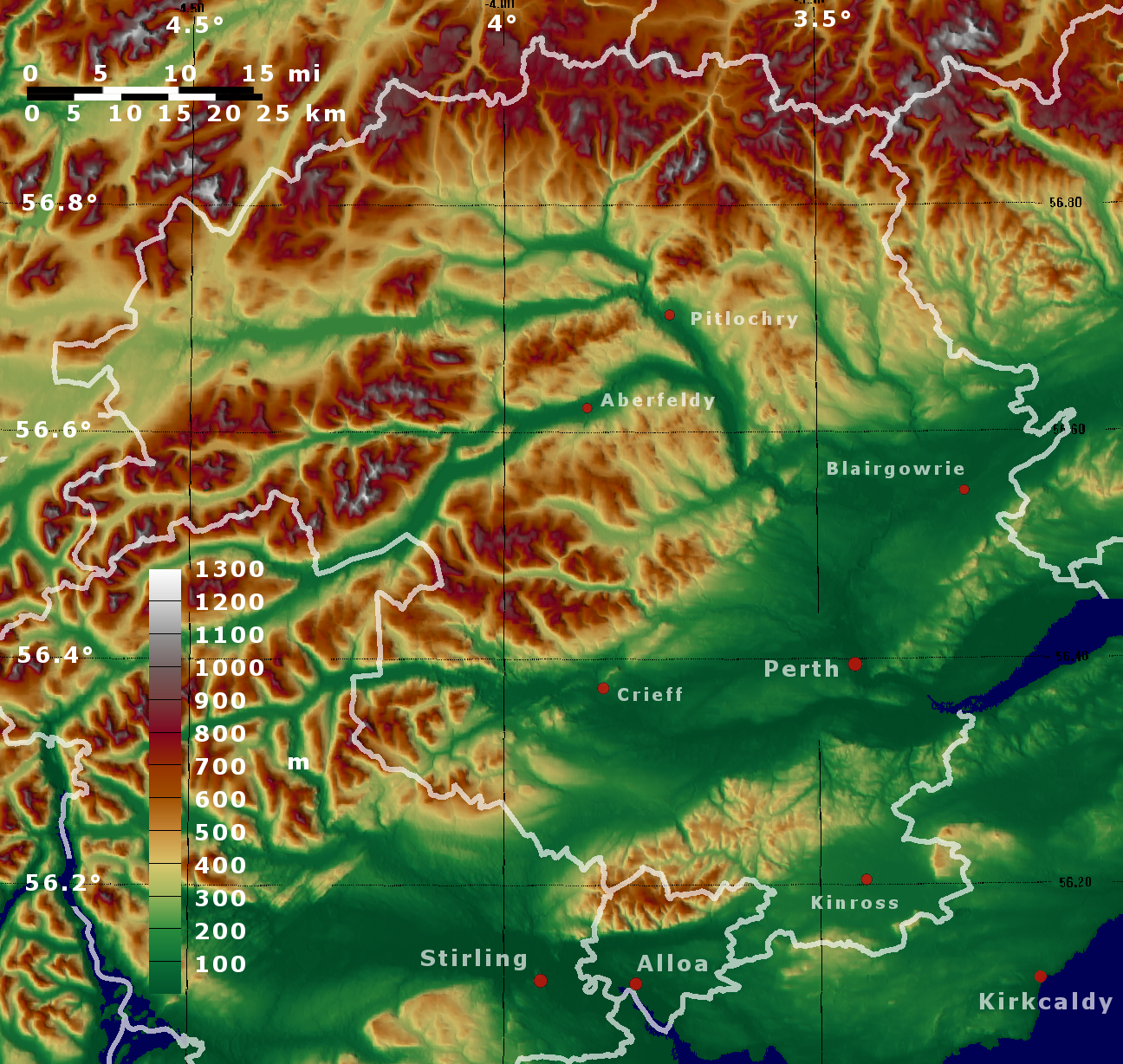
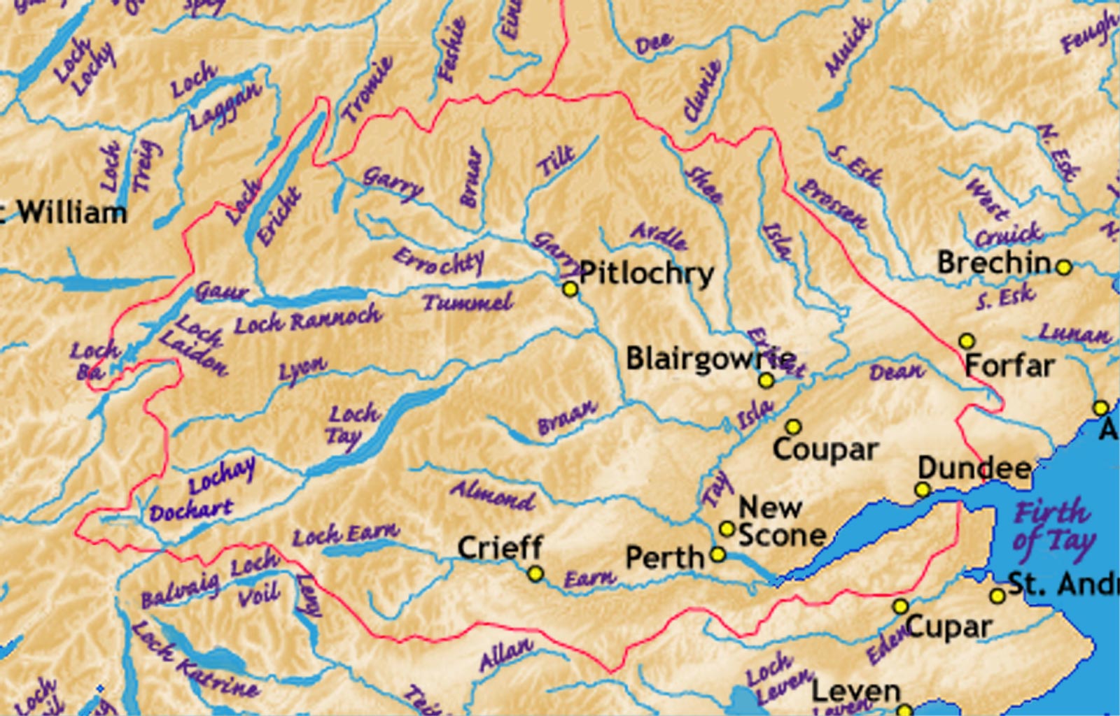
The Highland Boundary Fault runs across the region from the northeast to the southwest. This roughly divides the area between highland Perthshire, including part of the Grampian Mountains, to the north, and lowland Perthshire and Kinross to the south. The highland area is intersected with glacial valleys, often containing ribbon lakes, including Loch Tay and Loch Earn. The lowland area is a fertile region lying within the Central Lowlands.
River Tay, the longest river in Scotland, flows through the mountainous terrains of Perthshire and Kinross. Emerging from Loch Tay, it flows eastward and, after joining the River Isla, it turns south and runs through Perth, before entering the Firth of Tay.
Languages
The 2022 Scottish Census reported that out of 147,257 residents aged three and over, 46,713 (31.7%) considered themselves able to speak or read the Scots language.
The 2022 Scottish Census reported that out of 147,254 residents aged three and over, 1,974 (1.3%) considered themselves able to speak or read Gaelic.
Economy
In the southern part of Perth and Kinross agriculture plays an important part of the local economy. This includes the cultivation of fruits, fodder, wheat and seed potatoes.
The scenic nature of the northern part of Perth and Kinross makes tourism an important part of the economy. The Forestry Commission controls large parts of the area, which is also home to a number of hydroelectric dams.
Settlements
Largest settlements by population
| Settlement | Population () |
|---|---|
| Perth | |
| Blairgowrie and Rattray | |
| Crieff | |
| Auchterarder | |
| Kinross | |
| Scone | |
| Bridge of Earn | |
| Pitlochry | |
| Alyth | |
| Coupar Angus | |
| Milnathort | |
| Aberfeldy | |
| Comrie | |
| Invergowrie | |
| Luncarty | |
| Stanley | |
| Errol | |
| Inchture | |
| Abernethy | |
| Almondbank |
Places of interest
- Ashintully Castle
- Atholl Country Life Museum
- Ben Lawers
- Blackhall Roman Camps
- Blair Atholl Mill
- Blair Castle
- Cateran Trail
- Cairngorms National Park
- Castle Menzies
- Clan Donnachaidh Centre
- Cluny House Gardens
- Dirnanean House
- Drummond Castle
- Edradour Distillery
- Elcho Castle
- Forest of Atholl
- Fortingall Yew
- Glen Lyon
- Grampian Mountains
- Kindrogan House
- Lendrick Muir School
- Loch Earn
- Loch Lomond and the Trossachs National Park
- Loch Rannoch
- Loch Tay
- Melville Monument
- Portmoak
- Rannoch Moor
- Strathearn
- Whitefield Castle
Politics and governance
Local government
Main article: Perth and Kinross Council

The local authority is Perth and Kinross Council, which meets at 2 High Street, Perth.
Scottish Parliament
Perth and Kinross is covered by two Scottish Parliament constituencies and one electoral region. Following the 2021 Scottish Parliament election these two constituencies—Perthshire South and Kinross-shire and Perthshire North—are held respectively by Jim Fairlie and John Swinney, both members of the Scottish National Party. Following the same election the electoral region—Mid Scotland and Fife—is represented by four members of the Scottish Conservatives, two members of Scottish Labour, and one member of the Scottish Greens.
UK Parliament
Perth and Kinross is covered by three United Kingdom Parliament constituencies; Perth and Kinross-shire, Angus and Perthshire Glens and Stirling and Strathallan. Following the 2024 UK Parliamentary General Election these seats are respectively held by Pete Wishart (Scottish National Party), Dave Doogan (Scottish National Party) and Chris Kane (Labour Party).
Referendums
On 18 September 2014, Perth and Kinross voted strongly "No" in the Scottish Independence Referendum, with a majority of 60.2% on a record turnout of 86.9%.
On 23 June 2016, Perth and Kinross voted in favour of remain in the Brexit referendum, with a majority of 61.1% on a turnout of 73.7%.
References
References
- "Your council".
- {{UK subdivision statistics citation
- "Act of the convention of estates of the kingdom of Scotland etc. for a new and voluntary offer to his majesty of £72,000 monthly for the space of twelve months, 23 January 1667". University of St Andrews.
- [[Local Government (Scotland) Act 1889]]
- "1921 Census of Scotland, County Report". GB Historical GIS / University of Portsmouth.
- {{cite legislation UK. (1929)
- {{London Gazette. (16 March 1971)
- {{cite legislation UK. (1973)
- {{cite legislation UK. (1975)
- {{cite legislation UK. (1994)
- (2018). "The Columbia Encyclopedia - Credo Reference". Columbia University Press.
- (2018). "The Columbia Encyclopedia - Credo Reference". Columbia University Press.
- "Historical information on changes to electoral arrangements of Local authorities, Parliamentary areas and European Parliamentary boundaries". Ordnance Survey.
- {{cite legislation UK. (1996)
- "Perth and Kinross". Encyclopædia Britannica, Inc.
- [https://www.scotlandscensus.gov.uk/webapi/opentable?id=019a1a62-eab8-76fc-98d0-f7e8423a5077]
- [https://www.scotlandscensus.gov.uk/webapi/opentable?id=019a2022-ecdd-77ea-96ad-569f0c5b3786]
- (2018). "The Hutchinson Unabridged Encyclopedia with Atlas and Weather Guide - Credo Reference". Helicon.
- {{Scottish settlement population citation
- (7 January 2020). "MPs and MSPs". Perth & Kinross Council.
- "Perthshire South and Kinross-shire". [[BBC News]].
- "Perthshire North". [[BBC News]].
- "Mid Scotland and Fife". [[BBC News]].
- (23 July 2024). "UK Parliamentary General Election results".
- "UK Parliamentary Election results".
- (5 July 2024). "2024 UK General Election result - Stirling and Strathallan".
- "Scotland Decides". BBC.
- "EU Referendum local results - P". BBC.
This article was imported from Wikipedia and is available under the Creative Commons Attribution-ShareAlike 4.0 License. Content has been adapted to SurfDoc format. Original contributors can be found on the article history page.
Ask Mako anything about Perth and Kinross — get instant answers, deeper analysis, and related topics.
Research with MakoFree with your Surf account
Create a free account to save articles, ask Mako questions, and organize your research.
Sign up freeThis content may have been generated or modified by AI. CloudSurf Software LLC is not responsible for the accuracy, completeness, or reliability of AI-generated content. Always verify important information from primary sources.
Report