From Surf Wiki (app.surf) — the open knowledge base
Pensacola, Florida
| Field | Value |
|---|---|
| name | Pensacola, Florida |
| settlement_type | City |
| nicknames | "The Upside of Florida", "The City of Five Flags", "Festival City of the South", and "Cradle of Naval Aviation" |
| motto | "Florida's First & Future" |
| image_skyline | Collage_of_images_from_around_Pensacola.jpg |
| imagesize | 275px |
| image_caption | Clockwise from top: Pensacola skyline, Pensacola Museum of History, University of West Florida Library, Escambia County Courthouse, William Dudley Chipley Obelisk, National Naval Aviation Museum |
| image_seal | Seal of Pensacola, Florida.png |
| mapframe | yes |
| mapframe-zoom | 10 |
| mapframe-point | none |
| pushpin_map | Florida#USA |
| pushpin_map_caption | Location within Florida##Location within the United States |
| pushpin_relief | yes |
| pushpin_label | Pensacola |
| subdivision_type | Country |
| subdivision_name | United States |
| subdivision_type1 | State |
| subdivision_name1 | Florida |
| subdivision_type2 | County |
| subdivision_name2 | Escambia |
| government_footnotes | |
| government_type | Mayor–Council |
| leader_title | Mayor |
| leader_name | D. C. Reeves |
| leader_party | R |
| leader_title1 | President |
| leader_name1 | Jared Moore |
| • Vice President Allison Patton | |
| leader_title2 | Councilmembers |
| leader_name2 | District 1: Jennifer Brahier |
| District 2: Charles Bare | |
| District 3: Casey Jones | |
| District 4: Jared Moore | |
| District 5: Teniadé Broughton | |
| District 6: Allison Patton | |
| District 7: Delarian Wiggins | |
| leader_title3 | City Administrator |
| leader_name3 | Capt. Tim Kinsella, Jr., USN (Ret) |
| leader_title4 | City Clerk |
| leader_name4 | Ericka Burnett |
| established_title | First settled |
| established_date | August 15, 1559 |
| established_title1 | Resettled |
| established_date1 | November 1698 |
| established_title2 | Incorporated |
| established_date2 | 1822 |
| founder | Don Tristan de Luna |
| unit_pref | Imperial |
| area_footnotes | |
| area_total_km2 | 106.518 |
| area_land_km2 | 58.982 |
| area_water_km2 | 47.535 |
| area_urban_km2 | 697.98 |
| area_metro_km2 | 4324.00 |
| area_total_sq_mi | 41.127 |
| area_land_sq_mi | 22.773 |
| area_water_sq_mi | 18.354 |
| area_urban_sq_mi | 262.54 |
| area_metro_sq_mi | 1669.51 |
| area_water_percent | 44.62 |
| population_as_of | 2020 |
| population_est | 53724 |
| pop_est_as_of | 2023 |
| pop_est_footnotes | |
| population_footnotes | |
| population_total | 54312 |
| population_rank | US: 749th |
| FL: 58th | |
| population_density_km2 | 911.00 |
| population_density_sq_mi | 2359.48 |
| population_urban | 390172 (US: 108th) |
| population_density_urban_km2 | 573.80 |
| population_density_urban_sq_mi | 1486.20 |
| population_metro | 530090 (US: 107th) |
| population_density_metro_km2 | 122.59 |
| population_density_metro_sq_mi | 317.53 |
| population_demonym | Pensacolian |
| timezone | Central (CST) |
| utc_offset | −6 |
| timezone_DST | CDT |
| utc_offset_DST | −5 |
| elevation_footnotes | |
| elevation_ft | 33 |
| coordinates | |
| postal_code_type | ZIP Codes |
| postal_code | 32501–32509, 32511–32514, 32516, 32520–32524, 32526, 32534, 32559, 32591 |
| area_codes | 850 and 448 |
| blank_name | FIPS code |
| blank_info | 12-55925 |
| blank1_name | GNIS feature ID |
| blank1_info | 2404503 |
| website |
| mapframe-zoom = 10 | mapframe-point = none • Vice President Allison Patton District 2: Charles Bare District 3: Casey Jones District 4: Jared Moore District 5: Teniadé Broughton District 6: Allison Patton District 7: Delarian Wiggins FL: 58th
Pensacola ( ) is a city in the Florida panhandle in the United States. It is the county seat and only city in Escambia County. The population was 54,312 at the 2020 census. It is the principal city of the Pensacola metropolitan area, which had 509,905 residents in the 2020 census.
Pensacola was first settled by the Spanish Empire in 1559, antedating the establishment of St. Augustine by six years, but was abandoned due to a significant hurricane and not resettled until 1698. Pensacola is a seaport on Pensacola Bay, which is protected by the barrier island of Santa Rosa and connects to the Gulf of Mexico. A large United States Naval Air Station, the first in the United States, is located in Pensacola. It is the base of the Blue Angels flight-demonstration team and the National Naval Aviation Museum. The University of West Florida is situated north of the city center.
The area was originally inhabited by Muskogean-speaking peoples. The Pensacola people lived there at the time of European contact, and Creek people frequently visited and traded from present-day southern Alabama and Mississippi and southeast of Louisiana. Spanish explorer Tristán de Luna founded a short-lived settlement in 1559. In 1698, the Spanish established a presidio in the area, from which the modern city gradually developed. The area changed hands several times, as European powers competed in North America. During Florida's British rule (1763–1781), dilapidated Spanish-built fortifications were repaired and strengthened.
It was nicknamed "the City of Five Flags", due to the five governments that have ruled it during its history: the flags of Spain (Castile), France, Great Britain, the United States of America, and the Confederate States of America. Other nicknames include "World's Whitest Beaches" (due to the white sand of Florida panhandle beaches), "Cradle of Naval Aviation", "Western Gate to the Sunshine State", "America's First Settlement", "Emerald Coast", "Redneck Riviera", and "P-Cola". Its latest nickname is "The Upside of Florida."
History
Kingdom of France French Empire 1719–1722
Kingdom of Great Britain British Empire 1763–1781
United States 1821–1861
Confederate States of America 1861–1865
United States 1865 to present
Main article: History of Pensacola, Florida
Before European contact
The original inhabitants of the Pensacola Bay area were Native American peoples. At the time of European contact, a Muskogean-speaking tribe known to the Spanish as the Pensacola, lived in the region. This name was not recorded until 1677, but the tribe appears to be the source of the name "Pensacola" for the bay and thence the city. Creek people, also Muskogean-speaking, came regularly from present-day southern Alabama to trade, so the peoples were part of a broader regional and even continental network of relations.
The best-known Pensacola culture site in terms of archeology is the large Bottle Creek site, located 59 mi west of Pensacola north of Mobile, Alabama. This site has at least 18 large earthwork mounds, five of which are arranged around a central plaza. Its main occupation was from 1250 to 1550 CE. It was a ceremonial center for the Pensacola people and a gateway to their society. This site would have had easy access by a dugout canoe, the main mode of transportation used by the Pensacola.
Spanish
Main article: Spanish Florida, Spanish West Florida, Treaty of Paris (1763)
The area's written recorded history begins in the 16th century, with documentation by Spanish explorers, who were the first Europeans to reach the area. The expeditions of Pánfilo de Narváez in 1528 and Hernando de Soto in 1539 both visited Pensacola Bay, the latter of which documented the name "Bay of Ochuse".
In the Age of Sail, Pensacola was the busiest port on the Gulf Coast, having the deepest harbor.

On August 15, 1559, Tristán de Luna y Arellano landed with some 1,500 people on 11 ships from Veracruz, Mexico. The expedition was to establish an outpost, ultimately called Santa María de Ochuse by Luna, as a base for Spanish efforts to colonize Santa Elena (present-day Parris Island, South Carolina), but the colony was decimated by a hurricane on September 19, 1559, which killed an unknown number of sailors and colonists, sank six ships, grounded a seventh, and ruined supplies.
The survivors struggled to survive, most moving inland to the region of modern central Alabama for several months in 1560 before returning to the coast, but in 1561 the effort was abandoned. Some of the survivors eventually sailed to Santa Elena, but another storm struck there. Survivors made their way to Cuba and finally returned to Pensacola, where the remaining 50 at Pensacola were taken back to Veracruz. The viceroy's advisors thus concluded the region too dangerous to settle, ignoring it for centuries.
In the late 17th century, the French began exploring the lower Mississippi River, with the intention of colonizing the region as part of New France. Fearful that Spanish territory would be threatened, the Spanish founded a new settlement in western Florida. In 1698, they established a fortified town near what is now Fort Barrancas, laying the foundation for permanent European-dominated settlement of the modern city of Pensacola. The Spanish built three presidios in Pensacola:
- Presidio Santa Maria de Galve (1698–1719): The presidio included fort San Carlos de Austria (east of present-day Fort Barrancas) and a village with church.
- Presidio Isla de Santa Rosa (1722–1752): This next presidio was on western Santa Rosa Island near the site of present-day Fort Pickens, but hurricanes battered the island in 1741 and 1752. The garrison was moved to the mainland.
- Presidio San Miguel de Panzacola (1754–1763): The final presidio was built about 5 mi east of the first presidio; the present-day historic district of downtown Pensacola, named from "Panzacola", developed around the fort.
During the early years of settlement, a triracial creole society developed. As a fortified trading post, the Spanish had mostly men stationed here. Some married or had unions with Pensacola, Creek, or African women, both slave and free, and their descendants created a mixed-race population of mestizos and mulattos. The Spanish encouraged fugitive slaves from the Southern Colonies to come to Florida as a refuge, promising freedom in exchange for conversion to Catholicism. Most went to the area around St. Augustine, but escaped slaves also reached Pensacola.
British
Main article: West Florida, British West Florida, Siege of Pensacola, Gulf Coast campaign, Treaty of Paris (1783)

After years of settlement, the Spanish ceded Florida to the British in 1763 as a result of an exchange following British victory over both France and Spain in the French and Indian War (the North American theater of the Seven Years' War), and French cession of its territories in North America. The British designated Pensacola as the capital of their new colony of West Florida. From 1763, the British strengthened defenses around the mainland area of fort San Carlos de Barrancas, building the Royal Navy Redoubt. George Johnstone was appointed as the first British governor, and in 1764, a colonial assembly was established. The structure of the colony was modeled after the existing British colonies in America, as opposed to French Canada, which was based on a different structure. West Florida was invited to send delegates to the First Continental Congress, which was convened to present colonial grievances against the British Parliament to George III, but along with several other colonies, including East Florida, they declined the invitation. Once the American War of Independence had broken out, the colonists remained overwhelmingly loyal to the Crown. In 1778, the Willing Expedition proceeded with a small force down the Mississippi, ransacking estates and plantations, until they were eventually defeated by a local militia. In the wake of this, the area received a small number of British reinforcements.
British military resources were limited and Pensacola ranked fairly low on their list of priorities. So, only small token number of British military forces were ever sent to defend Pensacola. This was in contrast to colonies such as South Carolina, where large numbers of British soldiers were sent.Spain, Britain and the American Revolution in Florida, 1763-1783 By James W. Raab After Spain joined the American Revolution in 1779 on the side of the rebels, Spanish forces captured the city in the 1781 Siege of Pensacola, gaining control of West Florida. After the war, the British officially ceded both West Florida and East Florida to Spain as part of the postwar peace settlement.
In 1785, many Creek from southern Alabama and Georgia came to trade, and Pensacola developed as a major trade center. It was a garrison town, predominantly males in the military or trade. Americans made raids into the area, and settlers pressured the federal government to gain control of this territory.
United States
Main article: War of 1812, Battle of Pensacola (1814), Seminole Wars#First Seminole War, Adams–Onís Treaty, Florida Territory, Florida in the American Civil War
In the final stages of the War of 1812, American troops launched an offensive on Pensacola against the Spanish and British garrisons protecting the city, which surrendered after two days of fighting. Pensacola was conquered again by the US in 1818. In 1819, Spain and the United States negotiated the Adams–Onís Treaty, by which Spain recognized the American control over Florida in exchange of the American recognition of Spanish control over Texas. A Spanish census of 1820 indicated 181 households in the town, with a third being of mixed blood. The people were predominantly French and Spanish Creole. Indians in the area were noted through records, travelers' accounts, and paintings of the era, including some by George Washington Sully and George Catlin. Creek women were also recorded in marriages to Spanish men, in court records or deeds.
In 1821, with Andrew Jackson as provisional governor, Pensacola became part of the United States.
St. Michael's Cemetery was established in the 18th century at a location in a south-central part of the city, which developed as the downtown area. Initially owned by the Church of St. Michael, it is now owned and managed by St. Michael's Cemetery Foundation of Pensacola, Inc. Preliminary studies indicate that it has over 3,200 marked burials, as well as a large number unmarked.
Tensions between the White community and Indians tended to increase during the removal era. In addition, an increasing proportion of Anglo Americans, who constituted the majority of Whites by 1840, led to a hardening of racial discrimination in the area. Disapproval arose of White men living with women of color, which had previously been accepted. In 1853, the legislature passed a bill prohibiting Indians from living in the state, and provided for capture and removal to Indian Territory.
_(14762797155).jpg)
While the bill excluded mixed-race Indians and those already living in White communities, they went "underground" to escape persecution. No Indians were listed in late 19th- and early 20th-century censuses for Escambia County. People of Indian descent were forced into the White or Black communities by appearance, and officially, in terms of records, "disappeared". This pattern was repeated in many Southern settlements. Children of White fathers and Indian mothers were not designated as Indian in the late 19th century, whereas children of Blacks or Mulattos were classified within the Black community, related to laws during the slavery years.
Pensacola experienced the Civil War when in 1861, Confederate forces lost the nearby Battle of Santa Rosa Island and federal forces of the United States subsequently failed to win the Battle of Pensacola. After the fall of New Orleans in 1862, the Confederacy abandoned the city and it was occupied by the North. In June 1861, the Pensacola Guards were mustered in as a company in the 1st Florida Infantry Regiment.
In 1907–1908, 116 Creeks in Pensacola applied for the Eastern Cherokee enrollment, thinking that all Indians were eligible to enroll. Based on Alabama census records, most of these individuals have been found to be descendants of Creeks who had migrated to the Pensacola area from southern Alabama after Indian removal of the 1830s.
In 1908, a citywide streetcar strike occurred in the city, which led to state militia being stationed in the city and martial law being declared.
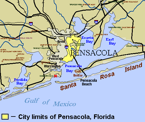
Geography
Pensacola is located on the north side of Pensacola Bay. It is 59 mi east of Mobile, Alabama, and 196 mi west of Tallahassee, the capital of Florida. Although the incorporated city limits of Pensacola are relatively small, numerous census-designated places (CDPs) are located immediately outside of the incorporated city limits that are widely considered to be Pensacola. Due to their proximity to the city limits, their mailing addresses are listed as Pensacola, with a lack of independent government services apart from the City of Pensacola and Escambia County. While residents of these CDPs have rejected incorporation into the City of Pensacola in previous referendums, they largely identify as residents of Pensacola. Examples of these CDPs include Goulding, Ferry Pass, Ensley, Bellview, Myrtle Grove, Warrington, Brent, and West Pensacola.
According to the United States Census Bureau, the city has a total area of 41.127 sqmi, of which 22.773 sqmi is land and 18.354 sqmi, or 44.62%, is water.
The land is sloped up northward from Pensacola Bay, with most of the city at an elevation above that at which a potential hurricane storm surge could affect.
Climate
Weather statistics since the late 20th century have been recorded at the airport. The city has seen single-digit temperatures (below 10 F) on three occasions: 5 °F on January 21, 1985; 7 °F on February 13, 1899; and 8 °F on January 11, 1982. According to the Köppen climate classification system, Pensacola has a humid subtropical climate (Köppen: Cfa), with short, mild winters and hot, humid summers. Typical summer conditions have highs in the lower 90s °F (32–34 °C) and lows in the mid-70s °F (23–24 °C). Afternoon or evening thunderstorms are common during the summer months. Due partly to the coastal location, temperatures above 100 °F are relatively rare and last occurred in June 2011, when two of the first four days of the month recorded highs reaching the century mark. The highest temperature ever recorded in the city was 106 °F on July 14, 1980.
In the 1991–2020 climate normals, the daily average temperature in January is 53.2 °F. Freezing temperatures occur an average of 11 days per winter, with the average first and last dates for a freeze being December 12 and February 14, giving Pensacola an average growing season of 301 days. However, the relatively recent winter season of 2018-19 did not record a freeze, the median first and last freeze dates are earlier and later than the averages of December 12 and February 14, and the median number of freezes per season is 11 or fewer. The mean coldest temperature reached in a given winter season is about 24 °F, although the median is slightly higher, at no colder than 25 °F most years, placing Pensacola in USDA zone 9b. Temperatures below 20 °F are very rare and last occurred on January 8, 2015, when a low of 19 °F was seen. The lowest temperature ever recorded in the city was 5 °F on January 21, 1985.
Snow is rare in Pensacola, but does occasionally fall. The most recent snowfall event occurred on January 21, 2025, which produced record-breaking accumulations of up to 9.4 in within the city limits and near-blizzard conditions. The snow event previous to it occurred on December 9, 2017. The city receives 68.31 in of precipitation per year, with a slightly more rainy season in the summer. The rainiest month is July, with 7.89 in, with May being the driest month at 3.90 in. In June 2012 over one foot (300 mm) of rain fell on Pensacola and adjacent areas, leading to widespread flooding. On April 29, 2014, Pensacola was drenched by at least 20 inches of rain within a 24-hour period, causing the worst flooding in 30 years.
The city suffered a major blow on February 23, 2016, when a large EF3 wedge tornado hit the northwest part of Pensacola, causing major damage and several injuries.
|Jan record high F = 81 |Feb record high F = 84 |Mar record high F = 90 |Apr record high F = 96 |May record high F = 102 |Jun record high F = 102 |Jul record high F = 106 |Aug record high F = 105 |Sep record high F = 102 |Oct record high F = 97 |Nov record high F = 89 |Dec record high F = 81 |year record high F = 106 |Jan avg record high F = 74.9 |Feb avg record high F = 77.4 |Mar avg record high F = 82.5 |Apr avg record high F = 85.2 |May avg record high F = 92.6 |Jun avg record high F = 95.7 |Jul avg record high F = 97.0 |Aug avg record high F = 96.2 |Sep avg record high F = 94.8 |Oct avg record high F = 88.9 |Nov avg record high F = 82.3 |Dec avg record high F = 77.6 |year avg record high F = 98.4 |Jan avg record low F = 25.7 |Feb avg record low F = 30.2 |Mar avg record low F = 35.1 |Apr avg record low F = 44.0 |May avg record low F = 54.1 |Jun avg record low F = 66.7 |Jul avg record low F = 70.4 |Aug avg record low F = 69.2 |Sep avg record low F = 60.3 |Oct avg record low F = 44.6 |Nov avg record low F = 34.1 |Dec avg record low F = 30.5 |year avg record low F = 24.1 |Jan record low F = 5 |Feb record low F = 7 |Mar record low F = 22 |Apr record low F = 33 |May record low F = 44 |Jun record low F = 55 |Jul record low F = 61 |Aug record low F = 60 |Sep record low F = 43 |Oct record low F = 32 |Nov record low F = 22 |Dec record low F = 11 |year record low F = 5
Hurricanes

Pensacola's location on the Florida Panhandle makes it vulnerable to hurricanes. Hurricanes which have made landfall at or near Pensacola since the late 20th century include Eloise (1975), Frederic (1979), Juan (1985), Erin (1995), Opal (1995), Georges (1998), Ivan (2004), Dennis (2005), and Sally (2020). In July 2005, Hurricane Dennis made landfall just east of the city, sparing it the damage received from Ivan the year before. However, hurricane and near-hurricane-force winds were recorded in downtown, causing moderate damage.
Pensacola received only a glancing blow from Hurricane Katrina in 2005, resulting in light to moderate damage reported in the area. The aftermath of the extensive damage from Katrina was a dramatic reduction in tourism coming from Louisiana, Mississippi, and Alabama.
Hurricane Ivan
Main article: Hurricane Ivan
On September 16, 2004, Pensacola and several surrounding areas were devastated by Hurricane Ivan. Pensacola was on the eastern side of the eyewall, which sent a large storm surge into Escambia Bay; this destroyed most of the I-10 Escambia Bay Bridge. The storm knocked 58 spans off the eastbound and westbound bridges and misaligned another 66 spans, forcing the bridge to close to traffic in both directions. The surge also destroyed the fishing bridge that spanned Pensacola Bay alongside the Phillip Beale Memorial Bridge, locally known as the Three Mile Bridge.
Over $6 billion in damage occurred in the metro area and more than 10,000 homes were destroyed, with another 27,000 heavily damaged. 105,000 households in Northwest Florida were impacted in some way by the storm, and 4,300 businesses in the area permanently closed as a result of Hurricane Ivan. NASA created a comparison image to illustrate the massive damage. This widespread destruction of property caused a temporary lack of affordable housing in the Pensacola real estate market, and Hurricane Dennis and Hurricane Katrina contributed to a general scarcity of construction labor and resources along the Gulf Coast.
Hurricane Sally
Main article: Hurricane Sally
In September 2020, Pensacola suffered heavy damage from Hurricane Sally. Damages in Escambia County were estimated by local officials at $29 million. Downtown Pensacola was flooded.
Demographics
|align-fn=center 2020 Census
As of the 2023 American Community Survey, there are 24,979 estimated households in Pensacola with an average of 2.14 persons per household. The city has a median household income of $72,699. Approximately 12.4% of the city's population lives at or below the poverty line. Pensacola has an estimated 61.6% employment rate, with 42.7% of the population holding a bachelor's degree or higher and 92.7% holding a high school diploma.
The top five reported ancestries (people were allowed to report up to two ancestries, thus the figures will generally add to more than 100%) were English (93.7%), Spanish (2.3%), Indo-European (1.9%), Asian and Pacific Islander (1.8%), and Other (0.3%) .
The median age in the city was 40.8 years.
2020 census
| Race / ethnicity (NH = non-Hispanic) | title=P004: Hispanic or Latino, and Not Hispanic or Latino by Race – 2000: DEC Summary File 1 – Pensacola city, Florida | url=https://data.census.gov/table?g=160XX00US1255925&tid=DECENNIALSF12000.P004 | publisher=United States Census Bureau | access-date=January 22, 2025 }} | title=P2: Hispanic or Latino, and Not Hispanic or Latino by Race – 2010: DEC Redistricting Data (PL 94-171) – Pensacola city, Florida | url=https://data.census.gov/table?q=p2&g=160XX00US1255925&tid=DECENNIALPL2010.P2 | publisher=United States Census Bureau | access-date=January 22, 2025 }} | % 2000 | % 2010 |
|---|---|---|---|---|---|---|---|---|---|---|
| White alone (NH) | 35,824 | 33,383 | 35,105 | 63.68% | ||||||
| Black or African American alone (NH) | 17,086 | 14,420 | 12,054 | 30.37% | ||||||
| Native American or Alaska Native alone (NH) | 282 | 269 | 194 | 0.50% | ||||||
| Asian alone (NH) | 991 | 1,024 | 1,290 | 1.76% | ||||||
| Pacific Islander alone (NH) | 31 | 62 | 43 | 0.06% | ||||||
| Other race alone (NH) | 79 | 58 | 269 | 0.14% | ||||||
| Mixed race or multiracial (NH) | 795 | 996 | 2,519 | 1.41% | ||||||
| Hispanic or Latino (any race) | 1,167 | 1,711 | 2,838 | 2.07% | ||||||
| Total | 56,255 | 51,923 | 54,312 | 100.00% |
As of the 2020 census, there were 54,312 people, 24,748 households, and 13,470 families residing in the city. The population density was 2395.7 PD/sqmi. There were 27,892 housing units at an average density of 1230.3 /sqmi. The racial makeup of the city was 66.16% White, 22.41% African American, 0.43% Native American, 2.47% Asian, 0.09% Pacific Islander, 1.39% from some other races and 7.05% from two or more races. Hispanic or Latino people of any race were 5.23% of the population.
2010 census
As of the 2010 census, there were 51,923 people, 23,592 households, and _ families residing in the city. The population density was 2303.5 PD/sqmi. There were 26,848 housing units at an average density of 1191.1 /sqmi. The racial makeup of the city was 66.34% White, 27.98% African American, 0.56% Native American, 2.00% Asian, 0.12% Pacific Islander, 0.70% from some other races and 2.30% from two or more races. Hispanic or Latino people of any race were 3.30% of the population.
2000 census
As of the 2000 census, there are 56,255 people, 24,524 households, and 14,665 families residing in the city. The population density was 2478.7 PD/sqmi. There are 26,995 housing units at an average density of 1189.4 /sqmi. The racial makeup of the city was 64.91% White, 30.58% African American, 0.52% Native American, 1.77% Asian, 0.06% Pacific Islander, 0.54% from some other races and 1.61% from two or more races. Hispanic or Latino people of any race were 2.07% of the population.
There were 24,524 households out of which 24.6% have children under the age of 18 living with them, 39.7% are married couples living together, 16.7% have a female householder with no husband present, and 40.2% are non-families. 32.9% of all households are made up of individuals and 11.7% have someone living alone who is 65 years of age or older. The average household size is 2.27 and the average family size is 2.92.
In the city the age distribution was 22.9% under the age of 18, 8.9% from 18 to 24, 26.9% from 25 to 44, 24.0% from 45 to 64, and 17.2% who were 65 years of age or older. The median age was 39 years. For every 100 females there were 88.5 males. For every 100 females age 18 and over, there were 84.7 males.
The median income for a household in the city was $34,779, and the median income for a family was $42,868. Males had a median income of $32,258 versus $23,582 for females. The per capita income for the city was $21,438. 16.1% of the population and 12.7% of families were below the poverty line. Out of the total people living in poverty, 26.2% were under the age of 18 and 9.2% were 65 or older.
1860 census
Pensacola was Florida's largest city in 1860, with a population of 2,876.
1850 census
Pensacola's first appearance in the U.S. Census dataset was in 1850, with a total recorded population of 2,164.
Economy

Military
The city has been referred to as "the Cradle of Naval Aviation". Naval Air Station Pensacola (NASP) was the first naval air station commissioned by the U.S. Navy in 1914. Tens of thousands naval aviators have received their training there, including John H. Glenn, USMC, who became the first American to orbit the Earth in 1962, and Neil Armstrong, who became the first man to set foot on the Moon in 1969. The Navy's Flight Demonstration Squadron, the Blue Angels, is stationed there.
The National Museum of Naval Aviation is located on NASP and is free to the public. The museum cares for and exhibits hundreds of vintage naval-aviation aircraft and preserves the history of naval aviation through displays, symposiums, IMAX movies, and tours.
Information Warfare Training Command Corry Station serves as an annex for the main base and the Center for Information Warfare Training Command. CWO3 Gary R. Schuetz Memorial Health Clinic is at Corry Station, Naval Hospital Pensacola, as is the main Navy Exchange and Defense Commissary Agency commissary complex for both Corry Station and NAS Pensacola. The Army National Guard B Troop 1-153 Cavalry, Bravo Company 146th Expeditionary Signal Battalion, is stationed in Pensacola.
NASP hosted the commissioning ceremony of the United States Navy's newest amphibious transport dock, the USS Richard M. McCool Jr. (LPD 29) on September 7, 2024. The ceremony featured Shana McCool, the granddaughter of Richard M. McCool Jr.; Shana served as the ship's sponsor. Notable attendees included the secretary of the Navy and the chief of naval operations. LPD 29 is the 13th ship of the San Antonio-class to be commissioned in the United States Navy and is the first vessel to be the namesake of Richard M. McCool Jr.
Tourism
Pensacola is home to a number of annual festivals, events, historic tours, and landmarks. The Pensacola Seafood Festival and the Pensacola Crawfish Festival have been held for nearly 30 years in the city's historic downtown. The Great Gulfcoast Arts Festival is held annually in November in Seville Square, and often draws more than 200 regional and international artists. The Children's Art Festival, also held in Seville Square, displays art by local schoolchildren. Pensacon is a comic convention held each February, with nearly 25,000 attendees from around the world. The Pensacola Interstate Fair is held each fall.
Scuba diving and deep-sea fishing are a large part of Pensacola's tourism industry. The USS Oriskany was purposefully sunk in 2004 to create an artificial reef off the shores of Pensacola.
Several walking tours of restored 18th-century-era neighborhoods are in Pensacola.
Pensacola is the site of the Vietnam Veterans' Wall South. The city has a number of historical military installations from the Civil War, including Fort Barrancas. Fort Pickens served as a temporary prison for Geronimo. Other military landmarks there include the National Naval Aviation Museum and Pensacola Lighthouse at NAsP.
The city's convention and visitors' bureau, Visit Pensacola, is overseen by the Greater Pensacola Chamber.
Top employers
| Rank | Employer | Employees |
|---|---|---|
| 1 | Navy Federal Credit Union | 7,723 |
| 2 | Baptist Health Care | 6,633 |
| 3 | Sacred Heart Health Systems | 4,820 |
| 4 | Florida Power And Light | 1,774 |
| 5 | West Florida Healthcare | 1,200 |
| 6 | Ascend Performance Materials | 888 |
| 7 | Alorica (fka West Corporation) | 800 |
| 8 | Innisfree Hotels | 750 |
| 9 | Santa Rosa Medical Center | 521 |
| 10 | Medical Center Clinic | 500 |
Arts and culture
The arts and theatre

There are a number of performance venues in the Pensacola area, including the Pensacola Bay Center (formerly the Pensacola Civic Center), often used for big-ticket events, and the Saenger Theater, used for performances and mid-level events. Other theatres used for live performances, plays, and musicals include the Pensacola Little Theatre, Pensacola State College, University of West Florida, Vinyl Music Hall, and Loblolly Theatre. Pensacola is also home to the Pensacola Opera, Pensacola Children's Chorus, Pensacola Symphony Orchestra, Pensacola Civic Band, Pensacola Bay Concert Band, and the Choral Society of Pensacola, as well as Ballet Pensacola, as well as the Palafox Place entertainment district.
Architecture

Pensacola does not have a prominent skyline, but has several low-rise buildings. The tallest is the 15-floor Crowne Plaza Grand Hotel, at 146 ft. Other tall buildings include the Scenic Apartments (98 ft), SunTrust Tower (96 ft), Seville Tower (88 ft), and the AT&T Building (76 ft).
Historic buildings in Pensacola include the First National Bank Building.
Museums
- Historic Pensacola's Museum of Commerce
- Museum of Industry
- National Naval Aviation Museum
- Pensacola MESS Hall
- Pensacola Museum of Art
Pelican Drop
The Pelican Drop was a New Year's Eve celebration that took place each year in downtown Pensacola. At the ceremony, an aluminum pelican, the city's mascot, was dropped instead of the typical New Year's ball. The event included live music and fireworks. From 2008 to 2018, The Pelican Drop was a significant attraction in the area, drawing in crowds of up to 50,000 local residents and visitors, making it one of the largest events of its kind in the Central Time Zone. In 2014, the event was named as one of the top-20 events in the Southeast by the Southeast Tourism Society.
History
The First Pelican Drop New Year's Celebration took place in 2008. The Pensacola News Journal released an article stating that the Pensacola Community Redevelopment Agency was planning a new kind of New Year's Eve celebration, to be held at the Plaza Ferdinand VII and broadcast live on WEAR-TV; beginning with the 2017 celebration, events were carried in simulcast on WEAR's website. Almost 45,000 people showed up for the event, including residents of Mobile, Alabama (which hosts its own competing drop, a Moon Pie), Milton, Florida, Navarre, Florida, and Destin, Florida.
In December 2019, organizers announced that the Pelican Drop had been canceled due to financial issues and the burden the event had caused on local police and public services. A smaller fireworks display, which does not require the same amount of traffic disruption, would be held, instead.
The pelican was made and designed by Emmett Andrews LLC. Made of polished aluminum and decorated with over 2,000 lights, the bird had a 17 ft wingspan and is 12 ft high.
Sports
Notable sports teams in Pensacola include:
| Pensacola Roller Gurlz | Flat Track Roller Derby | Women's Flat Track Derby Association | Dreamland Skate Center |
|---|
Previously, the Pensacola Pelicans was an independent league baseball team that played at Jim Spooner Field from 2002 to 2010.
The city hosted professional golf tournaments such as the Pensacola Open (PGA Tour, 1958–1988), the Pensacola Ladies Invitational (LPGA Tour, 1965–1968) and Pensacola Classic (Nike Tour, 1990–1995).
America's Cup team American Magic call Pensacola their home port until the 2024 America's Cup commences.
The Five Flags Speedway is a half-mile paved racetrack that opened in 1953. It hosts the Snowball Derby stock car race every December since 1968. It has also hosted rounds of the NASCAR Grand National (now NASCAR Cup Series), Superstar Racing Experience, NASCAR Southeast Series, ARCA Racing Series, ARCA Menards Series East, ASA National Tour, CARS Pro Cup Series and Southern Super Series.
Parks and recreation
- Gulf Islands National Seashore
- Big Lagoon State Park - approximately 10 mile southwest of Pensacola on Gulf Beach Highway
- Perdido Key State Park - located on a barrier island 15 mile southwest of Pensacola, off S.R. 292
- Tarkiln Bayou Preserve State Park - 10 mile southwest of Pensacola,
- Pensacola Bayfront Stadium - a multi-use park in Pensacola
- Plaza Ferdinand VII
- Bayview Park
- Miraflores Park
Government
| District | Council member |
|---|---|
| 1 | Jennifer Brahier |
| 2 | Charles Bare |
| 3 | Casey Jones |
| 4 | Jared Moore |
| 5 | Teniade Broughton |
| 6 | Allison Patton |
| 7 | Delarian Wiggins |
The city of Pensacola utilizes a strong mayor-council form of government, which was adopted in 2011 after citizens voted in 2009 to approve a new city charter. An elected mayor serves as the chief executive of the city government, while a seven-member city council serves as the city's governing body. A council president is selected by the council from its members, along with a vice president.
City voters approved a charter amendment on June 11, 2013, which eliminated the then-nine member council's two at-large seats; one seat was phased out in November 2014, and the other expired in November 2016. Two additional charter amendments were approved on November 4, 2014, which made the position of mayor subject to recall and provided the city council with the authority to hire staff. The current city hall was opened in 1986.
Politics
After the Civil War, Pensacola, like the rest of the South, was controlled by Republicans during the Reconstruction era (1865-1877). The Republican government had numerous African American politicians, including several county commissioners, city aldermen, constables, state representatives, and even one African American mayor—Salvador Pons. However, with the 1884 election of native Pensacolian and former Confederate general Edward Perry, a dramatic shift occurred. Perry, a Democrat who actually lost the Escambia County vote during the statewide election, acted to dissolve the Republican city government of Pensacola and in 1885 replaced this government with hand-picked successors, including railroad magnate William D. Chipley. The only African American to remain in city government was George Washington Witherspoon, a pastor with the African Methodist Episcopal Church who was previously a Republican and switched parties to the Democrats. Following Governor Perry's dissolution of the Republican government, the city remained Democratic for more than a century after the Civil War with no African Americans serving in an elected capacity for nearly a century.
| Year | Democratic | Republican | Others |
|---|---|---|---|
| 2020 | 51.5% 18,181 | 46.4% 16,356 | 2.1% 751 |
| 2016 | 46.7% 15,183 | 47.3% 15,386 | 6.1% 1,974 |
This changed in 1994, when Republican attorney Joe Scarborough defeated Vince Whibbs Jr., the son of popular former Democratic mayor Vince Whibbs, in a landslide to represent , which is based in Pensacola. Republicans also swept all of the area's seats in the state legislature, the majority of which were held by Democrats. Since then, Republicans have dominated every level of government, although municipal elections are officially nonpartisan.
Regional representatives
Pensacola is represented in the United States House of Representatives by Jimmy Patronis (R), who won the seat in a special election following the resignation of Matt Gaetz (R) in November 2024. It is represented in the state senate by Doug Broxson (R) and in the state house by District 2 representative Alex Andrade (R).
Education
The main campus of Pensacola State College is in the City of Pensacola. The University of West Florida (UWF) operates a campus in downtown Pensacola. Its main campus, located north of the city, has the largest library in the region, the John C. Pace Library. UWF is the largest post-secondary institution in the area.
Public primary and secondary schools in Pensacola are administered by the Escambia County School District. The district operates two high schools (Booker T. Washington and Pensacola) within the City of Pensacola. District-run high schools near the city include Escambia, J. M. Tate, and Pine Forest. Other public schools in the city include A.K. Suter Elementary, Cordova Park Elementary, J.H. Workman Middle, N.B. Cook Elementary, O.J. Semmes Elementary, and Scenic Heights Elementary. The district also operates one magnet high school (West Florida High School of Advanced Technology) near the city.
Several private schools operate within or near the city: East Hill Academy, East Hill Christian School, Episcopal Day School of Christ Church, Pensacola Catholic High School, Pensacola Christian Academy, Sacred Heart Cathedral School, Saint John the Evangelist Catholic School, Saint Paul Catholic School, Little Flower Catholic School, and Seville Bayside Montessori. The campus of Pensacola Christian College is near the city.
Media
Main article: Escambia County, Florida media
The largest daily newspaper in the area is the Pensacola News Journal, with offices on Romana Street in downtown; the News Journal is owned by the Gannett Company. There is an alternative weekly newspaper, Inweekly.
Pensacola is home to WEAR-TV, which is a dual affiliate of ABC and NBC for Pensacola, Navarre, Fort Walton Beach, and Mobile, Alabama, and WSRE-TV, the local PBS member station, which is operated by Pensacola State College. Other television stations in the market include WALA-TV, the Fox affiliate; WKRG, the CBS affiliate; and WPMI, a de facto owned-and-operated station of the Roar network, which are all located in Mobile. Cable service in the city is provided by Cox Communications and AT&T U-Verse. WUWF is the area's NPR member station and is based at the University of West Florida. WPCS (FM) is broadcast from the Pensacola Christian College campus, where the nationwide Rejoice Radio Network maintains its studio.
Pensacola Magazine, the city's monthly glossy magazine, and Northwest Florida's Business Climate, the only business magazine devoted to the region, are published locally. The News Journal also publishes Home & Garden Weekly magazine as well as the monthly Bella, devoted to women.
Infrastructure
Transportation===

Aviation
Major air traffic in the Pensacola and greater northwest Florida area is handled by Pensacola International Airport. , airlines serving Pensacola International Airport are American Airlines, Delta Air Lines, Frontier Airlines, Silver Airways, Southwest Airlines, Spirit Airlines, and United Airlines.
Railroads
Pensacola was first connected by rail with Montgomery, Alabama, via the Alabama and Florida Railroad, completed in 1861 just before the start of the Civil War. During the war, most of the rails between Pensacola and the Alabama state line were removed to construct other railroad lines urgently needed elsewhere in the Confederacy. The line to Pensacola was not rebuilt until 1868, and was acquired by the Louisville and Nashville Railroad in 1880. In 1882, the Pensacola and Atlantic Railroad was completed from Pensacola to Chattahoochee, Florida, linking Pensacola with the rest of the state. This line was also acquired by the L&N.
By 1928, a number of short lines built northward from Pensacola to Kimbrough, Alabama, were acquired by the Frisco Railroad, giving it access to the port of Pensacola. Some thirty years later, retired Frisco steam engine 1355 was donated to the city and stands in the median of Garden Street, near the site of the now-demolished Frisco passenger station.
Frisco passenger service to Pensacola ended in 1955, and L&N passenger service, including the streamlined Gulf Wind, ended in 1971 with the advent of Amtrak. However, from early 1993 through August 2005 Pensacola was served by the tri-weekly Amtrak Sunset Limited, but service east of New Orleans to Jacksonville and Orlando was suspended due to damage to the rail line of CSX during Hurricane Katrina in 2005.
In the 21st century, freight service to and from Pensacola is provided by L&N successor CSX as well as Frisco successor Alabama and Gulf Coast Railway, a short line. On June 1, 2019, the newly formed Florida Gulf & Atlantic Railroad, a Class III railroad headquartered in Tallahassee, acquired the CSX main line from Pensacola to Baldwin, Florida, near Jacksonville, becoming the Panhandle's only east–west freight hauler. A news report on the new railroad in mid-2019 noted that Amtrak indicated that the Panhandle had a "near-zero chance" of seeing passenger service restored. Pensacola and Tallahassee are the two largest metropolitan areas in Florida without any passenger rail service.
Major highways
- [[File:I-10.svg|20px]] Interstate 10
- [[File:I-110.svg|20px]] Interstate 110
- [[File:US 29.svg|20px]] U.S. Route 29
- [[File:US 90.svg|20px]] U.S. Route 90 & U.S. Route 90 Alternate
- [[File:US 98.svg|20px]] U.S. Route 98 & U.S. Route 98 Business
- [[File:Florida 289.svg|23px]] State Road 289 Ninth Avenue
- [[File:Florida 291.svg|23px]] State Road 291 Davis Highway
- [[File:Florida 292.svg|23px]] State Road 292 Pace Boulevard
- [[File:Florida 295.svg|23px]] State Road 295 New Warrington Road, Farfield Drive
- [[File:Florida 296.svg|23px]] State Road 296 Michigan Avenue, Beverly Parkway, Brent Lane, Bayou Boulevard, Perry Street
- [[File:Florida 742.svg|23px]] State Road 742 Creighton Road, Burgess Road
- [[File:Florida 750.svg|23px]] State Road 750 Airport Boulevard
Mass transit
The local bus service is the Escambia County Area Transit. ECAT operates fixed route bus service and paratransit service. The ECAT system currently provides fixed-route bus service, as well as the seasonal Pensacola Beach trolley and University of West Florida on-campus trolley. The app can be downloaded from this site, which also shows the service area and lists the routes.
Pensacola also has a ferry service owned by the National Park Service. It has stops in Downtown Pensacola, Pensacola Beach and Fort Pickens.
Bus
The city is served by Greyhound Bus and Greyhound Lines.
Hospitals
Hospitals in Pensacola include Ascension Sacred Heart Hospital, Baptist Hospital, Encompass Health Rehabilitation Hospital, HCA Florida West Hospital, and Select Specialty Hospital.
Notable people
Main article: List of people from Pensacola, Florida
Bands from Pensacola
- Finite Automata, an industrial band
- This Bike is a Pipe Bomb, a folk-punk band
- Twothirtyeight, indie rock band
- Body Head Bangerz, hip hop group
- McAlyster, country music group
Sister cities
Pensacola's sister cities are:
- PER Chimbote, Peru
- CRI Escazú, Costa Rica
- JPN Gero, Japan
- MEX Isla Mujeres, Mexico
- UKR Horlivka, Ukraine
- PER Miraflores, Peru
- TWN Kaohsiung, Taiwan
- ESP Macharaviaya, Spain
References
References
- "New Logo, Brand: Welcome To Pensacola, The Upside Of Florida : NorthEscambia.com".
- "City Council". City of Pensacola, Florida.
- (December 2020). "Florida Cities by Incorporation Year with Incorporation & Dissolution Info". Florida League of Cities (FLC).
- "2024 U.S. Gazetteer Files". United States Census Bureau.
- (December 29, 2022). "2020 Census Qualifying Urban Areas and Final Criteria Clarifications". United States Census Bureau.
- {{GNIS. 2404503
- "Explore Census Data". [[United States Census Bureau]].
- "Tristan de Luna y Arellano {{!}} University of West Florida".
- "Emanuel Point Shipwreck".
- Worth, John E.. "The Tristán de Luna Expedition, 1559-1561".
- Howard, Clinton N.. (March 5, 1947). "The British Development of West Florida: 1763–1769". University of California Publications in History.
- Swanton, John Reed. (2003). "The Indian tribes of North America". Genealogical Publishing.
- Dean R. Snow, ''Archaeology of Native North America'' (2010), New York: Prentice-Hall. pp. 248–249
- (2007). ""History" (Luna colony at Ochuse/Pensacola)". State of Florida, Office of Cultural & Historical Programs.
- Davis, Jack E.. (2017). "The Gulf: The Making of an American Sea". Liveright.
- John E. Worth, The Tristán de Luna Expedition, 1559–1561, http://uwf.edu/jworth/spanfla_luna.htm {{Webarchive. link. (June 30, 2016)
- Johnson, Jane. "Santa Rosa Island - a History (Part 1)".
- Pinson, Steve. "The Tristan de Luna Expedition". Pensacola Archeology Lab.
- (2005). "Floripedia: Pensacola, Florida". [[University of South Florida]].
- (2003). "Presidio Isla de Santa Rosa". [[University of West Florida]].
- Gene Allen Smith, Texas Christian University. "Sanctuary in the Spanish Empire: An African American officer earns freedom in Florida". National Park Service.
- John Richard Alden. (1957). "The South in the Revolution, 1763–1789". Louisiana State University Press.
- (1991). "Florida from the Beginning to 1992 : a Columbus Jubilee Commemorative". Pioneer Publications.
- Dysart, Jane E.. (1982). "Another Road to Disappearance: Assimilation of Creek Indians in Pensacola, Florida, during the Nineteenth Century". The Florida Historical Quarterly.
- "St. Michael's Cemetery Foundation of Pensacola, Inc".
- "Museum of Florida History".
- (2012). "By the noble daring of her sons : the Florida Brigade of the Army of Tennessee". University of Alabama Press.
- (April 7, 2017). "A century ago, martial law shuttered Pensacola as streetcars were bombed, militia took over city". The Pulse.
- Flynt, Wayne. (1965). "Pensacola Labor Problems and Political Radicalism, 1908". The Florida Historical Quarterly.
- "Story Map Series".
- "STORM2K - South Florida Cold Snap Is Overhyped - Much Warmer".
- "Pensacola, Florida Köppen Climate Classification (Weatherbase)". Weatherbase.
- "Monthly Averages for Pensacola, Fla.". The Weather Channel.
- "History for Pensacola, Florida on Wednesday, June 1, 2011". Weather Underground.
- Team, National Weather Service Corporate Image Web. "National Weather Service Climate".
- "History for Pensacola, Florida on Tuesday, January 7, 2014". Weather Underground.
- "Historic January 21, 2025 Snowstorm".
- "KMOB Winter Storm Warning #1".
- "Past Weather in Pensacola, Florida USA - December 2017?". CustomWeather Monitor.
- (June 10, 2012). "Floods, Water Rescues Along Gulf Coast". weather.com.
- (April 30, 2014). "'Life-Threatening' Flooding Submerges Pensacola, Florida". [[NBC News]].
- "Tornado aftermath: 300+ homes destroyed, damaged". Pensacola News Journal.
- "NowData – NOAA Online Weather Data". National Oceanic and Atmospheric Administration.
- "Station: Pensacola RGNL AP, FL". National Oceanic and Atmospheric Administration.
- "Powerful Hurricane Ivan Slams the Central Gulf Coast as a Category 3 Hurricane". United States Department of Commerce.
- "Repairing Florida's Escambia Bay Bridge". ACP Construction.
- "Bridge Replacement over Escambia Bay". Florida Department of Transportation.
- (September 23, 2014). "Ivan Turned Gulf Coast Real Estate Upside Down".
- "Hurricane Sally a 'major disaster' but no individual assistance coming without public's help". [[Pensacola News Journal]].
- "City and Town Population Totals: 2020-2023". United States Census Bureau.
- "Decennial Census of Population and Housing". United States Census Bureau.
- "U.S. Census Bureau QuickFacts: Pensacola city, Florida".
- "P004: Hispanic or Latino, and Not Hispanic or Latino by Race – 2000: DEC Summary File 1 – Pensacola city, Florida". [[United States Census Bureau]].
- "P2: Hispanic or Latino, and Not Hispanic or Latino by Race – 2010: DEC Redistricting Data (PL 94-171) – Pensacola city, Florida". [[United States Census Bureau]].
- "P2: Hispanic or Latino, and Not Hispanic or Latino by Race – 2020: DEC Redistricting Data (PL 94-171) – Pensacola city, Florida". [[United States Census Bureau]].
- "US Census Bureau, Table P16: Household Type". United States Census Bureau.
- "How many people live in Pensacola city, Florida". [[USA Today]].
- "1860 Census of Population: Florida".
- "1850 Census of Population: Florida".
- "About".
- "Naval Air Station Pensacola Base Guide".
- "USS Richard M. McCool, Jr. Commissions".
- (September 8, 2024). "USS Richard M. McCool Commissioning CNO Remarks".
- "The Pensacola Interstate Fair".
- Edlund, Martin. (May 6, 2006). "You Sank My Tourist Attraction!". [[The Wall Street Journal]].
- "Official Tourism Website of Pensacola, Florida".
- "Greater Pensacola Chamber - Home".
- "TOP EMPLOYERS". floridawesteda.com.
- "Civic Center renamed "Pensacola Bay Center" {{!".
- "Visit South No Longer Exists But Travel Sweepstakes Are Still Here".
- Beninate, Renee. (December 30, 2019). "Fireworks, but no Pelican Drop, for this year's NYE celebration in downtown Pensacola".
- Ross, Rebecca. (December 7, 2008). "Build-a-bird". Pensacola News Journal.
- Scheurich, Hal. (December 31, 2010). "Pensy Pelican readies for New Year drop". Fox10 TV.
- (October 13, 2006). "Big Lagoon State Park Unit Management Plan". STATE OF FLORIDA DEPARTMENT OF ENVIRONMENTAL PROTECTION.
- "Perdido Key State Park".
- "Tarkiln Bayou Preserve State Park".
- (2007). "HUNTER AMPHITHEATRE".
- "Bayview Park". City of Pensacola.
- "Miraflores Park". City of Pensacola.
- "Senator Broxson - The Florida Senate".
- "Florida House of Representatives - Robert Alexander "Alex" Andrade - 2018 - 2020 (Speaker Oliva)".
- "About Us". Pensacola Christian College.
- (2019). "Airlines".
- (January 1926). "Frisco Will Spend $2,500,000 in Rehabilitating Pensacola Road". The Frisco Employes' Magazine.
- (August 1928). "The Frisco Meets the Gulf". The Frisco Employes' Magazine.
- "History".
- "Amtrak - Error".
- (July 29, 2019). "Florida Gulf And Atlantic Assumes Ownership of North Florida Rail Line". WFSU.org.
- "Mass Transit/ECAT Authority". Escambia County, Florida.
- "Trip Planner". ECAT.
- "Moovit App for ECAT". ECAT.
- "Pensacola station". Greyhound.com.
- "List of Facilities". Florida Agency for Health Care Administration.
- (July 25, 2018). "How to help Pensacola's Japanese Sister City devastated by flooding". Pensacola News Journal.
This article was imported from Wikipedia and is available under the Creative Commons Attribution-ShareAlike 4.0 License. Content has been adapted to SurfDoc format. Original contributors can be found on the article history page.
Ask Mako anything about Pensacola, Florida — get instant answers, deeper analysis, and related topics.
Research with MakoFree with your Surf account
Create a free account to save articles, ask Mako questions, and organize your research.
Sign up freeThis content may have been generated or modified by AI. CloudSurf Software LLC is not responsible for the accuracy, completeness, or reliability of AI-generated content. Always verify important information from primary sources.
Report