From Surf Wiki (app.surf) — the open knowledge base
Pawtuckaway State Park
Preserve in New Hampshire, United States

Preserve in New Hampshire, United States
| Field | Value |
|---|---|
| name | Pawtuckaway State Park |
| iucn_category | V |
| photo | Pawtuckaway campsite.JPG |
| map | USA New Hampshire |
| map_size | 200 |
| map_caption | Location within New Hampshire |
| relief | 1 |
| location | Nottingham, Deerfield, Rockingham County, New Hampshire, United States |
| coordinates | |
| area_km2 | 22.22 |
| website | Pawtuckaway State Park |
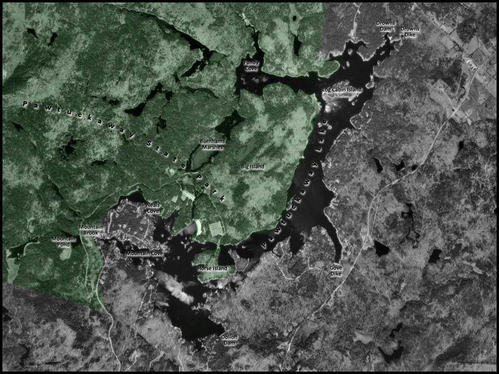
Pawtuckaway State Park is a 5000 acre preserve in New Hampshire, United States. It is one of the largest state parks in southeastern New Hampshire and is named for Pawtuckaway Lake and the Pawtuckaway Mountains. The park extends from the west shore of the lake to the west side of the mountains.
Geology
The Pawtuckaway Mountains are a small, rocky, circular range that form the outline of an ancient volcanic ring dike{{cite journal |url-status = dead |archive-url = https://web.archive.org/web/20110725051300/http://www.bear-paw.org/uploads/pdf/Bear-Paw%20Print%20Fall%202003.pdf |archive-date = 2011-07-25 |access-date=2008-10-16 |access-date=2008-10-18
Earthquakes occurred in the vicinity of the ring dike in the summer and fall of 1845. Known as the Deerfield explosions, they were described as subterranean noises "often as loud as the report of a 12 pounder cannon when heard at a distance of half a mile" but without echoes.{{cite book
Environment
The park lies within the Northeastern coastal forests ecoregion.
Recreation
The park has 32 mi of hiking trails. Trails lead to the approximately 900 ft summits of North and South Pawtuckaway mountains and connect the ring dike area to the lake. Other hiking trails lead to ponds, boulder fields, and views of the lake. Some of the hiking trails are used in the winter as snowmobile routes. The Pawtuckaway ring dike includes a boulder field of interest to boulderers,{{cite web |access-date=2008-10-18 |archive-date=October 24, 2008 |archive-url=https://web.archive.org/web/20081024120345/http://wiki.worldflicks.org/pawtuckaway_ring_dike.html |url-status=dead
The lake is a 783 acre water body with numerous islands and coves and is a popular boating, fishing, and swimming destination. Since orienteering enthusiasts made an orienteering map of the park in 1992,{{cite web |access-date=2008-10-14 |access-date=2008-10-09
Park amenities include 5 cabins, 195 campsites, a boat launch, a swimming beach, camp store, ball field, playground, bathhouse, shelters, picnic tables, and canoe, paddleboard, and kayak rentals.
History
The area was originally composed of many brooks which collected in low spots and formed small ponds, such as what was then known as Pawtuckaway Pond. Some of the brooks that ran through the area eventually ran into the Pawtuckaway River. Both the North River and the Pawtuckaway River then ran into the Lamprey River.
The construction of two colonial sawmills marked the beginning of enlarging the small ponds. On the north end, in 1729 a sawmill enlarged Pawtuckaway Pond. On the south end, in 1732 another sawmill enlarged Dolloff Pond.
Beginning in 1825 the Newmarket Manufacturing Company began to acquire land in the area for the construction of a reservoir to supply a consistent source of water power to its textile mill in nearby Newmarket, downstream from the lake. In 1836 two dams and several dikes were constructed that changed the features and character of the two ponds, causing their waters to merge except when the water levels were drawn down.
Eventually, steam power replaced water power, and gradually less water was drained from the lake to generate power. As water levels rose over time, Dolloff Pond and Pawtuckaway Pond merged into a single body of water. When the Newmarket Manufacturing Company fell on hard times in the early 1920s, it closed its mill in Newmarket. Its interests in the lake eventually passed into the hands of the New Hampshire Electric Company, which outfitted the dams with generators for hydroelectric power. Ultimately, the production of electricity became unprofitable and in December 1955 NH Electric deeded the lake, its islands, its adjacent land, two dams, the dikes, and the water rights to the State of New Hampshire. In 1958 Dolloff Pond was officially considered merged into Pawtuckaway Pond, and the level of the pond is now managed for recreational and environmental uses.
References
References
- [http://www.granit.sr.unh.edu New Hampshire GRANIT database] {{webarchive. link. (2013-08-03)
- Olson, D. M, E. Dinerstein. (2001). "Terrestrial Ecoregions of the World: A New Map of Life on Earth". [[BioScience]].
- Atkinson, Jay. (2020-06-18). "Where There's a Will, There's Pawtuckaway".
- [http://www.nhstateparks.org/explore/state-parks/pawtuckaway-state-park.aspx "Pawtuckaway State Park"], New Hampshire Division of Parks and Recreation
- "Archived copy".
- "A plan for the development of the state property at Pawtuckaway Lake." August 1958, p. 7 https://babel.hathitrust.org/cgi/pt?id=uiug.30112089645656&view=1up&seq=9
- [http://www.nottingham-nh.gov/Pages/NottinghamNH_Historic/townhistory Town of Nottingham, NH - Town History] {{webarchive. link. (2014-05-22)
- "A plan for the development of the state property at Pawtuckaway Lake." August 1958, p. 1 https://babel.hathitrust.org/cgi/pt?id=uiug.30112089645656&view=1up&seq=9
This article was imported from Wikipedia and is available under the Creative Commons Attribution-ShareAlike 4.0 License. Content has been adapted to SurfDoc format. Original contributors can be found on the article history page.
Ask Mako anything about Pawtuckaway State Park — get instant answers, deeper analysis, and related topics.
Research with MakoFree with your Surf account
Create a free account to save articles, ask Mako questions, and organize your research.
Sign up freeThis content may have been generated or modified by AI. CloudSurf Software LLC is not responsible for the accuracy, completeness, or reliability of AI-generated content. Always verify important information from primary sources.
Report