From Surf Wiki (app.surf) — the open knowledge base
Patiala district
| Field | Value |
|---|---|
| name | Patiala district |
| settlement_type | District |
| image_skyline | MotiBaghPalace.jpg |
| image_caption | Moti Bagh Palace, Patiala, now houses the National Institute of Sports |
| image_map | Patiala in Punjab (India).svg |
| map_caption | Location in Punjab |
| coordinates | |
| subdivision_type | Country |
| subdivision_name | India |
| subdivision_type1 | State |
| subdivision_name1 | Emblem of Punjab (India) on a white background (1).png Punjab |
| established_title | |
| established_date | 1754 |
| founder | Baba Ala Singh |
| seat_type | Headquarters |
| seat | Patiala |
| leader_title1 | Deputy Commissioner |
| leader_name1 | Dr. Preeti Yadav, IAS |
| leader_title2 | Senior Superintendent of Police |
| leader_name2 | Dr. Nanak Singh, IPS |
| unit_pref | Metric |
| area_total_km2 | 3218 |
| elevation_m | 257 |
| population_footnotes | |
| population_total | 1,895,686 |
| population_as_of | 2011 |
| population_density_km2 | auto |
| demographics_type1 | Languages |
| demographics1_title1 | Official |
| demographics1_info1 | Punjabi |
| timezone1 | IST |
| utc_offset1 | +5:30 |
| postal_code_type | |
| postal_code | 147001 |
| area_code_type | Telephone code |
| area_code | Patiala: 91-(0)175, Rajpura: 91-(0)1762, Samana: 91-(0)1764, Nabha: 91-(0)1765 & Amloh: 91-(0)1768 |
| blank1_name_sec1 | Literacy |
| blank1_info_sec1 | 75.28% |
| blank3_info_sec1 | 1 |
| blank4_name_sec1 | Vidhan Sabha constituency |
| blank4_info_sec1 | 9 |
| blank1_name_sec2 | Highways |
| blank1_info_sec2 | NH 1, NH 64, NH 71 |
| website |
the district
Patiala district is one of the twenty three districts in the state of Punjab in north-west India.
Location
Patiala district lies between 38 47’ and 39 41’ north latitude, 115 58’ and 116 54' east longitude, in the southeast part of the state. It is surrounded by Fatehgarh Sahib, Rupnagar and Mohali to the north, Fatehgarh Sahib and Sangrur districts to the west, Ambala, Panchkula, Haryana to the northeast and Kurukshetra districts of neighboring Haryana state to the east, and Kaithal district of Haryana to the southwest.
History
Baba Ala Singh (1691–1765), a Sikh chieftain from the village Rampura Phul in Bathinda District of Punjab, with his army of young brave men migrated to Barnala where Baba Ala Singh in 1763 set up his new state. Later Baba Ala Singh moved to a small village of Lehal where he built a new city on the village, naming it as Patiala. He laid the foundations of a steady and stable state known as the Phulkian Dynasty south of Sirhind. In and around Patiala District he founded many villages within his territory, and reconstructed many historical Gurdwaras relating to Sikh religion.
It was since Baba Ala Singh's time that Patiala District came into being as before the area was under the Sirhind Government. Baba Ala Singh made Sirhind, Tohana, Mansa, Bathinda, Sangrur and Barnala, Fatehabad District part of Patiala State.
In 1809, Patiala State came under British protection during the reign of Raja-e-Rajgan Sahib Singh (1773–1813), under the Treaty of Amritsar.
During the British era, Patiala district in Patiala State consisted of two tehsils: Patiala and Rajpura. After integration, Patiala district was reorganized by incorporating areas from Nabha State, along with seven villages near Wazidpur and the Kularan area from the former Jind State, forming a district with three tehsils: Nabha, Patiala, and Rajpura & District became part of the Patiala and East Punjab States Union (PEPSU).
Later, in 1953, the districts of Fatehgarh Sahib and Kohistan were merged into Patiala district. Kohistan district had been formed earlier from the entire Nalagarh State and parts of Patiala & Kalsia State. It comprised three tehsils: Nalagarh, Kandaghat, and Dera Bassi.
After the merger, the Dera Bassi tehsil was abolished and incorporated into Rajpura tehsil. In 1956, PEPSU was dissolved and merged into the state of Punjab. In 1959, the entire Nalagarh tehsil was transferred to Ambala district, while the Kandaghat tehsil was divided—its Pinjore Kanungo Circle was transferred to Kharar tehsil of Ambala district, and the remaining portion was transferred to Shimla district.
On 13 April 1992, the day of Baisakhi, Fatehgarh Sahib was carved out as a separate district. Later, in April 2006, when SAS Nagar (Mohali) district was created, the Dera Bassi area was included in the newly formed district.
Geography
This district contains many small hill ranges that are part of the Shivalik Hills.
Divisions
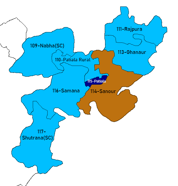
The district is divided into three sub-divisions: Patiala, Rajpura and Nabha, which are further divided into six tehsils: Patiala, Rajpura, Nabha, Samana, Dudhan Sadhan and Pattran. It also comprises ten blocks, Patiala, Rajpura, Nabha and Samana, Patran, Ghanour, Shambhu kalan, Sanour, Patiala Rural, Bhunerheri.
There are nine Punjab Vidhan Sabha constituencies located in this district: Patiala Urban, Patiala Rural, Rajpura, Nabha, Samana, Ghanaur, Shutrana, Sanaur, and Patran. All of these are part of Patiala Lok Sabha constituency.
Industry
Patiala is fast emerging as an important industrial growth center on the industrial map of the state. Besides traditional goods, high quality and sophisticated items are now produced including small cutting tools, power cables, Vanaspati ghee, bicycles, and agriculture implements including harvester combines and threshers, milk products, and pesticides. The industrial units are scattered all over the district mainly at Rajpura, Patiala, Samana, and Nabha. There are large and medium industrial units located at Rajpura producing Vanaspati ghee, power cables, bicycles, and bicycle components and at Dera Bassi producing spun-yarn and alcohol. Among the small scale industry in the district are those producing agriculture implements, rice shellers, cutting tools, electrical goods, and bakeries. There are industrial focal points at Patiala, Rajpura, Nabha, and Dera Bassi and two industrial estates at Rajpura, Patiala.
Demographics
Patiala having a population of 1,895,686 is the 4th most populated district of Punjab after Ludhiana, Amritsar, and Jalandhar as per the 2011 census. According to the 2011 census, Patiala district has a population of 1,895,686, roughly equal to the nation of Slovenia or the US state of Mississippi. This gives it a ranking of 248th in India (out of a total of 640). The district has a population density of 596 PD/sqkm. Its population growth rate over the decade 2001-2011 was 19.4%. Patiala has a sex ratio of 888 females for every 1000 males, and a literacy rate of 76.3%. Scheduled Castes made up 24.55% of the population.
Gender
The table below shows the sex ratio of Patiala district through decades.
| Census Year | Sex Ratio |
|---|---|
| 1951 | 1961 |
| 809 | 831 |
The table below shows the child sex ratio of children below the age of 6 years in the rural and urban areas of Patiala district.
| Year | Urban | Rural |
|---|---|---|
| 2011 | 852 | 827 |
| 2001 | 794 | 769 |
Religion
The table below shows the population of different religions in absolute numbers in the urban and rural areas of Patiala district.
| Religion | Urban (2011) | Rural (2011) | Urban (2001) | Rural (2001) | Urban (1991) | Rural (1991) |
|---|---|---|---|---|---|---|
| Hindu | 4,53,619 | 3,29,687 | 3,86,288 | 3,92,139 | 2,95,473 | 3,68,233 |
| Sikh | 2,88,984 | 7,70,960 | 2,45,618 | 7,78,928 | 1,63,175 | 7,14,590 |
| Muslim | 13,812 | 26,231 | 8,237 | 26,591 | 2,899 | 19,275 |
| Christian | 2,847 | 2,836 | 1,864 | 1,901 | 651 | 1,736 |
| Other religions | 4,018 | 2,692 | 2,703 | 665 | 2,097 | 769 |
Language
At the time of the 2011 census, 89.61% of the population spoke Punjabi, 7.79% Hindi and 1.24% Saraiki as their first language.
Health
The table below shows the data from the district nutrition profile of children below the age of 5 years, in Patiala, as of year 2020.
| Indicators | Number of children ( | Percent (2020) | Percent (2016) |
|---|---|---|---|
| Stunted | 29,979 | 20% | 18% |
| Wasted | 14,650 | 10% | 12% |
| Severely wasted | 2,611 | 2% | 5% |
| Underweight | 24,977 | 17% | 14% |
| Overweight/obesity | 634 | 0.4% | 6% |
| Anemia | 101,704 | 77% | 49% |
| Total children | 147,534 |
The table below shows the district nutrition profile of Patiala of women between the ages of 15 and 49 years, as of year 2020.
| Indicators | Number of women (15-49 years) | Percent (2020) | Percent (2016) |
|---|---|---|---|
| Underweight (BMI | 86,269 | 14% | 10% |
| Overweight/obesity | 264,038 | 43% | 35% |
| Hypertension | 176,353 | 29% | 18% |
| Diabetes | 113,959 | 19% | NA |
| Anemia (non-preg) | 400,579 | 65% | 41% |
| Anemia (preg) | 21,607 | 72% | 37% |
| Total women (preg) | 30,156 | ||
| Total women | 615,329 |
The table below shows the current use of family planning methods by currently married women between the ages of 15 and 49 years, in Patiala district.
| Method | Total (2015–16) | Urban (2015–16) | Rural (2015–16) |
|---|---|---|---|
| Female sterilization | 34.5% | 31.0% | 37.3% |
| Male sterilization | 0.4% | 0.6% | 0.2% |
| IUD/PPIUD | 5.9% | 3.9% | 7.6% |
| Pill | 5.2% | 6.7% | 3.9% |
| Condom | 22.4% | 26.9% | 18.6% |
| Any modern method | 68.5% | 69.1% | 67.9% |
| Any method | 79.1% | 79.4% | 78.9% |
| Total unmet need | 3.7% | 4.3% | 3.1% |
| Unmet need for spacing | 2.1% | 3.1% | 1.2% |
The table below shows the number of road accidents and people affected in Patiala district by year.
| Year | Accidents | Killed | Injured | Vehicles Involved |
|---|---|---|---|---|
| 2022 | 648 | 412 | 437 | 984 |
| 2021 | 643 | 430 | 484 | 727 |
| 2020 | 512 | 339 | 380 | 774 |
| 2019 | 610 | 354 | 467 | 819 |
Topography
Most of the area is plains in the form of agricultural land. The river Ghaghar remains dry during most part of the year. However, during the rainy season, it often causes flooding in the adjoining villages, which results in damage to the crops, livestock, and human lives. Other subsidiary rivers are Tangri Nadi, Patiala-Wali-Nadi, Sirhind Choe, and the Jhambowali Choe.
Apart from the natural water lines, the Bhakra Main Line canal, the Nawana Branch, and the Ghaghar Link are the most important. These canals are the backbone of the irrigation system of the district.
Politics
| No. | Constituency | Name of MLA | Party | Bench | 109 | 110 | 111 | 113 | 114 | 115. | 116 | 117 |
|---|---|---|---|---|---|---|---|---|---|---|---|---|
| Nabha (SC) | Gurdev Singh Dev Maan | Government | ||||||||||
| Patiala Rural | Balbir Singh | Government | ||||||||||
| Rajpura | Neena Mittal | Government | ||||||||||
| Ghanaur | Gurlal Ghanaur | Government | ||||||||||
| Sanour | Harmit Singh Pathanmajra | Government | ||||||||||
| Patiala | Ajit Pal Singh Kohli | Government | ||||||||||
| Samana | Chetan Singh Jaura Majra | Government | ||||||||||
| Shutrana (SC) | Kulwant Singh Bazigar | Government |
Notable people
- Umang Gupta, an Indian-American entrepreneur in Silicon Valley, California
- Sanju Bansal, an Indian-American businessman, co-founder of MicroStrategy, a worldwide provider of enterprise software platforms
- Kamal Khan, a singer
References
References
- "Table C-01 Population by Religious Community: Punjab". [[Registrar General and Census Commissioner of India]].
- Census Report 1941 Patiala State, BY Lt. Col. Sukhdev Singh, Superintendent, Census Operations, page 10, [https://censusindia.gov.in/nada/index.php/catalog/31317 Census of India Digital Library]
- ''Punjab Phulkian States Gazetteers, Volume XVII-A, 1904'', p. 139. [[iarchive:dli.ministry.08612. Available at Archive.org]]
- [https://censusindia.gov.in/nada/index.php/catalog/31763 1951 Census of india, Punjab, Pepsu, Hiamchal, delhi, bilaspur Part- I Report]
- Page No. 10,11 - [https://censusindia.gov.in/nada/index.php/catalog/30478 General Population Tables, Part II-A , Vol-XIII, Punjab - Census 1961]
- About Dera Bassi - https://dera-bassi.punjabonline.in/guide/about-dera-bassi?utm_source=chatgpt.com
- [https://fatehgarhsahib.nic.in/about-district/#:~:text=The%20historic%20and%20pious%20District,of%20Guru%20Gobind%20Singh%20Ji. About Fatehgarth sahib District nic.in]
- [https://sasnagar.nic.in/about-district-second/#:~:text=Sahibzada%20Ajit%20Singh%20Nagar%20District,carved%20out%20from%20District%20Patiala. About Mohali District nic.in]
- [https://patiala.nic.in/administrative-setup/ Adm Setup Patiala District nic.in]
- "District Wise Assembly Constituencies". Chief Electoral Officer, Haryana website.
- "Delimitation of Parliamentary and Assembly Constituencies Order, 2008". The Election Commission of India.
- "2011, Table C-01 Population by Religious Community: Punjab". [[Registrar General and Census Commissioner of India]].
- [http://www.censusindia.gov.in/2011census/PCA/A2_Data_Table.html Decadal Variation In Population Since 1901]
- "District Census Hand Book – Patiala". [[Registrar General and Census Commissioner of India]].
- US Directorate of Intelligence. "Country Comparison:Population".
- "2010 Resident Population Data". U. S. Census Bureau.
- (21 January 2022). "District-wise Decadal Sex ratio in Punjab".
- (21 January 2022). "District-wise Rural and Urban Child Population (0-6 years) and their sex ratio in Punjab".
- "Patiala District Religion Data - Census 2011".
- (21 January 2022). "Open Government Data (OGD) Platform India".
- "Table C-16 Population by Mother Tongue: Punjab". [[Registrar General and Census Commissioner of India]].
- "About District Nutrition Profiles".
- "About District Nutrition Profiles".
- (21 January 2022). "Road Accidents in Punjab".
This article was imported from Wikipedia and is available under the Creative Commons Attribution-ShareAlike 4.0 License. Content has been adapted to SurfDoc format. Original contributors can be found on the article history page.
Ask Mako anything about Patiala district — get instant answers, deeper analysis, and related topics.
Research with MakoFree with your Surf account
Create a free account to save articles, ask Mako questions, and organize your research.
Sign up freeThis content may have been generated or modified by AI. CloudSurf Software LLC is not responsible for the accuracy, completeness, or reliability of AI-generated content. Always verify important information from primary sources.
Report