From Surf Wiki (app.surf) — the open knowledge base
Pathum Thani province
Province of Thailand
Province of Thailand
| Field | Value |
|---|---|
| name | Pathum Thani |
| native_name | ปทุมธานี |
| native_name_lang | th |
| settlement_type | Province |
| image_skyline | {{multiple image |
| border | infobox |
| total_width | 280 |
| image_style | border:1; |
| perrow | 2/2/2 |
| image1 | D85 3734 อนุสรณ์สถานแห่งชาติ The National Memorial of Thailand Photographed by Trisorn Triboon (30).jpg |
| image2 | Pathumthani the National Archives in Commemoration of H.M. the King’s Golden Jubilee 1.jpg |
| image3 | Thammasat University pond.jpg |
| image4 | ตลาดสดเทศบาลเมืองปทุมธานี ถนนปทุมสัมพันธ์.jpg |
| image5 | Tornado -dw 2w.jpg |
| image6 | Dhammakaya cetiya night.jpg |
| image_size | 200px |
| image_caption | From left to right, top to bottom: Thailand National Memorial; A Royal Ploughing Ceremony exhibition in Golden Jubilee Museum of Agriculture; Thammasat University's pond; Street in Pathum Thani town; Tornado frisbee in the Dream World; Wat Phra Dhammakaya |
| nicknames | Pathum (ปทุม) |
| Mueang Pathum (เมืองปทุม) | |
| mottoes | ถิ่นบัวหลวง เมืองรวงข้าว เชื้อชาวมอญ นครธรรมะ พระตำหนักรวมใจ สดใสเจ้าพระยา ก้าวหน้าอุตสาหกรรม |
| ("Home of the royal lotus. Town of rice ears. Mon people. City of Dharma. Palace of unity. Bright Chao Phraya (River). Progressive industry.") | |
| image_flag | Flag of Pathum Thani.svg |
| image_seal | Seal of Pathum Thani.svg |
| image_map | Thailand Pathum Thani locator map.svg |
| mapsize | frameless |
| map_caption | Map of Thailand highlighting Pathum Thani province |
| subdivision_type | Country |
| subdivision_name | Thailand |
| subdivision_type2 | Region |
| subdivision_name2 | Central Thailand |
| subdivision_type3 | Capital |
| subdivision_name3 | Pathum Thani |
| subdivision_type4 | Largest City |
| subdivision_name4 | Rangsit |
| leader_title | Governor |
| leader_name | Somkid Chanthamaruk |
| (since 2024) | |
| leader_title1 | PAO President |
| area_footnotes | |
| area_total_km2 | 1,520 |
| area_rank | 70th |
| population_footnotes | |
| population_total | 1,236,471 |
| population_as_of | 2024 |
| population_rank | 17th |
| population_density_km2 | 813 |
| population_density_rank | 4th |
| demographics_type2 | GDP |
| demographics2_footnotes | |
| demographics2_title1 | Total |
| demographics2_info1 | baht 381 billion |
| (US$13 billion) (2019) | |
| demographics_type1 | Human Achievement Index |
| demographics1_footnotes | |
| demographics1_title1 | HAI (2022) |
| demographics1_info1 | 0.6589 "somewhat high" |
| Ranked 15th | |
| timezone1 | ICT |
| utc_offset1 | +7 |
| postal_code_type | Postal code |
| postal_code | 10xxx |
| area_code_type | Calling code |
| area_code | 02 |
| iso_code | TH-13 |
| website |
Mueang Pathum (เมืองปทุม) ("Home of the royal lotus. Town of rice ears. Mon people. City of Dharma. Palace of unity. Bright Chao Phraya (River). Progressive industry.") (since 2024) (US$13 billion) (2019) Ranked 15th Pathum Thani (, ) is one of the central provinces (changwat) of Thailand. Neighboring provinces are (from north clockwise): Phra Nakhon Si Ayutthaya, Saraburi, Nakhon Nayok, Chachoengsao, Bangkok, and Nonthaburi.
The province is north of Bangkok and is part of the Bangkok metropolitan area. In many places, the boundary between the two provinces is not noticeable as both sides of the boundary are equally urbanized. Pathum Thani town is the administrative seat, but Ban Rangsit, seat of Thanyaburi district, is the largest populated place in the province.
Pathum Thani is an old province, heavily populated by the Mon people, dotted with 186 temples and parks. The Dream World amusement park is here.
Geography
The province lies on the low alluvial flats of the Chao Phraya River that flows through the capital. Many canals (khlongs) cross the province and feed the rice paddies. There is no forest area in the province.
History
The city dates back to a settlement founded by Mon migrating from Mottama () in Myanmar around 1650. The original name was Sam Khok. In 1815, King Rama II visited the city and the citizens offered him many lotus flowers, which prompted the king to rename the city Pathum Thani, meaning 'lotus flower town'.
Symbols
The provincial seal shows a pink lotus flower with two rice stalks bending over it, representing the fertility of the province. The provincial tree is the Indian coral tree (Erythrina variegata). The provincial flower is the lotus (Nymphaea lotus). The provincial aquatic animal is the marble goby (Oxyeleotris marmorata).
Education and technology
Pathum Thani has a very high concentration of higher education institutions, especially ones in the field of science and technology. This, together with a large number of industrial parks and research facilities (including those in Thailand Science Park), make the region the educational and technology hub of the area.
; Academic institutes : National Science Museum, Asian Institute of Technology, Bangkok University (Rangsit Campus), Eastern Asia University, North Bangkok University (Rangsit), Pathumthani University, Rajamangala University of Technology, Rangsit University, Shinawatra University, Sirindhorn International Institute of Technology, Thammasat University (Rangsit Center), and Valaya Alongkorn Rajahbhat University
; Research bodies : Thailand Science Park, National Science and Technology Development Agency (NSTDA), National Center for Genetic Engineering and Biotechnology (BIOTEC), National Metal and Materials Technology Center (MTEC), National Nanotechnology Center (NANOTEC), National Electronics and Computer Technology Center (NECTEC), Thailand Institute of Scientific and Technological Research (TISTR)
; Industrial parks : Software Park Thailand (in Nonthaburi, southwest of Pathum Thani), Nava Nakorn Industrial Promotion Zone (1376 acres / 5.6 km2), Bangkadi Industrial Park (470 acres / 1.9 km2), Techno Thani (a "Technology City" administered by the Ministry of Science and Technology), and a number of industrial parks in neighboring Ayutthaya and Nonthaburi provinces.
Administrative divisions
Provincial government

]]
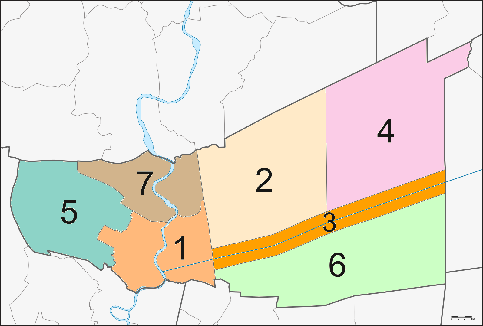
The province is divided into seven districts (amphoes). The districts are further subdivided into 60 communes (tambons) and 529 villages (mubans).
Local government
As of 29 September 2020 there are: one Pathum Thani Provincial Administrative Organization - PAO (ongkan borihan suan changwat) and twenty-nine municipal (thesaban) areas in the province. Rangsit has city (thesaban nakhon) status. Further ten have town (thesaban mueang) status and eighteen subdistrict municipalities (thesaban tambon).
| City municipality | 1 | Rangsit | 85,260 |
|---|
| 5 | Khu Khot | 44,274 | 10 | Bang Kadi | 13,987 |
|---|
| 9 | Nong Sam Wang | 11,016 | 18 | Nong Suea | 2,901 |
|---|
The non-municipal areas are administered by 35 Subdistrict Administrative
Organizations - SAO (ongkan borihan suan tambon).
| Bang Kadi | 18 |
|---|
Human achievement index 2022
| Province Pathum Thani, with an HAI 2022 value of 0.6589 is "somewhat high", occupies place 15 in the ranking. |
|---|
Since 2003, United Nations Development Programme (UNDP) in Thailand has tracked progress on human development at sub-national level using the Human achievement index (HAI), a composite index covering all the eight key areas of human development. National Economic and Social Development Board (NESDB) has taken over this task since 2017.
| 62 - 77 | "low" |
|---|
| [[File:HAI 2022 rankings.svg | 950px]] |
|---|
References
References
- "Table 2 Forest area Separate province year 2019". Royal Forest Department.
- "Official statistics registration systems". Department of Provincial Administration (DOPA).
- (July 2019). "''Gross Regional and Provincial Product, 2019 Edition''". Office of the National Economic and Social Development Council (NESDC).
- "ข้อมูลสถิติดัชนีความก้าวหน้าของคน ปี 2565 (PDF)".
- "Population Statistics 2008". Department of Provincial Administration.
- "Dream World". Dreamworld.co.th.
- (2019). "ตารางที่ 2 พี้นที่ป่าไม้ แยกรายจังหวัด พ.ศ.2562".
- Rajanubhab, D., 2001, ''Our Wars With the Burmese'', Bangkok: White Lotus Co. Ltd., {{ISBN. 9747534584
- "Pathum Thani". Tourism Authority of Thailand.
- (2024-12-04). "มาดูกัน..ดอกไม้ประจำจังหวัดต่าง ๆ ของประเทศไทย". Kapook.com.
- (December 2019). "สถิติทางการทะเบียน". Department of Provincial Administration (DOPA).
- (1 June 2011). "ประกาศกระทรวงมหาดไทย เรื่อง เปลี่ยนแปลงฐานะเทศบาลเมืองรังสิต อำเภอธัญบุรี จังหวัดปทุมธานี เป็นเ ทศบาลนครรังสิต พ.ศ.๒๕๕๔". Royal Thai Government Gazette.
- (9 October 2001). "พระราชฤษฎีกา จัดตั้งเทศบาลเมืองท่าโขลง พ.ศ.๒๕๔๔". Royal Thai Government Gazette.
- (11 January 2012). "ประกาศกระทรวงมหาดไทย เรื่อง เปลี่ยนแปลงฐานะเทศบาลตำบลบึงยี่โถ อำเภดธัญบุรี จังหวัดปทุมธาบี เป็นเทศบาลเมืองบึงยี่โถ พ.ศ.๒๕๕๕". Royal Thai Government Gazette.
- (2020). "ประวัติความเป็นมา".
- (19 July 2004). "ประกาศกระทรวงมหาดไทย เรื่อง เปลี่ยนแปลงฐานะเทศบาลตำบลสนั่นรักษ์ อำเภดธัญบุรี จังหวัดปทุมธาบี เป็นเทศบาลเมืองสนั่นรักษ์ พ.ศ.๒๕๔๗". Royal Thai Government Gazette.
- (23 September 2011). "Number of local government organizations: Summary elevating local authorities.". Department of Local Administration (DLA).
- (14 September 2005). "ประกาศกระทรวงมหาดไทย เรื่อง เปลี่ยนแปลงฐานะเทศบาลตำบลคลองหลวง อำเภดคลองหลวง จังหวัดปทุมธาบี เป็นเทศบาลเมืองคลองหลวง พ.ศ.๒๕๔๘". Royal Thai Government Gazette.
- (29 November 1936). "พระราชกฤษฎีกา จัดตั้งเทศบาลเมืองปทุมธานี จังหวัดปทุมธานี พุทธศักราช ๒๔๗๙". Royal Thai Government Gazette.
- (6 March 1996). "พระราชกฤษฎีกาจัดตั้งเทศบลเมืองคูคต พ.ศ.๒๕๓๙". Royal Thai Government Gazette.
- (8 September 2020). "ประกาศกระทรวงมหาดไทย เรื่อง เปลี่ยนแปลงฐานะเทศบาลตำบลบางกะดี อำเภดเมืองปทุมธานี จังหวัดปทุมธาบี เป็นเทศบาลเมืองบางกะดี". Royal Thai Government Gazette.
- (24 February 1999). "พระราชกฤษฎีกา เปลี่ยนแปลงฐานะของสุขาภิบาลเป็นเทศบาล พ.ศ.๒๕๔๒". Royal Thai Government Gazette.
- (2 September 2011). "Number of local government organizations: Summary elevating local authorities.". Department of Local Administration (DLA).
- (2020). "ประวัติหน่วยงาน".
- (4 August 2011). "Number of local government organizations: Summary elevating local authorities.". Department of Local Administration (DLA).
- (2 September 2011). "Number of local government organizations: Summary elevating local authorities.". Department of Local Administration (DLA).
- (30 September 2011). "Number of local government organizations: Summary elevating local authorities.". Department of Local Administration (DLA).
- (4 August 2011). "Number of local government organizations: Summary elevating local authorities.". Department of Local Administration (DLA).
- (2 September 2011). "Number of local government organizations: Summary elevating local authorities.". Department of Local Administration (DLA).
- (2 September 2011). "Number of local government organizations: Summary elevating local authorities.". Department of Local Administration (DLA).
- Department of Provincial Administration (DOPA), List of 5,324 SAO's information as of date 20 December 2019, 35 SAO's (no.2116-2151) were established in 1994 (1), in 1995 (19), in 1996 (10) and in 1997 (5).
- (2020). "ด้านชุมชน".
- (2020). "กลุ่มอค์กร".
- (2020). "ชุมชน".
- (2020). "ข้อมูลชุมชน".
- (2020). "1. สภาพทั่วไป (5.3)".
- (2020). "ข้อมูลเทศบาล".
- (2020). "ชุมชน".
This article was imported from Wikipedia and is available under the Creative Commons Attribution-ShareAlike 4.0 License. Content has been adapted to SurfDoc format. Original contributors can be found on the article history page.
Ask Mako anything about Pathum Thani province — get instant answers, deeper analysis, and related topics.
Research with MakoFree with your Surf account
Create a free account to save articles, ask Mako questions, and organize your research.
Sign up freeThis content may have been generated or modified by AI. CloudSurf Software LLC is not responsible for the accuracy, completeness, or reliability of AI-generated content. Always verify important information from primary sources.
Report