From Surf Wiki (app.surf) — the open knowledge base
Parkways in New York
Highway system
Highway system
| Field | Value | ||||
|---|---|---|---|---|---|
| shields | [[File:Bronx River Pkwy Shield.svg | x65px]][[File:Grand Central Pkwy Shield free.svg | x65px]][[File:Wantagh Pkwy Shield.svg | x65px]][[File:Palisades Interstate Pkwy.svg | x65px]] |
| caption | Standard parkway markers in New York | ||||
| interstate | Interstate X (I-X) | ||||
| us | U.S. Route X (US X) | ||||
| statehwy | New York State Route X (NY X) | ||||
| links | NY |
Most parkways in the US state of New York are part of a statewide parkway system owned by several public and private agencies but mostly maintained by the New York State Department of Transportation (NYSDOT). A handful of other roads in the Hudson Valley and on Long Island are also known as parkways but are not part of the state system. The roads of the state parkway system were among the first expressways to be constructed. These highways were not divided and allowed no driveway cuts, but did have intersections for some of the streets they crossed. A small section of the privately financed Long Island Motor Parkway was the first expressway to begin operation as a toll road and the first highway to use bridges and overpasses to eliminate intersections.
The individual parkways vary widely in composition. Some, such as the Sprain Brook Parkway, are functionally equivalent to a freeway; others, like Seven Lakes Drive, are two-lane undivided roads. Most parkways are located in downstate New York, where the state parkway system originated in the early 20th century.
State parkways
The state's parkway system originally began as a series of then-high-speed (25 mph) four-lane roads that were created to provide a scenic way into, out of, and around New York City. The first section of this system opened in 1908. Most of the early roads have been replaced and redesigned to address higher speed requirements and to increase capacity. In later sections north of New York City, the roadways were typically divided by a wide landscaped median and provided service areas along the way that offered fuel and restrooms. During the 1930s, urban planner Robert Moses developed a system of parkways in the New York City area.
Many of these parkways were built by regional agencies such as the Long Island State Park Commission (LISPC), New York City Parks Department, Taconic State Park Commission (TSPC), Westchester County Parks Commission (WCPC), and Palisades Interstate Park Commission (PIPC). Most are now maintained, if not owned, by NYSDOT outside New York City and the New York City Department of Transportation (NYCDOT) within New York City.
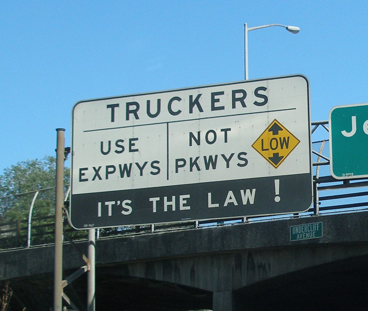
Today, the state parkways are for the most part equivalent to expressways and freeways built in other parts of the country, except for a few oddities. First, because many of these roads were either designed before civil engineers had experience building roads for automobile use or widened in response to increasing traffic, many New York parkways lack shoulders. Second, because designers focused more on making routes scenic rather than efficient, the parkways are meandering, often built to follow a river, and so contain many turns. Finally, because most use low, decorative stone-arch overpasses that would trap trucks, commercial vehicles, trucks and tractor trailers are banned from parkways. In Manhattan, this has led to nearly all trucks being forced onto local streets as the island has only one short Interstate (the Trans-Manhattan Expressway) passing through Washington Heights, a neighborhood in Upper Manhattan.
List of parkways
| Parkway | Opened | Region | From | To | Owner | Maintained by | |||||||||
|---|---|---|---|---|---|---|---|---|---|---|---|---|---|---|---|
| Bay Parkway | 1892 as 22nd Avenue | New York City | Brooklyn | Brooklyn | NYSDOT/NYCDOT | ||||||||||
| Bay Parkway | N/A | Long Island | Jones Beach State Park | Jones Beach State Park | NYS OPRHP | ||||||||||
| [[File:Bear Mountain Pkwy Shield.svg | 30px | link= | alt=]] | Bear Mountain State Parkway | 1932 | Hudson Valley | Peekskill | Cortlandt | NYSDOT | ||||||
| [[File:Belt Pkwy Shield free.svg | 25px | link= | alt=]] | Belt Parkway | 1941 | New York City | Brooklyn | Queens | NYSDOT/NYCDOT | ||||||
| [[File:Bethpage Pkwy Shield.svg | 25px | link= | alt=]] | Bethpage State Parkway | title=New Highway Across Long Island To Link North and South Shores | newspaper=The New York Times | date=November 15, 1936 | page=N1}} | Long Island | Massapequa | Bethpage State Park | NYS OPRHP | |||
| [[File:Bronx River Pkwy Shield free.svg | 25px | link= | alt=]] | Bronx River Parkway | 1908 | Hudson Valley | The Bronx | North Castle | NYCDOT/Westchester County | ||||||
| [[File:Cross County Pkwy Shield.svg | 30px | link= | alt=]] | Cross County Parkway | 1947 | Hudson Valley | Yonkers | Eastchester | NYSDOT | ||||||
| [[File:Cross Island Pkwy Shield free.svg | 25px | link= | alt=]] | Cross Island Parkway | 1940 | New York City | Queens | Queens | NYCDOT | ||||||
| Eastern Parkway | 1874 | New York City | Brooklyn | Brooklyn | NYCDOT | ||||||||||
| [[File:FDR Drive Shield free.svg | 25px | link= | alt=]] | Franklin D. Roosevelt East River Drive | 1955 | New York City | Lower Manhattan | Upper Manhattan | NYSDOT/NYCDOT | ||||||
| [[File:Grand Central Pkwy Shield free.svg | 25px | link= | alt=]] | Grand Central Parkway | 1936 | New York City | Queens | New York City line | NYSDOT | ||||||
| [[File:Harlem River Drive Shield free.svg | 25px | link= | alt=]] | Harlem River Drive | 1964 | New York City | Upper Manhattan | Upper Manhattan | NYSDOT | ||||||
| [[File:Heckscher Pkwy Shield.svg | 25px | link= | alt=]] | Heckscher State Parkway | 1959 | Long Island | West Islip | Heckscher State Park | NYS OPRHP | ||||||
| [[File:Henry Hudson Pkwy Shield free.svg | 25px | link= | alt=]] | Henry Hudson Parkway | 1937 | New York City | Manhattan | New York City line | NYSDOT/NYCDOT/PANYNJ | ||||||
| [[File:Hutchinson River Pkwy Shield free.svg | 25px | link= | alt=]] | Hutchinson River Parkway | 1928 | Hudson Valley | The Bronx | Connecticut state line | NYSDOT/NYCDOT | ||||||
| [[File:Jackie Robinson Pkwy Shield free.svg | 25px | link= | alt=]] | Jackie Robinson Parkway | 1935 | New York City | Brooklyn | Queens | NYCDOT | ||||||
| [[File:Korean War Veterans Pkwy Shield.svg | 30px | link= | alt=]] | Korean War Veterans Parkway | 1972 | New York City | Staten Island | Staten Island | NYSDOT | ||||||
| [[File:Lake Ontario State Pkwy Shield.svg | 25px | alt= | link=]] | Lake Ontario State Parkway | Western New York | Carlton | Rochester | NYSDOT/NYS OPRHP | |||||||
| Little Neck Parkway | New York City | Queens | Queens | ||||||||||||
| [[File:Lake Welch Pkwy Shield.svg | 25px | link= | alt=]] | Lake Welch Parkway | url=https://news.google.com/newspapers?id=8oFGAAAAIBAJ&dq=lake%20welch%20parkway&pg=5747%2C5078611 | title=Parkway Now Open | work=The Evening News | location=Newburgh, NY | page=1B | date=June 28, 1971 | access-date=June 12, 2013}} | Hudson Valley | Harriman State Park | Harriman State Park | PIPC |
| Long Mountain Parkway | Hudson Valley | Harriman State Park | Bear Mountain State Park | NYSDOT | |||||||||||
| [[File:Loop Pkwy Shield.svg | 25px | link= | alt=]] | Loop Parkway | title=New Local Roads Soon; Meadowbrook Open for Traffic to Beaches | newspaper=The New York Times | date=June 2, 1935 | page=XX12}} | Long Island | Lido Beach | Jones Beach State Park | NYS OPRHP | |||
| [[File:Meadowbrook Pkwy Shield.svg | 25px | link= | alt=]] | Meadowbrook State Parkway | 1934 | Long Island | Jones Beach State Park | Westbury | NYS OPRHP | ||||||
| [[File:Mosholu Pkwy Shield.svg | 30px | link= | alt=]] | Mosholu Parkway | 1937 | New York City | Bronx Park | Van Cortlandt Park | NYSDOT/NYCDOT | ||||||
| [[File:Niagara Scenic Pkwy Shield.svg | 20px | link= | alt=]] | Niagara Scenic Parkway | Western New York | Niagara Falls | Porter | NYS OPRHP | |||||||
| [[File:Northern Pkwy Shield.svg | 25px | link= | alt=]] | Northern State Parkway | 1931 | Long Island | New York City line | Hauppauge | NYS OPRHP | ||||||
| Ocean Parkway | New York City | Brooklyn | Brooklyn | ||||||||||||
| [[File:Ocean Pkwy Shield.svg | 25px | link= | alt=]] | Ocean Parkway | Long Island | Jones Beach State Park | Captree State Park | NYS OPRHP | |||||||
| [[File:Palisades Interstate Pkwy.svg | 25px | link= | alt=]] | Palisades Interstate Parkway | title=Palisades Route Will Open Today | newspaper=The New York Times | date=August 28, 1958}} | Hudson Valley | Fort Lee, NJ | Bear Mountain State Park | PIPC | ||||
| [[File:Pelham Pkwy Shield.svg | 30px | link= | alt=]] | Pelham Parkway | 1911 | New York City | The Bronx | Pelham Bay Park | NYCDOT | ||||||
| Prospect Mountain Veterans Memorial Highway | url=http://poststar.com/news/local/article_65520905-7c52-5af2-9159-a6bcaaffa56c.html | title=Missing veterans honored on mountaintop | newspaper=The Post-Star | location=Glens Falls, NY | first=Pamela A. | last=Brooks | date=June 4, 2007 | access-date=March 18, 2010}} | Adirondacks | Lake George | Prospect Mountain | NYSDEC | |||
| [[File:Robert Moses Cswy Shield.svg | 25px | link= | alt=]] | Robert Moses Causeway | Long Island | Robert Moses State Park | West Islip | NYS OPRHP | |||||||
| Rockaway Parkway | New York City | Brooklyn | Brooklyn | ||||||||||||
| [[File:Sagtikos Pkwy Shield.svg | 25px | link= | alt=]] | Sagtikos State Parkway | title=Two Main Long Island Parkways to Be Linked at East Ends Today | url=https://www.nytimes.com/1952/09/29/archives/two-main-long-island-parkways-to-be-linked-at-east-ends-today.html | newspaper=The New York Times | date=September 29, 1952 | page=25 | access-date=June 12, 2013}} | Long Island | West Islip | Commack | NYS OPRHP | |
| [[File:Saw Mill Pkwy Shield.svg | 30px | link= | alt=]] | Saw Mill River Parkway | 1954 | Hudson Valley | New York City line | Bedford | NYS OPRHP | ||||||
| [[File:Seven Lakes Drive Shield.svg | 25px | link= | alt=]] | Seven Lakes Drive | Hudson Valley | Sloatsburg | Bear Mountain State Park | PIPC | |||||||
| [[File:Southern Pkwy Shield.svg | 25px | link= | alt=]] | Southern State Parkway | 1949 | Long Island | Valley Stream | West Islip | NYS OPRHP | ||||||
| [[File:Sprain Brook Pkwy Shield.svg | 30px | link= | alt=]] | Sprain Brook Parkway | title=Parkway Section at Yonkers Opens | newspaper=The New York Times | date=December 24, 1963 | page=19}} | Hudson Valley | Yonkers | Hawthorne | NYSDOT | |||
| [[File:Sunken Meadow Pkwy Shield.svg | 25px | link= | alt=]] | Sunken Meadow State Parkway | title=L.I. Parkway Link Will Open Today; New Spur Connects Shore and Northern State Parkway | newspaper=The New York Times | date=April 1, 1957 | page=27}} | Long Island | Commack | Sunken Meadow State Park | NYS OPRHP | |||
| [[File:Taconic State Pkwy Shield.svg | 30px | link= | alt=]] | Taconic State Parkway | 1925 | Hudson Valley | North Castle | East Chatham | NYSDOT | ||||||
| [[File:Wantagh Pkwy Shield.svg | 25px | link= | alt=]] | Wantagh State Parkway | 1929 | Long Island | Jones Beach State Park | Westbury | NYS OPRHP | ||||||
| Whiteface Mountain Veterans Memorial Highway | title=Road Up Whiteface Opened To Traffic | newspaper=The New York Times | date=July 21, 1935 | page=3}} | Adirondacks | Wilmington | Whiteface Mountain | NYSDEC |
Other parkways
Some regions of New York have parkways that are not owned or maintained by a state agency. Westchester County, for example, contains some highways that were originally part of the TSPC and WCPC, while Suffolk County has preserved a section of the former Long Island Motor Parkway (LIMP) for current driving and built their own roads on land originally reserved for the LISPC. The surviving remnant of the LIMP in western Suffolk County, named the Vanderbilt Motor Parkway, became a surface road that is no longer an expressway nor off limits to commercial vehicles.
List of parkways
| Parkway | Opened | Region | From | To | Owner | Maintained by | ||||||
|---|---|---|---|---|---|---|---|---|---|---|---|---|
| [[File:Arden Valley Road.svg | 20px | link= | alt=]] Arden Valley Road | 1922 | Hudson Valley | Harriman State Park | Harriman State Park | PIPC | PIPC | |||
| Central Westchester Parkway | Hudson Valley | White Plains | White Plains | Westchester County | Westchester County | |||||||
| Farragut Parkway | Hudson Valley | Hastings-on-Hudson | Hastings-on-Hudson | Westchester County | Westchester County | |||||||
| [[File:Suffolk County Route 75 NY.svg | 20px | link= | alt=]] Fire Island Beach Road | Long Island | Fire Island | Fire Island | Suffolk County | Suffolk County | ||||
| Memorial Parkway | Mohawk Valley | Genesee Street, Utica | Albany Street, Utica | City of Utica | City of Utica | |||||||
| Playland Parkway | last=Panetta | first=Roger | title=Westchester: The American Suburb | year=2006 | publisher=Fordham University Press | isbn=9780823225941 | pages=53}} | Hudson Valley | Harrison | Playland | Westchester County | Westchester County |
| [[File:Tiorati Brook Road.svg | 20px | link= | alt=]] Tiorati Brook Road | Hudson Valley | Harriman State Park | Bear Mountain State Park | PIPC | PIPC | ||||
| [[File:Suffolk County Route 67 NY.svg | 20px | link= | alt=]] Vanderbilt Motor Parkway | Long Island | Melville | Lake Ronkonkoma | Suffolk County | Suffolk County | ||||
| [[File:Suffolk County Route 46 NY.svg | 20px | link= | alt=]] William Floyd Parkway | Long Island | Fire Island | Rocky Point | Suffolk County | Suffolk County |
References
References
- [https://web.archive.org/web/20060208041755/http://www.nycroads.com/roads/bronx-river/ nycroads.com Bronx River Parkway]
- [http://sbiii.com/limppix/limpgate.gif Sam Berlinner's Long Island Motor Parkway page; Map of Toll Booths on Long Island Motor Parkway]
- [http://www.nycroads.com/history/motor/ nycroads.com Long Island Motor Parkway]
- [http://www.nycroads.com/history/parkway/ nycroads.com Long Island Parkway System History]
- (2008). "The World Beyond the Windshield: Roads and Landscapes in the United States and Europe". Ohio University Press.
- [https://www.dot.ny.gov/divisions/operating/osss/repository/NYCDOT%20NYSDOT%20Parkways%20Brochure%20October%202009.pdf New York State Department of Transportation - Got Stuck? ]
- (November 15, 1936). "New Highway Across Long Island To Link North and South Shores". The New York Times.
- (November 1, 1962). "L.I. Parkway to Open". The New York Times.
- (June 28, 1971). "Parkway Now Open". The Evening News.
- (June 2, 1935). "New Local Roads Soon; Meadowbrook Open for Traffic to Beaches". The New York Times.
- (August 28, 1958). "Palisades Route Will Open Today". [[The New York Times]].
- "History of the Pelham Parkway".
- Brooks, Pamela A.. (June 4, 2007). "Missing veterans honored on mountaintop". [[The Post-Star]].
- (September 29, 1952). "Two Main Long Island Parkways to Be Linked at East Ends Today". [[The New York Times]].
- (December 24, 1963). "Parkway Section at Yonkers Opens". The New York Times.
- (April 1, 1957). "L.I. Parkway Link Will Open Today; New Spur Connects Shore and Northern State Parkway". The New York Times.
- (July 21, 1935). "Road Up Whiteface Opened To Traffic". The New York Times.
- Panetta, Roger. (2006). "Westchester: The American Suburb". [[Fordham University]] Press.
- New York State Department of Transportation. (January 2012). "Official Description of Highway Touring Routes, Bicycling Touring Routes, Scenic Byways, & Commemorative/Memorial Designations in New York State".
This article was imported from Wikipedia and is available under the Creative Commons Attribution-ShareAlike 4.0 License. Content has been adapted to SurfDoc format. Original contributors can be found on the article history page.
Ask Mako anything about Parkways in New York — get instant answers, deeper analysis, and related topics.
Research with MakoFree with your Surf account
Create a free account to save articles, ask Mako questions, and organize your research.
Sign up freeThis content may have been generated or modified by AI. CloudSurf Software LLC is not responsible for the accuracy, completeness, or reliability of AI-generated content. Always verify important information from primary sources.
Report