From Surf Wiki (app.surf) — the open knowledge base
Padre Burgos Avenue
Street in Manila, Philippines
Street in Manila, Philippines
| Field | Value | ||||
|---|---|---|---|---|---|
| country | PHL | ||||
| marker_image | [[File:N150 (Philippines).svg | 75px]] [[File:N170 (Philippines).svg | 75px]] | ||
| name | Padre Burgos Avenue | ||||
| alternate_name | Padre Burgos Street | ||||
| namesake | Jose Burgos | ||||
| Sebastián Vidal y Soler (formerly) | |||||
| former_names | Paseo/Calzada de las Aguadas | ||||
| Paseo/Calzada de Sebastián Vidal | |||||
| Paseo/Calzada de Bagumbayan | |||||
| maint | Department of Public Works and Highways - South Manila District Engineering Office | ||||
| length_km | 1.7 | ||||
| length_notes | Approximate length | ||||
| length_ref | |||||
| image | National Museum, Manila City Hall clock tower (Padre Burgos Avenue, Manila; 06-24-2023).jpg | ||||
| caption | Padre Burgos Avenue with the National Museum of Fine Arts (foreground) and the Manila City Hall (background) | ||||
| part_of | {{plainlist | ||||
| * {{jct | country | PHL | N | 150}} from Roxas Boulevard & Bonifacio Drive to MacArthur Bridge | |
| * {{jct | country | PHL | N | 170}} from Quezon Bridge to Liwasang Bonifacio (southbound only) | |
| junction | |||||
| * {{jct | country | PHL | N | 170 | name1=Taft Avenue}} |
| * {{jct | country | PHL | N | 180 | name1=Finance Road}} |
| direction_a | North | ||||
| direction_b | South | ||||
| terminus_a | Near Liwasang Bonifacio in Ermita | ||||
| terminus_b | in Ermita and Intramuros | ||||
| location | Manila |
Sebastián Vidal y Soler (formerly) Paseo/Calzada de Sebastián Vidal Paseo/Calzada de Bagumbayan
- C-1 from Finance Road to Roxas Boulevard & Bonifacio Drive
- from Roxas Boulevard & Bonifacio Drive to MacArthur Bridge
- from Quezon Bridge to Liwasang Bonifacio (southbound only)
{ "type": "FeatureCollection", "features": [ { "type": "Feature", "properties": {}, "geometry": { "type": "LineString", "coordinates": [ [ 120.97549617290498, 14.582938659447924 ], [ 120.97549617290498, 14.582938659447924 ], [ 120.97942292690279, 14.585212568046678 ], [ 120.97942292690279, 14.585212568046678 ], [ 120.97987353801729, 14.585524060546687 ], [ 120.97987353801729, 14.585524060546687 ], [ 120.98013103008272, 14.585773254229407 ], [ 120.98013103008272, 14.585773254229407 ], [ 120.98032414913179, 14.586115895082667 ], [ 120.98032414913179, 14.586115895082667 ], [ 120.98051726818086, 14.586676578965116 ], [ 120.98051726818086, 14.586676578965116 ], [ 120.98096787929536, 14.588358622045357 ], [ 120.98096787929536, 14.588358622045357 ], [ 120.98100006580354, 14.589033512261157 ], [ 120.98100006580354, 14.589033512261157 ], [ 120.98086059093477, 14.589739549041605 ], [ 120.98086059093477, 14.589739549041605 ], [ 120.98025977611543, 14.59184726301762 ], [ 120.98025977611543, 14.59184726301762 ], [ 120.97979843616487, 14.59245984605262 ], [ 120.97979843616487, 14.59245984605262 ], [ 120.97884356975557, 14.593487735788852 ], [ 120.97884356975557, 14.593487735788852 ], [ 120.97839295864107, 14.594089931585835 ], [ 120.97839295864107, 14.594089931585835 ], [ 120.9776955842972, 14.595221639918051 ], [ 120.9776955842972, 14.595221639918051 ] ] } } ] }
Padre Burgos Avenue, also known as Padre Burgos Street, is a 14-lane thoroughfare in Manila, Philippines.
The road was named after Jose Burgos, one of the martyred Gomburza priests who were executed at the nearby Bagumbayan Field (present-day Rizal Park) in 1872. It is a road in the city center, providing access to important thoroughfares like Taft Avenue, Rizal Avenue, Roxas Boulevard, and Quezon Boulevard. The avenue is a component of Circumferential Road 1 (C-1) of Metro Manila's arterial road network and National Route 150 (N150) and National Route 170 (N170) of the Philippine highway network. The Manila City Hall can be accessed using this road, as can the Rizal Park and Intramuros.
Route description
Padre Burgos Avenue starts at the end of Jones Bridge, MacArthur Bridge, and Quezon Bridge, respectively, at the southern bank of the Pasig River near Liwasang Bonifacio. It then merges near Mehan Garden and continues south until it branches to two – Taft Avenue and itself – when it reaches the National Museum of Fine Arts at Rizal Park. It will then turn sharply right, intersecting with Finance Drive, the major thoroughfare of Rizal Park, which leads to Ayala Boulevard and Ayala Bridge, and, after that, the other parts of C-1. Padre Burgos Avenue ends with a junction with Roxas Boulevard, Bonifacio Drive, and Katigbak Drive, its logical continuation towards Quirino Grandstand.
The avenue is a component of National Route 150 (N150), except for its southbound segment between Quezon Bridge and Liwasang Bonifacio Overpass, which is a component of National Route 170 (N170). Its segment from its southern end at Roxas Boulevard and Bonifacio Drive, both components of Radial Road 1, to Finance Drive, is a component of Circumferential Road 1 (C-1).
History
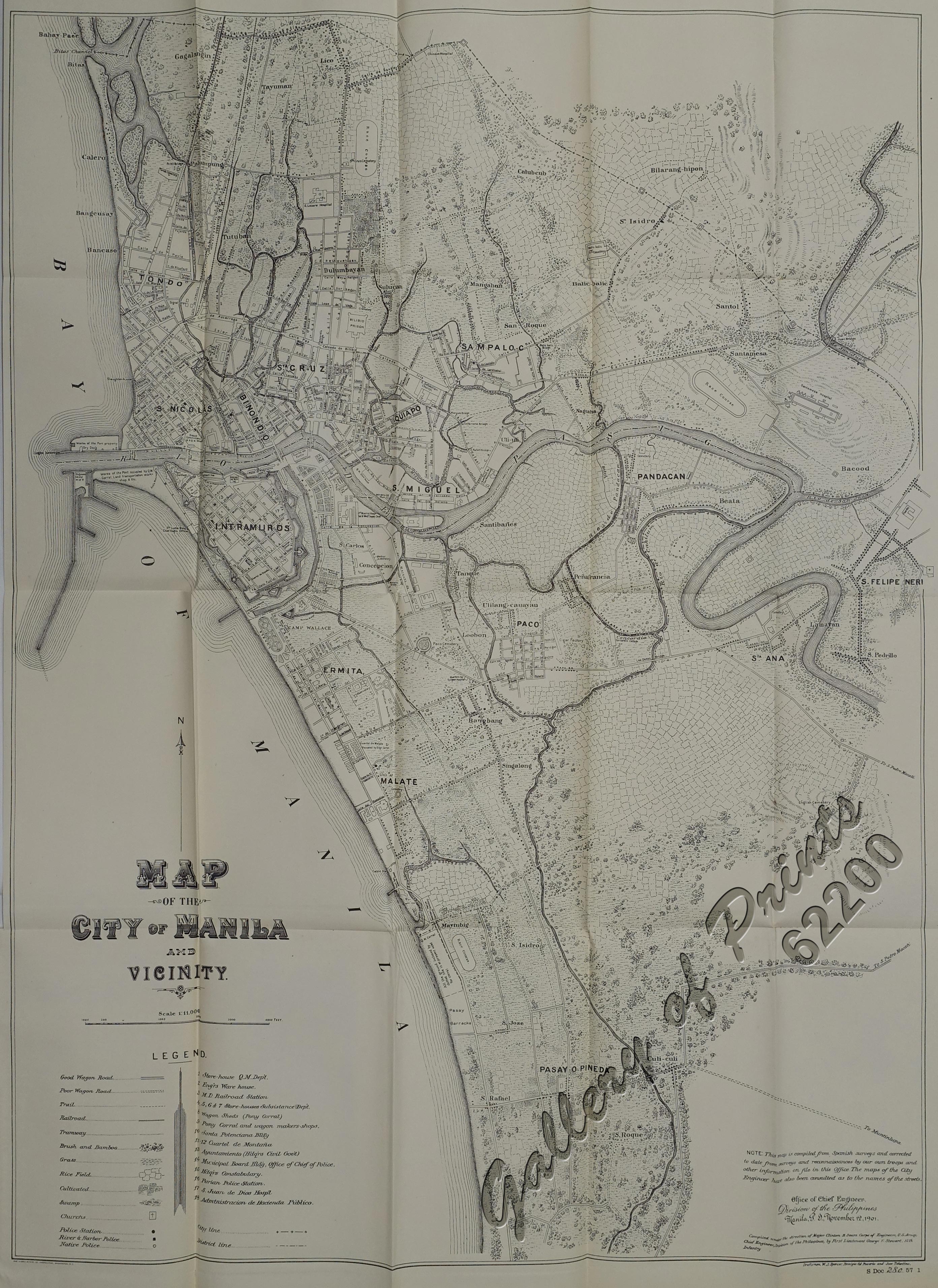
The origin of Padre Burgos Avenue could be traced back to a street running in parallel along the moat surrounding the walled area of Intramuros, called Paseo de las Aguadas or Calzada de las Aguadas, Calzada de Vidal or Paseo de Sebastián Vidal (apparently named after Spanish botanist Sebastián Vidal y Soler, director of the nearby Botanical Garden of Manila), and Calzada de Bagumbayan or Paseo de Bagumbayan (for being the street that leads to Bagumbayan Field). It used to end at Plaza Lawton on the north. It was also one of the right-of-way alignments of tranvía that existed until 1945. The avenue's present-day section near Quezon Bridge occupies what was known as Calle Colgante, which provided access to the bridge's predecessor, Puente Colgante.
Landmarks
Starting from the northern terminus, the road passes the following:
- Manila Central Post Office
- Metropolitan Theater
- Liwasang Bonifacio
- Mehan Garden
- Universidad de Manila
- Bonifacio Shrine
- Manila City Hall
- Lagusnilad
- National Museum of Fine Arts
- National Museum of Anthropology
- Rizal Park
- Roundtable
- National Planetarium
- Club Intramuros Golf Course
- Manila Hotel
References
References
- "Road and Bridge Inventory".
- "Padre Burgos Avenue southbound".
- de Gamoneda, Francisco J.. (1898). "Plano de Manila y sus Arrables".
- (1907). "Map of the City of Manila and vicinity". United States. War Department. General Staff.
- "Paseo de Sebastián Vidal (previously known as Paseo de las Aguadas). This was later renamed Calzada de Bagumbayan and is today known as Padre Burgos Ave. (source: Paquito dela Cruz)".
- (November 12, 1901). "Map of the City of Manila and Vicinity". Office of Chief Engineers, Division of the Philippines.
- (1920). "City of Manila, Philippine Island". John Bach.
- (June 1915). "Map of city of Manila and vicinity". Office of Dept. Engineer, Phil. Dept..
This article was imported from Wikipedia and is available under the Creative Commons Attribution-ShareAlike 4.0 License. Content has been adapted to SurfDoc format. Original contributors can be found on the article history page.
Ask Mako anything about Padre Burgos Avenue — get instant answers, deeper analysis, and related topics.
Research with MakoFree with your Surf account
Create a free account to save articles, ask Mako questions, and organize your research.
Sign up freeThis content may have been generated or modified by AI. CloudSurf Software LLC is not responsible for the accuracy, completeness, or reliability of AI-generated content. Always verify important information from primary sources.
Report