From Surf Wiki (app.surf) — the open knowledge base
Oxford, New Zealand
Town in Canterbury, New Zealand

Town in Canterbury, New Zealand
| Field | Value | |
|---|---|---|
| <!-- See Template:Infobox settlement for additional fields and descriptions --> | name | Oxford |
| native_name | mi | |
| settlement_type | Minor urban area | |
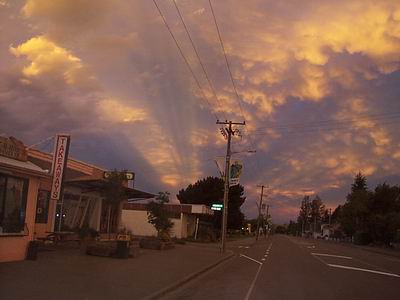
| image_skyline | Oxford NZ Main Street 003.JPG | |
| image_caption | The main street (Inland Scenic Route) of Oxford | |
| mapframe | yes | |
| mapframe-zoom | 8 | |
| coordinates | ||
| subdivision_type | Country | |
| subdivision_name | New Zealand | |
| subdivision_type1 | Region | |
| subdivision_name1 | Canterbury | |
| subdivision_type2 | Territorial authority | |
| subdivision_name2 | Waimakariri District | |
| subdivision_type3 | Ward | |
| subdivision_name3 | Oxford-Ohoka Ward | |
| subdivision_type4 | Community | |
| subdivision_name4 | Oxford-Ohoka Community | |
| seat_type | Electorates | |
| seat | ||
| leader_title | Territorial Authority | |
| leader_name | Waimakariri District Council | |
| leader_title1 | Regional council | |
| leader_name1 | Environment Canterbury | |
| leader_title2 | Mayor of Waimakariri | |
| leader_name2 | ||
| leader_title3 | Waimakariri MP | |
| leader_name3 | ||
| leader_title4 | Te Tai Tonga MP | |
| leader_name4 | ||
| unit_pref | Metric | |
| <!-- for references: use <ref> tags --> | area_footnotes | |
| area_magnitude | ||
| area_total_km2 | 11.82 | |
| elevation_m | 235 | |
| population_total | ||
| population_as_of | ||
| population_footnotes | ||
| population_density_km2 | auto | |
| timezone1 | NZST | |
| utc_offset1 | +12 | |
| timezone1_DST | NZDT | |
| utc_offset1_DST | +13 | |
| postal_code_type | Postcode(s) | |
| postal_code | 7430 | |
| area_code | 03 | |
| website | ||
| area_urban_footnotes | ||
| area_rural_footnotes | ||
| area_metro_footnotes |
| mapframe-zoom = 8 tags --| area_footnotes = Oxford () is a small town serving the farming community of North Canterbury, New Zealand. It is part of the Waimakariri District and is a linear town, approximately 2 km long. Oxford has won awards for the most beautiful village and the most beautiful toilet.
Toponymy
It is unclear whether the town is named after Oxford in England or after its university, but it is more probable that it was named after Samuel Wilberforce, who was the Bishop of Oxford from 1845 to 1870. It was named by the chief surveyor of the Canterbury Association, Joseph Thomas, in 1849.
The town of Tīrau in the North Island was originally also named Oxford, in a name pairing with Cambridge 30 km to the west. Owing to confusion between the two towns, the North Island town was later renamed Oxford North before adopting its current name in 1895.
History
It was originally a logging town: trees were felled from forests in the area, and hauled by beast to Christchurch. A mural depicting life from that era is painted on the side wall of the butchers shop.
Transport
Originally, it was served by the Oxford Branch railway, and had two stations, East Oxford and West Oxford. The line closed in 1959 and was dismantled. Some railway signs and the remnants of railway platforms can still be seen along Oxford Road on the way to Rangiora.
Oxford was linked to Christchurch in 1878 by the narrow-gauge Oxford Branch from Oxford West to Rangiora to meet the broad gauge from Christchurch. With the gauge conversion of 1878, it became easier to transfer passengers and freight from the branch line to Christchurch, though passengers still had to change at Rangiora from the Waipara train to the branch train. The branch stretched from Rangiora through Bennetts Junction (where the Eyreton Branch joined), Oxford and Sheffield. This necessitated a high road-rail bridge across the Waimakariri Gorge.
From Oxford to Sheffield closed in 1931 along with the Eyreton Branch, leaving the Oxford branch as a rural branch line. It lost its passenger service in the 1940s. Due to declining revenue, the branch closed on 31 May 1959 and the track was sold to Scotts Engineering of Christchurch, which used the rails from several branch lines to build farm sheds.
The line was latterly worked by the A and AB class 4-6-2 and C class 2-6-2 tender locomotives. No diesel locomotives or railcars are known to have used the branch, although thought was given in the 1940s to running a small railcar.
Renovation of Main Street
During 2009, Main Street underwent a major renovation with the road resurfaced, pedestrian refuges in strategic locations and new footpaths with garden beds. The old welcome signs were replaced with new "Experience Oxford" signs at east and west entries. This project was a joint undertaking by the Waimakariri District Council and the Oxford Promotions and Action Committee (OPAC), but they ran out of money and did not finish both sides of the street.
Geography
Oxford is located at the inland edge of the Canterbury Plains, approximately 50 km northwest of Christchurch. The township is about 30 km from Rangiora to the East, and the townships of Sheffield and Darfield to the west.
The climate of Oxford is warm and temperate. Snowfalls are rare, but surrounding hills get snowfall on an annual basis.

Oxford Forest Conservation Area
Main article: Oxford Forest Conservation Area
The Oxford Forest Conservation Area is a protected forest area of 11,350 ha (28,000 acres) located in foothills near the township. The forest is a remnant of extensive beech and podocarp forests that previously covered inland parts of North Canterbury. It includes walking and mountain biking tracks and is a recreational hunting area. In 2024, the conservation area was designated by DarkSky International as New Zealand’s second International Dark Sky Park.
Demographics
Oxford covers 11.82 km2. It had an estimated population of as of with a population density of people per km2.
Oxford had a population of 2,214 at the 2018 New Zealand census, an increase of 285 people (14.8%) since the 2013 census, and an increase of 486 people (28.1%) since the 2006 census. There were 858 households, comprising 1,068 males and 1,146 females, giving a sex ratio of 0.93 males per female. The median age was 45.1 years (compared with 37.4 years nationally), with 456 people (20.6%) aged under 15 years, 309 (14.0%) aged 15 to 29, 909 (41.1%) aged 30 to 64, and 540 (24.4%) aged 65 or older.
Ethnicities were 95.3% European/Pākehā, 6.6% Māori, 0.9% Pasifika, 1.5% Asian, and 2.2% other ethnicities. People may identify with more than one ethnicity.
The percentage of people born overseas was 19.8, compared with 27.1% nationally.
Although some people chose not to answer the census's question about religious affiliation, 52.6% had no religion, 36.2% were Christian, 0.1% were Hindu, 0.1% were Buddhist and 2.0% had other religions.
Of those at least 15 years old, 234 (13.3%) people had a bachelor's or higher degree, and 435 (24.7%) people had no formal qualifications. The median income was $26,900, compared with $31,800 nationally. 228 people (13.0%) earned over $70,000 compared to 17.2% nationally. The employment status of those at least 15 was that 729 (41.5%) people were employed full-time, 288 (16.4%) were part-time, and 54 (3.1%) were unemployed.
Community and culture


Organisations
Oxford has several Churches and community organisations:
- Waimak Bible Chapel (Bible Fellowship)
- Oxford Union Church (Presbyterian)
- Oxford Baptist Church
- Sacred Heart Catholic Church
- Seventh Day Adventist Church
- Anglican Church
- Tawera Masonic Lodge
- Oxford Working Men’s Club
- West Oxford Hotel (Public House - The West)
Oxford Benevolent and Improvement League

The OB&I was formed during World War I to provide charitable support to war widows. To raise money, it showed films in the old Oxford Town Hall. It provides charitable support to the citizens of Oxford. Movies are screened in the Town Hall approximately every other Saturday during the winter. The heyday of the OB&I movies was the middle of the 20th century, when three or four films would be shown every week and queues often extended around the building. This was before private car ownership became popular, as the nearest cinema was in Christchurch, some 50 km distant.
In late 2011, the Oxford Town Hall where movies had been shown was closed, along with several other Council operated buildings, as the building was determined to be earthquake prone. The Oxford Town hall was reopened on 19 February 2015.
Books about Oxford
There are a number of books about Oxford. Littledene: a New Zealand rural community published in 1938 is perhaps the most comprehensive; the book is a "sociological study of a typical New Zealand small town", with the fictional name of Littledene, but the research and details of the book all relate to Oxford.
Education
The town has one school, Oxford Area School. It is a state composite (Year 1–13) school with a role of
Notable people
- Joseph Pawelka (1887–?), New Zealand criminal and prison escaper
- Bernard Sladden (1879–1961), farmer, wildlife ranger, historian and naturalist
- Jo Seagar, chef
References
References
- "Electorate Boundaries".
- "Oxford and Districts".
- Waimakariri District Council. (2000). "District public toilet strategy".
- Reed, A. W.. (2010). "Place Names of New Zealand". Raupo.
- Hight, James. (1957). "A History of Canterbury: Volume I : to 1854". Whitcombe and Tombs Ltd.
- (28 May 1895). "GAZETTE NOTICES. NEW ZEALAND HERALD".
- "History of the Oxford-Rangiora-Sheffield railway line".
- "Oxford Forest Conservation Area".
- MacDuff, Keiller. (2 February 2024). "Oxford gets dark sky status". [[The Press]].
- Reagan, Drew. (30 January 2024). "Oxford Forest Conservation Area named New Zealand’s second International Dark Sky Park". [[DarkSky International]].
- "ArcGIS Web Application".
- {{NZ census 2018. Oxford (313200). oxford. Oxford
- (20 October 1959). "Benevolent League’s Fine Record Of Achievement". [[The Press]].
- (7 August 1920). "Oxford Patriotic Committee". [[The Press]].
- (16 January 1934). "Services to Oxford". North Canterbury Gazette.
- (15 December 2011). "Quake damage closes six buildings {{!}} Stuff.co.nz".
- "Oxford Town Hall {{!}} Waimakariri District Council".
- "Littledene {{!}} NZHistory, New Zealand history online".
- "Oxford Area School Website".
- Wills, John D.. "Joseph John Thomas Pawelka".
- Rorke, Jinty. "Bernard Sladden".
- "Jo Seagar 'gutted' by cafe closure".
This article was imported from Wikipedia and is available under the Creative Commons Attribution-ShareAlike 4.0 License. Content has been adapted to SurfDoc format. Original contributors can be found on the article history page.
Ask Mako anything about Oxford, New Zealand — get instant answers, deeper analysis, and related topics.
Research with MakoFree with your Surf account
Create a free account to save articles, ask Mako questions, and organize your research.
Sign up freeThis content may have been generated or modified by AI. CloudSurf Software LLC is not responsible for the accuracy, completeness, or reliability of AI-generated content. Always verify important information from primary sources.
Report