From Surf Wiki (app.surf) — the open knowledge base
Orography
Study of the topographic relief of mountains

Study of the topographic relief of mountains
Orography is the study of the topographic relief of mountains, and can more broadly include hills, water stream directions and any part of a region's elevated terrain. Orography (also known as oreography, orology, or oreology) falls within the broader discipline of geomorphology. The term orography comes from the Greek: όρος, hill, γράφω, to write.
Uses
Mountain ranges and elevated land masses have a major impact on global climate. For instance, the elevated areas of East Africa substantially determine the strength of the Indian monsoon. In scientific models, such as general circulation models, orography defines the lower boundary of the model over land.
When a river's tributaries or settlements by the river are listed in 'orographic sequence', they are in order from the highest (nearest the source of the river) to the lowest or mainstem (nearest the mouth). This method of listing tributaries is similar to the Strahler Stream Order, where the headwater tributaries are listed as category 1.
Orographic precipitation
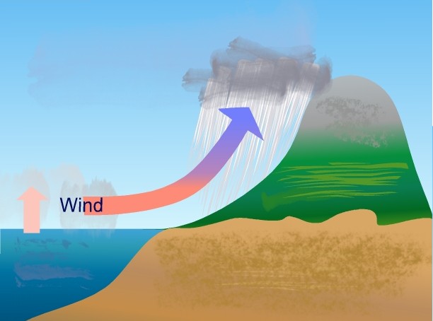
Orographic precipitation, also known as relief precipitation, is precipitation generated by a forced upward movement of air upon encountering a physiographic upland (see anabatic wind). This lifting can be caused by:
- Upward deflection of large-scale horizontal flow by the orography.
- Anabatic or upward vertical propagation of moist air up an orographic slope, caused by daytime heating of the mountain barrier surface.
Upon ascent, the air that is being lifted expands and cools adiabatically. This adiabatic cooling of a rising moist air parcel may lower its temperature to its dew point, thus allowing for condensation of the water vapor contained within it, and hence the formation of a cloud. If enough water vapor condenses into cloud droplets, these droplets may become large enough to fall to the ground as precipitation.
Terrain-induced precipitation is a major factor for meteorologists to consider when they forecast the local weather. Orography can play a major role in determining the type, amount, intensity, and duration of precipitation events. Researchers have discovered that barrier width, slope steepness, and updraft speed are major contributors when it comes to achieving the optimal amount and intensity of orographic precipitation. Computer models simulating these factors have shown that narrow barriers and steeper slopes produce stronger updraft speeds, which in turn increase orographic precipitation.
Orographic precipitation is known to occur on oceanic islands, such as the Hawaiian Islands and New Zealand; much of the rainfall received on such islands is on the windward side, and the leeward side tends to be quite dry, almost desert-like. This phenomenon results in substantial local gradients in the amount of average rainfall, with coastal areas receiving on the order of 20 to per year, and interior uplands receiving over 100 in per year. Leeward coastal areas are especially dry—less than 20 in per year at Waikiki—and the tops of moderately high uplands are especially wet—about 475 in per year at Waialeale on Kauai.
Another area in which orographic precipitation is known to occur is the Pennines in the north of England: the west side of the Pennines receives more rain than the east because the clouds are forced up and over the hills and cause the rain to tend to fall on the western slopes. This is particularly noticeable between Manchester (to the west) and Leeds (to the east); Leeds receives less rain due to a rain shadow of 12 mi from the Pennines.
Citations
General and cited references
References
- {{Cite EB1911
- link. (27 September 2007 ). [[American Meteorological Society]].)
- "Map of the Southern Half of Eastern Siberia and Parts of Mongolia, Manchuria, and Sakhalin: For a General Sketch of the Orography of Eastern Siberia". World Digital Library.
- Srinivasan, J., Nanjundiah, Ravi S. and Chakraborty, Arindam (2005). [http://hdl.handle.net/2005/76 "Impact of Orography on the Simulation of Monsoon Climate in a General Circulation Model"]. Indian Institute of Science.
This article was imported from Wikipedia and is available under the Creative Commons Attribution-ShareAlike 4.0 License. Content has been adapted to SurfDoc format. Original contributors can be found on the article history page.
Ask Mako anything about Orography — get instant answers, deeper analysis, and related topics.
Research with MakoFree with your Surf account
Create a free account to save articles, ask Mako questions, and organize your research.
Sign up freeThis content may have been generated or modified by AI. CloudSurf Software LLC is not responsible for the accuracy, completeness, or reliability of AI-generated content. Always verify important information from primary sources.
Report