From Surf Wiki (app.surf) — the open knowledge base
Orange River
Major river in southern Africa

Major river in southern Africa
| Field | Value |
|---|---|
| name | Orange River |
| native_name | Garip |
| name_other | Kai Garib (Groote Rivier), Gariep, Senqu, Oranje, Igqili( isiZulu and isiiXhosa) |
| image | OrangeRiverUpington.jpg |
| image_size | 300 |
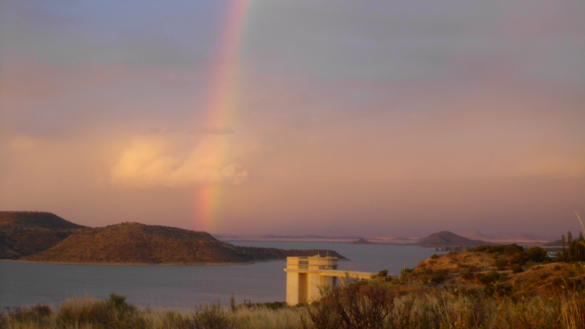
| image_caption | Sunset over the Orange River near Upington in the Northern Cape |
| mapframe | yes |
| mapframe-zoom | 4 |
| mapframe-point | none |
| map_size | 300 |
| pushpin_map_caption | |
| subdivision_type1 | Country |
| subdivision_name1 | Lesotho, South Africa, Namibia |
| subdivision_type2 | District |
| subdivision_name2 | Mokhotlong |
| subdivision_type3 | District |
| subdivision_name3 | Thaba-Tseka |
| subdivision_type4 | District |
| subdivision_name4 | Qacha's Nek, |
| subdivision_name5 | |
| length | 2432 km |
| discharge1_avg | 365 m3/s |
| discharge1_max | |
| source1 | Mont-aux-Sources |
| source1_location | Maloti Mountains (Drakensberg), Lesotho |
| source1_coordinates | |
| source1_elevation | 3350 m |
| mouth | Alexander Bay |
| mouth_location | Atlantic Ocean |
| mouth_coordinates | |
| basin_size | 973000 km2 |
| tributaries_right | Caledon River, Vaal River, Fish River (Namibia) |
| custom_data | {{Designation list |
| embed | yes |
| designation1 | Ramsar |
| designation1_offname | Orange River Mouth (Namibia) |
| designation1_date | 23 August 1995 |
| designation1_number | 744 |
| designation2 | Ramsar |
| designation2_offname | Orange River Mouth (South Africa) |
| designation2_date | 28 June 1991 |
| designation2_number | 526 |
| mapframe-zoom = 4 | mapframe-point = none Quthing, Mohale's Hoek
The Orange River (from Afrikaans/Dutch: Oranjerivier) is a river in Southern Africa. It is the longest river in South Africa. With a total length of 2432 km, the Orange River Basin extends from Lesotho into South Africa and Namibia to the north. It rises in the Drakensberg mountains in Lesotho, flowing westwards through South Africa to the Atlantic Ocean. The river forms part of the international borders between South Africa and Lesotho and between South Africa and Namibia, as well as several provincial borders within South Africa. Except for Upington, it does not pass through any major cities. The Orange River plays an important role in the South African economy by providing water for irrigation and hydroelectric power. The river was named the Orange River in honour of the Dutch ruling family, the House of Orange, by the Dutch explorer Robert Jacob Gordon. Other names include simply the word for river, in Khoekhoegowab orthography written as !Garib, which is rendered in Afrikaans as Gariep River with the intrusion of a velar fricative in place of the alveolar click, Groote River (derived from Kai !Garib) or Senqu River (used in Lesotho), derived from ǂNū "Black". It is known in isiZulu as isAngqu.
Course
The Orange rises in the Drakensberg mountains along the border between South Africa and Lesotho, about 193 km west of the Indian Ocean and at an altitude of over 3,000 m. The extremity of the Orange River inside Lesotho is known as the Senqu. Parts of the Senqu River freeze in winter because of the high altitude. This creates droughts downstream, which mainly affect goat and cattle production.


The Orange River then runs westward through South Africa, forming the south-western boundary of the Free State province. In this section, the river flows first into the Gariep Dam and later into the Vanderkloof Dam. From the border of Lesotho to below the Vanderkloof Dam, the river bed is deeply incised. Further downstream, the land is flatter, and the river is used extensively for irrigation.
At the western point of the Free State, southwest of Kimberley, the Orange meets with its main tributary, the Vaal River, which forms much of the northern border of the province. From here, the river flows further westward through the arid wilderness of the southern Kalahari region and Namaqualand in the Northern Cape province to meet with Namibia at 20°E longitude. From here, it flows westward for 550 km, forming the international border between the province and Namibia's ǁKaras Region. On the border, the river passes the town of Vioolsdrif, the main border post between South Africa and Namibia.
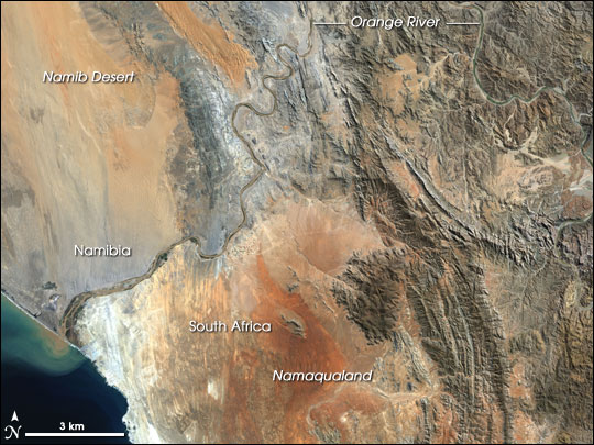
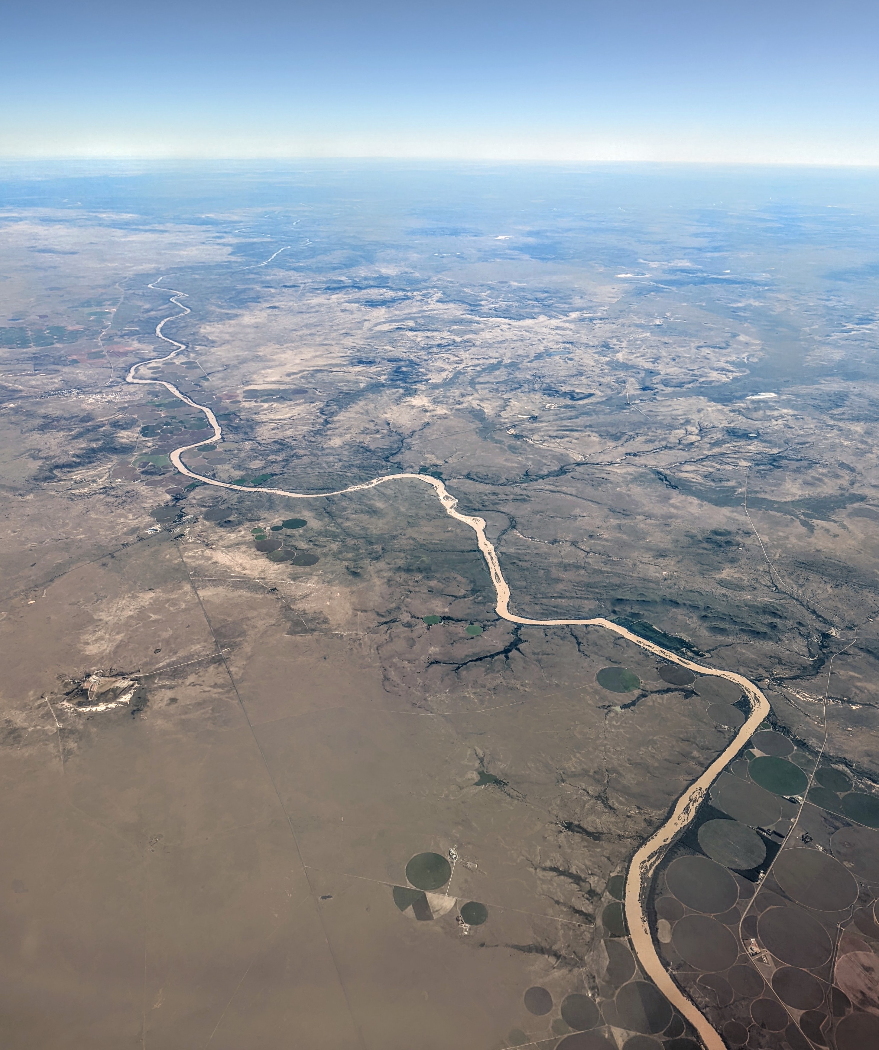
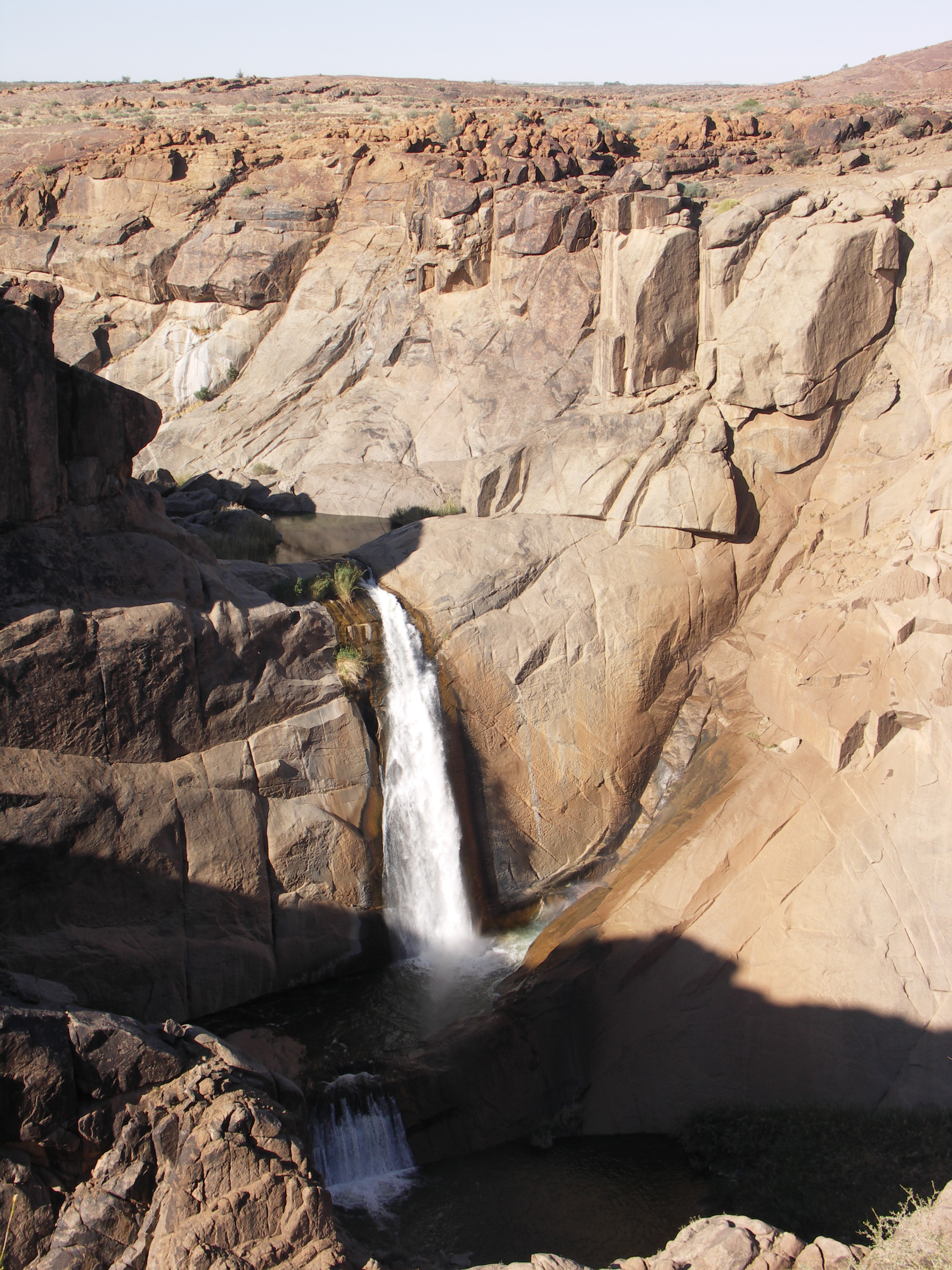
In the last 800 km of its course, the Orange receives many intermittent streams (such as the Fish River), and several large wadis lead into it. In this section, the Namib Desert terminates on the north bank of the river, so under normal circumstances, the volume of water added by these tributaries is negligible. Here, the bed of the river is once again deeply incised. The Augrabies Falls are located on this section of the Orange, where the river descends 122 m in a course of 26 km.
The Orange empties into the Atlantic Ocean between the small towns of Oranjemund (meaning "Orange mouth") in Namibia and Alexander Bay in South Africa, about equidistant between Walvis Bay and Cape Town. Some 33 km from its mouth, it is obstructed by rapids and sand bars and is generally not navigable for long stretches.
The river has a total length of 2432 km.
Catchment and rainfall

In the dry season, the volume of the water in the river is considerably reduced because of the rapid run-off and evaporation. At the source of the Orange, the rainfall is about 2,000 mm per annum, but precipitation decreases as the river flows westward; at its mouth, the rainfall is less than 50 mm per year. The factors that support evaporation, though, tend to increase in a westerly direction. In the wet season (summer), the Orange river becomes a brown coloured torrent. The huge mass of sediment carried constitutes a long-term threat to engineering projects on the river.
The total catchment of the Orange River (including the Vaal) extends over 973,000 km2, i.e. equivalent to about 77% of the land area of South Africa (1,221,037 km2). Around 366,000 km2 (38%), however, are situated outside the country in Lesotho, Botswana, and Namibia.
Tributaries
- Vaal River - 1,458 km
- Caledon River - 642 km
- Khubelu River - 144 km
Dams
- Armenia Dam
- Egmont Dam
- Gariep Dam
- Newberry Dam
- Vanderkloof Dam
- Welbedacht Dam
History
Etymology
Some of the earliest precolonial inhabitants called the river ǂNūǃarib, referring to its black colour, or sometimes just Kai !Arib ("Great River"), from which is derived the Afrikaans version Gariep, and translation "Groote Rivier". The early Dutch name for the river was just that translation, Groote Rivier, meaning "Great River". The river was named the Orange River by Colonel Robert Gordon, commander of the United East India Company (VOC) garrison at Cape Town, on a trip to the interior in 1779. Gordon named the river in honor of William V of Orange. A popular but incorrect belief is that the river was named after the supposedly orange color of its water, as opposed to the color of its tributary, the Vaal River, which name is derived from the name ǀHaiǃarib "pale river" (vaal being Afrikaans for pale or grey). Since the end of apartheid, the name "Gariep" has had greater favour in official correspondence in South Africa, although the name "Orange" has greater international recognition. In Lesotho, where the river rises, it is known as the Senqu River, derived from the original Khoemana name.

The Grootslang
In South African folklore, the Orange River is often associated with the Grootslang, a mythical being resembling a giant serpent, which is often connected to the river's alluvial diamonds. The Grootslang is described as living in a gem-filled cave connected to the Orange River by a natural pipe through which the diamonds gradually enter the river. Other sites said to be lairs of the creature include the pool beneath the King George Cataract at Aughrabies Falls, which is also said to be a source of diamonds, and a large rock in the middle of the river itself. In this version of the legend, the Grootslang is also said to prey on cattle from the river's banks.
Economy

As the collection point for the majority of South Africa's water, the Orange River plays a major role in supporting agriculture, industry, and mining. To assist in this, two large water schemes have been created, the Orange River Project and the Lesotho Highlands Water Project. Historically, the river played an important role in the South African diamond rush, with the first diamonds in the country being discovered in alluvial deposits on the Orange. Today, several commercial diamond mines operate along the final stretch of the Orange River and around its mouth.
Because of the lack of dangerous animals and high water levels during summer, the river is used for recreational canoeing and rafting. Orange River rafting has become very popular with many companies using their camps along the river from which to operate. The most popular trips are four-day and six-day river trips that take place either along the gorge below the Augrabies Falls or along the Richtersveld area.
Orange River Project
The Orange River Project (ORP) was one of the largest and most imaginative projects of its kind in South Africa. It was constructed by Hendrik Verwoerd's government at the height of the apartheid era. The ORP was built to exploit the waters of the Orange River—which, without the Vaal River, represents some 14.1% of the total runoff in South Africa—and in the process, to satisfy an increasing demand for water. The main objectives of the project were:
- to stabilise river flow,
- the generation and transmission of hydroelectric power,
- to provide a reliable water supply for users in the Orange River basin, and
- to give a new lease on life to water-deficient areas in the Eastern Cape, such as the Great Fish and Sundays River valleys.
The Gariep Dam near Colesberg is the main storage structure within the Orange River. From here, the water is supplied in two directions, westward along the Orange River (via hydroelectric power generators) to the Vanderkloof Dam and southward through the Orange-Fish Tunnel to the Eastern Cape.

Hydroelectricity
Eskom operates hydroelectric power stations at both the Gariep Dam and the Vanderkloof Dam. The hydroelectric power station at the Vanderkloof Dam was the first power-generation station in South Africa situated entirely underground. The towns Oviston and Oranjekrag were established to facilitate the construction and operation of the new infrastructure.
Irrigation


Irrigation in the vast area downstream of the Vanderkloof Dam, which has turned thousands of hectares of arid veld into highly productive agricultural land, was made possible by the construction of the Gariep and Vanderkloof Dams. Old established irrigation schemes such as those at Buchuberg, Upington, Kakamas, and Vioolsdrif have also benefitted because regulation of the flow is now possible. On the Namibian side of the river, Aussenkehr produces grapes with the help of water from the Orange.
In recent years, the wine-producing areas along the Orange River have grown in importance. Irrigation in the Eastern Cape has also received a tremendous boost, not only from the additional water being made available, but also owing to improvement in water quality. Without this improvement, the citrus farmers along the Lower Sundays River would almost certainly have continued to suffer losses of productivity.
Lesotho Highlands Water Project
The Lesotho Highlands Water Project was conceived to supplement the water supply in the Vaal River System. Water is delivered to South Africa by means of the delivery tunnel which passes under the Lesotho South Africa border at the Caledon River, and then under the Little Caledon River south of Clarens in the Free State, and discharges into the Ash River about 30 km further to the north. The scheme became viable when water demands in Gauteng reached levels that could no longer be supported economically by alternative schemes such as the Tugela River-Vaal River pumped storage scheme, which used the Sterkfontein Dam, located near Harrismith in the Free State.
Alluvial diamonds
In 1867, the first diamond discovered in South Africa, the Eureka Diamond, was found near Hopetown on the Orange River. Two years later, a much larger diamond known as the Star of South Africa was found in the same area, causing a diamond rush. This was soon eclipsed by the diamond rush to mine diamonds directly from kimberlite at Kimberley in 1871, although alluvial diamonds continued to be found in the Orange. Today, several commercial diamond mines operate on the last stretch of the river, as well as the beaches around its mouth. Diamond mines also operate on the middle stretch of the river.
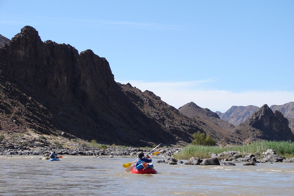
Rafting and canoeing
During the temperate months of March and April, given good rains and the sluices of the dams being open, a canoeist (or rafter) can easily travel 30 km per day. The lower reaches of the river are most popular, because of the spectacular topography. Commercial tours are available, and these expeditions depart from the border town of Vioolsdrif.
Wildlife
The Orange River has no large animals. It lies outside the range of the Nile crocodile, and although hippopotami were once abundant, they were hunted to extermination in the 19th century. The Orange River has a relative paucity of species diversity. Surveys from 1995 to 2001 in the Lower Orange River found 19 different fish species from eight different families. The two non-native species recorded in the surveys were Cyprinus carpio and Oreochromis mossambicus, the latter of which had increased rapidly in abundance since the early 1980s. Another exotic species, rainbow trout, is found in the river headwaters in Lesotho.[[Image:Labeobarbus aeneus, Orange river, Richtersveld.jpg|thumb|upright=1.15|The smallmouth yellowfish (Labeobarbus aeneus) is a popular [[Recreational fishing|sport fish]] endemic to the Orange-Vaal River system.]] Seven species are endemic to the Vaal-Orange River system:
- Rock-catfish (Austroglanis sclateri)
- Maluti redfin or Maloti minnow (Pseudobarbus quathlambae)
- Namaquab barb (Barbus hospes)
- River sardine (Mesobola brevianalis)
- Smallmouth yellowfish (Labeobarbus aeneus)
- Largemouth yellowfish (Labeobarbus kimberlyensis)
- Orange River Mudfish (Labeo capensis)
References
References
- [http://myfundi.co.za/e/Key_rivers_of_South_Africa Key rivers of South Africa ] {{webarchive. link. (10 July 2012)
- Travel, Wild Africa. "Wild Africa Travel: Orange River".
- "Orange River Basin".
- Doke, C.M. (1972). "Zulu-English Dictionary". Witwatersrand University Press.
- link. (17 March 2007, ''World Resources Institute'', {{ISBN). 1-56973-254-X
- (April 2020)
- the surrounding area was once known as "Transgariep" ("the land across the Gariep") but the name has long been obsolete. See Karel Schoeman, ''Early White Travellers in the Transgariep, 1819-1840'', Protea Boekhuis, 2012 ({{ISBN. 9781869190163)
- Earle, Anton et al. (2005), [http://www.acwr.co.za/pdf_files/05.pdf A preliminary basin profile of the Orange/Senqu River (pdf)] {{Webarchive. link. (28 February 2008 , ''African Centre for Water Research'', retrieved 30 June 2007)
- (13 June 2013). "New name looms for NC River". Diamond Fields Advertiser.
- (6 June 2013). "Statement by Afriforum on proposed name change of Orange River". Polity.
- Green, Lawrence G.. (1948). "Where Men Still Dream". Standard Press Ltd., Cape Town.
- Cornell, F. C.. (1920). "The Glamour of Prospecting". T. Fisher Unwin Ltd., London.
- (2007). "Fish populations, gill net catches and gill net selectivity in the Lower Orange River, Namibia, from 1995 to 2001". NINR.
- Beekman, Hans E.. (2006-05-30). "Facing the Facts: Assessing the Vulnerability of Africa's Water Resources to Environmental Change". UNEP/Earthprint.
- (1981). "Utilising South Africa's largest river: The physiographic background to the Orange River scheme". GeoJournal.
- "Orange River Mouth - Namibia".
- "Orange River Mouth - South Africa".
- (2012). "Historical Dictionary of Namibia". Scarecrow Press.
- Shortridge, Guy Chester. (1934). "The Mammals of South West Africa: A Biological Account of the Forms Occurring in that Region". W. Heinemann.
This article was imported from Wikipedia and is available under the Creative Commons Attribution-ShareAlike 4.0 License. Content has been adapted to SurfDoc format. Original contributors can be found on the article history page.
Ask Mako anything about Orange River — get instant answers, deeper analysis, and related topics.
Research with MakoFree with your Surf account
Create a free account to save articles, ask Mako questions, and organize your research.
Sign up freeThis content may have been generated or modified by AI. CloudSurf Software LLC is not responsible for the accuracy, completeness, or reliability of AI-generated content. Always verify important information from primary sources.
Report