From Surf Wiki (app.surf) — the open knowledge base
Opperdoes
| Field | Value |
|---|---|
| name | Opperdoes |
| settlement_type | Village |
| other_name | |
| native_name | |
| native_name_lang | nl |
| image_skyline | Opperdoes2.jpg |
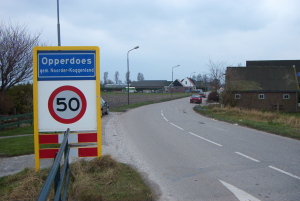
| image_caption | Typical Opperdoes street |
| image_flag | Opperdoes_vlag_2008.svg |
| image_shield | Opperdoes wapen.svg |
| image_map | Locatie Medemblik.svg |
| image_map1 | Map NL - Noorder-Koggenland - Opperdoes.png |
| map_caption1 | The village centre (dark green) and the statistical district (light green) of Opperdoes in the municipality of Medemblik. |
| pushpin_map | Netherlands#Netherlands North Holland |
| pushpin_label_position | top |
| pushpin_mapsize | 250 |
| pushpin_map_caption | Location in the Netherlands##Location in the province of North Holland in the Netherlands |
| subdivision_type | Country |
| subdivision_name | Netherlands |
| subdivision_type1 | Province |
| subdivision_name1 | North Holland |
| subdivision_type2 | Municipality |
| subdivision_name2 | Medemblik |
| elevation_footnotes | |
| elevation_m | -0.8 |
| area_footnotes | |
| area_total_km2 | 3.28 |
| population_footnotes | |
| population_total | 1,930 |
| population_as_of | 2021 |
| population_density_km2 | auto |
| timezone | CET |
| utc_offset | +1 |
| timezone_DST | CEST |
| utc_offset_DST | +2 |
| postal_code_type | Postal code |
| postal_code | 1674 |
| area_code_type | Dialing code |
| area_code | 0227 |
| coordinates |
-- Opperdoes is a village in the Dutch province of North Holland. It is a part of the municipality of Medemblik, and lies about 12 km north of Hoorn. It has a certain fame for its local variety of potatoes, "Opperdoezer Ronde".
The village was first mentioned in the late 11th century as Those, and means "bog with moss". Opper (upper) could have been added to distinguish from Nederdoes, a village lost in the Zuiderzee.
History
The exact age of the village of Opperdoes is hard to determine. The village used to be located very close to the sea, and the area has been flooded several times. Initial settlements seem to have been abandoned after the year 300 because of large floods. New villages were later built on terps.
Opperdoes used to be located 4 or 5 kilometres from the sea-dike that existed around 781. However, the dike was in a very bad condition and in 1318 Willem van Henegouwen, the ruler, agreed the build a new dike. In 1334 a new dike was built between Medemblik and Barsingerhorn.
The new dike was built 4 kilometres southwards of the old one and Almersdorp, a village, was left outside the new dike.
In 1517 the old church of Opperdoes and many buildings were destroyed by Grote Pier and his Frisian army, the Gelderse Friezen.
A new church was built, and it was ready in 1530. The top of the tower of the church was replaced in 1838, after it was destroyed in a storm in November 1836.
Opperdoes was a separate municipality between 1817 and 1979, when the new municipality of Noorder-Koggenland was created.
Important buildings and locations
A touristic attraction is the old steam railway station on the railway between Hoorn and Medemblik.
Religion
Religion has played an important part in the village in the last two centuries. Opperdoes is considered an orthodox village in a fairly liberal minded area. In earlier times the villagers of Opperdoes were called the Turks: they were a particularly free-minded people, in line with the other villages in the area, that enjoyed life to the fullest.
Around 1822 Jan Mazereeuw, the so-called Profete of Opperdoes, preached in the village. He was a farmer and had been mayor of the village for a while during the French occupation. He called the Reformed Church a godless temple and preached a very sober lifestyle. Although he never had a large crowd of followers, it is generally assumed that a part of the village's orthodoxy can be explained by his preachings.
Statistics
In 2001, the village centre of Opperdoes had 1442 inhabitants. The built-up area of the village was 0.31 km2, and contained 555 residences. The wider statistical area of Opperdoes has a population of around 1750.
References
- Het dorp Opperdoes, J. Z. Maartenszoon, Repro Holland, 1973
- Abraham Jacob van der Aa, "Aardrijkskundig woordenboek der Nederlanden", 1839–1851
References
- "Postcodetool for 1674MA". Het Waterschapshuis.
- "Kerncijfers wijken en buurten 2021".
- "Opperdoes - (geografische naam)".
- {{Repertorium Nederlandse Gemeenten
- Statistics Netherlands (CBS), ''Bevolkingskernen in Nederland 2001'' [http://www.cbs.nl/nl-NL/menu/themas/milieu-natuur-ruimte/ruimte/publicaties/cartografie-geografie/geografische-data/2001-bevolkingskernen-in-nederland.htm] {{Webarchive. link. (2007-01-24 . Statistics are for the continuous built-up area.)
- Statistics Netherlands (CBS), ''Gemeente Op Maat 2004: Noorder-Koggenland'' [http://www.cbs.nl/nl-NL/menu/themas/nederland-regionaal/nederland-regionaal/publicaties/gemeente-op-maat/2004/alfabet/N/2004-noorder-koggenland.htm]{{dead link. (November 2017)
This article was imported from Wikipedia and is available under the Creative Commons Attribution-ShareAlike 4.0 License. Content has been adapted to SurfDoc format. Original contributors can be found on the article history page.
Ask Mako anything about Opperdoes — get instant answers, deeper analysis, and related topics.
Research with MakoFree with your Surf account
Create a free account to save articles, ask Mako questions, and organize your research.
Sign up freeThis content may have been generated or modified by AI. CloudSurf Software LLC is not responsible for the accuracy, completeness, or reliability of AI-generated content. Always verify important information from primary sources.
Report