From Surf Wiki (app.surf) — the open knowledge base
Northeast Texas
| Field | Value | |
|---|---|---|
| name | Northeast Texas | |
| native_name | ||
| native_name_lang | ||
| settlement_type | Region | |
| <!-- images, nickname, motto --> | image_skyline | {{multiple image |
| total_width | 290px | |
| perrow | 2/2/1/2 | |
| border | infobox | |
| image1 | Tyler May 2016 06 (Plaza Tower).jpg | |
| image2 | N Broadway Ave looking south from railroad bridge, Tyler, Texas.jpg | |
| image3 | Downtown Longview - 29195600114.jpg | |
| image4 | Texarkana April 2016 114 (State Line Avenue).jpg | |
| image5 | Paris Commercial Historic District Wiki (1 of 1).jpg | |
| image6 | Downtown Palestine Wiki 4.jpg | |
| image7 | Downtown Marshall Wiki (1 of 1).jpg | |
| image_caption | From top, left to right: Plaza Tower in Tyler; North Broadway Avenue in Tyler; Downtown Longview; State Line Avenue in Texarkana; Paris Commercial Historic District; Downtown Palestine; Downtown Marshall; and Downtown Kilgore | |
| image_shield | ||
| image_map | North East Texas.png | |
| map_caption | Northeast Texas counties in red | |
| coordinates | ||
| subdivision_type | Country | |
| subdivision_name | United States | |
| subdivision_type1 | State | |
| subdivision_name1 | Texas | |
| subdivision_type2 | Largest city | |
| subdivision_name2 | Tyler | |
| established_title | ||
| leader_name | ||
| area_total_km2 | ||
| area_total_sq_mi | ||
| area_water_sq_mi | ||
| elevation_footnotes | tags -- | |
| elevation_min_ft | ||
| population_footnotes | tags -- | |
| population_total | 1,152,223 | |
| population_as_of | 2020 | |
| population_density_km2 | ||
| population_density_sq_mi | ||
| utc_offset1_DST | ||
| postal_code_type | ||
| area_code_type | ||
| area_code | ||
| website |
Northeast Texas is a cultural and geographic region in the northeast corner of the U.S. state of Texas. Geographically centered on two metropolitan areas strung along Interstate 20—Tyler in the west and Kilgore, Longview, Marshall to the east, the areas of Greenville, Mount Pleasant, Sulphur Springs, Paris, and Texarkana in the north primarily along Interstate 30, and Jacksonville and Palestine to the south are also major cities within the region. Most of Northeast Texas is included in the interstate region of the Ark-La-Tex. [[File:MarshallCourthouse.JPG|thumb|right|200px|The Old Courthouse in Marshall during the Wonderland of Lights, the largest light festival in Northeast Texas: Tourism is one of Northeast Texas's most important industries.]]
The region is unique in that it is the only portion of East Texas that is not within the direct sphere of influence of either Dallas/Fort Worth or Houston. This generally weakens the area's visibility as areas in the far south ally themselves with Houston and areas to the west ally themselves with Dallas. These areas are on the fringe of those cities' spheres of influence, so are not as visible as smaller cities such as Grapevine or Deer Park, which are closer to the respective centers of power.
In the mid-19th century, Marshall and Jefferson constituted a sphere of influence that led the entire state into the Confederate States of America, and during the Mexican and Republic periods, Nacogdoches and San Augustine were the most developed and influential cities in Northeast Texas. Nacogdoches rebelled against Mexican rule in the Fredonian Rebellion and had one of the first newspapers to run the phrase Remember the Alamo!; while none of these three cities is a major population center in its own right on the state level any longer, all four are still major cultural centers, with Nacogdoches and Tyler being well-established centers of higher learning. Many of the largest cities in Northeast Texas still follow a rural Southern way of life, especially in dialect, mannerisms, religion, and cuisine.
Geography
The geography of Northeast Texas is composed mainly of the Piney Woods, a mixed forest of deciduous and conifer flora. The Piney Woods cover 23500 sqmi of gently rolling or hilly forested land. These woods are part of a much larger region of pine-hardwood forest that extends into Louisiana, Arkansas, and Oklahoma. Northeast Texas lies within the Gulf Coastal Plain and receives more rainfall, 35 to 50 in (890 to 1270 mm), than the rest of Texas.
The Sabine River is the major river in Northeast Texas, and flows through Longview and several other cities. The Red River also flows through the region and forms the northern border with Oklahoma and a portion of Arkansas. In Northeast Texas and the rest of South, small rivers and creeks collect into swamps called "bayous" and merge with the surrounding forest. Bald cypress and Spanish moss are the dominant plants in bayous. The most famous of these bayous in Northeast Texas is the Cypress Bayou surrounding the Big, Little, and Black Cypress Rivers around Jefferson. They flow east into Caddo Lake and the adjoining wetlands cover the rim and islands of the lake.
Some of the major lakes in the area include: Jim Chapman Lake, Lake Tawakoni, Lake Fork, Cedar Creek Reservoir, Pat Mayse Lake, Lake Palestine, Caddo Lake, Lake O' the Pines, and Wright Patman Lake.
The climate of the region is warmer and wetter than most of Texas and its geography is more hilly and forested. Its culture is similar to that of Southeast Texas, but does not have as much of a Cajun influence.
Counties
According to Visit Northeast Texas, the following counties are considered to be part of Northeast Texas:
- Anderson
- Bowie
- Camp
- Cass
- Cherokee
- Delta
- Fannin
- Franklin
- Gregg
- Harrison
- Henderson
- Hopkins
- Hunt
- Lamar
- Marion
- Morris
- Panola
- Rains
- Red River
- Rusk
- Smith
- Titus
- Upshur
- Van Zandt
- Wood
Largest cities
| City | Population (2020) | ||||
|---|---|---|---|---|---|
| [[File:Tyler May 2016 42 (People's Petroleum Building and Plaza Tower).jpg | 120x120px]] | ||||
| Tyler | 105,995 | ||||
| [[File:Downtown Longview - 29195600114.jpg | 120x120px]] | ||||
| Longview | 81,638 | ||||
| [[File:Texarkana April 2016 114 (State Line Avenue).jpg | 120x120px]] | ||||
| Texarkana | 36,193 | ||||
| [[File:Greenville August 2015 23 (Greenville Municipal Auditorium).jpg | 120px]] | ||||
| Greenville | 28,164 | ||||
| [[File:DowntownParis,Texas.jpg | 120px]] | ||||
| Paris | title=U.S. Census Bureau QuickFacts: Jacksonville city, Texas; Sulphur Springs city, Texas; Mount Pleasant city, Texas; Palestine city, Texas; Marshall city, Texas; Paris city, Texas | url=https://www.census.gov/quickfacts/fact/table/jacksonvillecitytexas,sulphurspringscitytexas,mountpleasantcitytexas,palestinecitytexas,marshallcitytexas,pariscitytexas/PST045221 | access-date=2022-04-19 | website=U.S. Census Bureau | language=en}} |
| [[File:Marshall October 2016 03 (Washington Avenue).jpg | 120x120px]] | ||||
| Marshall | 23,392 | ||||
| [[File:Dilley Building Palestine Wiki (1 of 1).jpg | 120x120px]] | ||||
| Palestine | 18,544 | ||||
| [[File:Dr. Pepper beverage advertising sign on a building in downtown Mount Pleasant, Texas LCCN2014630245.tif | 120px]] | ||||
| Mount Pleasant | 16,047 | ||||
| [[File:SS Courthouse Bench.jpg | 120px]] | ||||
| Sulphur Springs | 15,941 | ||||
| [[File:Capital One Bank, Jacksonville, TX IMG 3002.JPG | 120px]] | ||||
| Jacksonville | 13,997 | ||||
| [[File:Kilgore May 2016 08 (Kilgore Street).jpg | 120x120px]] | ||||
| Kilgore | title=U.S. Census Bureau QuickFacts: Athens city, Texas; Kilgore city, Texas; Henderson city, Texas | url=https://www.census.gov/quickfacts/fact/table/athenscitytexas,kilgorecitytexas,hendersoncitytexas/PST045221 | access-date=2022-04-19 | website=U.S. Census Bureau | language=en}} |
| [[File:Another look at downtown Henderson, TX IMG 2975.JPG | 120px]] | ||||
| Henderson | 13,271 | ||||
| [[File:Athens October 2017 03 (E Tyler Street).jpg | 120x120px]] | ||||
| Athens | 12,857 |
Culture
.jpg)
Culturally, Northeast Texas is more closely akin to Arkansas, Northern Louisiana, and even Mississippi than it is to West Texas. Northeast Texas is in the Bible Belt creating a strong Fundamentalist Christian sentiment. During the Civil Rights movement several communities clashed over integration. In presidential elections since 1950, both Smith County (county seat Tyler) and Gregg County (county seat Longview) have been reliably Republican.
Much of modern Northeast Texas culture has its roots in traditions that go back for generations. First Monday Trade Days is a monthly flea market held in Canton, Texas. The market is actually held on the Thursday through Sunday preceding the first Monday of each month. It purports to be the largest and oldest continually operated flea market in the United States, and is a popular event in the area.
The East Texas Oil Museum, located on the campus of Kilgore College in Kilgore, Texas, houses the authentic recreation of oil discovery and production in the early 1930s from the largest oil field inside U.S. boundaries.
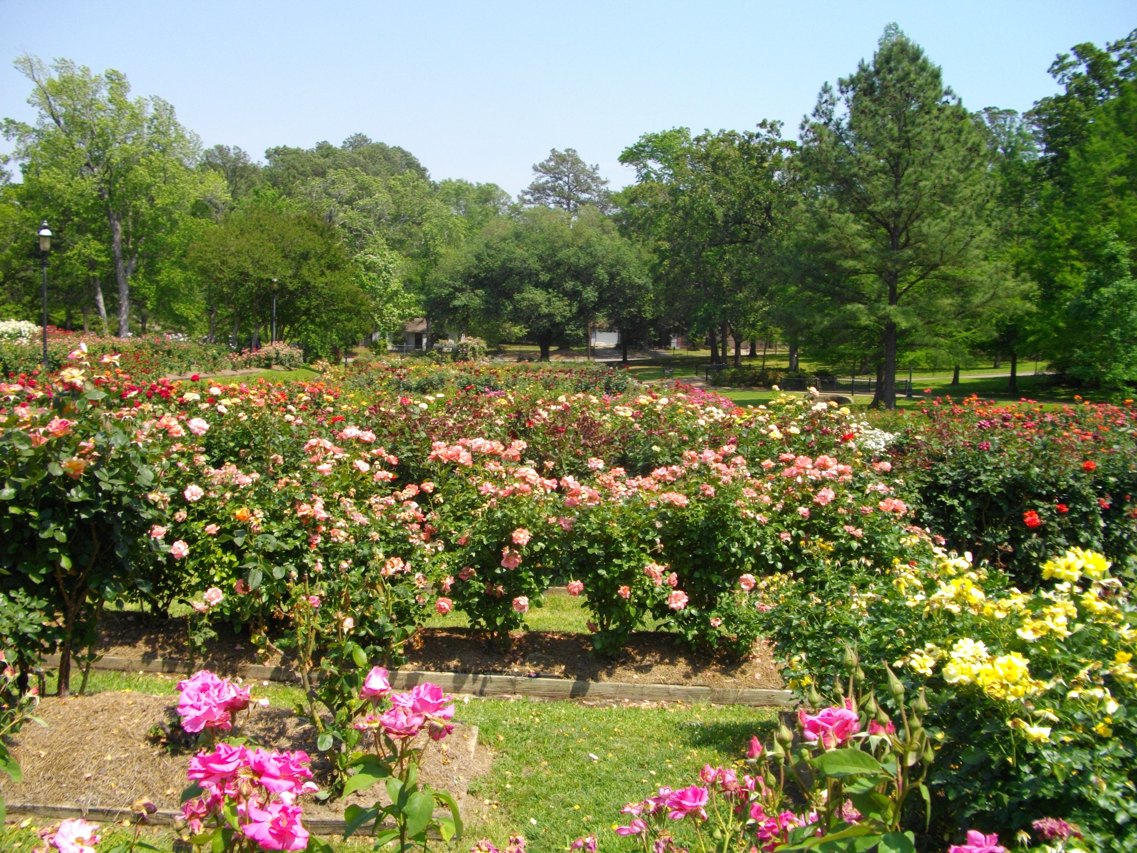
Tyler has a rich culture and has been nicknamed the "Rose Capital of America" because of its large role in the rose-growing industry; about 20% of commercial rose bushes produced in the U.S. are grown in Tyler and Smith counties and more than half of the rose bushes are packaged and shipped from the area. It boasts the nation's largest municipal rose garden and hosts the Texas Rose Festival each October, which draws more than 100,000 spectators annually and has garnered nationwide attention.
The Northeast Texas Children's Museum is located in Commerce. The museum provides playful and creative learning experiences for children in the Northeast Texas area. Many school districts from the Dallas/Fort Worth Metroplex and the Northeast Texas area take field trips to the museum.
The Audie Murphy American Cotton Museum, located in Greenville, is dedicated to military veterans and showcases various exhibits and displays. Medal of Honor recipient Audie Murphy, born in Hunt County and worked in Greenville before entering the military, is honored at the museum. The museum also showcases cotton, as cotton was Hunt County's largest cash crop in the early 20th century, and the museum features a "History of Cotton" exhibit.
Economy
The economy of Northeast Texas is primarily centered within the Tyler and Longview metropolitan statistical areas, the latter within the Ark-La-Tex region alongside the Texarkana metropolitan area. Within the Tyler and Longview conurbation, Brookshire Grocery Company operates as a multistate conglomerate owning Brookshire's and Super1Foods; other major corporations with a presence in the area include Synthesizers.com, Eastman Chemical, AAON Coil Products, AT&T, and Walmart.
Higher education
.jpg)
Northeast Texas has a number of higher-education institutions, including The University of Texas at Tyler, East Texas A&M University, Texas A&M University at Texarkana, Stephen F. Austin State University located in Nacogdoches, East Texas Baptist University, LeTourneau University, eight public and two private community colleges, a branch of the Texas State Technical College at Marshall, three historically black colleges, and a number of church-affiliated private institutions. The public colleges and universities of the region also collaboratively provide degree and course opportunities through the Northeast Texas Consortium of Colleges and Universities.
The community colleges of Northeast Texas share a history of emerging from the "junior college" movement of schools focused on providing the first two years of the college degree. Although most added technical programs with associate of applied science degrees following the community college movement of the 1960s, the schools still place a strong emphasis on liberal arts and the academic associate of arts and associate of science degree programs. They often include the full range of college sports, including football, and host dormitories, and are known for their "high kicking" drill teams. Community colleges in the region include Kilgore College, Paris Junior College, Northeast Texas Community College near Mt. Pleasant, Texarkana College, Panola College in Carthage, Tyler Junior College, Trinity Valley Community College in Athens and with campuses in Terrell and Palestine, and Angelina College in Lufkin. Jacksonville hosts the two smaller private two-year colleges of the region, Jacksonville College (Baptist) and Lon Morris College.
Transportation

- [[File:I-20 (TX).svg|25px]] Interstate 20
- [[File:I-30 (TX).svg|25px]] Interstate 30
- [[File:I-369 (TX).svg|30px]] Interstate 369
- [[File:US 59.svg|25px]] U.S. Highway 59
- [[File:US 67.svg|25px]] U.S. Highway 67
- [[File:US 69.svg|25px]] U.S. Highway 69
- [[File:US 79.svg|25px]] U.S. Highway 79
- [[File:US 80.svg|25px]] U.S. Highway 80
- [[File:US 82.svg|25px]] U.S. Highway 82
- [[File:US 84.svg|25px]] U.S. Highway 84
- [[File:US 175.svg|30px]] U.S. Highway 175
- [[File:US 259.svg|30px]] U.S. Highway 259
- [[File:US 271.svg|30px]] U.S. Highway 271
- [[File:US 287.svg|30px]] U.S. Highway 287
Footnotes
References
- "U.S. Census Bureau QuickFacts: Delta County, Texas; Cherokee County, Texas; Cass County, Texas; Camp County, Texas; Bowie County, Texas; Anderson County, Texas". Census.gov.
- "U.S. Census Bureau QuickFacts: Hopkins County, Texas; Henderson County, Texas; Harrison County, Texas; Gregg County, Texas; Franklin County, Texas; Delta County, Texas". Census.gov.
- "U.S. Census Bureau QuickFacts: Red River County, Texas; Rains County, Texas; Panola County, Texas; Morris County, Texas; Marion County, Texas; Lamar County, Texas". Census.gov.
- "U.S. Census Bureau QuickFacts: Wood County, Texas; Van Zandt County, Texas; Upshur County, Texas; Titus County, Texas; Smith County, Texas; Rusk County, Texas". Census.gov.
- "At the Heart of Texas: Tyler–Longview".
- Fox, Courtney. (2020-03-09). "Visit Texas, Arkansas and Louisiana at the Same Time at This Roadside Marker".
- "About Stephen F. Austin State University".
- "Colleges & Universities Near Tyler, Texas".
- (2018-02-15). "The Heart of East Texas: Piney Woods".
- "Piney Woods Forest." ''One Earth''. "The Piney Woods ecoregion occupies the West Gulf Coastal Plain and encompasses eastern Texas (including the “Big Thicket”) as well as western Louisiana, southwestern Arkansas, and a small portion of southeastern Oklahoma. It is separated from the Southeast US conifer savannas ecoregion by the Mississippi Alluvial Valley (the Mississippi Lowland Forests ecoregion)."
- "Sabine River".
- Visit Northeast Texas https://www.visitnortheasttexas.com/Home.html
- "U.S. Census Bureau QuickFacts: Tyler city, Texas".
- "U.S. Census Bureau QuickFacts: Longview city, Texas".
- "U.S. Census Bureau QuickFacts: Texarkana city, Texas".
- "U.S. Census Bureau QuickFacts: Greenville city, Texas".
- "U.S. Census Bureau QuickFacts: Jacksonville city, Texas; Sulphur Springs city, Texas; Mount Pleasant city, Texas; Palestine city, Texas; Marshall city, Texas; Paris city, Texas".
- "U.S. Census Bureau QuickFacts: Athens city, Texas; Kilgore city, Texas; Henderson city, Texas".
- Gal, Mark Abadi, Shayanne. "The US is split into more than a dozen 'belts' defined by industry, weather, and even health".
- "First Monday Canton {{!}} Canton, Texas {{!}} About".
- "History {{!}} East Texas Oil Museum".
- "VERIFY: Is Tyler the rose capital of the country?".
- Schechter, Alex. (2021-11-02). "The Rose Queen of Texas". The New York Times.
- "About Brookshire Grocery Company".
- "Eastman Chemical Company {{!}} Longview, Texas".
- "Take a tour of the HBCUs in Texas".
This article was imported from Wikipedia and is available under the Creative Commons Attribution-ShareAlike 4.0 License. Content has been adapted to SurfDoc format. Original contributors can be found on the article history page.
Ask Mako anything about Northeast Texas — get instant answers, deeper analysis, and related topics.
Research with MakoFree with your Surf account
Create a free account to save articles, ask Mako questions, and organize your research.
Sign up freeThis content may have been generated or modified by AI. CloudSurf Software LLC is not responsible for the accuracy, completeness, or reliability of AI-generated content. Always verify important information from primary sources.
Report