From Surf Wiki (app.surf) — the open knowledge base
North Frodingham
Village and civil parish in the East Riding of Yorkshire, England

Village and civil parish in the East Riding of Yorkshire, England
| Field | Value |
|---|---|
| country | England |
| coordinates | |
| label_position | left |
| official_name | North Frodingham |
| population | 830 |
| population_ref | (2011 census) |
| civil_parish | North Frodingham |
| unitary_england | East Riding of Yorkshire |
| region | Yorkshire and the Humber |
| lieutenancy_england | East Riding of Yorkshire |
| constituency_westminster | Bridlington and The Wolds |
| post_town | DRIFFIELD |
| postcode_district | YO25 |
| postcode_area | YO |
| dial_code | 01262 |
| os_grid_reference | TA101531 |
| london_distance_mi | 170 |
| london_direction | S |
North Frodingham is a village and civil parish in the East Riding of Yorkshire, England. It is situated approximately 5.5 mi south-east of the town of Driffield and lies on the B1249 road.
The civil parish is formed by the village of North Frodingham and the hamlets of Church End and Emmotland. According to the 2011 UK census, North Frodingham parish had a population of 830,{{NOMIS2011
The name Frodingham derives from the Old English Frodaingashām or Frodainghām, meaning 'settlement of Froda's people' or 'settlement at Froda's place'.
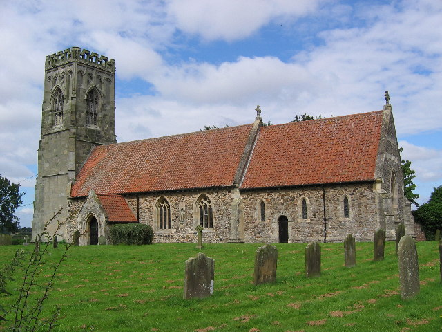
The Grade II* listed church of St Elgin, North Frodingham was restored in stages between 1877 and 1891 by Sir Tatton Sykes, 5th Baronet with the top part of the perpendicular tower being designed by Temple Moor in 1892. It is on the Sykes Churches Trail devised by the East Yorkshire Churches Group.
In 1901 there was a proposal to construct a railway terminus as part of the North Holderness Light Railway, but despite appearing on the North Eastern Railway's tile maps at various stations (including Beverley), the line was never constructed.{{cite web | archive-url = https://web.archive.org/web/20080517155032/http://www.driffieldnavigation.co.uk/a_brief_history | archive-date = 17 May 2008 | url-status = dead The Old Howe and North Frodingham beck join to the west of the village. The landing was used until the 1950s for unloading coal transported from Kingston upon Hull.
In 1823 North Frodingham was a town and civil parish in the Wapentake and Liberty of Holderness. Baines states that a town market was in disuse because of falling population, its charter having been transferred to the more successful town of Driffield in the 1860s. There were three chapels; one for Methodists, one for Independents, and one for Ranters. Population at the time was 575, including that of Emmotland. Occupations included twenty-two farmers, three blacksmiths, three grocers, one of whom was also a draper, three shoemakers, two tailors, two wheelwrights, two bricklayers, a weaver, a twine maker, a straw hat manufacturer, a plumber & glazier, a book keeper, a schoolmaster, and the landlords of The Red Line, The Star Inn, and The Gate public houses. Two carriers operated between the town and Driffield, and Beverley, once a week. Once a fortnight a further carrier linked North Frodingham by water to Hull.
North Frodingham has one public house, the Blue Post Inn. There is a small park overlooking a social centre. The village is surrounded by fields and farms.
There is a village store (The Post Office) and a carpet shop. The village has a bus stop, but the public transportation options in the area are limited, so most people travel by car.
References
References
- "North Frodingham". The Institute for Name-Studies.
- {{NHLE
- "Sykes Churches Trail Southern Route". East Yorkshire Historic Churches Group<!--.
- Baines, Edward. (1823). "History, Directory and Gazetteer of the County of York".
This article was imported from Wikipedia and is available under the Creative Commons Attribution-ShareAlike 4.0 License. Content has been adapted to SurfDoc format. Original contributors can be found on the article history page.
Ask Mako anything about North Frodingham — get instant answers, deeper analysis, and related topics.
Research with MakoFree with your Surf account
Create a free account to save articles, ask Mako questions, and organize your research.
Sign up freeThis content may have been generated or modified by AI. CloudSurf Software LLC is not responsible for the accuracy, completeness, or reliability of AI-generated content. Always verify important information from primary sources.
Report