From Surf Wiki (app.surf) — the open knowledge base
North Banat District
Administrative district of Serbia
Administrative district of Serbia
| Field | Value | ||
|---|---|---|---|
| <!-- See Template:Infobox settlement for additional fields and descriptions --> | name | North Banat District | |
| native_name | Севернобанатски округ | ||
| settlement_type | Administrative district of Serbia | ||
| <!-- maps and coordinates ------> | image_skyline | {{Photomontage | position=center |
| photo1a | Kikinda Square.JPG | ||
| photo1b | Könyvtár - panoramio (1).jpg | ||
| photo2a | City hall of senta.jpg | ||
| photo2b | Ada központja.jpg | ||
| photo3a | Coka traktor-morning.jpg | ||
| photo3b | Törökkanizsa állomás.jpg | ||
| size | 270 | ||
| spacing | 1 | ||
| color | #FFFFFF | ||
| border | 1 | ||
| foot_montage | Images from the North Banat District}} | ||
| image_map | North Banat in Serbia.svg | ||
| mapsize | 200px | ||
| map_caption | Location of district in Serbia | ||
| coordinates | |||
| <!-- location ------------------> | subdivision_type | Country | |
| subdivision_name | Serbia | ||
| subdivision_type1 | Province | ||
| subdivision_name1 | Vojvodina | ||
| <!-- seat, smaller parts -------> | seat_type | Administrative center | |
| seat | Kikinda | ||
| <!-- government type, leaders --> | leader_title | Commissioner | |
| leader_name | Nikola Lukač | ||
| total_type | Total | ||
| area_total_km2 | 2,329 | ||
| population_total | 117,896 | ||
| population_as_of | 2022 | ||
| population_density_km2 | 51.2 | ||
| <!-- blank fields (section 1) --> | blank_name_sec1 | Municipalities | |
| blank_info_sec1 | 6 | ||
| blank1_name_sec1 | Settlements | ||
| blank1_info_sec1 | 50 | ||
| blank2_name_sec1 | - Cities and towns | ||
| blank2_info_sec1 | 7 | ||
| blank3_name_sec1 | - Villages | ||
| blank3_info_sec1 | 43 | ||
| iso_code | RS-03 | ||
| website |
The North Banat District (, ) is one of administrative districts of Serbia. It lies in the geographical regions of Banat and Bačka. According to the 2022 census, the North Banat District has a population of 117,896 inhabitants. The administrative center of the district is the city of Kikinda.
History
In the 9th century, the area was ruled by the Bulgarian-Slavic dukes Glad (in the east) and Salan (in the west), while in the 11th century, the eastern part of the area was ruled by duke Ahtum. From the 11th to the 16th century, during the administration of the medieval Kingdom of Hungary, the area was divided between the Csanadiensis County, Temesiensis County and Torontaliensis County in the east, and the Csongradiensis County, Bacsensis County and Bodrogiensis County in the west. Part of the area was also located within the Cumania region. From 1526 to 1527, the area was ruled by the independent Serb ruler, emperor Jovan Nenad, while during Ottoman administration (16th-18th century), it was divided between the Temeşvar Eyalet in the east and the Sanjak of Segedin in the west.
During Habsburg administration (18th century), the area was divided between the Banat of Temeswar in the east and the Military Frontier in the west. Since the abolishment of the Theiß-Marosch section of the Military Frontier (in 1751), and the abolishment of the Banat of Temeswar (in 1778), the area was divided between the Torontal County in the east and the Batsch-Bodrog County in the west, with a small part of it located within the Tschongrad County. Much of the area was part of the autonomous districts of Velika Kikinda (existed from 1774 to 1876 within the Torontal County) in the east and Potisje (existed from 1751 to 1848 within the Batsch-Bodrog County) in the west. In the 1850s, the area was divided between the Veliki Bečkerek District in the east and the Sombor and Novi Sad districts in the west. After 1860, it was again divided between Torontal, Batsch-Bodrog and Tschongrad counties.
During the Yugoslav administration (1918-1941), the area was initially (from 1918 to 1922) divided between the Veliki Bečkerek County in the east and the Novi Sad County in the west. From 1922 to 1929, it was part of the Belgrade Oblast, and from 1929 to 1941 part of the Danube Banovina.
During the German-Hungarian Axis occupation (1941-1944), the area was divided between the Banat autonomous region (part of the German-occupied puppet state of Serbia) in the east and the Bács-Bodrog County (an administrative unit of Horthy's Hungary) in the west. Initially, the Banat region was part of the rump Danube Banovina (whose capital was moved to Smederevo), but from December 1941, it was organized as one of the districts of Serbia and was officially named the District of Veliki Bečkerek.
From 1944, the area was part of autonomous Yugoslav Vojvodina (which was part of newly established Socialist Republic of Serbia from 1945). The present-day administrative districts of Serbia (including the North Banat District) were established in 1992 by the decree of the Government of Serbia.
Cities and municipalities
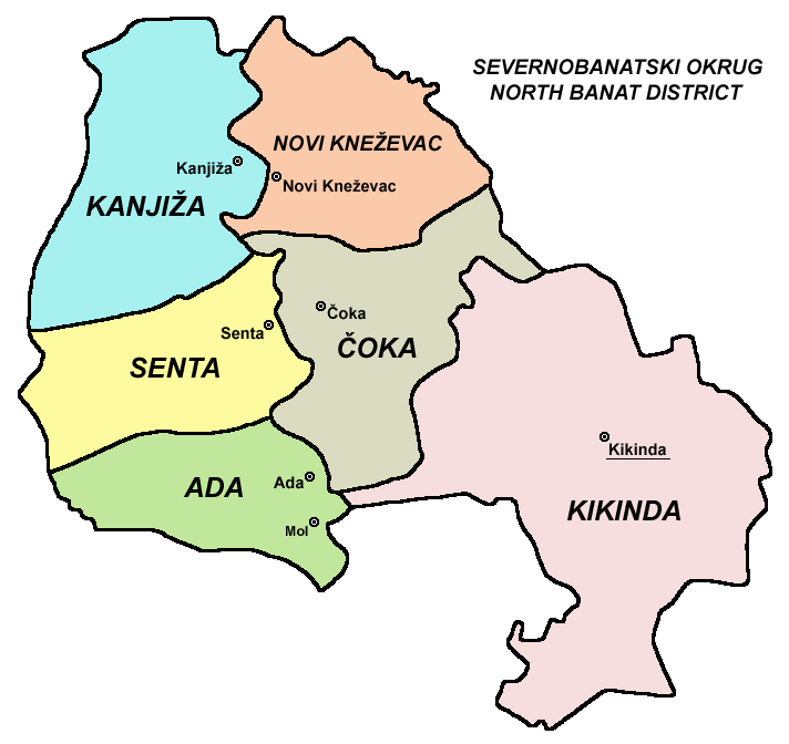
The North Banat District encompasses the territories of one city and five municipalities:
- Kikinda (city)
- Ada (Hungarian: Ada) (municipality)
- Čoka (Hungarian: Csóka) (municipality)
- Kanjiža (Hungarian: Magyarkanizsa) (municipality)
- Novi Kneževac (municipality)
- Senta (Hungarian: Zenta) (municipality)
An interesting fact is that the first three municipalities enlisted (Kanjiža, Senta, and Ada) are geographically, in fact, in the Bačka region, since the natural border between Banat and Bačka is the river Tisa.
Demographics
|1948|189050 |1953|189414 |1961|194150 |1971|191632 |1981|187179 |1991|179783 |2002|165881 |2011|147770 |2022|117896
Towns
There are two towns with over 10,000 inhabitants.
- Kikinda: 32,084
- Senta: 14,452
Ethnic structure
| Ethnicity | Population | Share |
|---|---|---|
| Serbs | 51,848 | 44% |
| Hungarians | 50,643 | 43% |
| Roma | 4,277 | 3.6% |
| Others | 2,877 | 2.4% |
| Undeclared/Unknown | 8,251 | 7% |
The municipalities with a Serb ethnic majority are Kikinda (75.8%) and Novi Kneževac (58%); the municipalities with a Hungarian ethnic majority are: Kanjiža (83.1%), Senta (75.7%), Ada (72.7%), while municipality with Hungarian relative ethnic majority is Čoka (44.8%). As for the local communities, 29 have a Hungarian ethnic majority, 19 have a Serb ethnic majority, and 2 are ethnically mixed, with a Hungarian relative ethnic majority.
References
Note: All official material made by the Government of Serbia is public by law. Information was taken from the official website.
References
- "2011 Census of Population, Households and Dwellings in the Republic of Serbia". Statistical Office of the Republic of Serbia.
- "Ethnicity - Data by municipalities and cities".
This article was imported from Wikipedia and is available under the Creative Commons Attribution-ShareAlike 4.0 License. Content has been adapted to SurfDoc format. Original contributors can be found on the article history page.
Ask Mako anything about North Banat District — get instant answers, deeper analysis, and related topics.
Research with MakoFree with your Surf account
Create a free account to save articles, ask Mako questions, and organize your research.
Sign up freeThis content may have been generated or modified by AI. CloudSurf Software LLC is not responsible for the accuracy, completeness, or reliability of AI-generated content. Always verify important information from primary sources.
Report