From Surf Wiki (app.surf) — the open knowledge base
Nile
Major river in northeastern Africa
Major river in northeastern Africa
| Field | Value |
|---|---|
| name | Nile River |
| mapframe | no |
| image | Beautiful nature along Nile River 01.jpg |
| image_caption | The Nile downstream from Murchison Falls |
| image_alt | A photograph of a large, rapidly-flowing river, with dense foliage on both banks, and a blue sky above |
| subdivision_type1 | Countries |
| subdivision_name1 | Burundi, DR Congo, Egypt, Eritrea, Ethiopia, Kenya, Rwanda, South Sudan, Sudan, Tanzania, Uganda |
| subdivision_type2 | Major cities |
| subdivision_name2 | Bahir Dar, Cairo, Khartoum, Jinja, Juba |
| length_km | 7088 |
| length_ref | |
| basin_size | 2927843 km2 |
| discharge1_location | Nile Delta into Mediterranean Sea |
| discharge1_avg | 150 m3/s |
| source1 | Rukarara River, Rwanda |
| source1_coordinates | |
| source1_elevation | 2539 m |
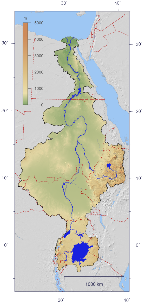
The Nile River is a major north-flowing river in northeastern Africa which flows into the Mediterranean Sea. At 7088 km long, it is the longest river in the world, although the volume of water it carries is much smaller than other major rivers such as the Amazon or Congo. Its drainage basin covers portions of eleven countries: the Democratic Republic of the Congo, Tanzania, Burundi, Rwanda, Uganda, Kenya, Ethiopia, Eritrea, South Sudan, Sudan, and Egypt. It plays an important economic role in the economy of these nations, and it is the primary water source for South Sudan, Sudan and Egypt.
The Nile has two major tributaries: the White Nile and the Blue Nile. The White Nile, being longer, is considered to be the headwaters, although the Blue Nile contributes 80% of the water and silt below the confluence of the two. The White Nile begins at Lake Victoria and flows through Uganda and South Sudan, while the Blue Nile begins at Lake Tana in Ethiopia and flows into Sudan from the southeast. The two rivers meet at the Sudanese capital of Khartoum. After Khartoum the river flows north, almost entirely through the Nubian Desert, to Cairo and its large delta, joining the Mediterranean Sea near Alexandria.
Egyptian civilization and Sudanese kingdoms have depended on the river and its annual flooding since ancient times. Most of the population and cities of Egypt lie along those parts of the Nile valley north of the Aswan Dam. Nearly all the cultural and historical sites of Ancient Egypt developed and are found along river banks. The Nile is, with the Rhône and Po, one of the three Mediterranean rivers with the largest water discharge.
Names and etymology
The English word Nile is derived from the from the Latin Nilus and the Ancient Greek Νεῖλος (Neilos), which probably originated from the Semitic term naḥal, meaning "river".
In the ancient Egyptian language, the Nile was called Ar or Aur, meaning 'black', probably in reference to the dark color of the Nile floodwaters as they carried sediment from upriver.
In the modern era, within the Nile Basin, the river goes by several names. In Egypt, its names use the Arabic word النيل (romanized as 'Nil') in forms such as Al-Nīl, Baḥr Al-Nīl or Nahr Al-Nīl.{{Multiref |. |.
Physical geography
The Nile River is a major river in northeastern Africa which flows into the Mediterranean Sea. Its drainage basin includes portions of eleven countries: the Democratic Republic of the Congo, Tanzania, Burundi, Rwanda, Uganda, Kenya, Ethiopia, Eritrea, South Sudan, Sudan, and Egypt. The basin covers a wide variety of climates, ecosystems, and topographies.
Sources
The source of the Nile is a tributary of the Rukarara River, in Nyungwe National Park, Rwanda, at , at an elevation of 2,539 meters.{{Multiref |. |.
The highest sources of the Nile (based on elevation) are on the slopes of the Rwenzori Mountains in Uganda. The legendary Mountains of the Moon, described by Ptolemy, have been associated with Rwenzori.{{Multiref |. |.
The southernmost source of the Nile is in Burundi at one of the heads of the Ruvyironza River, which feeds into the Kagera River. A monumuent was erected there in 1937 by Burkhart Waldecker near the town of Rutovu, close to Mount Kikizi.
Lake Victoria is sometimes informally described as the source of the Nile, partly because early European explorers claimed that the lake was the source; and partly because the lake's outflow river is the most upstream river called the "Nile" (rivers flowing into Lake Victoria, such as the Kagera River, do not have the word "Nile" in their names). Some have suggested that the true source of the Nile is the rain clouds that are often found above Lake Victoria, because they supply five times more water to the lake than the lake's inflow rivers.
The source of the Blue Nile tributary is near the town of Gish Abay, south of Lake Tana.
Regions of the Nile Basin
The Nile Basin can be divided into seven regions; five of these regions encompass the longest course of the Nile River. Proceeding in a downstream sequence, these five regions are: the African Great Lakes, the Mountain Nile, the White Nile, the main Nile, and the Nile Delta. Two additional regions encompass major tributaries: the Blue Nile and the Atbarah River.
African Great Lakes
The African Great Lakes region contains the source of the Nile river as well as several large lakes that are part of the Nile river system: Lake Victoria, Lake Albert, Lake George, and Lake Edward. The source of the Nile is the Rukarara River within Rwanda's Nyungwe National Park, and it leads to the Kagera River, which drains into Lake Victoria. Although it is a large lakethe second-largest freshwater lake in the world Lake Victoria is relatively shallow. The Nile river first assumes the name "Nile" where Lake Victoria empties on its north side: the course from there to Lake Albert is called the Victoria Nile. A pair of waterfalls Ripon Falls and Owen Falls were located where the Nile exits Lake Victoria, but have both been submerged by the construction of the Nalubaale dam. After Bujagali Falls and Bujagali Power Station, the Victoria Nile empties into Lake Kyoga. After exiting Lake Kyoga, the river is joined by the River Kafu tributary, then passes over Murchison Falls and flows into Lake Albert. Unlike Lake Victoria, Lake Albert is a deep lake surrounded by mountains. The river exits Lake Albert on its north shore, where it is called the Albert Nile; this stretch of the river is relatively flat and broad, and suitable for navigation by steamboats.
Mountain Nile
The second region of the Nile Basin, proceeding downstream, is the Mountain Nile ().{{Multiref |. |
White Nile
Continuing downstream, the third region of the Nile Basin is the White Nile region. About 140 km after Lake No, the swamps diminish near the city of Malakal, and the river enters a long, placid stretch extending to Khartoum, where it is joined by the Blue Nile near Khartoum, the capital of Sudan.
Main Nile

The fourth region of the Nile Basinthe main Nile{{efn|The segment of the Nile river between the Blue/White confluence and the Mediterranean is called the main Nile or the Sharan Nile.{{Multiref |. |.
Nile Delta
The fifth, and final, region encompassing the Nile river is the Nile Delta, a large triangular river delta (about 22,000 km) that extends from Cairo to the Mediterranean Sea. The river splits into two major distributaries (channels) within the delta: the Rosetta branch and the Damietta branch. The soil in the delta ranges from 15 to 22 meters thick, and the total volume (including the submerged portions) is about 150,000 km. The delta was created over several million years, built-up from soil carried down the river from the Ethiopian Highlands.{{Multiref |. |.
The final two regions of the Nile Basin are the Blue Nile basin and the Atbarah River basin, both discussed in the section on Tributaries.
Tributaries
The longest course of the Nile, which includes the White Nile tributary, has several other tributaries that feed into it.
Blue Nile
Main article: Blue Nile
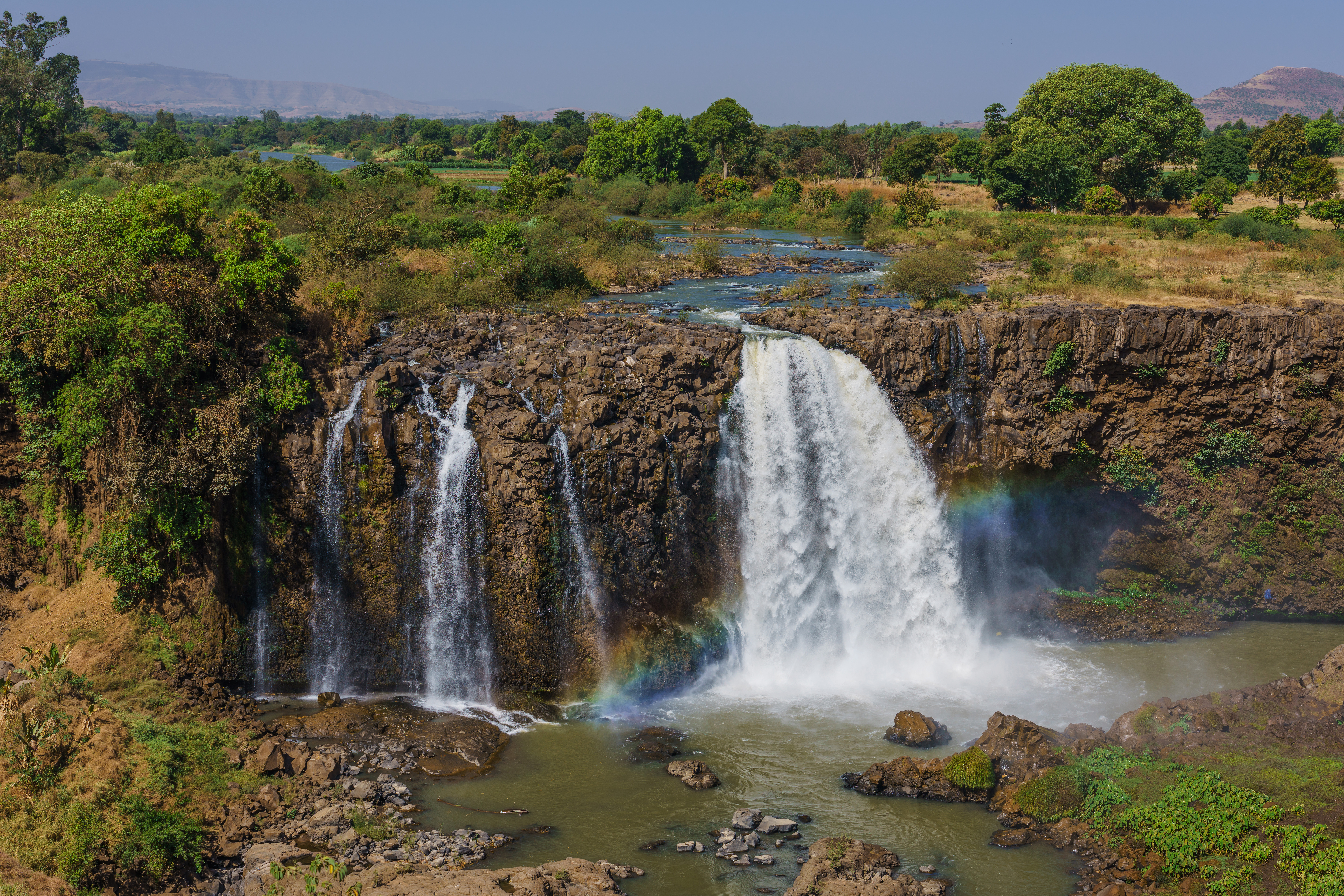
The Blue Nile springs from hills in Ethiopia where it originates as a stream named Abay near the town of Gish Abay: Gish in an Amharic word meaning 'source', and Abay is the name of the stream. Gish Abay flows into Lake Tana, a large, shallow lake, which has a single outflow where it adopts the 'Blue Nile' name. The Blue Nile travels south, then north passing through South Sudan into Sudan, where it joins with the White Nile at Khartoum to form the main Nile. Along its course, the Blue Nile generates electricity at several hydro power plants, including the Tisabay hydropower project at the Blue Nile Falls, the Grand Ethiopian Renaissance Dam near the border between Ethiopia and South Sudan, the Roseires Dam near town of Ad Damazin, and the Sennar Dam.{{Multiref |. Blue Nile Falls. |. Roseires Dam. |. Grand Ethiopian Renaissance Dam. |. Sennar Dam.
Atbarah River
Main article: Atbarah River
The Atbarah River is a tributary of the Nile which arises in northern Ethiopia, and joins the Nile about 320 km north of Khartoum. Its drainage basin covers over 204,000 square km. The Atbarah has a heavy flow during and following the monsoon season in Ethiopia (summer and fall), but can dry up in the winter and spring. Despite the intermittent nature of the river, it provides more than 10% of the total annual flow of the Nile.{{Multiref |. |. |. |. Tekezé Dam. |. Khashm el-Girba Dam. |. Upper Atbara and Setit Dam Complex.
Bahr el Ghazal and Sobat River
The Bahr al Ghazal and the Sobat River are two tributaries of the White Nile. The Bahr el Ghazal arrives from the west, joining the White Nile at Lake No. The drainage basin of the Bahr el Ghazal river is largeabout 860,000 square kmand receives a relatively large amount of rain, but its contribution to the Nile is insignificant. The basin includes Lake Kundi and Lake Keilak. The Bahr el Ghazal passes through the city of Wau, South Sudan: it is a permanent stream east of Wau, but a seasonal stream to the west.{{multiref |. |.
Another tributary, the Sobat River, joins the White Nile (after the Bahr el Ghazal confluence, before the Blue Nile) near the town of Malaka. Its basinwhich includes the Machar Marshescovers about 225,000 square km. The Sobat floods between July and December.
Hydrology
Flow and floods
Although the Nile is the longest river in the world, it is far from having the largest discharge. Its flowabout 84 cubic km per yearis small compared to other major rivers. The Nile's discharge is only 1% of the Amazon, 6% of the Congo, and 12% of the Yellow River.{{Multiref |. |.
The present flow regime of the Nile was established about 15,000 years ago, when the summer monsoon shifted and substantially increased rainfall in the area of Lake Victoria and Lake Albert. The flood levels of both the Blue Nile and White Nile have fluctuated over the past 15,000 years, with unusually high flood levels occurring every few thousand years.
The annual contributions to the main Nile from the three primary tributaries are: 54% from the Blue Nile, 32% from the White Nile (including contributions from the Bahr el Ghazal and Sobat tributaries), and 14% from the Atabarah. The White Nile passes through the Sudd swamps before it reaches the Blue Nile; about half the water flowing into the Sudd is lost to evaporation before it flows out. At the confluence of the Blue Nile and White Nile in Khartoum, the Blue Nile provides two thirds of the water.
About 80% to 85% of the Nile's water reaching Egypt originates in Ethiopia (the Blue Nile, Atbarah, and Sobat tributaries combined); the remaining 15% to 20% is from the Great Lakes region and western South Sudan (the Mountain Nile and Bahr el Ghazal tributaries).
The highlands of the White Nile and Blue Nile both experience seasonal rain, but the White Nile's flow into the main Nile is much more constant than the Blue Nile. This is due to the many lakes and wetlands on the White Nile, which moderate the cyclic effects of seasonal rainfall.
In contrast, the Blue Nile has tremendous variability in its flow: it floods between July and October, due to summer monsoon rains. The waters of the Blue Nile are so substantial during the summer and autumn, that the White Nile backs-up during this time at the confluence. During the summer floods, the contributions to the main Nile are about 70% from the Blue Nile, about 20% from the Atbarah, and about 10% from the White Nile. At the peak of the flood, the daily flow into Lake Nasser is about 0.71 km, about three times the annual daily average of 0.23 km per day.{{Multiref |. Summer flood: 25.1 billion ft per day, or 0.71 km per day. |. Annual mean measured at Dongola station: 83 km per year, or 0.23 km per day.
As the Blue Nile flow diminishes in the winter, the pent-up waters of the White Nile increase their flow past Khartoum. In April and May, the White Nile supplies about 80% of the main Nile's water. Thus, the areas downstream of Khartoum receive a steady (not to say constant) flow that made irrigation possible year-round.
Prior to the construction of dams on the Nile, the variability of flow in Egypt was significant: higher in the summer/fall; lower in the winter/spring. However, following the construction of the Aswan High Damwhich created a reservoir that can hold about two years of river flow the flow downstream from that dam is now more constant year-round.{{Multiref |. |. |. |.
Sediment transport
The Nile carries sediment downstream. The movement of sediment is classified as suspended sediment (particles suspended in the water) or bedload (sediment on the river bottom that rolls or tumbles downstream).
Ninety-six percent of the transported sediment carried by the Nile comes from the Atbarah and Blue Nile, both of which originate in Ethiopia, with fifty-nine percent of the water coming from the Blue Nile. The erosion and transportation of silt only occurs during the Ethiopian rainy season when rainfall is especially high in the Ethiopian Highlands; the rest of the year, the great rivers draining Ethiopia into the Nile have a weaker flow. In harsh and arid seasons and droughts, the Blue Nile dries out completely.
Sediment carried by the Nile, or its tributaries, into a reservoir has the potential to settle in the reservoir and reduce the storage capacity of the reservoir. Sediment accumulated behind the Sennar Dam, Roseires Dam (on the Blue Nile), and Khashm el Girba Dam (on the Atbarah) has significantly reduced the storage capacity of their reservoirs since they were built.
Annual sediment transport measured at several locations are listed below. These measurements conducted at various dates, ranging from 1997 to 2019. The bedload percentages are the ratio of bedload sediment to total (bedload and suspended) sediment. These data were collected before the construction of the Grand Ethiopian Renaissance Dam, which has a significant impact on sediment loads downstream of the dam.
- Gilgel Abay, Ethiopia : 7.6 million tonnes of suspended, and an additional 0.7% of bedload
- El Deim (at the border of Ethiopia and Sudan): 140 million tonnes
- Aswan, Egypt: 0.14 million tonnes of suspended, and an additional 28% of bedload
- Beni Sweif, Egypt: 0.5 million tonnes of suspended, and an additional 20% of bedload
- Qena, Egypt: 0.27 million tonnes of suspended, and an additional 27% of bedload
- Sohag, Egypt: 1.5 million tonnes of suspended, and an additional 13% of bedload
Water sources and sinks

Some regions in the Nile Basin contribute to the river's flow, and other regions take from the river. A region is a 'source' if the region is contributing water to the rivers passing through; conversely, a region is a 'sink' if the region is removing water from the rivers passing through. Identifying sources and sinks is important to scientists that study water movement (hydrology), and also to policy makers that negotiate water sharing issues.
The regions of the Nile basin that are water sources are the upstream areas including the Ethiopian Highlands and the African Great Lakes region. The water sink areas are generally found in the downstream regions, including South Sudan, Sudan, and Egypt.
The water balance methodology is employed to determine which regions are sources and which are sinks. Water balance is a hydrological principle that states that the water entering a region is balanced by the water leaving a region. The water balance of a region can be represented by the following equation:
:P = ET + \Delta S + D + Q
In this formula, the precipitation (P) received is equal to the sum of the water losses: evaporation and transpiration (ET), groundwater recharge (\Delta S), lake-filling (D), and net streamflow (Q). Evaluating this formula will indicate if a region is a source or a sink. Generally, a region is a source if the net streamflow is positive; conversely, a region is a sink if the net streamflow is negative.
Sources and sinks: countries
The following table summarizes water balance measurements for countries within the Nile basin. Portions of countries outside the Nile Basin are excluded from the values. The "Source or Sink" column shows one of these values:
- SourceThe country is a significant water source
- SinkThe country is a significant water sink
- NeutralThe country is not a significant source or sink The data includes the following:
- Per-basin data: land surface area, precipitation, evapotranspiration, surface runoff
- Per-station data: discharge -- Most of the per-basin data is presented as annual measurements (usually in km); but some data is also presented as an equivalent "depth" value (millimeters per year, covering the entire basin).
| Country | Source or | |||||||||||||
|---|---|---|---|---|---|---|---|---|---|---|---|---|---|---|
| Sink | Basin | |||||||||||||
| Area km | Precip km | |||||||||||||
| (depth) | Evap km | |||||||||||||
| (depth) | Water | |||||||||||||
| Bal. | ||||||||||||||
| km | Runoff km | |||||||||||||
| (depth) | Burundi | DR Congo | Egypt | Eritrea | Ethiopia | Kenya | Rwanda | South | ||||||
| Sudan | Sudan | Tanzania | Uganda | Total | ||||||||||
| (depths are means) | 2,927,843 | 2,048 | ||||||||||||
| (699 mm) | 2,056 | |||||||||||||
| (702 mm) | −8 | 324 | ||||||||||||
| (111 mm) | ||||||||||||||
| 13,240 | 14 | |||||||||||||
| (1,092 mm) | 13 | |||||||||||||
| (951 mm) | 2 | 3 | ||||||||||||
| (242mm) | ||||||||||||||
| 19,919 | 23 | |||||||||||||
| (1,167mm) | 23 | |||||||||||||
| (1,142mm) | 0 | 0 | ||||||||||||
| (21 mm) | ||||||||||||||
| 235,108 | 4 | |||||||||||||
| (18 mm) | 44 | |||||||||||||
| (185 mm) | −39 | 0 | ||||||||||||
| (0 mm) | ||||||||||||||
| 24,427 | 14 | |||||||||||||
| ( 572 mm) | 12 | |||||||||||||
| (507 mm) | 2 | 0 | ||||||||||||
| (16 mm) | ||||||||||||||
| 363,775 | 459 | |||||||||||||
| (1,262 mm) | 295 | |||||||||||||
| (812 mm) | 164 | 138 | ||||||||||||
| (380 mm) | ||||||||||||||
| 49,513 | 76 | |||||||||||||
| (1,532 mm) | 49 | |||||||||||||
| (987 mm) | 27 | 23 | ||||||||||||
| (465 mm) | ||||||||||||||
| 20,676 | 21 | |||||||||||||
| ( 993 mm) | 20 | |||||||||||||
| (966 mm) | 1 | 4 | ||||||||||||
| (180 mm) | ||||||||||||||
| 617,256 | 612 | |||||||||||||
| ( 991 mm) | 757 | |||||||||||||
| (1,227 mm) | −146 | 92 | ||||||||||||
| (150 mm) | ||||||||||||||
| 1,226,660 | 364 | |||||||||||||
| ( 297 mm) | 445 | |||||||||||||
| (363 mm) | −81 | 23 | ||||||||||||
| (19 mm) | ||||||||||||||
| 120,506 | 160 | |||||||||||||
| (1,327 mm) | 122 | |||||||||||||
| (1,014 mm) | 38 | 18 | ||||||||||||
| (150 mm) | ||||||||||||||
| 236,763 | 301 | |||||||||||||
| (1,271 mm) | 276 | |||||||||||||
| (1,165 mm) | 25 | 22 | ||||||||||||
| (91mm) |
Sources and sinks: tributaries
Another way of analyzing the water balance of the Nile river is to partition the basin geographically (ignoring the national boundaries). The following tables split the Nile basin into twelve smaller basins, and summarize the water balance data of each of the smaller basins. The data is based on measurements made at a dozen river measurement stations. The stations divide the Nile basin into smaller basins. These basins are each named after their downstream station. For example, the Murchison Falls station (2) is downstream of the Lake Victoria outlet station (1), so the basin between them is named the Murchison Falls basin.
The basin data in the table is for each individual basin; it is not cumulative. For example, the runoff of station 5 is the runoff for the basin between stations 4 and 5, and excludes runoffs from upstream basins (1,2,3). The measuring stations are listed in the following tables proceeding from upstream to downstream. The discharge "rate" data is an average of the entire year.
:{| class= "wikitable mw-collapsible mw-collapsed nowrap col8center defaultright sortable" style="font-style: default; font-size: 85%;" |+ White Nile tributary water balance (annual){{efn|name=TableLegend|Hydrology Table Legend:
- Precip - Precipitation (P)
- Evap- Evapotranspiration (ET)
- Water Bal - Precip-ET
- Discharge - River flow at measuring station (average of the entire year)
- *Source or Sink * - Is basin a significant source or sink of water? ! scope="col" width="10%" | Basin's downstream station ! scope="col" width="10%" | Source or Sink ! scope="col" width="10%" | Basin Area km ! scope="col" width="12%" | Precip km (depth) ! scope="col" width="12%" | Evap km (depth) ! scope="col" width="10%" | Water Bal. km ! scope="col" width="10%" | Runoff km (depth) ! scope="col" width="12%" | Discharge km (rate) |- ! 1 Lake Victoria outlet | || 264,259 || 353 (1,337 mm) || 279 (1,055 mm) || 74 || 57 (214 mm) || 37 (1,176 m/sec) |- ! 2 Murchison Falls | || 85,513 || 109 (1,276 mm) || 94 (1,105 mm) || 15 || 9 (102 mm) || 30 (946 m/sec) |- ! 3 Mongalla | || 131,691 || 159 (1,209 mm) || 158 (1,201 mm) || 1 || 5 (38 mm) || 33 (1,050 m/sec) |- ! 4 Malakal | || 925,160|| 798 (863 mm) || 957 (1,034 mm) || −159 || 150 (162 mm) || 30 (939 m/sec) |- ! 5 Khartoum | || 257,130 || 134 (520 mm) || 174 (676 mm) || -40 || 14 (53 mm) || 28 (897 m/sec) |}
:{| class= "wikitable mw-collapsible mw-collapsed nowrap col8center defaultright sortable" style="font-style: default; font-size: 85%;" |+ Blue Nile tributary water balance (annual) ! scope="col" width="10%" | Basin's downstream station ! scope="col" width="10%" | Source or Sink ! scope="col" width="10%" | Basin Area km ! scope="col" width="12%" | Precip km (depth) ! scope="col" width="12%" | Evap km (depth) ! scope="col" width="10%" | Water Bal. km ! scope="col" width="10%" | Runoff km (depth) ! scope="col" width="12%" | Discharge km (rate) |- ! 6 Roseires Dam | || 188,296|| 246 (1,309 mm) || 142 (752 mm) || 105 || 70 (372 mm) || 49 (1,548 m/sec) |- ! 7 Khartoum | || 118,651|| 96 (686 mm) || 72 (605 mm) || 10 || 9 (75 mm) || 48 (1,513 m/sec) |}
:{| class= "wikitable mw-collapsible mw-collapsed nowrap col8center defaultright sortable" style="font-style: default; font-size: 85%;" |+ Atbarah tributary water balance (annual) ! scope="col" width="10%" | Basin's downstream station ! scope="col" width="10%" | Source or Sink ! scope="col" width="10%" | Basin Area km ! scope="col" width="12%" | Precip km (depth) ! scope="col" width="12%" | Evap km (depth) ! scope="col" width="10%" | Water Bal. km ! scope="col" width="10%" | Runoff km (depth) ! scope="col" width="12%" | Discharge km (rate) |- ! 8 Khasm el Girba | || 100,318|| 95 (951 mm) || 66 (656 mm) || 30 || 10 (104 mm) || 10 (302 m/sec) |- ! 9 Mouth of Atbarah River | || 104,051 || 22 (215 mm) || 25 (242 mm) || −3 || 1 (6 mm) || 12 (373 m/sec) |}
:{| class= "wikitable mw-collapsible mw-collapsed nowrap col8center defaultright sortable" style="font-style: default; font-size: 85%;" |+ Main Nile water balance (annual) ! scope="col" width="10%" | Basin's downstream station ! scope="col" width="10%" | Source or Sink ! scope="col" width="10%" | Basin Area km ! scope="col" width="12%" | Precip km (depth) ! scope="col" width="12%" | Evap km (depth) ! scope="col" width="10%" | Water Bal. km ! scope="col" width="10%" | Runoff km (depth) ! scope="col" width="12%" | Discharge km (rate) |- ! 10 Dongola | || 390,180|| 34 (87 mm) || 45 (116 mm) || −11 || 0 (0 mm) || 83 (2,622 m/sec) |- ! 11 Aswan Dam | || 188,011||2 (12 mm) || 13 (70 mm) || −10 || 0 (0 mm) || 87 (2,757 m/sec) |- ! 12 Cairo/Delta | || 145,293||3 (18 mm) || 12 (85 mm) || −10 || 0 (0 mm) || 40 (1,251 m/sec) |}
Nilometers
.jpg)
Measurements of the Nile's flow has always been essential to help Egyptians manage their safety and irrigation. Simple gauges, called nilometers, have been used to measure the level of the Nile for thousands of years. An important nilometer has been in use on Roda Island since at least 622 AD; Egyptians kept records of maximum and minimum river levels from that gauge until 1921. Modern gauges to measure the river level began to be installed in the 1860s, and gauges that measured the river's currentwhich provide more accurate flow informationwere installed beginning in 1900.
Ecology
Plants
The Great Lakes region of the Nile Basin includes plants such as the water lily, papyrus, and water hyacinth. The water hyacinth in an invasive species, and has adversely impacted the populations of native species in Lake Kyoga.{{Multiref |. |. |. |.
Animals
Fish are abundant in the Nile Basin: the total number of species is estimated at over 800. In the river alone, 128 species are found, belonging to 27 families. The majority of species belong to the four families: Cichlidae (cichlids), Cyprinidae (carp), Mormyridae (elephantfish), and Mochokidae (catfish). A large number of Cichlid species are found in the African Great Lakes.{{Multiref |. |.
In addition to fish, animals that live in the water include hippos, crocodiles, and African buffalo. Other water dwellers include molluscs, crabs, and shrimp. Many animals live in the ecosystems along the river banks, including elephants, antelope, and giraffes. Snails found in Nile lakes carry parasitic flatformsknown as blood flukes which are responsible for the schistosomiasis disease that afflicts livestock and humans.
Birds that live on or near the Nile include herons, kingfishers, ospreys, and various kinds of storkssuch as shoebills.{{Multiref |. |. |. |. |.
Conservation
Several species of animals have become extinct in the Nile Basin due to human activity. The sacred ibis was important in the ancient Egyptian relgion, and millions of the ibis were ritually sacrificed, leading to the eventual extinction of the species throughout the Nile Basin. The bird remains common in central and southern Africa.
The Nile perch was native to several places in Africa, including the Congo, but was surreptitiously introduced to Lake Victoria in the 1950s to create a fishing stock. The Nile Perch caused the extinction of over 500 species of cichlids in Lake Victoria, which scientist Les Kaufman described as the first mass extinction of vertebrates that scientists have had the opportunity to observe.{{multiref | . |. |. |.
The satellite lakes of Lake Kyoga are potentially important for future conservation efforts, because they contain at least 60 species of haplochromines, and have not yet been invaded by the Nile Perch.
Pollution
Historically, the water of the Nile was noted for being drinkable, but in the late 20th century, it became less healthy in certain areas. Lake Tana is polluted with industrial pollution; Portions of the river near population centers (such as Khartoum and Cairo) are polluted with industrial pollutants and sewage; ships contribute pollutants to the waters; and industrial plants in Egypt dump waste into the river.
Sources of pollution in the Nile include agricultural, industrial, and household waste. There are 36 industries that discharge their pollution sources directly into the Nile, and 41 into irrigation canals. These types of industries are: chemical, electrical, engineering, fertilizers, food, metal, mining, oil and soap, pulp and paper, refractory, textile and wood. There are over 90 agricultural drains that discharge into the Nile that also include industrial wastewater.
River pollution is most pronounced between Aswan and the Mediterranean Sea. The pollution there comes from human activities, agricultural runoff, and industrial waste. The river delta contains Egypt's primary oil and gas production facilities, and the chemical industry in the delta is the single largest contributor of toxic waste to the Nile. Concentrations of pollutants increase as the river flows downstream, due to the cumulative effects of pollution sources.{{Multiref |. |.
In the late 20th century, Lake Victoria experienced increased eutrophication (accumulation of nutrients, usually from fertilizers) resulting in excessive plant growth, which depletes oxygen levels in the water. The eutrophication is due to human activities and has been associated with algal blooms and a rapid proliferation of water hyacinth, which have disrupted the ecosystem.
Climate and climate change
The climate of the Nile Basin is defined by a pronounced gradient: very dry in the north, becoming progressively wetter to the south. The basin can be divided into nine distinct rainfall regions: the northern regions (Egypt and Sudan) are very dry all year; the middle regions (including Ethiopia) have strong peaks of rainfall in the summer; and the southern regions (around Lake Victoria) have two rainfall peaksin spring and fall. The majority of the rainfall in the Nile Basin is associated with the summer monsoon.
The Nile Basin is experiencing climate changes related to the increasing prevalence of greenhouse gasses in the atmosphere. Projections for the 21st century include a 2 to 4°C increase. The Blue Nile basin in Ethiopia has been experiencing significant changes in temperature and precipitation since the 1970s. In a review published in 2024, scientists predicted that temperatures would continue to rise. Rainfall is fluctuating and impacting crop production, but future trends are uncertain.
Models of the future climate in the North Africa and Middle East region predict increasing dryness and drought, and increasing variability of precipitation. The Nile Delta is particularly vulnerable, and the combined action of sea level rise and lack of sediment replenishment (due to dams on the Nile) may cause one third of the Nile Delta to disappear within the next century.
Geological history
Eonile in the Cenozoic era
During the Cenozoic era, the water drainage in northeast Africa (roughly where modern Egypt is) went through three major phases. First, in the late Eocene, the Gilf system drained to the west, then north, and then into the Tethys Sea. This was followed, in the early Miocene, by the Qena system, in which several fragmentary rivers were formed near the Red Sea, generally flowing to the south. Finally, the Eonile river was formed in the late Miocene (8 to 6 MYA), which connected the Qena segments into a single river. The Eonile reversed the flow of the Qena, and flowed north into the Mediterranean Sea.
During the late-Miocene Messinian salinity crisis, when the Mediterranean Sea was a closed basin and evaporated to the point of being empty or nearly so, the Nile eroded its course into a deep valleycutting the channel down to several hundred meters below world ocean level at Aswan and 2400 m below Cairo.This created a very long and deep canyon which was filled with sediment after the Mediterranean was recreated.{{Multiref |. |. |.
Since 2 million years ago
After the Eonile was formed about 6 million years ago (MYA), it subsequently evolved through several phases before the modern Nile was formed:{{Multiref |. |.
- Paleo-Nile, formed about 1.7 MYA
- Proto-Nile, formed about 1.5 MYA
- Pre-Nile, formed about 700 KYA (KYA = thousand years ago)
- Neo-Nile, formed about 120 KYA
- Modern Nile, began to form about 30 KYA, when the African Great Lakes region tilted northward, and began draining into the Nile. Around 14 to 12 KYA, the lakes Tana, Albert, and Victoria started to flow southward approximately into the current course of the Nile.{{Multiref | |
Human history
Ancient Egyptian civilization
traversing the Nile near Aswan]]
The Nile was central to the entire ancient Egyptian civilization: it provided life through the crops it watered, and it caused death, when droughts caused crop failures and famine. The Nile encouraged the growth of science and government: irrigation, flood predictions and taxation all required new mathematical and administrative skills. Weather prediction and astronomy also developed as a consequence of the Egyptian's need to understand the river and its floods. The Nile led the Egyptians to build the world's first major dam the Sadd el-Kafara ('dam of the infidels')circa 2600 BC in an attempt to control flooding. Some peoples migrated from the Sahara and southerly African regions into the early Nile Valley.
Nile river provided irrigation and transportation that enabled the ancient Egyptians to establish flourishing and long-lived trade with neighbors. They cultivated and traded wheat, flax, papyrus and other crops, contributing to economic stability.
The ancient Egyptians were familiar with the course of the Nile upstream to the sixth cataract (present day Khartoum), but apparently were not familiar with the course of the White Nile (or its source) beyond that.{{Multiref |. |.
The ancient Egyptian calendar was based on the flood cycle of the Nile. The year was divided into three seasons, each consisting of four months of thirty days each. The seasons were Akhet (literally, 'innundation'), Peret ('growing'), and Shemu ('harvest'). Akhet was the time of the year when the Nile flooded, leaving a new layer of fertile soil behind; Peret was the growing season; and Shemu was the harvest season when there were no rains.{{Multiref |. |.
Search for the source of the Nile

Since the times of the ancient Greeks, Europeans have been intensely curious about the source of the Nile and the origin of its floods, yet concrete knowledge about the source of the Nile was not discovered until the late Middle Ages. Herodotus was a Greek historian who visited Egypt in 457 BC, and traveled up the Nile to Aswan. In the second century BC, the Greek scientist Eratosthenes drew a map of the Nile from the Mediterranean to Khartoum, and speculated that the source was a collection of lakes.{{Multiref |. |. |.
The source of the Blue Nile was established as a result of Portuguese interest in Ethiopia: the Jesuit missionary Pedro Páez visited the sourceGish Abayin early 17th century, and wrote História da Ethiópia describing his time in Ethiopia. His accounts were not published until 1905, but other authors (including Jerónimo Lobo, James Bruce, and Athanasius Kircher) gave various estimates of the date of Páez's visit to Gish Abayranging from 1613 to 1618.
The source of the White Nile proved to be more difficult to establish than that of the Blue NileLake Victoria was not definitively established as the major source of the White Nile until 250 years after Gish Abay was identified as the Blue Nile's source.
In 1857, John Hanning Speke and Richard Francis Burton started a search for the Nile's source by departing from Zanzibar on the east coast of Africarather than traveling upriver from Egyptand headed westward to the interior of Africa. They reached Lake Tanganyika and determined it was not the source. Speke returned to Africa in 1860 and traveled to Lake Victoria, which he concluded was the source. In 1864, Samuel Baker became the first European to follow the Nile upstream from the Mediterranean Sea to Lake Albert. In 1874, Henry Morton Stanley confirmed that Lake Victoria was connected to the Nile river by circumnavigating the lake and locating where the Nile flowed out of the lake: at Ripon Falls on the lake's northern shore.
Efforts to pinpoint the furthermost source of the White Nile began in early 20th century when Richard Kandt suggested that the source was a tributary of the Kagera River in the Nyungwe Forestthe Kagera feeds into Lake Victoria. The source location was refined in 1969 when a group of researchers from Waseda University identified a specific tributary of the Kagera. In 2006, a group of adventurers rediscovered this source, and placed a large marker on a nearby tree. In 2009, academics used satellite imagery to further refine the location of the source, placing it at a spring several km from the 1969/2006 source.
Dams and water politics
Pre-colonial era
The ancient Egyptians were proficient at canal-building, which they used to support surface irrigation technologies which simply diverted floodwaters into basins and floodplains. They did not successfully build dams or reservoirs.
Dams were not successfully built on the Nile until the 19th century, when cottonirrigated by the Nile waters became an important cash crop for Egypt. These early dams were built during the rule of Muhammad Ali (ruler of Egypt from 1805 to 1848). These first small dams were constructed in the Nile Delta and near Cairo, and acted to extend the growing season of crops. Ali also built canals such as the Mahmoudiyah Canal, started in 1818.
Colonial era
After the British began their colonial rule of Egypt in 1882, they started additional water projects to enhance the production of the cotton industry and support the rapidly growing Egyptian population.{{Multiref |. |. |. |. |.
In 1929, an agreement between Egypt and Sudan was formed.{{Multiref |. |. |. |. |.
Post-colonial era
Egypt and Sudan became completely independent from Britain in 1956. In 1959 Egypt and Sudan updated the 1929 water sharing agreement. The new agreement allocated the water be shared between Egypt and Sudan and at 55.5 and 18.5 billion cubic meters respectively.{{Multiref |. |.
The 1959 agreement included terms permitting Egypt and Sudan to build dams, which they did: Egypt built the Aswan High Dam (completed 1970); Sudan built the Khashm el-Girba Dam (1964), Roseires Dam (1966), Merowe Dam (2009), and Upper Atbara and Setit Dam Complex complex (2017).
In 1960, Egypt started building the Aswan High Dam (completed in 1970) which stores roughly two years flow of the Nile river.{{Multiref |. |. |.
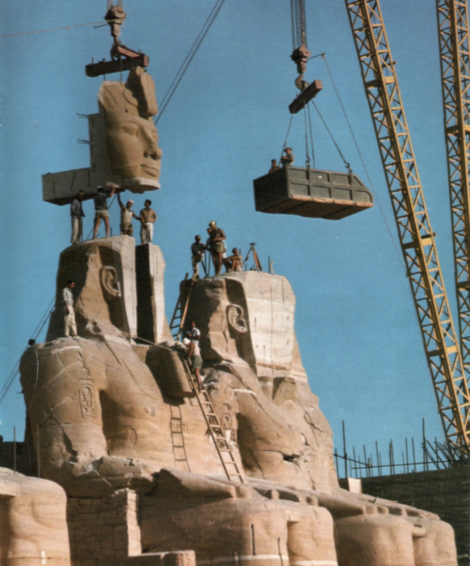
The Aswan High Dam flooded a large area of the Nile valley, and would have submerged several important historical monuments. An international campaign to save some monuments from becoming submerged by the new reservoir successfully saved some monuments, including the Abu Simbel temples. The Aswan High Dam also forced the relocation of many Nubians that lived in the valley innundated by the new reservoir. The Nubians were removed from their ancestral homelands, and many forced to immigrate to cities in Egypt and Sudan.
Late 20th century disagreements and negotiations
Throughout the 20th century, there was a marked imbalance in political power within the Nile Basin: Egypt and Sudan in the north wielded more power than other ten nations to the south. After Egypt and Sudan created the 1959 agreement, several of the upstream nations (including Kenya, Tanzania, Uganda, and Ethiopia) began to voice objections to the terms of the agreement, and argued that they were not bound by the agreement because they were not parties to it. The arguments of the upstream nations were that the dams built by Egypt and Sudan protected those two countries from drought, famine, and floods, yet upstream countries such as Ethiopia and were still subject to droughts and famine. For example, the Aswan High Dam generated about 10 billion kilowatt hours per year; and enabled Egyptian farmers to cultivate three harvests per year, compared to a single harvest before the dam. Egyptian leaders often stated that they were willing to employ military force to protect their rights under the 1959 agreement.{{Multiref |. |.
In the late 20th century, African nations participated in several efforts to establish water-sharing policiesincluding the Undugu Commission (active from 1983 to 1993) and TECCONILE (active 1993 to 1998) but were not successful in creating long-term agreements.
In 1999, nine of the ten Nile Basin countriesBurundi, Democratic Republic of the Congo, Egypt, Ethiopia, Kenya, Rwanda, Sudan, Tanzania and Ugandaestablished the Nile Basin Initiative to promote peaceful dialog regarding issues related to the Nile Basin.{{Multiref |. |.
Power shift to upstream nations

Since the colonial era, two downstream nationsEgypt and Sudanexerted control over the Nile's waters from a position of dominance; but at the start of the 21st century, power shifted to the upstream nations.{{Multiref |. |. |. In 2008, Ethiopia built the Tekezé Dam without seeking permission of Egypt or Sudan. In 2010, five upstream countriesUganda, Ethiopia, Rwanda, Tanzania, and Kenya{{efn|Kenya was not one of the initial signatories, but signed it soon after it was created. |. |. |.
In 2011, Ethiopia announced plans to build a large dam on the Blue Nile near the border with Sudan. The dam was later named the Grand Ethiopian Renaissance Dam (GERD). Ethiopia viewed the GERD as essential to the nation's future, because the electrical power generated by the dam would enable them to significantly increase their propsperity. Egypt was concerned that the dam will imperil the irrigation of their crops because Egypt already uses far more water than enters the country, and they are concerned that the dam would exacerbate that shortfall. Sudan was concerned about safety and water supply. After the dam was announced, Egyptian president Mohamed Morsi hinted that military strikes on Ethiopia were an option, and Sudan and Egypt conducted several joint military exercises.
Numerous negotiations and mediations between Ethiopia, Sudan, and Egypt were held while the dam and reservoir were constructed and filled. In 2015 the countries signed the "Declaration of Principles" in which they agreed to cooperate. In 2019, the United States hosted talks between the involved nations. In 2020, the African Union started facilitating talks. In 2020, Egypt asked the United Nations Security Council to intervene, but it declined to do so. In 2021 and 2022, the UAE hosted talks. Construction of the GERD dam completed in 2020, and in 2025 the reservoir was filled and most of the dam's generators were producing electricity.
Economy
Agriculture
The Nile delta is especially productive, and accounts for two thirds of Egypt's agricultural output.
Fishing
The entire Nile river and its associated lakes, is a fishery that supplies a major source of food for peoples that live in the basin. Some species, particularly, Nile Perch are exported to Europe. Fish farming is performed at some places in the basin. Overfishing has been encountered in several locations.
Power generation

Transportation
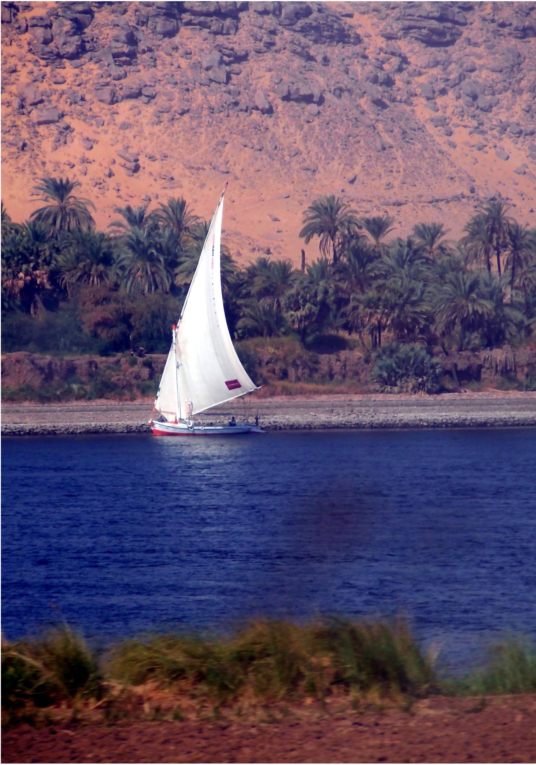
The Nile has long been used to transport goods along its length. Winter winds blow south, up river, so ships could sail up river using sails and down river using the flow of the river. While most Egyptians still live in the Nile valley, the 1970 completion of the Aswan Dam ended the summer floods and their renewal of the fertile soil, fundamentally changing farming practices. The Nile supports much of the population living along its banks, enabling Egyptians to live in otherwise inhospitable regions of the Sahara. The river's flow is disturbed at several points by the Cataracts of the Nile which form an obstacle to navigation by boats. The Sudd also forms a formidable navigation obstacle and impedes water flow, to the extent that Sudan had once attempted to build the Jonglei Canal to bypass the swamp.
Tourism
In culture
Art and literature

_(cropped).jpg)
A tune, Hymn to the Nile, was created and sung by the ancient Egyptian peoples about the flooding of the Nile River and all of the miracles it brought to Ancient Egyptian civilization.
Landscape artwork featuring the Nile rivereither directly or allegoricallyare called Nilotic landscapes. The term primarily designates artwork from ancient Greek or ancient Rome, though it is occasionally used to refer to scenes of hunting and fishing in Egyptian art. Nilotic landscapes are characterized by a river scene with rich and abundant plant and animal life, much of which is native to Egypt. Common iconographic elements include papyrus, palm trees, fish and water birds, and in some cases felines, monkeys, and/or crocodile. Imperial Roman scenes have a larger emphasis on fierce animals, usually including crocodiles and hippopotamus.{{Multiref | |
A notable representation of the Nile in art is the Personification of the River Nile, a colossal marble sculpture from 2nd century AD Romenow in the Vatican Museum. The Nile is represented as a reclining man holding sheaves of wheat in his hand. At his side are a sphinxrepresenting Egyptand sixteen children which allude to sixteen cubits (the ideal height of the annual flood). At the base are crocodiles, pygmies, and hippopotamus.{{Multiref |. |. |.
The Nile is seen in artworks that feature four major rivers of the world: Nile (Africa), Danube (Europe), Ganges (Asia), and Río de la Plata (Americas). Examples include the painting The Four Rivers of Paradise by Peter Paul Rubens (1615), and the fountain in Rome Fontana dei Quattro Fiumi designed by Gian Lorenzo Bernini (1651). In Bernini's fountain, the Nile is depicted as a man with his head coverd in a cloth, symbolizing the mystery of the unknown source of the Nile.
Shakespeare has the character Marc Antony describe the Nile floods in the play Antony and Cleopatra: "Thus do they, sir: they take the flow o’ the Nile By certain scales i’ the pyramid; they know, By the height, the lowness, or the mean, if dearth Or foison follow: the higher Nilus swells, The more it promises: as it ebbs, the seedsman Upon the slime and ooze scatters his grain, And shortly comes to harvest."
Myth and religion

The cosmology of the ancient Egyptians was cyclic in nature: rather than viewing life as having a start and end, it was viewed as a perpetual cycle. This cyclic life-view was rooted in nature that surrounded the Egyptians, the daily passage of the sun and the annual floods of the Nile.{{Multiref |. |. |. |. |. |. |.
In the ancient Egyptian religion, no single god personified the Nile in the same way that the god Ra personified the sun. Gods associated with the river included Hapy (god of the annual floods) and Khnum (god of the first cataract), who were jointly responsible for producing the annual Nile flood that fertilized the country's farmland.{{Multiref |. |. |.
Isis was a major diety in the Egyptian religion who was strongly associated with the Nile river. Cults based on Isis spread from Egypt into Europe in the second century BC. An example of the influence of the cult of Isis in Europe is the Nile mosaic of Palestrina, located in Rome and dated to first century BC: the 4 by 3 meter mosaic depicts a detailed Nilotic landscape.
In Greek mythology, Nilus is the god of the Nile river, one of thousands of river-god children of Titans Oceanus and his sister-wife Tethys. Nilus was father of the naiad Memphis, mythical founder of the city of Memphis.
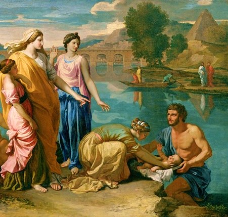
The Nile river is mentioned in the Bible dozens of times, including a story in the Book of Exodus about the infant Moses being placed in a basket in the river. Some authorities identify the river Gihonwhich is mentioned in the Book of Genesis as one of the four Rivers of Paradise as the Nile river. A story particularly important to the Coptic peoples of Egypt is found in the Book of Matthew: it recounts how Joseph and Mary fled to Egypt and lived near the Nile for several years, thus avoiding Herod.
References
Footnotes
Citations
Sources
Books
-
{{ cite book | editor-first=Henri | editor-last=Dumont | access-date= 1 December 2025 | chapter-url= https://archive.org/details/nileoriginenviro0000unse/page/749
-
{{cite book | last=Allen | author-link=James Peter Allen
-
{{cite book | author-link=Jan Assmann | orig-year=1984
-
{{cite Book | editor-first= Mohammad | editor-last = Badawi | access-date= 31 January 2026
-
{{cite Book | access-date= 1 January 2026
-
{{ cite book | editor-first=Henri | editor-last=Dumont | access-date= 1 December 2025 | chapter-url= https://archive.org/details/nileoriginenviro0000unse/page/307 | display-authors=etal
-
{{ cite book | editor-first=Henri | editor-last=Dumont | access-date= 1 December 2025 | chapter-url= https://archive.org/details/nileoriginenviro0000unse/page/1
-
{{ cite book | editor-first=Henri | editor-last=Dumont | access-date= 1 December 2025 | chapter-url= https://archive.org/details/nileoriginenviro0000unse/page/883 | display-authors=etal
-
{{ cite book | editor-first=Henri | editor-last=Dumont | access-date= 1 December 2025 | chapter-url= https://archive.org/details/nileoriginenviro0000unse/page/95
-
{{ cite book | editor-first=Henri | editor-last=Dumont | access-date= 1 December 2025 | chapter-url= https://archive.org/details/nileoriginenviro0000unse/page/125
-
{{ cite book | editor-first=Henri | editor-last=Dumont | access-date= 1 December 2025 | chapter-url= https://archive.org/details/nileoriginenviro0000unse/page/395
-
{{Cite book |last=Embabi |chapter-url=https://link.springer.com/book/10.1007/978-3-319-65661-8 |access-date=4 February 2020 |archive-date=4 February 2020 |archive-url=https://web.archive.org/web/20200204215026/https://link.springer.com/book/10.1007/978-3-319-65661-8 |url-status=live}}
-
{{cite book
-
{{ cite book | editor-first=Henri | editor-last=Dumont | access-date= 1 December 2025 | chapter-url= https://archive.org/details/nileoriginenviro0000unse/page/205
-
{{ cite book | editor-first=Henri | editor-last=Dumont | access-date= 1 December 2025 | chapter-url= https://archive.org/details/nileoriginenviro0000unse/page/705
-
{{ cite book | editor-first=Henri | editor-last=Dumont | access-date= 1 December 2025 | chapter-url= https://archive.org/details/nileoriginenviro0000unse/page/193
-
{{cite Book | access-date= 31 January 2026
-
{{ cite book | editor-first=Henri | editor-last=Dumont | access-date= 1 December 2025 | chapter-url= https://archive.org/details/nileoriginenviro0000unse/page/75
-
{{cite book |author-link=George Hart (Egyptologist) | access-date= 15 January 2026
-
{{cite book |author-link=Erik Hornung |orig-year= 1971 | access-date= 15 January 2026
-
{{ cite book | editor-first=Henri | editor-last=Dumont | access-date= 1 December 2025 | chapter-url= https://archive.org/details/nileoriginenviro0000unse/page/215
-
{{cite book | access-date= 15 January 2026
-
{{cite book |editor-first1=P.P. |editor-last1=Howell |editor-first2=J. J. |editor-last2=Alan |chapter-url=https://archive.org/details/isbn_9780521450409/page/321 |access-date=12 January 2026
-
{{cite book |editor-last1= Roach |editor-first1= Steven |editor-last2= Hudson |editor-first2= Derrick |access-date=15 January 2026
-
{{cite book |access-date=15 December 2025
-
{{cite book |author-link=Rushdi Said |access-date=15 December 2025
-
{{cite book |author-link=Simon Schama |access-date=15 December 2025
-
{{Cite book |access-date=7 January 2026
-
{{Cite book |access-date=7 January 2026
-
{{Cite book |access-date=7 January 2026
-
{{ cite book | editor-first=Henri | editor-last=Dumont | access-date= 1 December 2025 | chapter-url= https://archive.org/details/nileoriginenviro0000unse/page/334 | display-authors=etal
-
{{ cite book | editor-first=Henri | editor-last=Dumont | access-date= 1 December 2025 | chapter-url= https://archive.org/details/nileoriginenviro0000unse/page/37 | display-authors=etal
-
{{ cite book | editor-first=Henri | editor-last=Dumont | access-date= 1 December 2025 | chapter-url= https://archive.org/details/nileoriginenviro0000unse/page/23
-
{{cite book | author-link = Terje Tvedt | access-date= 10 December 2025
-
{{ cite book | editor-first=Henri | editor-last=Dumont | access-date= 1 December 2025 | chapter-url= https://archive.org/details/nileoriginenviro0000unse/page/585
-
{{cite book |access-date=15 January 2026
-
{{ cite book | editor-first=Henri | editor-last=Dumont | access-date= 1 December 2025 | chapter-url= https://archive.org/details/nileoriginenviro0000unse/page/163 | display-authors=etal
-
{{Cite book |url-access=registration
-
{{ cite book | editor-first=Henri | editor-last=Dumont | access-date= 1 December 2025 | chapter-url= https://archive.org/details/nileoriginenviro0000unse/page/61 | display-authors=etal
-
{{ cite book | editor-first=Henri | editor-last=Dumont | access-date= 1 December 2025 | chapter-url= https://archive.org/details/nileoriginenviro0000unse/page/647 | display-authors=etal
Journals and websites
-
{{Cite journal |display-authors=etal |article-number= e2022EF002987 |access-date=31 December 2025
-
{{Cite journal | display-authors=etal |doi-access=free
-
{{Cite news |access-date=20 January 2026
-
{{Cite journal |display-authors=etal |article-number= 102007 |access-date=31 December 2025
-
{{Cite web |access-date=20 November 2016
-
{{Cite web |display-authors=etal |access-date= 14 January 2026
-
{{Cite journal |display-authors=etal |article-number=7626 |access-date=31 December 2025
-
{{Cite encyclopedia |author-link1=Harold Edwin Hurst |display-authors=etal |access-date=11 December 2025
-
{{Cite journal
-
{{Cite journal |display-authors=etal |access-date=31 December 2025 |article-number=123968
-
{{Cite journal |display-authors=etal |access-date=23 December 2018 |archive-date=23 December 2018 |archive-url=https://web.archive.org/web/20181223211543/https://www.researchgate.net/publication/220473241_Pinpointing_the_sources_and_measuring_the_lengths_of_the_principal_rivers_of_the_world |url-status=live
-
{{Cite journal |access-date=31 December 2025
-
{{Cite encyclopedia |display-authors=etal |access-date=31 December 2025
-
{{Cite journal
-
{{Cite journal
-
{{Cite journal |display-authors=etal |access-date=23 December 2025
-
{{Cite journal |display-authors=etal |access-date=31 December 2025
-
{{Cite web |author-link= Sundeep Waslekar |access-date= 20 January 2026
-
{{Cite journal |display-authors=etal |article-number = e25530 |doi-access= free
Unknown author
-
{{Cite encyclopedia |access-date=7 January 2026
-
{{Cite web |access-date= 14 January 2026
-
{{Cite web |access-date=31 December 2025
-
{{Cite web |access-date= 14 January 2026
-
{{cite web |access-date=20 January 2026
-
{{Cite book |access-date=11 December 2025
References
- The river's outflow from that lake occurs at {{coord. 12. 02. 09. N. 37. 15. 53. E. type:waterbody_region:ET
- "Late Pleistocene and Holocene environmental and climatic change from Lake Tana, source of the Blue Nile".
- (26 April 2013). "Two Niles Meet: Image of the Day".
- {{harvnb. Senay. 2014
- "General history of Africa, IX: General history of Africa revisited".
- Burton, R. F.. (14 November 1864). "Lake Tanganyika, Ptolemy's Western Lake-Reservoir of the Nile". Blackwell Publishing.
- Hassan, Fekri A.. (28 November 2007). "The Aswan Dam and the International Rescue Nubia Campaign". The African Archaeological Review.
- link. (5 September 2015 . October 1933. ''[[Popular Science]]'' (short article on top-right of page with map).)
- (1959). "Planning for the ultimate hydraulic development of the Nile Valley". Proceedings of the Institution of Civil Engineers.
- Barnett, M.P.. (1957). "Comment on the Nile Valley Calculations". Journal of the Royal Statistical Society, Series B.
- D.F. Manzer and M.P. Barnett, ''Analysis by Simulation: Programming Techniques for a High-Speed Digital Computer'', in Arthur Maas ''et al.'', ''Design of Water Resource Systems'', pp. 324–390, [[Harvard University Press]], Cambridge, Massachusetts, 1962.
- Hyginus]], ''Fabulae'' [https://topostext.org/work/206#0.2 Preface]
This article was imported from Wikipedia and is available under the Creative Commons Attribution-ShareAlike 4.0 License. Content has been adapted to SurfDoc format. Original contributors can be found on the article history page.
Ask Mako anything about Nile — get instant answers, deeper analysis, and related topics.
Research with MakoFree with your Surf account
Create a free account to save articles, ask Mako questions, and organize your research.
Sign up freeThis content may have been generated or modified by AI. CloudSurf Software LLC is not responsible for the accuracy, completeness, or reliability of AI-generated content. Always verify important information from primary sources.
Report