From Surf Wiki (app.surf) — the open knowledge base
Niagara River
River in New York, United States and Ontario, Canada

River in New York, United States and Ontario, Canada
| Field | Value |
|---|---|
| name | Niagara River |
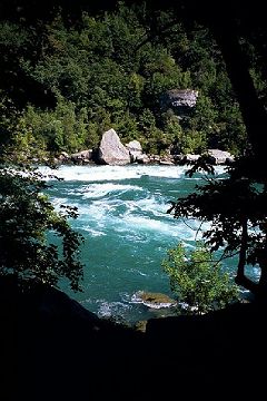
| image | Whirlpool Bridge (2936545446).jpg |
| image_caption | The Niagara River at Niagara Gorge in May 2008 |
| pushpin_map | North America#Canada Southern Ontario#USA New York |
| subdivision_type1 | Countries |
| subdivision_name1 | |
| subdivision_type2 | Province / State |
| subdivision_name2 | |
| length | 58 km |
| discharge1_avg | 5,796 m3/s |
| source1 | Lake Erie |
| source1_coordinates | |
| source1_elevation | 173.43 m |
| mouth | Lake Ontario |
| mouth_coordinates | |
| mouth_elevation | 74.1 m |
| progression | |
| basin_size | 684000 km2 |
| tributaries_left | Welland River |
| tributaries_right | Tonawanda Creek |
| extra | {{Designation list |
| embed | yes |
| designation1 | Ramsar |
| designation1_offname | Niagara River Corridor |
| designation1_date | October 3, 2019 |
| designation1_number | 2402}} |
WFILL\WFILL~Lake Ontario
uSTRWhirlpool Rapids
CWSTR!
uSTR
uSTR
uWWSEL!lCSTR~Niagara Escarpment
CWSTR!RP4oq~ / Queenston-Lewiston Bridge
uexRESVGr\CWSTR!WABZgr\Devil's Hole Rapids
CWSTR!Sir Adam Beck Hydroelectric Generating Stations
CWSTR!~WABZgl\uexRESVGlRobert Moses Niagara Power Plant
CWSTR~lWHST~Niagara Whirlpool
CWSTR~uhSTRaeq~Whirlpool Rapids Bridge
CWSTR!exhSTRaeq~Michigan Central Railway Bridge
CWSTR~Niagara Gorge
CWSTR!Horseshoe Falls / American Falls
WASSER2\WASSER3~RP4oq~ / Rainbow Bridge
WASSER+1\WASSER+4
WFALLg\WFALLg~Goat Island (New York)
uxWEIRf~International Control Dam
uCONTfaq\uexFABZgr+r!~uSTR+r\~~ Welland River
uSTR+l\uABZlr\uextABZq+lr!~uSTR+r\uextCONTfq~~ Intakes
uSPLae\uSKRZ-G4u~~ / North Grand Island Bridge
uSTR\uexKRWl!~uSPLae\uexCONTgeq~~Cayuga Creek
uSTR\uSTR~~Grand Island, NY
uSTR\uSPLae!~uKRWl\uCONTfq~~Tonawanda Creek / Erie Canal
uSTR\uSKRZ-G4u~~ / South Grand Island Bridge
uSTRl\uABZ+lr\uSTRr
uSPLae~~Strawberry Island
uexSTR!~uKRWl\uKRW+rBlack Rock Canal
uexSTR\uLock3Black Rock Lock
uexSTR!~hSTRaeq\umKRZuswInternational Railway Bridge
\uexSTR\ueABZgl\uexCONTgeqScajaquada Creek
uexSTR\uSTRUnity Island
uexSKRZ-G2hl\uSKRZ-G2hr / Peace Bridge
WDOCKSa-R\WDOCKSa-L~~Lake Erie
-endCollapsible-
| map-title =
The Niagara River ( ) flows north from Lake Erie to Lake Ontario, forming part of the border between Ontario, Canada, to the west, and New York, United States, to the east. The origin of the river's name is debated. Iroquoian scholar Bruce Trigger suggests it is derived from a branch of the local Neutral Confederacy, referred to as the Niagagarega people on several late-17th-century French maps. George R. Stewart posits that it comes from an Iroquois town named Ongniaahra, meaning "point of land cut in two."
The river, occasionally described as a strait, is approximately 58 km long and includes the Niagara Falls. Over the past 12,000 years, the falls have moved roughly 11 km upstream from the leading edge of the Niagara Escarpment, creating a gorge below the falls. Today, the diversion of the river for electricity generation has significantly slowed the rate of erosion. The total elevation drop along the river is 99 m. The Niagara Gorge, downstream from the falls, includes the Niagara Whirlpool and additional rapids.
Power plants on the river include the Sir Adam Beck Hydroelectric Generating Stations (built in 1922 and 1954) on the Canadian side, and the Robert Moses Niagara Power Plant (built in 1961) on the American side, collectively generating 4.4 gigawatts of electricity. The International Control Dam, constructed in 1954, regulates river flow. Ships on the Great Lakes use the Welland Canal, part of the St. Lawrence Seaway, on the Canadian side of the river, to bypass Niagara Falls.
The Niagara River features two large islands and several smaller ones. Grand Island and Navy Island, the two largest, are on the American and Canadian sides, respectively. Goat Island and the small Luna Island divide Niagara Falls into three sections: Horseshoe Falls, Bridal Veil Falls, and American Falls. Unity Island lies further upstream, adjacent to the city of Buffalo.
The Niagara River and its tributaries, Tonawanda Creek and the Welland River, formed part of the final section of the Erie Canal and Welland Canal. After leaving Lockport, the Erie Canal heads southwest into Tonawanda Creek. Upon entering the Niagara River, watercraft proceed south to the final lock, where a short canal section allows boats to bypass turbulent shoal water and enter Lake Erie. The Welland Canals used the Welland River to connect to the Niagara River south of the falls, enabling water traffic to safely re-enter the river and continue to Lake Erie.
History
.jpg)
The Niagara River and Falls have been known outside of North America since the late 17th century, when Father Louis Hennepin, a French explorer, first witnessed them. He wrote about his travels in A New Discovery of a Vast Country in America (1698).
The Niagara River was the site of the earliest recorded railway in America. It was an inclined wooden tramway built by John Montresor (1736–1799), a British military engineer, in 1764. Called "The Cradles" and "The Old Lewiston Incline", it featured loaded carts pulled up wooden rails by rope. It facilitated the movement of goods over the Niagara Escarpment in present-day Lewiston, New York.
In 1781, the Niagara Purchase was signed, involving a 6.5 km strip of land bordering the west bank of the Niagara River, connecting Lake Erie and Lake Ontario.
Several battles occurred along the Niagara River, which was historically defended by Fort George (Canadian side) and Fort Niagara (American side) at the mouth of the river and Fort Erie (Canadian side) at the head of the river. These forts were important during the Seven Years' War (known as the French and Indian War in the United States) and the American Revolutionary War. The Battle of Queenston Heights took place near the river in the War of 1812.
The river was an important route to liberation before the American Civil War, as many African Americans escaping slavery on the Underground Railroad crossed it to find freedom in Canada. The Freedom Crossing Monument stands on the bank of the river in Lewiston to commemorate the courage of the escaping slaves and the local volunteers who helped them secretly cross the river.
In the 1880s, the Niagara River became the first waterway in the world harnessed for large-scale generation of hydroelectricity.
On the Canadian side of the river the provincial agency Niagara Parks Commission maintains all of the shoreline property, including Fort Erie, except the sites of Fort George (a National Historic Site maintained federally by Parks Canada), as a public greenspace and environmental heritage.
On the American side, the New York State Office of Parks, Recreation and Historic Preservation maintains several state parks adjacent to Niagara Falls and the Niagara River.
Today, the river is the namesake of Niagara Herald Extraordinary at the Canadian Heraldic Authority.
Cities and settlements

Cities and towns along the Niagara River include:
| Name | Country |
|---|---|
| Buffalo | United States |
| Chippawa | Canada |
| Fort Erie | Canada |
| Lewiston | United States |
| Grand Island | United States |
| Niagara Falls | United States |
| Niagara Falls | Canada |
| Niagara-on-the-Lake | Canada |
| North Tonawanda | United States |
| Porter | United States |
| Queenston | Canada |
| Tonawanda (City) | United States |
| Tonawanda (Town) | United States |
| Wheatfield | United States |
| Youngstown | United States |
Pollution
The Niagara River is listed as a Great Lakes Areas of Concern in The Great Lakes Water Quality Agreement between the United States and Canada.
Crossings
Main article: List of crossings of the Niagara River
The Niagara River has a long history of both road and rail bridges spanning the river, both upstream and downstream of the Falls. This history includes numerous bridges that have fallen victim to the harsh conditions of the Niagara Gorge, such as landslides and icepacks.
Parks
The following parks are located along the Niagara River:
| Name | Country |
|---|---|
| Beaver Island State Park | United States |
| Bowen Road Park | Canada |
| Browns Point Park | Canada |
| Buckhorn Island State Park | United States |
| De Veaux Woods State Park | United States |
| Dufferin Islands Natural Area | Canada |
| Earl W. Brydges Artpark State Park | United States |
| Falkner Park | United States |
| Fisherman's Park | United States |
| Floral Clock Park | Canada |
| Fort George National Historic Site | Canada |
| Fort Niagara State Park | United States |
| Freedom Park | United States |
| Gratwick Riverside Park | United States |
| Griffon Park | United States |
| Jayne Park | United States |
| Joseph Davis State Park | United States |
| King's Bridge Park | Canada |
| MacFarland Park | Canada |
| Niagara Falls State Park | United States |
| Niagara Glen Nature Reserve | Canada |
| Niagara Parks Botanical Gardens | Canada |
| Niawanda Park | United States |
| Nike Base Park | United States |
| Queen's Parade Park & Memorial Park | Canada |
| Queenston Heights | Canada |
| Riverside Park | United States |
| Strawberry Island State Park | United States |
| Sugar Bowl Park | Canada |
| Veterans Memorial Park | United States |
| Queen Victoria Park | Canada |
| Whirlpool State Park | United States |
A Niagara River Greenway Plan is in progress in the United States.
Hydrologic features
| Feature | Location | Country | Notes | Photo | ||
|---|---|---|---|---|---|---|
| Source of Niagara River | Canada | |||||
| United States | The Niagara River originates at the north-east end of Lake Erie, and flows north to its mouth at Lake Ontario. | [[File:Peace Bridge.jpg | 100px]] | |||
| Black Rock Canal | United States | Black Rock Canal flows within and parallel to the east shore of the Niagara river near Buffalo, New York, and was built to extend the navigation period in the Niagara River through a greater part of the winter. The canal begins at Buffalo Harbor, on the north-east shore of Lake Erie, then flows north, ending at the Black Rock Lock near the north tip of Unity Island. The canal is buffered from the Niagara River by Bird Island Pier at its south end, and Unity Island at its north end. | [[File:Black Rock Canal Niagara.jpg | 100px]] | ||
| Gould Ditch | Canada | Historic tributary. Once served as a drainage ditch for Gould National Battery plant. | ||||
| Scajaquada Creek | United States | Tributary. | [[File:Scajaquada Creek within Forest Lawn Cemetery.jpg | 100px]] | ||
| Frenchman's Creek | Canada | Tributary. | ||||
| Chippawa Channel | Canada | |||||
| United States | The north-flowing Niagara River bifurcates at the south tip of Grand Island (both sections rejoin at the north tip). "Chippawa Channel" is the river passage on the west side of Grand Island. | |||||
| Miller Creek | Canada | Tributary. | ||||
| Tonawanda Channel | United States | When the Niagara River bifurcates at Grand Island, the east passage—from the south tip of Grand Island, to a point just north of Tonawanda, New York—is the "Tonawanda Channel". | ||||
| Baker Creek | Canada | Tributary. | ||||
| Black Creek | Canada | Tributary. | ||||
| Boyer's Creek | Canada | Tributary. | ||||
| Two Mile Creek | United States | Tributary. | ||||
| Little River (at Tonawanda Island) | United States | Flows between Tonawanda Island and the New York mainland, within the Tonawanda Channel. | ||||
| Tonawanda Creek | United States | Tributary. | [[File:Tonawanda mill dam 8928.jpg | 100px]] | ||
| Spicer Creek | United States | Tributary on Grand Island, New York. | ||||
| Big Sixmile Creek | United States | Tributary on Grand Island, New York. | ||||
| Little Sixmile Creek | United States | Tributary on Grand Island, New York. | ||||
| Niagara River Channel | United States | When the Niagara River bifurcates at Grand Island, the east passage—from a point just north of Tonawanda, New York, to the north tip of Grand Island—is the "Niagara River Channel". | [[File:Niagara River.jpg | 100px]] | ||
| Gun Creek | United States | Tributary on Grand Island, New York. | ||||
| Usshers Creek | Canada | Tributary. | ||||
| Burnt Ship Creek | United States | Tributary on Grand Island, New York. | ||||
| Woods Creek | United States | Tributary on Grand Island, New York. | [[File:Woods Creek - Grand Island, New York.jpg | 100px]] | ||
| Welland River | Canada | Historic tributary. Became a man-made distributary—from the Niagara River to a point 5 km west—in order to supply water to an intake channel for Sir Adam Beck Hydroelectric Power Stations. | ||||
| Underwater intake tunnel to Sir Adam Beck Hydroelectric Power Stations | Canada | [[File:Niagara-Tunnel-Project.gif | 100px]] | |||
| Little River (at Cayuga Island) | United States | Flows between Cayuga Island and the New York mainland, within the Niagara River Channel. | ||||
| Cayuga Creek | United States | Tributary. | ||||
| Underwater intake for tunnel to Niagara Power Project | United States | [[File:Upriver from Niagara Falls.jpg | 100px]] | |||
| Horseshoe Falls | Canada | Located between the Canadian mainland and Goat Island, New York, the Horseshoe Falls is the largest, and most south-western of three parallel waterfalls over which the Niagara River flows. There is dispute as to whether the Horseshoe Falls lies entirely within Canada (see Niagara Falls#History). | [[File:Horseshoe Falls 2006.jpg | 100px]] | ||
| Gill Creek | United States | Tributary. | ||||
| Goat Island Channel | United States | The Niagara River bifurcates at the south-east tip of Goat Island. "Goat Island Channel" is the north-east passage around the island. | [[File:Green Island & Goat Island pedestrian bridge 2008.jpg | 100px]] | ||
| Bridal Veil Falls | United States | Located between Goat Island and Luna Island, Bridal Veil Falls is the smallest (and middle) of the three parallel waterfalls over which the Niagara River flows. It is entirely within the US. | [[File:Bridal Veil Falls below.png | 100px]] | ||
| American Falls | United States | Located between Luna Island and the New York mainland, the American Falls is the most northern and second largest of three parallel waterfalls over which the Niagara River flows. It is located entirely within the US. | [[File:DSCN4390 americanfalls e.jpg | 100px]] | ||
| Muddy Run Falls | Canada | Historic tributary which entered the Niagara River as a waterfall from the top of the Niagara Gorge. Development above Muddy Run Falls destroyed its water supply. | ||||
| Whirlpool Rapids | Canada | |||||
| United States | [[File:Whirlpool Rapids Bridge 2.jpg | 100px]] | ||||
| Colt's Creek Falls | Canada | Tributary which enters the Niagara River as a waterfall from the top of the Niagara Gorge. The volume was greatly diminished following construction of the canal to Sir Adam Beck Hydroelectric Power Stations. | ||||
| Niagara Whirlpool | Canada | |||||
| United States | The Niagara Whirlpool is a natural whirlpool along the Niagara River located along the Canada–US border between New York and Ontario. The whirlpool is located in the Niagara Gorge, downstream from Niagara Falls. The whirlpool's greatest depth is 125 feet (38 m). | [[File:Niagara Whirlpool Spanish Aero Car.jpg | 100px]] | |||
| Harvie Falls | Canada | Tributary which enters the Niagara River as a waterfall from the top of the Niagara Gorge. The volume was greatly diminished following construction of the canal to Sir Adam Beck Hydroelectric Power Stations. | ||||
| Devil's Hole Rapids | Canada | |||||
| United States | [[File:Whirlpool Jet Boat Tours in Devil's Hole Rapids in Niagara River Gorge.jpg | 100px]] | ||||
| Bloody Run Falls | United States | Tributary which enters the Niagara River as a waterfall from the top of the Niagara Gorge. The volume was greatly diminished following construction of Robert Moses State Parkway and other streets above the falls. | [[File:Log Cabin, Bloody Run, Niagara, N.Y, from Robert N. Dennis collection of stereoscopic views.jpg | Log Cabin, Bloody Run, Niagara, N.Y, from Robert N. Dennis collection of stereoscopic views | 100px]] | |
| Niagara Power Project | United States | [[File:Robert moses secondary efflorescence 1.jpg | 100px]] | |||
| Sir Adam Beck Hydroelectric Power Stations | Canada | [[File:Adam Beck Complex.jpg | 100px]] | |||
| Smeaton Falls | Canada | Tributary which enters the Niagara River as a waterfall from the top of the Niagara Gorge. The volume was greatly diminished following the construction of Sir Adam Beck Hydroelectric Power Stations. | [[File:Smeaton Falls.jpg | 100px]] | ||
| Spring Cave Cascade | United States | Historic tributary which entered the Niagara River as a cascade from caves in the wall of the Niagara Gorge. Its source was destroyed following construction of the Niagara Power Project. | ||||
| Fish Creek Falls | United States | Tributary which enters the Niagara River as a waterfall from the top of the Niagara Gorge. The volume was greatly diminished following the construction of the Niagara Power Project. | ||||
| Locust Grove Falls | Canada | Tributary which enters the Niagara River as a waterfall from the top of the Niagara Gorge. The volume was greatly diminished following the construction of Sir Adam Beck Hydroelectric Power Stations. | [[File:Locust Grove Falls.jpg | 100px]] | ||
| Mouth of Niagara River | Canada | |||||
| United States | [[File:Niagara river mouth.JPG | 100px]] |
Islands
Several islands are located on the upper river upriver from the falls:
| Name | Location | Country | Status | Notes | |||||||
|---|---|---|---|---|---|---|---|---|---|---|---|
| Bird Island | Buffalo | nowrap | United States | Filled in | Connected to Unity Island in 1822 as part of improvements to Black Rock harbor. | ||||||
| Brig Island | Niagara Falls | United States | Park | Part of Niagara Falls State Park. | |||||||
| Brother Island | Niagara Falls | nowrap | United States | Park | Located near Niagara Falls and the Three Sisters Islands; part of Niagara Falls State Park. | ||||||
| Buckhorn Island | Grand Island | nowrap | United States | Park | Located on the north end of Grand Island. A state park. | ||||||
| Cayuga Island | Niagara Falls | United States | Residential | Located at the mouth of Cayuga Creek; a residential neighborhood of the city. | |||||||
| Cedar Island | Niagara Falls | Canada | Filled in | Filled in by the creation of the Rankine Generating Station by Canadian Niagara Power Company in 1905. | |||||||
| Conners Island | Niagara Falls | United States | Filled in | Also known in some sources as "Coroner Island". Filled in sometime in the 1950s or early '60s. Currently the site of the Niagara Power Station Intake. | |||||||
| Deer Island | Niagara Falls | United States | |||||||||
| Dufferin Islands | Niagara Falls | Canada | Park | Man-made islands. Parkland. | |||||||
| Goat Island | Niagara Falls | United States | Park | Located at the brink of the American Falls, named by John Stedman in the 1770s; briefly renamed to Iris Island by General Augustus Porter, a United States Commissioner (after the Greek Goddess of the Rainbow). Now part of Niagara Falls State Park. | |||||||
| Goose Island | City of Tonawanda | United States | Man-made/filled in | Was located at the confluence of Tonawanda Creek and the Tonawanda Channel of the Niagara River. Existed from 1825, when the Erie Canal was constructed (thereby cutting Goose Island off from the mainland) until the 1940s, when this portion of the canal was filled in. | |||||||
| Grand Island | United States | Developed | The largest island on the river; includes several parks, but is mostly residential and industrial; originally called Ga-We-Not (Great Island) by the Seneca. | ||||||||
| Grass Island | Niagara Falls | United States | Filled in | Filled in during the 1960s to create the Robert Moses Parkway at Point Day. | |||||||
| Green Island | Niagara Falls | United States | Park | Originally called Bath Island, it was renamed in the early 1900s for Niagara Reservation Commissioner Andrew H. Green. Part of Niagara Falls State Park. | |||||||
| Gull Island | Niagara Falls | Canada | Park | Located near the wreck of the Old Scow in Canadian waters. | |||||||
| Hogg Island | Niagara Falls | Canada | Filled in | Filled in by the creation of the Chippawa Queenston Power Canal in 1917 and finally by the Sir Adam Beck Dam #2 in 1950 by the Hydro Electric Power Commission of Ontario. | |||||||
| Little Beaver Island | Grand Island | nowrap | United States | Park | Located off the south end of Grand Island; part of Beaver Island State Park. | ||||||
| Luna Island | nowrap | Niagara Falls | United States | Park | Located next to Goat Island; originally called Prospect Island. Part of Niagara Falls State Park. | ||||||
| Motor Island | Grand Island | United States | Park | Also known as Pirates' Island (the name of a private club once located there) and Frog Island (not to be confused with the former Frog Island listed below). A New York State Wildlife Management Area. | |||||||
| Navy Island | Niagara Falls | Canada | Park | Designated as a National Historic Park. | |||||||
| Rattlesnake Island | Town of Tonawanda | United States | Filled in | Was located just south of what is today the South Grand Island Bridge. Was filled in sometime between 1915 and 1927, concurrent with the heavy industrial development of the area. | |||||||
| Robinson Island | Niagara Falls | United States | Park | Named for daredevil Joel Robinson in 1860. Now part of Niagara Falls State Park. | |||||||
| Ship Island | Niagara Falls | United States | Park | Part of Niagara Falls State Park. | |||||||
| Stony Island | Niagara Falls | United States | Unknown | Shown in the 1908 New Century Atlas of Niagara and Orleans County but not mentioned in any other source. Supposedly located just offshore from the mouth of Gill Creek. No longer extant, if it ever was. | |||||||
| Strawberry Island | Town of Tonawanda | United States | Park | url=http://www.dos.ny.gov/opd/programs/consistency/Habitats/GreatLakes/Strawberry_Island_Motor_Island.pdf | title=Strawberry Island - Motor Island Shallows Coastal Fish & Wildlife Habitat Assessment Form | publisher=NYS Department of State | date=October 15, 1987 | access-date=April 10, 2016 | archive-date=October 16, 2020 | archive-url=https://web.archive.org/web/20201016172025/https://www.dos.ny.gov/opd/programs/consistency/Habitats/GreatLakes/Strawberry_Island_Motor_Island.pdf | url-status=dead}} An undeveloped state park and wildlife preserve. |
| Tern Island | United States | Submerged/reconstructed | Originally known as Frog Island; was located in the Upper Niagara River between Motor and Strawberry Islands; disappeared sometime between 1951 and 1985 due to erosion. Re-created as a habitat for fish, aquatic plants, and waterfowl including a nesting colony of common terns established in 2021, for whom the new island was named. | ||||||||
| Three Sisters Islands | Niagara Falls | United States | Park | Located next to Goat Island within Niagara Falls State Park. Originally called Moss Islands, they were later renamed for the three daughters of War of 1812 United States Army General Parkhurst Whitney (Asenath, Angeline and Celinda Eliza) in 1843. | |||||||
| nowrap | Tonawanda Island | North Tonawanda | United States | Developed | Occupied by a marina and several industries. | ||||||
| Tower Island | Niagara Falls | United States | Man-made | Man-made island created in 1942 and completed in 1954 by the US Army Corps of Engineers to construct International Control Dam. | |||||||
| Unity Island | Buffalo | United States | Developed | Home to Broderick Park, Unity Island Park, and a waste-water treatment facility. | |||||||
| Willow Island | Niagara Falls | United States | Man-made/filled in | Man-made island created in 1759 by Daniel Joncairs and filled in during the 1960s to create the Robert Moses Parkway. |
Military posts
United States Coast Guard Fort Niagara Station was once a United States Army post. There are no Canadian Coast Guard posts along the river. Fort Mississauga, Fort George and Fort Erie are former British and Canadian military forts (last used 1953, 1965 and 1923 respectively) and are now parks.
Navy Island Royal Naval Shipyard was used by the French Navy in the 18th century as a naval base and by the Royal Navy from 1763 as a small shipyard, and abandoned around 1818 after the ratification of the Rush–Bagot Treaty in 1817.
Roads
On the Canadian side the Niagara Parkway travels along the River from Lake Ontario to Lake Erie.
lines the river on the state side from Fort Niagara to Lewiston. on the state side only travels along the River from the Falls to Lewiston. The remaining river sections (with some interruptions) are covered by the , , and .
References
- Tiplin, Albert H.; Seibel, George A. and Seibel, Olive M. (1988) Our romantic Niagara: a geological history of the river and the falls Niagara Falls Heritage Foundation, Niagara Falls, Ontario, Canada,
References
- "Facts & Figures - Niagara Parks, Niagara Falls, Ontario, Canada".
- [https://pubs.usgs.gov/wdr/wdr-ny-03-3/ Water Resources Data New York Water Year 2003, Volume 3: Western New York] {{Webarchive. link. (April 13, 2017 , [[United States Geological Survey). USGS]]
- Inferred from [[Lake Erie]]. Retrieved January 30, 2021.
- Inferred from [[Lake Ontario]]. Retrieved January 30, 2021.
- "Niagara River Corridor".
- Bruce Trigger, ''The Children of Aataentsic'' (McGill-Queen's University Press, Kingston and Montreal,1987, {{ISBN. 0-7735-0626-8), p. 95.
- [[George R. Stewart. Stewart, George R.]] (1967) ''Names on the Land.'' Boston: Houghton Mifflin Company; p. 83.
- "Mobot.org".
- link. (September 7, 2016 . Chicago: A.C. McClurg & Co., 1903. Accessed December 8, 2008.)
- Porter, Peter. (1914). "Landmarks of the Niagara Frontier". The Author.
- "Niagara Purchase {{!}} The Canadian Encyclopedia".
- [http://library.buffalo.edu/libraries/exhibits/panam/sel/electricity.html Electricity and its Development at Niagara Falls] {{webarchive. link. (January 24, 2009 . University at Buffalo, June 2004. Accessed December 8, 2008.)
- "Niagara Falls History".
- "Niawanda Park".
- [https://www.britannica.com/EBchecked/topic/68215/Black-Rock-Canal "Black Rock Canal"] {{Webarchive. link. (October 29, 2013 . ''Encyclopædia Britannica. Encyclopædia Britannica Online''. Retrieved January 3, 2013.)
- [https://archive.org/stream/chemicalsofconce00torouoft#page/n3/mode/2up "Chemicals of Concern in the Niagara River Tributaries - 1988-89"]. Ontario Ministry of Environment and Energy, Queen's Printer for Ontario, 1993.
- (September 13, 1935). "Whirlpool State Park - Niagara Falls, New York". Nyfalls.com.
- "Waterways and Canal Construction, 1700-1825. Buffalo, N.Y.".
- [https://web.archive.org/web/20180715093647/https://ngmdb.usgs.gov/img4/ht_icons/Browse/NY/NY_Niagara%20Falls_144235_1901_62500.jpg https://ngmdb.usgs.gov/img4/ht_icons/Browse/NY/NY_Niagara%20Falls_144235_1901_62500.jpg]
- [https://web.archive.org/web/20180715093650/https://ngmdb.usgs.gov/img4/ht_icons/Browse/NY/NY_Niagara%20Falls_128711_1949_24000.jpg https://ngmdb.usgs.gov/img4/ht_icons/Browse/NY/NY_Niagara%20Falls_128711_1949_24000.jpg]
- [https://web.archive.org/web/20180715093740/https://ngmdb.usgs.gov/img4/ht_icons/Browse/NY/NY_Niagara%20Falls_128712_1965_24000.jpg https://ngmdb.usgs.gov/img4/ht_icons/Browse/NY/NY_Niagara%20Falls_128712_1965_24000.jpg]
- ''Island Dispatch'', June 16, 1989
- "Tonawanda Town 8, Riverside Land Company, Atlas: Buffalo 1915 Vol 3 Suburban, New York Historical Map".
- "County Map Atlas No. 8".
- (October 15, 1987). "Strawberry Island - Motor Island Shallows Coastal Fish & Wildlife Habitat Assessment Form". NYS Department of State.
- (March 30, 2015). "Grand Island: NYPA approves contract for Strawberry Island wetland restoration, habitat improvement". Niagara Frontier Publications.
- http://niagara.nypa.gov/EcologicalStandingCommittee{{dead link. (February 2018)
- Pignataro, T.J.. (August 22, 2015). "Restoration of Frog Island hailed as Buffalo comeback story". The Buffalo News.
- (October 2013). "Frog Island Habitat Restoration".
- Sotelo, Gabriella. (September 2, 2021). "Nesting Common Terns Get a New Island Home in Buffalo". [[Audubon]].
- (February 3, 2017). "Niagara River Islands History - Tower Island, Niagara Falls USA".
- Linnabery, Ann Marie. (January 28, 2017). "NIAGARA DISCOVERIES: The lost islands of the Niagara River". Lockport Union-Sun & Journal.
This article was imported from Wikipedia and is available under the Creative Commons Attribution-ShareAlike 4.0 License. Content has been adapted to SurfDoc format. Original contributors can be found on the article history page.
Ask Mako anything about Niagara River — get instant answers, deeper analysis, and related topics.
Research with MakoFree with your Surf account
Create a free account to save articles, ask Mako questions, and organize your research.
Sign up freeThis content may have been generated or modified by AI. CloudSurf Software LLC is not responsible for the accuracy, completeness, or reliability of AI-generated content. Always verify important information from primary sources.
Report